Notice

I am working on the template of this blog today in order to chase down some problems that have developed with my template and widgets.

Macon County Commissioners

Coverage of the meetings of the Macon County Board of County Commissioners.

Franklin Town Board of Aldermen

Coverage of the meetings of the Franklin Town Board of Aldermen.

Macon County School Board

Coverage of the meetings of the Macon County School Board.

Photoblog

Photos from my photoblog.

nullspace for future use

nullspace for future use

About

Friday, December 30, 2016

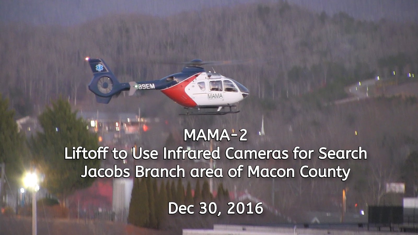
Sheriffs Office, Local VFDs and Helicopter Search for Missing Man in Jacobs Branch Area of Macon County
UPDATE: The Missing Man has been Located!

Updates are being posted at the end of this article.
The man was located at about 8:10 pm this evening!


Macon County Sheriff Office, Franklin Fire Department and Cowee Fire Departments, along with MAMA-2 using an Infrared camera system, have been searching for a missing older man in the Jacobs Branch area this evening.

Franklin Fire Department was called out at 4:44 pm and the Command Post at 1120 Jacobs Branch Road requested Cowee Fire Department join the search at 6:04 pm this evening as initial searches around the residence did not find the missing man. MAMA-2 lifted off at about 6:20 pm to join the search.


Macon County Emergency Management has sent out a Code Red message to all residents in the area.

This is a codered message from the Macon County 911 Center. We are looking for an elderly white male that wandered away from his residence near Jacobs Branch Road. He is 6'1" tall, 180 lbs, has gray eyes, white hair, last seen wearing brown work boots, gray hat, black jacket, and blue jeans. Last seen around 2 pm today. Any contact with this male, call 911.


DAY SPONSOR


Carrion Tree Service is underwriting the daily weather briefing and public safety updates for today. they are a fully licensed and insured tree service, specializing in dangerous tree removal, view clearing, pruning, and crane services with a 24 Hour emergency response.
Their phone number is 371-4718. They are located at 120 Depot Street.
They can handle all your tree removal needs in good or bad weather.


UPDATES IN REVERSE CHRONOLOGICAL ORDER

**9:06 pm** Medic 3 reports the patient has refused transport and they are clear of the scene.

**8:31 pm** An update from Macon County Emergency Management:

This is a codered message from the Macon County 911 Center. In reference to the missing elderly gentleman from earlier, he has been located. We would like to thank the community for all of their help and cooperation in this matter. Thank you.

**8:12 pm** Confirmation that Mr Gillette has been located! 
(name will be posted after it appears in other news outlets)

**8:10 pm** The Command Post has reported the man has possibly been found. EMS (Medic 3) has been dispatched to the location.  The condition of the man was not clear.

**7:42 pm** MAMA-2 has returned to Angel Medical Center. They will be changing pilot and crew for the nightshift. The Jacobs Branch Command Post has requested they take off again to assist with the search. They have a Highway Patrol helicopter enroute from Salisbury with a two hour estimated time of arrival.


Downed trees lead to widely scattered electrical outages in Macon County

Readers are reporting trees in the roadways across the county this morning. Please be cautious as you head out today. The map included with this update shows locations where Duke Energy reports outages. Haywood EMC reports none of their customers are out of service this morning in Macon County.

I have added the NCDOT to the scanner feed at MaconScan.com so you can listen to their crews as the remove trees from the roads, but they do not not always tell on the radio where they are operating.

Macon County is currently under a Wind Advisory, and winds will be peaking between 10 am and 1 pm today, so continue to be vigilant about keeping an eye out for downed trees.

HOW TO REPORT AN ELECTRICAL OUTAGE

Do not touch a power line or anything in contact with it and keep others away until help arrives.

Duke Energy

Call 800.769.3766 or in Spanish 866.4.Apagón (866.427.2466).

If you see a fallen power line or safety hazard, call Duke Energy at 800.Power.On (800.769.3766) or in Spanish 866.4.Apagón (866.427.2466) or contact your local emergency services immediately.


Haywood EMC

To report or inquire about power outages, call 1-800-951-6088


DAY SPONSOR

Carrion Tree Service is underwriting the daily weather briefing and public safety updates for today. they are a fully licensed and insured tree service, specializing in dangerous tree removal, view clearing, pruning, and crane services with a 24 Hour emergency response.
Their phone number is 371-4718. They are located at 120 Depot Street.
They can handle all your tree removal needs in good or bad weather.


WEATHER SPONSOR

Today's weather coverage is being underwritten by Pennington's Paint & Body, your Franklin area collision repair shop. Stop by for a free repair estimate with 50% off your insurance deductible and a lifetime warranty.
Give them a call at (828) 524-3992. They are located at 471 Depot street behind Berry's tire & Amerigas.


Letter to the Editor
Christmas made brighter for those in need


The Macon County Department of Social Services would like to extend our most sincere appreciation to the following sponsors in helping us make Christmas brighter for the children, the families, and the individuals we serve. Thank you for helping us to fulfill our mission of partnering to promote, protect, and strengthen our community.


Matt Bateman, Franklin Fitness Center
Jeff Cloer
Coweeta Hydrologic Laboratory Employees
Discover Church
Chris and Amanda Duke
Franklin High School French Club and Lisa Welch
Franklin High School Student Athletes and Taylor Rogers
Michelle Graham of Raleigh, NC
Sheriff Robert L. Holland and the Macon County Sheriff’s Office
Terell and Linda Johnson
Junaluskee Lodge #145 AF&AM Members
Jonathan and Megan Keener
Jane Long
Amy Manshack, State Farm Insurance
Lee and Teri Marshall of Orange City, FL
Rachel Marshall
Cheryl McCune of Portage, IN
Alan and Alpha Shoffeitt
Snow Hill United Methodist Church
Watauga Baptist Church and Dr. Wesley Price


If you are interested in supporting a foster child at any time of the year, please contact Stacey Messer at 828-349-2546.

R. Patrick Betancourt, Director – Franklin, N.C.

Our Mission: Partnering to promote, protect, and strengthen our community.

MACON COUNTY WEATHER BRIEFING
FRIDAY, DECEMBER 30, 2016


OVERVIEW

Cold high pressure will dominate the local weather pattern through Saturday. Increased moisture from the Gulf of Mexico will result in increased chances of rain through Tuesday.

HOW TO REPORT AN ELECTRICAL OUTAGE

Duke Energy

Call 800.769.3766 or in Spanish 866.4.Apagón (866.427.2466).

If you see a fallen power line or safety hazard, call Duke Energy at 800.Power.On (800.769.3766) or in Spanish 866.4.Apagón (866.427.2466) or contact your local emergency services immediately. Do not touch a power line or anything in contact with it and keep others away until help arrives.

Haywood EMC

To report or inquire about power outages, call 1-800-951-6088


DAY SPONSOR

Carrion Tree Service is underwriting the daily weather briefing and public safety updates for today. they are a fully licensed and insured tree service, specializing

in dangerous tree removal, view clearing, pruning, and crane services with a 24 Hour emergency response.

Their phone number is 371-4718. They are located at 120 Depot Street.

They can handle all your tree removal needs in good or bad weather.


WEATHER SPONSOR

Today's weather coverage is being underwritten by Pennington's Paint & Body, your Franklin area collision repair shop. Stop by for a free repair estimate with 50% off your insurance deductible and a lifetime warranty.
Give them a call at (828) 524-3992 Located at 471 Depot street behind Berry's tire & Amerigas.


THREE DAY OUTLOOK


Friday (Wind Advisory in effect until 6 pm)

Mostly sunny with highs near the upper 30s and wind chills making it feel like it is in the 20s for much of the day. Winds will be out of the northwest 10 to 15 mph, gusting to 35 mph. Wind speeds should peak between 10 am and 1 pm.


Friday Night

Mostly clear with lows near the low to mid 20s. Winds out of the northwest calming before midnight.


Saturday

Partly sunny with highs near the mid to upper 40s and increasing clouds.


New Year's Eve

Cloudy with lows near the mid 30s. 60% chance of rain/sleet/snow early, then rain after 9 pm. Winds from the southeast early calming before midnight.


New Year's Day

Cloudy with highs near 50 and a 70% chance of rain, mainly before 2 pm.


Sunday Night

Cloudy with lows near the mid 40s. 80% chance of rain.


HAZARDS

An area of high winds continues to move through our area, with scattered power outages likely.

The National Weather Service has issued a Wind Advisory that will be in effect for our region until 6 pm this evening. The full text of the Advisory is posted below for your convenience.


***Wind Advisory***
URGENT - WEATHER MESSAGE
NATIONAL WEATHER SERVICE GREENVILLE-SPARTANBURG SC
841 PM EST THU DEC 29 2016

...STRONG WINDS EXPECTED ACROSS THE NORTH CAROLINA AND GEORGIA MOUNTAINS TONIGHT THROUGH FRIDAY...

.STRONG GUSTY NORTHWEST WINDS WILL CONTINUE ACROSS THE NORTH CAROLINA AND GEORGIA MOUNTAINS TONIGHT THROUGH THE DAY ON FRIDAY.


...WIND ADVISORY REMAINS IN EFFECT UNTIL 6 PM EST FRIDAY...

* LOCATIONS...THE MOUNTAINS OF WESTERN NORTH CAROLINA AND NORTHEAST GEORGIA.

* HAZARDS...VERY WINDY CONDITIONS.

* TIMING...THROUGH THE DAYLIGHT HOURS ON FRIDAY.

* WINDS...NORTHWEST 30 TO 40 MPH WITH GUSTS UP TO 55 MPH.

* IMPACTS...STRONG WINDS MAY BLOW DOWN LIMBS...TREES...AND POWER LINES. SCATTERED POWER OUTAGES ARE EXPECTED.

PRECAUTIONARY/PREPAREDNESS ACTIONS...

A WIND ADVISORY MEANS THAT WINDS OF 35 MPH ARE EXPECTED. WINDS THIS STRONG CAN MAKE DRIVING DIFFICULT...ESPECIALLY FOR HIGH PROFILE VEHICLES. USE EXTRA CAUTION.

STAY TUNED TO NOAA WEATHER RADIO OR YOUR FAVORITE SOURCE OF WEATHER INFORMATION FOR THE LATEST UPDATES. ADDITIONAL DETAILS CAN BE FOUND AT WWW.WEATHER.GOV/GSP.


POLLEN/AIR QUALITY

Pollen levels are expected to remain low today and low tomorrow, with ragweed and grasses being the main sources of pollen.

Air Quality

All green for today.

For a display of the most recent air quality conditions, please visit the US EPA's AIRNOW.gov web site.

FOR ADDITIONAL INFORMATION... PLEASE VISIT THE NORTH CAROLINA DIVISION OF AIR QUALITY WEB SITE AT WWW.NCAIR.ORG/AIRAWARE/FORECAST/.


CROWD FUNDING OR DAY SPONSORSHIP OPPORTUNITIES

If you receive value from what Macon Media provides to the community, please consider becoming a supporter and contribute at least a dollar a month.

If you have a business or event you are interested in sponsorship opportunities or underwriting coverage, send an email to editor@MaconMedia.com for more information. Serious inquiries only.

Thank You to the people who have been sending in donations and those businesses who are underwriting coverage of news and events. You have kept Macon Media online.


You can find out more information on how to do that and some of what I plan to accomplish if I reach certain levels of funding at >> https://www.patreon.com/MaconMedia 


Published at 5:00 am on Dec 30, 2016

#WNCscan #MaconWx #MaconSafety

 Be kind to one another.


Wednesday, December 28, 2016

Dense Fog Advisory Issued Until 9 am

Area impacted by Advisory 
Map Courtesty of National Weather Service


The National Weather Service has issued a Dense Fog Advisory for our area this morning until 9 am.

Please exercise caution on the roads this morning and please burn your headlights so other drivers can see you. Here is the full text of the advisory:

***Dense Fog Advisory***
URGENT - WEATHER MESSAGE
NATIONAL WEATHER SERVICE GREENVILLE-SPARTANBURG SC
221 AM EST WED DEC 28 2016

...DENSE FOG ADVISORY IN EFFECT...

.DENSE FOG IS EXPECTED TO REDUCE VISIBILITY INTO EARLY THIS MORNING IN PORTIONS OF THE LITTLE TENNESSEE RIVER VALLEY OF SOUTHWEST NORTH CAROLINA AND RABUN COUNTY GEORGIA.


...DENSE FOG ADVISORY IN EFFECT UNTIL 9 AM EST THIS MORNING...

THE NATIONAL WEATHER SERVICE IN GREENVILLE-SPARTANBURG HAS ISSUED A DENSE FOG ADVISORY...WHICH IS IN EFFECT UNTIL 9 AM EST THIS MORNING.

* LOCATIONS...THE LITTLE TENNESSEE RIVER VALLEY OF SOUTHWEST NORTH CAROLIN AND RABUN COUNTY GEORGIA.

* VISIBILITY...LESS THAN ONE QUARTER OF A MILE.

* IMPACTS...DANGEROUS DRIVING CONDITIONS.

PRECAUTIONARY/PREPAREDNESS ACTIONS...

A DENSE FOG ADVISORY MEANS VISIBILITIES WILL FREQUENTLY BE REDUCED TO LESS THAN ONE QUARTER MILE. IF DRIVING...SLOW DOWN... USE YOUR HEADLIGHTS...AND LEAVE PLENTY OF DISTANCE AHEAD OF YOU.

WEATHER SPONSOR

Today's weather coverage is being underwritten by Pennington's Paint & Body, your Franklin area collision repair shop. Stop by for a free repair estimate with 50% off your insurance deductible and a lifetime warranty.
Give them a call at (828) 524-3992 Located at 471 Depot street behind Berry's tire & Amerigas.

Tuesday, December 27, 2016

Knoxville News Sentinel: Social media underused in Gatlinburg firestorm
A Personal View

Photo courtesy Tennessee National Guard


Excerpt from the article:
A spokeswoman for Gatlinburg said neither the city nor its public safety agencies had any social media accounts when the Nov. 28 inferno responsible for 14 deaths, more than 180 injuries and the damage or destruction of more than 2,400 structures struck the city. Officials said damage from the fire will exceed $500 million.
Since the disaster, spokeswoman Marci Claude said, the Gatlinburg Police Department "has created a Facebook page to share information with the community."
In contrast, officials with the Great Smoky Mountains National Park continuously updated information on its Facebook page and Twitter account throughout the day warning of the growing danger. National Park officials warned of the unpredictable fire, the increasing winds moving flames toward Gatlinburg and ongoing evacuations within the park.
The park started sharing information at 10:46 a.m. on Nov. 28 about the fires marching north toward Gatlinburg.

Read the entire article on Knoxville News Sentinel
This is so sad. Too many in local governments look down on social media as a tool, or view it as a tool to build personal fiefdoms.
The failure of Sevier County to deliver information to residents has probably resulted in the deaths of some of the people they were responsible for protecting. Of course, they would not have been in that situation had the Chimney Top Fire been set. I know a lot of people hesitate to blame their local government when they make mistakes, or fail to properly do their duty. That kind of behavior needs to stop. The only way anyone, even governments, can improve is to acknowledge mistakes and work to make sure they don't happen again. Wildfire Today has an excellent article analyzing the events that led up to the firestorm. [WildFire Today]
The article points out that the National Park Service had been warning of the approaching wind event. The Incident Command Team in our area had been preparing for it for days by burning out the Camp Branch Fire and patrolling fire lines on the other fires.
In the daily weather briefing that was published at 5 am on Monday morning, Macon Media warned of the high wind event that was coming. [LINK] When it did get here, downed power lines did spark fires, but our volunteer firefighters were prepared and stopped them from spreading.

COMMENTARY
(I probably shouldn't post this commentary because it goes against the general policy I have established for Macon Media of not expressing an opinion on news items. --Bobby Coggins).

A lot of elected officials and bureaucrats in our area tend to either look down on social media, mock it as a source of "fake news," or use it in a fashion that limits who can see official updates. The ones here who tend to do use it, share official information on personal profiles with privacy settings that mean only their friends can see the information and it cannot be shared outside that circle of friends unless it is copied and pasted, which one of the news outlets here tends to do.

My personal experience during our wildfires was that getting information out of the local county government was a mixed affair and other news outlets were given access Macon Media was denied. Some department heads were generous with sharing information (I won't name those who helped because I don't want to potentially get them in trouble), while others would always point me to other department heads or the PIO of the Health Department.

Once I contacted Rabun and Jackson Counties and requested information, they were very professional and timely with sharing information for me to relay to the public.

The USFS was wonderful to work with and they were professional and timely in delivering information. Because of the workflow and open design of the USFS and the National Interagency FIre Cache websites in creating maps and compiling data, I often had information hours before the daily morning briefings at the Command Post were presented. The Daily Briefings at the Command Post in Franklin were, according to what I was told, "not for the press or public" while the Daily Briefings for the Rock Mountain Fire were streamed live online, so there were differences in the way the ICTs (Incident Command Teams) viewed their role in delivering information to the public.

McCRORY VISIT

Macon Media and The Macon County News and Shopping Guide almost missed the visit of the governor to the local Command Post even though we arrived early and checked in with both the CP and the governor's staff. I would not even have known of the visit had someone had not gone outside the chain of command and told me. We were in the lobby with a state senator waiting to be told the governor had arrived and were never notified when he arrived. If the reporter for the Macon County News had not got up and just went back to a briefing room in the back I had not been aware existed, but she did, neither of us would have been able to cover the story from a first person perspective. Of course, a reporter from The Franklin Press was already there in the briefing when we arrived, having been given access we were not.

SOLUTIONS AND A LOOK AHEAD


In 2017, I will be more aggressive in obtaining official information held by local, state and federal bodies to share with the public. In the past, I have been far too passive in this regard. I will clearly identify those who are difficult to work with and those who favor certain news outlets over others. When I do share observations or opinions, they will be clearly marked as such so you can decide if you agree or not.

As always, when I make mistakes (and I inevitably will) feel free to let me know. When you do that, you help Macon Media become better at delivering accurate information. It is my personal view that news collection, interpretation and delivery is a collaborative effort, and will become even more so in the future, and not something just for elite "journalists" to tell you what is important or what to believe or who act as cheer leaders for local government when they should be holding their feet to the fire. Cheer leading the local government is the job of county employees. The proper role of the media is to deliver accurate information and to dig for news, not to be the local pravda.

CROWD FUNDING OR DAY SPONSORSHIP OPPORTUNITIES
If you receive value from what Macon Media provides to the community, please consider becoming a supporter and contribute at least a dollar a month.
If you have a business or event you are interested in sponsorship opportunities or underwriting coverage, send an email to editor@MaconMedia.com for more information. Serious inquiries only.
Thank You to the people who have been sending in donations and those businesses who are underwriting coverage of news and events. You have kept Macon Media online. Your generosity has blown my mind and I will be forever grateful.
You can find out more information on how to do that and some of what I plan to accomplish if I reach certain levels of funding at >> https://www.patreon.com/MaconMedia

Tuesday, December 20, 2016

Macon County Board of Education
December 2016 Meeting


The Macon County Board of Education held it's meeting for December 2016 last night. Here is the full video of the meeting.


MEDIA ROLL CALL
(media outlets with reporters present at the meting)

Macon Media
The Franklin Press
The Macon County News and Shopping Guide
WFSC-AM/WNCC-FM


Individual segments from the meeting will be posted separately, and links to each segment will be added here as they are published. The mini-agenda that the school board sends out to the media is embedded below.


CROWD FUNDING OR DAY SPONSORSHIP OPPORTUNITIES

If you receive value from what Macon Media provides to the community, please consider becoming a supporter and contribute at least a dollar a month.

If you have a business or event you are interested in sponsorship opportunities or underwriting coverage, send an email to editor@MaconMedia.com for more information. Serious inquiries only.

Thank You to the people who have been sending in donations and those businesses who are underwriting coverage of news and events. You have kept Macon Media online.


You can find out more information on how to do that and some of what I plan to accomplish if I reach certain levels of funding at >> https://www.patreon.com/MaconMedia


Friday, December 16, 2016

Morning Time Lapse for December 16, 2016


The evolution of colors this morning was spectacular!

Here is a time lapse taken from the Wal-Mart parking lot this morning of the sky before sunrise this morning. You can also see photos taken by other people that were posted to the Macon Media Weather Page. [LINK]


West Macon Fire Department and NC Forest Service Extinguish Loose Fire Caused by a Downed Power Line

Map showing location of fire 
Map Coordinates provided by NC Forest Service

West Macon Fire Department and the North Carolina Forest Service responded to report of a small grass fire caused by downed power lines. The location was reported to be near the intersection of Wayah Road and Crawford Road. The fire was quickly extinguished and, as of press time [9:03 am] firefighters were still waiting for Duke Energy crews to arrive on the scene and begin repairs. No outages were displayed on the Duke Energy map. This post will be updated if conditions warrant.

A Wind Advisory has been issued by the National Weather Service from 7 pm tonight until 10 am Saturday morning and more outages are possible tonight due to the expected wind. [More Information]

UPDATE **9:13 am**  

Duke Energy reports 4 customers are impacted by this outage and restoration is expected to be complete by 1 pm today. The map shows the approximate location of this event. [CURRENT MAP]


Map showing approximate location of outages 
Date provided by Duke Energy


CROWD FUNDING OR DAY SPONSORSHIP OPPORTUNITIES

If you receive value from what Macon Media provides to the community, please consider becoming a supporter and contribute at least a dollar a month.

If you have a business or event you are interested in sponsorship opportunities or underwriting coverage, send an email to editor@MaconMedia.com for more information. Serious inquiries only.

Thank You to the people who have been sending in donations and those businesses who are underwriting coverage of news and events. You have kept Macon Media online.


You can find out more information on how to do that and some of what I plan to accomplish if I reach certain levels of funding at >> https://www.patreon.com/MaconMedia


Legislative Calendar for December 16, 2016

The State Legislature Building


Background

The state legislature is having two Special Sessions this week. The first was called for by Governor Pat McCrory on December 9th [PROCLAMATION] to address disaster relief for Hurricane Matthew in the east and the Wildfires in the west. During this session, the state legislature passed The Disaster Recovery Act of 2016 [SEE TEXT] [DOWNLOAD PDF] [VOTING HISTORY/VERSIONS].

The state legislature then called a fourth Special Session [PROCLAMATION] for the balance of the week.

TODAY

The state legislature will convene today, with the NC Senate [LINK] beginning work at 8:30 am and the NC House [LINK] beginning at 9:30 am. Various committees will also be meeting today. A calendar of scheduled legislative activity along with links to where you can listen online to our state legislators as they go about their tasks is posted at the end of this article. I plan on listening and recording what I can, so be sure to check back later today and see what audio I've managed to upload.


Legislative Calendar for December 16, 2016

8:00 AMFinance Committee -- Bi-Partisan Ethics, Elections & Court Reform -- CORRECTED [MEMBERS] [WEBSITE]544 LOB [LIVE AUDIO]
8:30 AMSession Convenes (Senate)SENATE [LIVE AUDIO]
9:30 AMSession Convenes (House) HOUSE [LIVE AUDIO]
9:30 AMEducation/Higher Education (Senate)
[MEMBERS] [NO WEBSITE]
544 LOB [LIVE AUDIO]
11:00 AMAppropriations/Base Budget (Senate)
[MEMBERS] [WEBSITE]
643 LOB [LIVE AUDIO]


CROWD FUNDING OR DAY SPONSORSHIP OPPORTUNITIES

If you receive value from what Macon Media provides to the community, please consider becoming a supporter and contribute at least a dollar a month.

If you have a business or event you are interested in sponsorship opportunities or underwriting coverage, send an email to editor@MaconMedia.com for more information. Serious inquiries only.

Thank You to the people who have been sending in donations and those businesses who are underwriting coverage of news and events. You have kept Macon Media online.


You can find out more information on how to do that and some of what I plan to accomplish if I reach certain levels of funding at >> https://www.patreon.com/MaconMedia 

National Weather Service Issues Wind Advisory
High Winds Above 3500 feet, Scattered Power Outages Possible

Map of Advisory Coverage 
Click to Enlarge


The National Weather Service has issued a Wind Advisory for our region above 3500 feet. Winds on the ridgetops will be coming out of the southwest 2 to 35 mph, gusting to 50 mph or more overnight tonight and into the morning on Saturday. The full text is at the end of this update.

Winds will not be as high for us in the valleys, but we will notice the higher winds. Our impact will be in the form of power outages as winds at higher elevations knock tree limbs and trees onto power lines and cause scattered power outages.


WEATHER SPONSOR
Pennington's Paint & Body
Your Franklin area collision repair shop. Stop by for a free repair estimate with 50% off your insurance deductible and a lifetime warranty. 

Give them a call at (828) 524-3992 Located at 471 Depot street behind Berry's tire & Amerigas.

***Wind Advisory***

URGENT - WEATHER MESSAGE
NATIONAL WEATHER SERVICE GREENVILLE-SPARTANBURG SC
343 AM EST FRI DEC 16 2016


...Strong winds expected across the higher peaks and ridgetops of the southwest North Carolina mountains tonight...
...Wind advisory in effect from 7 pm this evening to 10 am est Saturday above 3500 feet...
The National Weather Service in Greenville-Spartanburg has issued a wind advisory above 3500 feet... Which is in effect from 7 pm this evening to 10 am est Saturday.
* locations...Peaks and ridgetops of the southwest North Carolina mountains.
* hazards...Very windy conditions.
* timing...Gusty southwest winds will strengthen tonight and will remain strong through mid morning Saturday.
* winds...Southwest 25 to 35 mph with gusts up to 50 mph.
* impacts...Strong winds may blow down limbs... Trees... And power lines. Scattered power outages are expected.
Precautionary/preparedness actions...
A wind advisory means that winds of 35 mph are expected. Winds this strong can make driving difficult... Especially for high profile vehicles. Use extra caution.
Stay tuned to NOAA weather radio or your favorite source of weather information for the latest updates. Additional details can be found at www.Weather.Gov/gsp.

Tuesday, December 13, 2016

Southwestern Commission - Mayor's Meeting
Roundabout Presentation


The Southwestern Commission Rural Planning Organization held a Mayor's Meeting of Mayors from around the seven westernmost counties in North Carolina today in the town hall. The group heard a presentation by Michael P. Reese, P.E., an engineer with the NCDOT Congestion Management Section, on Modern Roundabouts.

He went over the history of Roundabouts in North Carolina and discussed the advantages of having roundabouts. Afterward, he took questions from the Mayor, their staff and board members who were present. The video included with this article contains the full presentation.


My Reese also had brochures available for those present to take with them.

Macon Media has links to where you can view these brochures for yourselves.


[Federal Highway Administration] I could not find a copy of the brochure he had, but these two give you the general idea of the information in the document.


MEDIA ROLL CALL
(media outlets with reporters/photographers present)

Macon Media
The Franklin Press


CROWD FUNDING OR DAY SPONSORSHIP OPPORTUNITIES

If you receive value from what Macon Media provides to the community, please consider becoming a supporter and contribute at least a dollar a month.

If you have a business or event you are interested in sponsorship opportunities or underwriting coverage, send an email to editor@MaconMedia.com for more information. Serious inquiries only.

Thank You to the people who have been sending in donations and those businesses who are underwriting coverage of news and events. You have kept Macon Media online.


You can find out more information on how to do that and some of what I plan to accomplish if I reach certain levels of funding at >> https://www.patreon.com/MaconMedia

Whitewater Falls on the Nantahala National Forest Closed

Whitewater Falls, Eastatoe, NC 8910

PRESS RELEASE
National Forests in North Carolina
160A Zillicoa St.
Asheville, N.C. 28801


Asheville, NC - December 12, 2016 - Whitewater Falls and the Foothills Trail (TR 437) that connects to Whitewater Falls on the Nantahala Ranger District is expected to remain closed for some time.
Although the Whitewater Fire was only 23 acres, it totally destroyed the staircase and access facility to the Whitewater Falls observation deck. Due to the steep terrain, the site is unsafe and dangerous to the public.
"I regret the impact that this closure causes for the 75,000 plus people who visit this site every year, however, safety must be our first consideration," said District Ranger Mike Wilkins.
The area will remain closed until funding can be secured and reconstruction can be completed. The National Forests in North Carolina is currently working with the Federal Highways Administration-Eastern Federal Lands to secure funding.
The cause of the Whitewater Fire is under investigation. 

Benefit Planned for Cali Smolarsky in Highlands


A 21 year old former student at Highlands School has been diagnosed with stage 3 breast cancer.  She had her first round of treatments last week.  A benefit has been planned for this Saturday, December 17th at the Highlands Rec Park. A Pasta Dinner, Raffle and an Auction is being planned to assist with medical costs. MOre information is posted below:


It Takes A Village

Raffle Drive

*1991 Suzuki Samurai Auction-

$25 each or 5 for $100

Drawing Feb. 3rd

*Nascar Style Go-Cart-

donated by Henry and Marie Bowie

$10 each or 3 for $25

Drawing Dec. 17 th

*White Tickets: 43 inch TV-

donated by Custom Sound and Security

$5 each or 6 for $25

Drawing Dec. 17th

*Red Tickets: Ruger Mark III 20 mm Pistol

donated by Reeves’ Hardware-

$1 each or 6 for $5

Drawing Dec. 17th

*Blue Tickets: $100 gas card

donated by Farmer’s Market-

$1 each or 6 for $5

Drawing Dec. 17 th

It Takes A Village


*All Proceeds Benefit the It Takes a Village/ Cali Smolarsky Fund*


xx


Saturday, December 10, 2016

USFS Release: Every Kid in a Park


PRESS RELEASE

National Forests in North Carolina
160A Zillicoa St.
Asheville, NC 28801


Asheville, NC - December 9, 2016 - Fourth graders can visit the Every Kid in a Park website to obtain a free pass that provides access to federally managed lands and waters - including national parks, forests, wildlife refuges, and marine sanctuaries.

The Forest Service offers places for hiking, biking, skiing, nature viewing, and scenic drives. Many of the facilities and services associated with these opportunities are free. However, some do require fees or permits to help maintain, manage, and improve your national forests and grasslands. Through the Every Kid in a Park program, fourth graders can obtain a pass for free access to 2,000-plus federal land and water sites across the US for one full year.
Every Kid in a Park is a multi-agency initiative, which started in the fall of 2015.

The Every Kid in a Park pass - which features a new design for this year's students - is valid from September 1, 2016 through August 31, 2017 and grants free entry for fourth graders and up to three accompanying adults (or an entire non-commerical vehicle for drive-in parks) at more than 2,000 sites across the country.

By introducing fourth graders to public lands in their backyards and beyond at an impressionable age, Every Kid in a Park inspires the next generation to discover all that our nation's public lands and waters have to offer, including opportunities to be active, spend time with friends and family, and serve as living classrooms to build critical skills.


Friday, December 9, 2016

Macon County Planning Board
December 2016


Members of the Macon County Planning Board met at the Robert C Carpenter Community BUilding late yesterday afternoon. A quorum was not present, so no official business could be conducted.

Members that were present discussed the elements of the Macon County Comprehensive Plan they've been working to update. The next meeting is scheduled for January 19, 2017.


MACON COUNTY PLANNING BOARD


AGENDA ITEMS DATE: December 8, 2016


ORDER OF BUSINESS


CALL TO ORDER-

Adjustment to and Approval of the Agenda-

APPROVAL OF MINUTES- Approval of Minutes from Oct. 20, 2016 meeting

LIAISON COMMENTS- Commissioner Shields

PUBLIC COMMENT- Public input is always appreciated, we ask that comments be limited to 4 minutes and refer to a current topic the planning board is discussing.

PRESENTATIONS - None

OLD BUSINESS - Discussion of Comprehensive Plan

New Business- None

ANNOUNCEMENTS – Additional announcements:

-Next Meeting Date & Location:


MEDIA ROLL CALL
(media outlets with reporters/photographers present)

Macon Media
The Franklin Press


CROWD FUNDING OR DAY SPONSORSHIP OPPORTUNITIES

If you receive value from what Macon Media provides to the community, please consider becoming a supporter and contribute at least a dollar a month.

If you have a business or event you are interested in sponsorship opportunities or underwriting coverage, send an email to editor@MaconMedia.com for more information. Serious inquiries only.

Thank You to the people who have been sending in donations and those businesses who are underwriting coverage of news and events. You have kept Macon Media online.


You can find out more information on how to do that and some of what I plan to accomplish if I reach certain levels of funding at >> https://www.patreon.com/MaconMedia


Wednesday, December 7, 2016

Macon County Board of Elections Recount Ballots in State Auditors Race

Ballots being recounted in the State Auditors race in the Macon County Board of Elections office on the morning of December 7, 2016.

The State Board of Elections has ordered a recount in the State Auditor's Race be complete by Thursday afternoon, December 8th, and the local board will be having their recount beginning at 8:30 am in the morning.. The State Board will then certify the results on Friday, the 9th of December.


[Read more about this developing storyat the Raleigh News and Obsever http://www.newsobserver.com/news/politics-government/politics-columns-blogs/under-the-dome/article119136798.html ]


The statewide results in this race close, with Woods coming out ahead by less than 6,000 votes.


Beth A. Wood 2,259,383 50.07%

Chuck Stuber 2,253,390 49.93%


In Macon County, Stuber won by about 5,000 votes.


Chuck Stuber 10,813 65.01%

Beth A. Wood   5,821 34.99%


Here is the Press Release:


NOTICE OF EMERGENCY MEETING 

MACON COUNTY BOARD OF ELECTIONS


Macon County Board of Elections will meet Wednesday, December 7, 2016 at 8:30 am to conduct a recount of the contest of NC Auditor’s race, candidates Beth A. Wood and Chuck Stuber from November 8, 2016 General Election. The recount location is Macon County Board of Elections office located on the first floor of the Macon County Courthouse, 5 W Main Street, Franklin, NC 28734. 


Luke Bateman, Chairman

Macon County Board of Elections


Monday, December 5, 2016

Macon County Commissioners
Continued Meeting for 12-05-2016


The Macon County Commissioners will be meeting briefly at 6:30 pm tonight to swear in the returning Commissioner Paul Higdon and new Commissioner Karl Gillespie, then elect a chairman and vice-chairman of the Board, examine the bond for elected critters in Macon County, then set forth a meeting agenda for the coming year.


MACON COUNTY BOARD OF COMMISSIONERS
CONTINUED SESSION
DECEMBER 5, 2016 — 6:30 PM.
AGENDA

. Oaths of office for Commissioner Higdon and Commissioner-elect Gillespie -
Senior Resident Superior Court Judge William H. Coward

. Call to order — County Manager

. Election of chairman — County Manager

. Election of vice-chairman

. Examination of the Official Bond for Public Officials of Macon County
. Consideration of the 2017 regular meeting schedule

. Adjourn


Live video of the meeting may be seen at the embedded player below. Once the meeting is over and video edited and processed, the live player will be replaced by the edited video. Until the meeting starts, you will see past live webcasts of events and meetings.


DAY SPONSOR

Carrion Tree Service is underwriting the daily weather briefing and public safety updates for today. they are a fully licensed and insured tree service, specializing 

in dangerous tree removal, view clearing, pruning, and crane services with a 24 Hour emergency response. 

Their phone number is 371-4718. They are located at 120 Depot Street.


They can handle all your tree removal needs in good or bad weather.


CROWD FUNDING OR DAY SPONSORSHIP OPPORTUNITIES

If you receive value from what Macon Media provides to the community, please consider becoming a supporter and contribute at least a dollar a month.

If you have a business or event you are interested in sponsorship opportunities or underwriting coverage, send an email to editor@MaconMedia.com for more information. Serious inquiries only.

Thank You to the people who have been sending in donations and those businesses who are underwriting coverage of news and events. You have kept Macon Media online.


You can find out more information on how to do that and some of what I plan to accomplish if I reach certain levels of funding at >> https://www.patreon.com/MaconMedia