


Here is an index to assist you in moving from section to section within the article.
Back to Top
Weather
Hazards and Tropical Weather
Almanac
Macon Calendar
Local and StateNews
Russo-UKrainian War Updates
National News Roundup
COVID-19 News and Updates
Science and Technology
Russo-Ukrainian War Videos (mostly long form)
On This Day
Support Macon Media
GENERAL OUTLOOK
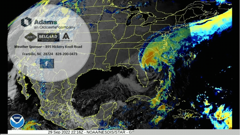
High pressure building across the Great Lakes region will keep conditions dry and relatively cooler today. Into Friday and the weekend, Hurricane Ian will continue to track north and move into the region. Widespread rainfall, flooding and gusty winds are possible.
FOG FAIR SCHEDULED FOR SATURDAY, NOV 5th FROM 10AM TO 4PM
Friends of the Greenway announce their Fall arts and crafts fundraising event. FROG FAIR will be held Nov 5, 2022 from 10-4 at FROG Quarters, 573 E. Main at the Town bridge in Franklin. Vendor spaces are available (only registration fee goes to FROG)--check our website (littletennessee.org) for registration forms or stop by FROG Quarters. Make sure to mark your calendar--arts and crafts, food, and music will make it a special day. For more information, email frog28734@gmail.com.
---BEGIN SPONSOR SEGMENT---
Weather Sponsor

Adams Products, a Division of Oldcastle is underwriting the daily weather briefing & public safety updates for the month.
Open 7:30 AM to 4:00 PM, M-F, located at 895 Hickory Knoll Road, Franklin, NC. Visit our Facebook page at: https://www.facebook.com/Adams.Oldcastle.Franklin.NC
All your masonry needs are available. Our phone number is 828.524.8545, the public is welcome, we’ll help you with your next project.
DAY SPONSOR

Macon Media is being underwritten today by Franklin Office Supply. Visit their store at 161 Highlands Road in Franklin or check out their website.
---END SPONSOR SEGMENT------
Back to Top
Local Weather
General Forecast Through Sunday Night

Franklin Area
Today
A 40 percent chance of rain, mainly after 2pm. Mostly cloudy, with highs in the upper 60s. Winds out of the north 5 to 10 mph. New rainfall amounts between a tenth and quarter of an inch possible.
Tonight
Rain likely before midnight, then showers, mainly after midnight. Patchy fog between 10pm and 1am. Lows around 50. Winds out of the northwest 5 to 10 mph. Chance of rain is 80%. New rainfall amounts between a quarter and half of an inch possible.
Saturday
Showers likely, mainly before 10am. Mostly cloudy, with highs in the lower 60s. Winds out of the northwest 5 to 10 mph. Chance of rain is 60%. New rainfall amounts of less than a tenth of an inch possible.
Saturday Night
A 30 percent chance of showers. Mostly cloudy, with lows around 50. Winds out of the northwest around 5 mph becoming calm before midnight.
Sunday
A slight chance of showers before 9am, then a chance of rain, then a chance of showers after 10am. Mostly cloudy, with highs in the mid 60s. Chance of rain is 40%.
Sunday Night
A 40 percent chance of showers before 1am. Mostly cloudy, with lows around 50.
Highlands Plateau
Today
Rain likely, mainly after 4pm. Mostly cloudy, with highs near 60. Winds out of the northeast 20 to 30 mph, with gusts as high as 45 mph. Chance of rain is 60%. New rainfall amounts between a tenth and quarter of an inch possible.
Tonight
Rain, mainly before midnight, then showers after midnight. Patchy fog between 9pm and 2am. Lows in the mid-to-upper 40s. Winds out of the northwest 20 to 35 mph, with gusts as high as 55 mph. Chance of rain is 80%. New rainfall amounts between a quarter and half of an inch possible.
Saturday
Showers likely, mainly before 10am. Mostly cloudy, with highs in the mid 50s. Winds out of the northwest 10 to 15 mph, with gusts as high as 25 mph. Chance of rain is 60%. New rainfall amounts between a tenth and quarter of an inch possible.
Saturday Night
A 30 percent chance of showers. Mostly cloudy, with lows in the upper 40s. Winds out of the north 5 to 10 mph.
Sunday
A chance of showers before 9am, then a chance of rain, then a chance of showers after 10am. Partly sunny, with highs in the mid 50s. Chance of rain is 40%.
Sunday Night
A 40 percent chance of showers before 2am. Mostly cloudy, with lows in the mid-to-upper 40s.
Otto and South Central Macon County
Today
A 40 percent chance of rain, mainly after 2pm. Mostly cloudy, with highs in the upper 60s. Winds out of the north 5 to 10 mph. New rainfall amounts between a tenth and quarter of an inch possible.
Tonight
Rain likely before midnight, then showers, mainly after midnight. Patchy fog between 11pm and 1am. Lows around 50. Winds out of the northwest 5 to 10 mph, with gusts as high as 20 mph. Chance of rain is 80%. New rainfall amounts between a quarter and half of an inch possible.
Saturday
Showers likely, mainly before 9am. Mostly cloudy, with highs near 60. Winds out of the northwest 5 to 10 mph. Chance of rain is 60%. New rainfall amounts of less than a tenth of an inch possible.
Saturday Night
A 30 percent chance of showers. Mostly cloudy, with lows around 50. Winds out of the northwest 3 to 5 mph.
Sunday
A slight chance of showers before 9am, then a chance of rain, then a chance of showers after 10am. Mostly cloudy, with highs in the low-to-mid 60s. Chance of rain is 40%.
Sunday Night
A 30 percent chance of showers before midnight. Mostly cloudy, with lows around 50.
Nantahala Area
Today
A 30 percent chance of rain, mainly after 3pm. Partly sunny, with highs in the mid 60s. Calm winds in the morning increasing to come out of the northeast 5 to 10 mph by midmorning. New rainfall amounts between a tenth and quarter of an inch possible.
Tonight
Rain likely, mainly between 9pm and midnight, then showers likely after midnight. Mostly cloudy, with lows around 50. Winds out of the northwest 5 to 10 mph. Chance of rain is 70%. New rainfall amounts between a quarter and half of an inch possible.
Saturday
Showers likely, mainly before 10am. Mostly cloudy, with highs in the upper 50s. Winds out of the northwest around 5 mph. Chance of rain is 60%. New rainfall amounts of less than a tenth of an inch possible.
Saturday Night
A 40 percent chance of showers. Mostly cloudy, with lows around 50. Winds out of the northwest 3 to 5 mph.
Sunday
A chance of showers before 9am, then a chance of rain, then a chance of showers after 10am. Mostly cloudy, with highs near 60. Chance of rain is 40%.
Sunday Night
A 40 percent chance of showers before midnight. Mostly cloudy, with lows around 50.
Back to Top
Hazards and Tropical Weather

The main impact from the passage of the remnants of Hurricane IAN will be to our east. We may see some increased winds, especially in the southeastern portion of Macon County.
Tropical Cyclone Ian and it`s remnants will track through the Carolinas Friday and Friday night. Widespread moderate to heavy rainfall and gusty winds will accompany it`s approach and passage.
TROPICAL WEATHER OUTLOOK

Tropical Weather Outlook
NWS National Hurricane Center Miami FL
200 AM EDT Fri Sep 30 2022
For the North Atlantic...Caribbean Sea and the Gulf of Mexico:
Active Systems:
The National Hurricane Center is issuing advisories on Hurricane Ian, located offshore of the northeastern coast of Florida.
1. Eastern Tropical Atlantic:
A broad area of showers and thunderstorms off the west coast of Africa is associated with a tropical wave. Environmental conditions are forecast to be conducive for gradual development, and a tropical depression could form early next week as the system moves westward to west-northwestward over the eastern tropical Atlantic.
* Formation chance through 48 hours...low...10 percent.
* Formation chance through 5 days...medium...50 percent.
Hurricane Ian Discussion Number 30
NWS National Hurricane Center Miami FL AL092022
1100 PM EDT Thu Sep 29 2022
Ian continues to have the appearance of a hybrid tropical cyclone, having the characteristics of both an extratropical low with some frontal features, and a sheared tropical cyclone with convection well removed from the low-level center. The system is interacting with a mid- to upper-level shortwave trough just to its west, and this interaction may be contributing to slight strengthening. Based on a blend of flight-level and SFMR-observed winds, along with dropsonde measurements, from an Air Force Hurricane Hunter aircraft the current intensity has been increased a little to 70 kt for this advisory. The strongest winds are currently occuring over the northwestern quadrant of the hurricane.
Southwesterly vertical wind shear is expected to remain high and the environmental air mass will stay dry until landfall. However, Ian could intensify a little more within the next 12 hours or so due to trough interaction and extraction of energy from the underlying warm Gulf Stream waters. Therefore the NHC forecast calls for slight strengthening before the system reaches the coast. This is above the available intensity model guidance. It should be emphasized that although Ian is not expected to be a classic hurricane at landfall, this does not diminish the threat it poses. Strong winds and storm surge will also extend far from the center and will begin well before the center arrives.
Ian continues to move north-northeastward at about 030/9 kt. Over the next day or so, the cyclone is expected to turn northward and then north-northwestward as it moves along the eastern side of the shortwave trough. The dynamical model consensus, TVCN, has again shifted slightly eastward on this cycle. Therefore the NHC track prediction is, again, moved a little eastward from the previous official forecast.
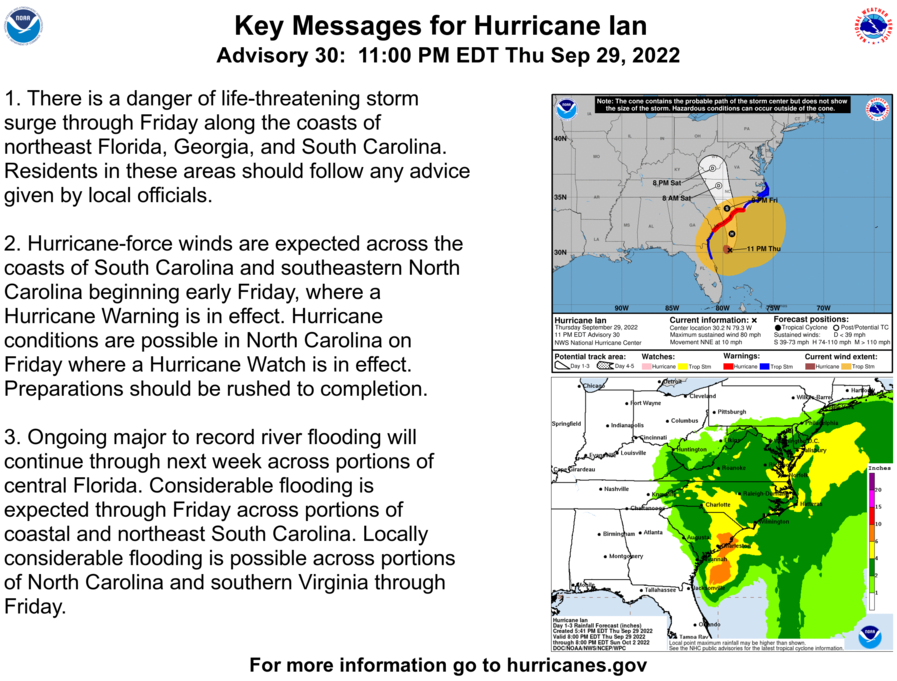
Key Messages:
1. There is a danger of life-threatening storm surge through Friday along the coasts of northeast Florida, Georgia, and South Carolina. Residents in these areas should follow any advice given by local officials.
2. Hurricane-force winds are expected across the coasts of South Carolina and southeastern North Carolina beginning early Friday, where a Hurricane Warning is in effect. Hurricane conditions are possible in North Carolina on Friday where a Hurricane Watch is in effect. Preparations should be rushed to completion.
3. Ongoing major to record river flooding will continue through next week across portions of central Florida. Considerable flooding is expected through Friday across portions of coastal and northeast South Carolina. Locally considerable flooding is possible across portions of North Carolina and southern Virginia through Friday.
FORECAST POSITIONS AND MAX WINDS
INIT 30/0300Z 30.2N 79.3W 70 KT 80 MPH
12H 30/1200Z 31.7N 79.1W 75 KT 85 MPH
24H 01/0000Z 34.0N 79.6W 60 KT 70 MPH...INLAND
36H 01/1200Z 36.0N 80.4W 30 KT 35 MPH...POST-TROP/EXTRATROP
48H 02/0000Z 37.5N 81.0W 20 KT 25 MPH...POST-TROP/EXTRATROP
60H 02/1200Z...DISSIPATED
TROPICAL TIDBITS
Tropical Tidbits is a website run by Macon Media's favorite no-nonsense tropical forecaster, Levi Cowan. He does not post material just to get clicks or to sensationalize the storms he covers to "make them more exciting." He is reliable and sober, unlike The Weather Channel crowd of Drama Queen Meteorologists.
Levi typically posts videos late in the afternoon or early before midnight on Youtube. [Youtube Channel]
[Thursday / Sept 29] Ian Crosses Florida; Landfall in South Carolina with Significant Impacts Expected Friday
What's Up in the Tropics with Mark Sudduth - September 29, 2022: Ian Headed for Carolinas After Devastating Impacts in Florida
Back to Top
Almanac
24 Hour Smoke Forecast
A smoke fieldmap was not provided for today. -->

Air quality is in the UPPER range of green for most of the county, with the ridges and other higher elevations today being in the UPPER range of green.
Fire and Smoke Map

Local Air Monitor

Pollen
Pollen levels are expected to be in the medium range 4.5 out of 12) today with Ragweed, Chenopods, and Grasses being the main culprits. Tomorrow is expected to be in the medium range (0.6 out of 12).
Record Weather Events for September 30th
Record weather events for this date in Macon County
(1872-2016)
Highest Temperature 89°F in Franklin in 1954
Lowest Temperature 27°F in Franklin in 1967
Greatest Rainfall 6.53 inches in Highlands in 1936
Highest Temperature 98°F in Franklin on 09-04-1975
Lowest Temperature 27°F in Franklin on 09-30-1967
Greatest Rainfall 11.87 inches in Highlands on 09-27-1964
Greatest Snowfall no measurable snowfall has been recorded since records started being kept in 1873
Weather Extremes for North Carolina for the month of September Data available from 1870 to 2018
Highest Temperature 108°F Belhaven, Beaufort County 09-25-1921
Lowest Temperature 23°F Marion, McDowell County 09-28-2000
Greatest One-Day Rainfall 21.00 in Wilmington, New Hanover County 09-17-2018
Monthly Averages
Warmest Weather Station 75.4°F Morehead City, Carteret County
Coldest Weather Station 55.0°F Mount Mitchell, Yancey County
Wettest Weather Station 8.93 in Southport, Brunswick County
Driest Weather Station 2.94 in Marshall, Madison County
Back to Top
Macon Calendar
(send your event to calendar@maconmedia.com)
Tuesday, October 4, 2022 - 1:30 - 2:30 p.m. in the Macon County Public Library Meeting Room-
Mental Health Class - Depression: From Surviving to Thriving
Depressive symptoms often present themselves through feelings of isolation, hopelessness, and despair. This course examines different types, common causes, symptoms, and treatment methods for depression, focusing on moving from a place of simply surviving to one of thriving.
This is a free event at Macon County Public Library; facilitated by the Vaya Health GERO team. CEU’s are provided through NC Department of Health and Human Services.
Thursday, October 6, 2022 - 6:00pm in the Macon County Public Library Meeting Room-
#OnigiriAction with Nanaka Okamura
Join Nanaka Okamura with Western Carolina University's Japanese Outreach Initiative as we honor World Food Day by making and enjoying Onigiri, the Japanese rice ball, to make our world a little better. (Please register at 828-524-3600 so we can plan for supplies)
Onigiri Action is an annual autumn social good campaign connecting the simple act of taking a photo with helping to feed school children in need. During the campaign, through the generosity of our partner organizations, every Japanese riceball-related post on our global campaign website or your social media channel with #OnigiriAction will provide five school meals to children in need around the world(*). World Food Day on October 16 was established by the United Nations as a day for everyone to think about food problems in the world. To celebrate World Food Day, TABLE FOR TWO (TFT) holds 'Onigiri Action' with the goal to deliver 1 million meals to children in need every year. TFT first started in Japan featuring onigiri (riceballs), which celebrate rice as one of the major Japanese agricultural products, and showcases the Japanese tradition of making onigiri for loved ones.
Since its launch in 2015, the Onigiri Action campaign has provided 5.4 million school meals. The campaign received the Deputy-Chief’s Award (by the Minister for Foreign Affairs) at the third Japan Sustainable Development Goals (SDGs) awards ceremony 2019 held at the Prime Minister’s Office.
FROG FAIR SCHEDULED FOR SATURDAY, NOV 5th from 10AM TO 4PM
Friends of the Greenway announce their Fall arts and crafts fundraising event. FROG FAIR will be held Nov 5, 2022 from 10-4 at FROG Quarters, 573 E. Main at the Town bridge in Franklin. Vendor spaces are available (only registration fee goes to FROG)--check our website (littletennessee.org) for registration forms or stop by FROG Quarters. Make sure to mark your calendar--arts and crafts, food, and music will make it a special day. For more information, email frog28734@gmail.com.
Back to Top
Local and State News
• Pisgah and Uwharrie National Forests to close areas in anticipation of Hurricane Ian, Nantahala National Forest to Remain Open at Present [Macon Media]
WNC officials begin preparing with Ian's sights set on the Carolinas later this week | WLOS-TV (Asheville, NC)
• Ian's track continues to shift east, level 2 risk for severe storms issued for eastern NC [SOURCE]
• Over $380 million in faulty unemployment benefits paid out by NC agency [Raleigh News and Observer]
• Privacy protest by Swain High students prompted after officials OK bathroom door removal [WLOS-TV (Asheville, NC)]
• Opioid use disorder treatment in jails making strides in North Carolina [BPR]
• ‘In perpetuity’: NPS director celebrates National Public Lands Day in the Smokies [Smoky Mountain News]
Emergency services in the Upstate prepare for Hurricane Ian | WSPA-TV (Spartanburg, SC)
• Obituary: Patrick Francis Dempsey [Macon Media]
• Macon County Board of Commissioners - September 2022 Regular Meeting [Macon Media]
• Franklin Town Council - September 2022 Regular Meeting [Macon Media]
• Franklin Town Council - Special Called Meeting for August 30, 2022 [Macon Media]
State Budget Details
• NC Budget Table of Contents [Google Drive (PDF)]
• NC House Bill 103: 2022 Appropriations Act [Google Drive (PDF)]
• Joint Conference Committee Report on the Current Operations Appropriations Act of 2022 [Google Drive (PDF)]
• House Bill 103 Information and Voting History [NC General Assembly Website]
• Raises for state employees, preparations for recession, in proposed state budget [WRAL-TV (Raleigh, NC)]
Back to Top
Special Section: Russo-Ukrainian War Updates
(sharing of a particular source is not an endorsement)
(Longer videos are in the Russo-Ukraine Videos section)

• Russian Offensive Campaign Assessment, September 29 [Institute for the Study of War] [PDF for September 29th]
Timothy Snyder: The Making of Modern Ukraine. Class 7. Rise of Muscovite Power
• Russia-Ukraine war: List of key events, day 218 [Al Jazeera]
Russian soldiers' nightmare - VOG grenades with stabilizing fins | Military Mind | TVP World
JOMINI OF THE WEST MAP (UTVD Operational Update: ZSU Counter Offensive in Kharkiv, 10-12 Sep 22.)

1/ UTW – Operational Update: ZSU Counter Offensive in the Donbas, 04-10 Sep. The ZSU is engaged in what may likely become the most stunningly successful counteroffensive since the IDFs OPERATION GAZELLE during the 1973 Yom Kippur War. #ukrainecounteroffensive #UkraineWillWin pic.twitter.com/nrC8cg02ia
— Jomini of the West (@JominiW) September 10, 2022
• Ukraine advance on Russian outpost challenges Putin’s grip on Donbas [Reuters via Yahoo! News]
• Putin signs ‘independence’ decrees for Zaporizhia, Kherson [Al Jazeera]
• Russia-Ukraine updates: Kremlin says recognizes Kherson, Zaporizhzhia [DW News]
• ‘Severe economic slowdown’ awaits Europe as energy crunch bites [France 24]
• Escalation of Ukraine War Effort Raises Risks to Russia’s Putin at Home and Abroad [WSJ (video and audio access)] [WSJ (unlocked article)]
News from Russian or pro-Russian outlets or Video About the Russian Perspective
• US puts energy operators on ‘heightened alert’ [Russia Today]
• Why was it important for Biden to start war in Ukraine? [Pravda ]
• Putin to sign accession treaties with four territories [TASS Russian News Agency]
Sep 7, 2022 | Eastern Economic Forum plenary session | kremlin
The Ukraine War From Russia's Perspective
Back to Top
National and World News Roundup
• Biden, DeSantis strike ceasefire as catastrophic Hurricane Ian rocks Florida [Yahoo! News]
Hurricane Ian: Brian Entin joins #HeyJB, Governor DeSantis update | Tracking the Tropics on WFLA Now | WFLA-TV (Tampa Bay, FL)
9-29-22 Brandon, Florida - Hurricane Response Convoy on I75 and Flooding | Live Storms Media
Hurricane Ian lays waste to Florida | ABC World News Tonight
• Hurricane IAN Information [Florida Emergency Management]
• Stocks Close Lower in Volatile Day as Treasury Yields Resume Climb [Wall Street Journal]
• Juror safety casts specter over Oath Keepers trial [Courthouse News Service]
• Queen Elizabeth died of ‘old age’, death certificate says [The Guardian]
• North Korea fires missile after Harris leaves South Korea [Stars and Stripes]
• USS Gerald R Ford expected to deploy for first time in October [Navy Times]
• In a reversal, the Education Dept. is excluding many from student loan relief [GPB (Georgia Public Broadcasting)]
• Drag performer sues far-right blogger for defamation over edited video [NBC News]
• U.S. says ex-Army major and wife tried to leak military health data to Russia [Reuters]
The Wide World Of U.S. Gun Culture | Meet The Press
Washington Today (9/29/2022): Florida Gov. DeSantis: Hurricane Ian is a 500-year flood event | C-SPAN
Global National: Sept. 29, 2022 | Hurricane Ian leaves path of devastation across Florida
Nightly News Full Broadcast (September 29th)
PBS NewsHour full episode, September 29, 2022
• Yes, the Great Books Make Us Better People [New York Times]
Back to Top
COVID-19 News and Updates
Here is a section on COVID-19. It includes local, regional, state, national, and global items.

COVID-19 Numbers for Macon County:

• WHO Coronavirus (COVID-19) Dashboard [World Health Organization]
Globally, as of 5:18pm CEST, 28 September 2022, there have been 613,410,796 confirmed cases of COVID-19, including 6,518,749 deaths, reported to WHO. As of 26 September 2022, a total of 12,659,951,094 vaccine doses have been administered.
In United States of America, from 3 January 2020 to 5:18pm CEST, 28 September 2022, there have been 94,833,079 confirmed cases of COVID-19 with 1,045,619 deaths, reported to WHO. As of 16 September 2022, a total of 604,511,670 vaccine doses have been administered.
• New Infectious Threats Are Coming. The U.S. Probably Won’t Contain Them. [New York Times]
• The Coming COVID Brain Wreck? [The Tyee (Vanvcouver, BC)]
• Qatar confirms COVID-19 test requirements for World Cup fans [PBS Newshour]
• We can turn to popular culture for lessons about how to live with COVID-19 as endemic [The Conversation]
• Effects of SARS-CoV-2 Infection on Attention, Memory, and Sensorimotor Performance [MedRxiv (PDF)]
Back to Top
Science and Technology News Roundup
• 25 tips to help you prepare for the 2024 total solar eclipse [Astronomy Magazine]
• NASA and SpaceX are studying a Hubble telescope boost, adding 15 to 20 years of life [ARS TECHNICA]
• U.S. agency adopts new space junk rules to reduce exploration risks [NBC News]
• Google Shutting Down Video Game Service Stadia, Conceding It Missed Expectations [Deadline]
• SOFIA airborne observatory takes final flight [Astronomy Magazine]
• Ex-NSA employee in Colorado arrested on espionage charges for allegedly trying to sell secrets to foreign power [Denver Post]
• New York to Ban New Gas-Powered Vehicles, Following California's Lead [Gizmodo]
• NYPD Considers Using Encryption to Block Public From Radio Scanner Broadcasts [Gizmodo]
• Thousands Of Tesla 'Humanoid Robots' To Start Working In Company's Factories [India Times]
• FEATURE-Six million silenced: A two-year internet outage in Ethiopia [Reuters]
• Super-Earth Found Near the Habitable Zone of Red Dwarf [SciTechDaily]
• Neal Stephenson’s Lamina1 drops white paper on building the open metaverse [Venture Beat] [PDF of White paper]
Podcasts and Long Form Videos (History, Culture, Science, Space, Technology and Current Events)
Anything covering educational, entertainment, history, current events, and technology topics
The Level1 Show September 30 2022: 👵 +👑+ ⚰️ = 🤩🎥 | Level1 Techs
Stadia Game Over - DTNS 4365 | Daily Tech News Show
How Did This Animal Survive the Worst Mass Extinction Event Ever? | Ben G Thomas
NASA Smashed a Spacecraft Into an Asteroid. Now What? | Tech News Briefing Podcast | WSJ
Where Did Water Come From? | PBS Eons
How Did Our Ancestors Learn To Map The World? | Face Of The World | Timeline
Grabby Aliens & The Fermi Paradox | Science and Futurism with Isaac Arthur
The History of Godzilla vs. Hedorah (1971) | Big Action Bill
Godzilla vs. Hedorah (Youtube Movies Limited Time Free with Ads)
Can Other Galaxies Host Life? | Event Horizon
TWiN 34: Microglia vital after spinal cord injury | Microbe TV
title
title
Back to Top
Russo-Ukrainian War Videos (mostly long form)
--> Sham referendums. Nord Stream gas leaks | World News | TVP World
Russia to annex occupied regions of Ukraine on Friday | DW News
Could the Ukraine war go nuclear? | The Bottom Line
Putin signs decrees paving way for annexation of two Ukraine regions | FRANCE 24 English
Sweden finds new leak in Russian gas pipeline | BBC News
Back to Top
On This Day
September 30 is the 273rd day of the year (274th in leap years) in the Gregorian calendar; 92 days remain until the end of the year.
Historical Events

Historical Events
(Please note that the Wikipedia articles often contain a bibliography and links to where you can learn more about a historical event)
489 – The Ostrogoths under Theoderic the Great defeat the forces of Odoacer for the second time.
737 – The Turgesh drive back an Umayyad invasion of Khuttal, follow them south of the Oxus, and capture their baggage train.
1139 – A magnitude 7.7 earthquake strikes the Caucasus mountains in the Seljuk Empire, causing mass destruction and killing up to 300,000 people.
1399 – Henry IV is proclaimed king of England.
1520 – Suleiman the Magnificent is proclaimed sultan of the Ottoman Empire.
1541 – Spanish conquistador Hernando de Soto and his forces enter Tula territory in present-day western Arkansas, encountering fierce resistance.
1551 – A coup by the military establishment of Japan's Ōuchi clan forces their lord to commit suicide, and their city is burned.
1744 – War of the Austrian Succession: France and Spain defeat Sardinia at the Battle of Madonna dell'Olmo, but soon have to withdraw from Sardinia anyway.
1791 – The first performance of Mozart's opera The Magic Flute takes place two months before his death.
1791 – France's National Constituent Assembly is dissolved, to be replaced the next day by the National Legislative Assembly.
1863 – Georges Bizet's opera Les pêcheurs de perles, premiered in Paris.
1882 – Thomas Edison's first commercial hydroelectric power plant (later known as Appleton Edison Light Company) begins operation.
1888 – Jack the Ripper kills his third and fourth victims, Elizabeth Stride and Catherine Eddowes.
1906 – The Royal Galician Academy, the Galician language's biggest linguistic authority, starts working in La Coruña, Spain.
1907 – The McKinley National Memorial, the final resting place of assassinated U.S. President William McKinley and his family, is dedicated in Canton, Ohio.
1909 – The Cunard Line's RMS Mauretania makes a record-breaking westbound crossing of the Atlantic, that will not be bettered for 20 years.
1915 – World War I: Radoje Ljutovac becomes the first soldier in history to shoot down an enemy aircraft with ground-to-air fire.
1918 – Ukrainian War of Independence: Insurgent forces led by Nestor Makhno defeat the Central Powers at the battle of Dibrivka.[4]
1935 – The Hoover Dam, astride the border between the U.S. states of Arizona and Nevada, is dedicated.
1938 – Britain, France, Germany and Italy sign the Munich Agreement, whereby Germany annexes the Sudetenland region of Czechoslovakia.
1938 – The League of Nations unanimously outlaws "intentional bombings of civilian populations".
1939 – World War II: General Władysław Sikorski becomes prime minister of the Polish government-in-exile.
1939 – NBC broadcasts the first televised American football game.
1941 – World War II: The Babi Yar massacre comes to an end.
1943 – The United States Merchant Marine Academy is dedicated by President Roosevelt.
1944 – The Germans commence a counter offensive to retake the Nijmegen salient, this having been captured by the allies during Operation Market Garden.
1945 – The Bourne End rail crash, in Hertfordshire, England, kills 43.
1947 – The 1947 World Series begins. It is the first to be televised, to include an African-American player, to exceed $2 million in receipts, to see a pinch-hit home run, and to have six umpires on the field.
1947 – Pakistan joins the United Nations.
1949 – The Berlin Airlift ends.
1954 – The U.S. Navy submarine USS Nautilus is commissioned as the world's first nuclear-powered vessel.
1962 – James Meredith enters the University of Mississippi, defying racial segregation rules.
1965 – Six Indonesian Army generals were assassinated by the September 30 Movement. The PKI was blamed for the latter, resulting in mass killings of suspected leftists afterwards.
1966 – Bechuanaland declares its independence, and becomes the Republic of Botswana.
1968 – The Boeing 747 is rolled out and shown to the public for the first time.
1970 – Jordan makes a deal with the PFLP for the release of the remaining hostages from the Dawson's Field hijackings.
1975 – Malév Flight 240 crashes into the Mediterranean Sea while on approach to Beirut International Airport in Beirut, Lebanon, killing 60.
1978 – Finnair Flight 405 is hijacked by Aarno Lamminparras in Oulu, Finland.
1980 – Ethernet specifications are published by Xerox working with Intel and Digital Equipment Corporation.
1993 – The 6.2 Mw Latur earthquake shakes Maharashtra, India with a maximum Mercalli intensity of VIII (Severe) killing 9,748 and injuring 30,000.
1999 – The Tokaimura nuclear accident causes the deaths of two technicians in Japan's second-worst nuclear accident.
2000 – Israeli-Palestinian conflict: Twelve-year-old Muhammad al-Durrah is shot and killed on the second day of the Second Intifada.
2005 – Controversial drawings of Muhammad are printed in a Danish newspaper.
2009 – The 7.6 Mw Sumatra earthquake leaves 1,115 people dead.
2016 – Hurricane Matthew becomes a Category 5 hurricane, making it the strongest hurricane to form in the Caribbean Sea since 2007.
2016 – Two paintings with a combined value of $100 million are recovered after having been stolen from the Van Gogh Museum in 2002.
Back to Top
Support Macon Media
If you receive value from what Macon Media provides to the community, please consider becoming a supporter and contribute at least a dollar a month. Those who support Macon Media with at least a dollar a month receive early access to video of some events and meetings before they are made public on the website. Videos and news involving public safety are not subject to early access.
Or, if you prefer Pay Pal, try PayPal.me/MaconMedia
Published at 2:30am on Friday, September 30, 2022
Author: Bobby Coggins
Resources used to compile the information in this article include, but are not limited to the following websites or books: MaconMedia.com, youtube.com, weather.gov, airnow.gov, wikipedia.com, onthisday.com, ncdcr.gov, ncsu.edu, utah.edu, https://www.microbe.tv/twiv/, wolfram.com, biorxiv.org, aps.org, nejm.org, plos.org, cell.com, researchsquare.com, cureus.com, spc.noaa.gov, nhc.noaa.gov, ncdenr.org, medrxiv.org, archive.org, ncpedia.org, nasa.gov, https://ww2days.com, nih.gov, carolinapublicpress.org, microbe.tv, smokymountainnews.com, psypost.org, blogspot.com, pollen.com, franklinnc.com, maconnc.org, spaceweather.com, solarham.com, loc.gov, ncleg.net, senate.gov, house.gov, whitehouse.gov, drudgereport.com, politico.com, realclearpolitics.com, ushmm.org, This Day in North Carolina History, World War II Day By Day, The Holocaust Encyclopedia, The Timetables of History, The Rise and Fall of the Third Reich, The Hitchhiker's Guide to the Galaxy, The World History and Book of Facts (multiple years), On This Day In History: Over 4,000 facts, The NASA Archives. 60 Years in Space, This Day in North Carolina History, The Smithsonian History of Space Exploration: From the Ancient World to the Extraterrestrial Future, Spaceflight, 2nd Edition: The Complete Story from Sputnik to Curiousity, The Story of Civilization (11 volumes), The Decline and Fall of the Roman Empire, American History, Volume 1: 1492-1877, American History, Volume 2: 1877 - Present, A Complete Chronolgy of the Second World War. Weather and Almanac data and information sources: Sources (except where otherwise credited): heavens-above.com, Ian Webster's Github, National Centers for Environmental Prediction, The National Weather Service, National Oceanic Atmospheric Administration, National Hurricane Center, Penn State University Electronic Wall Map, The State Climate Office of North Carolina, Storm Prediction Center, U.S. Naval Observatory, University of Utah Department of Atmospheric Sciences, and the Weather Prediction Center. Back to Top


