Notice

I am working on the template of this blog today in order to chase down some problems that have developed with my template and widgets.

Macon County Commissioners

Coverage of the meetings of the Macon County Board of County Commissioners.

Franklin Town Board of Aldermen

Coverage of the meetings of the Franklin Town Board of Aldermen.

Macon County School Board

Coverage of the meetings of the Macon County School Board.

Photoblog

Photos from my photoblog.

nullspace for future use

nullspace for future use

About

Saturday, January 30, 2010

Growing Number of Dems Face Reality on Terror Trials -
Shuler Still AWOL Despite Public Pressure

PRESS RELEASE

Subject: WNC GOP Immediate Release: Growing Number of Dems Face Reality on Terror Trials - Shuler Still AWOL Despite Public Pressure

http://www.nytimes.com/2010/01/28/nyregion/28bloomberg.html
http://www.nydailynews.com/news/ny_crime/2010/01/28/2010-01-28_chuck_gilly_ok_moving_911_trial.html
http://thehill.com/blogs/blog-briefing-room/news/78347-first-house-dem-requests-911-trial-to-be-moved-
http://www.washingtonpost.com/wp-dyn/content/article/2010/01/28/AR2010012802925.html


In the past 48 hours, Senators Gillibrand, Schumer, Lincoln and Webb and House Member Velázquez and Governor Paterson - all Democrats - have asked that the White House reverse its dangerous and unnecessary decision to try the 9/11 terrorists in NYC.

This is still far from the GOP position that the idea of civilian trials anywhere on US soil should be blocked but it is a start.

However, despite waves of phone calls following the GOP's ad in the Asheville C-T, the Hendersonville T-N, the Smoky Mt. News, and the Tryon Daily Bulletin asking voters to demand that Shuler take any position on this issue, he is still in hiding.

On the Keep Terrorists Out Of America Act - Shuler is still silent.

On this call from fellow Democrats to spare NYC this security nightmare - Shuler is silent.

On the bill to block any funding for the transfer of any detainee at Guantanamo to US soil - Shuler is silent.

Would it take the White House moving these trials or detainess to WNC to shame Shuler in to taking a stand? If he is not opposing Obama on these policies, then he is supporting them.


Ronald Ledford
Cherokee County GOP

Jim Davis
Clay County GOP

Lowell Crisp
Graham County GOP

Karl Lang
Haywood County GOP

Robert Danos
Henderson County GOP

Dodie Allen Blaschik
Jackson County GOP

Gary Dills
Macon County GOP

Matthew Wechtel
Madison County GOP

Vance Caudle
McDowell County GOP

Cheryl Every
Polk County GOP

Mike Hager
Rutherford County GOP

Mike Clampitt
Swain County GOP

Jim Meyer
Transylvania County GOP

Wade Harding
Yancey County GOP


--
Robert Danos
106 Mockingbird Dr
Hendersonville NC 28792

Friday, January 29, 2010

Winter Storm Warning for Western North Carolina


The snow sirens are going full-tilt. I'm cranking mine as well. This storm appears that it will be more widespread than the previous ones this season, so I'd advise that you go to town, get some groceries, batteries and top off your vehicle's fuel tank. If your vehicle is a bicycle...you are screwed in that regard. FEMA has a handy-dandy checklist of things you should be doing to prepare for winter weather. Get Thee Hence.

And please, once the snow starts laying...STAY OFF THE ROADS.

If you have an emergency, call 911. If you get Cabin Fever, tough it out and stay put.

What ever you do, please check The National Weather Service for the latest updates on this potentially dangerous event. You can also keep checking the GSP Winter Weather Briefing Page and also check out Twitter, which has evolved into a pretty decent information interchange over the past year. Sample Search String.

Search String Minus #avlsnOMG clutter. (most of it is ReTweets once a storm gets rolling, so it becomes useless to someone who is just scanning for information)


Here is what NOAA All Hazards Radio is saying for my neck of the woods...


This is a forecast of how much snow we can expect...


And this is the official warning for my area...


Winter Storm Warning


URGENT - WINTER WEATHER MESSAGE
NATIONAL WEATHER SERVICE GREENVILLE-SPARTANBURG SC
328 AM EST FRI JAN 29 2010

...MAJOR WINTER STORM TO AFFECT THE REGION FRIDAY NIGHT AND
SATURDAY...


.A STRONG LOW PRESSURE SYSTEM OVER TEXAS WILL MOVE INTO THE
NORTHERN GULF AND TRACK EAST ACROSS THE GULF COAST THROUGH
TONIGHT...BEFORE MOVING OFF THE ATLANTIC COAST SATURDAY. THE STORM
SYSTEM WILL BRING A WINTRY MIX OF PRECIPITATION ACROSS THE WESTERN
CAROLINAS AND NORTHEAST GEORGIA STARTING LATE THIS AFTERNOON.
PRECIPITATION WILL LIKELY BEGIN AS A MIX OF RAIN AND
SNOW...TURNING TO MAINLY SNOW ACROSS THE NORTH CAROLINA
MOUNTAINS AND INTERSTATE 40 CORRIDOR THROUGH THE FOOTHILLS AND
PIEDMONT. SIGNIFICANT ACCUMULATIONS OF SNOW ARE EXPECTED IN THESE
AREAS FRIDAY NIGHT THROUGH SATURDAY. EXPECT MORE OF A WINTRY MIX
CLOSER TO THE INTERSTATE 85 CORRIDOR AND POINTS SOUTH...WITH A
PERIOD OF FREEZING RAIN LIKELY PRODUCING SIGNIFICANT ICE
ACCUMULATIONS.


...WINTER STORM WARNING REMAINS IN EFFECT FROM NOON TODAY TO 6 PM
EST SATURDAY...

A WINTER STORM WARNING REMAINS IN EFFECT FROM NOON TODAY TO 6 PM
EST SATURDAY.

A MIX OF RAIN AND SNOW WILL DEVELOP FROM THE WEST THIS AFTERNOON.
PRECIPITATION WILL TRANSITION TO MAINLY SNOW THIS EVENING...WITH
PERIODS OF HEAVY SNOW LIKELY CONTINUING WELL INTO SATURDAY. THE
SNOW MAY MIX WITH SLEET AND FREEZING RAIN AT TIMES...ESPECIALLY IN
LOCATIONS SOUTH OF INTERSTATE 40. THE PRECIPITATION SHOULD
GRADUALLY TAPER OFF FROM THE WEST SATURDAY EVENING.

TOTAL SNOW ACCUMULATIONS OF 6 TO 10 INCHES CAN BE EXPECTED ACROSS
MOST OF THE WARNED AREA. AMOUNTS WILL LIKELY BE A LITTLE LESS IN
THE VALLEYS OF THE SOUTHWEST MOUNTAINS WHERE THE SNOW WILL MIX
WITH SLEET AND FREEZING RAIN AT TIMES. SNOWFALL TOTALS MAY REACH
OR EXCEED 9 TO 12 INCHES IN THE HIGHER ELEVATIONS OF THE NORTHERN
MOUNTAINS...ESPECIALLY AREAS NEAR THE BLUE RIDGE.


PRECAUTIONARY/PREPAREDNESS ACTIONS...

A WINTER STORM WARNING MEANS SIGNIFICANT AMOUNTS OF SNOW...
SLEET...AND ICE ARE EXPECTED OR OCCURRING. HEAVY WET SNOW AND/OR
ICE ACCUMULATIONS MAY RESULT IN TOPPLED TREES AND/OR POWER LINES.
TRAVEL IS EXPECTED TO BECOME VERY HAZARDOUS OR IMPOSSIBLE.

Thursday, January 28, 2010

Winter Storm Watch for WNC Mountains
Ice Storm possible for Piedmont/Foothills


As the graphic above indicates, we might be in for some winter weather in the next 48 hours or so. Please keep checking for updated information, as this is a fluid situation and the forecast is not yet firmed down.

The National Weather Serive is being very coy about putting amounts of forecasted snow on their maps...just a vague 4 to 10 inches. On the pin-point forecasts, all I'm seeing is 1/2 an inch or so. Maybe that will change as the models start to agree with one another.

The forecast from NOAA All Hazards Radio:


Anyhow, here is the Winter watch Statement for the National Weather Service:


URGENT - WINTER WEATHER MESSAGE
NATIONAL WEATHER SERVICE GREENVILLE-SPARTANBURG SC
440 AM EST THU JAN 28 2010

...MAJOR WINTER STORM TO AFFECT THE SOUTHERN APPALACHIANS AND
SURROUNDING AREAS LATE THIS WEEK...

.A MAJOR STORM SYSTEM WILL ORGANIZE ACROSS TEXAS TODAY AND
TONIGHT...THEN MOVE ALONG THE GULF COAST FRIDAY. THIS STORM
SYSTEM WILL SPREAD PRECIPITATION OVER THE WESTERN CAROLINAS BY
FRIDAY AFTERNOON. ALTHOUGH PRECIPITATION WILL LIKELY BEGIN AS
RAIN...OR A MIX OF RAIN AND SNOW...COOLER AIR SPILLING INTO THE
REGION FROM THE NORTHWEST IS EXPECTED TO ALLOW PRECIPITATION TO
TRANSITION TO MAINLY SNOW ACROSS THE NORTH CAROLINA MOUNTAINS...
AND ALONG THE I-40 CORRIDOR IN THE FOOTHILLS AND PIEDMONT.
SIGNIFICANT ACCUMULATIONS OF SNOW ARE EXPECTED IN THESE AREAS
FRIDAY AFTERNOON THROUGH EARLY SATURDAY.

MORE OF A MIX IS EXPECTED FARTHER SOUTH...ALONG THE I-85 CORRIDOR.
HOWEVER...A PERIOD OF SNOW IS EXPECTED FRIDAY NIGHT BEFORE A
TRANSITION TO SLEET AND FREEZING OCCURS. ACCUMULATIONS WILL VARY
WIDELY OVER SHORT DISTANCES WITH SOME AREAS SEEING SEVERAL INCHES
OF SNOW...AND OTHERS SEEING MOSTLY SLEET AND FREEZING RAIN.


...WINTER STORM WATCH IN EFFECT FROM FRIDAY AFTERNOON THROUGH
SATURDAY AFTERNOON...


THE NATIONAL WEATHER SERVICE IN GREENVILLE-SPARTANBURG HAS ISSUED
A WINTER STORM WATCH...WHICH IS IN EFFECT FROM FRIDAY AFTERNOON
THROUGH SATURDAY AFTERNOON.

A MIX OF RAIN AND SNOW WILL TRANSITION TO MOSTLY SNOW ACROSS THE
WESTERN PIEDMONT OF NORTH CAROLINA LATE FRIDAY AFTERNOON. SNOW IS
EXPECTED TO FALL FOR SEVERAL HOURS BEFORE A GRADUAL TRANSITION TO
SLEET AND FREEZING RAIN OCCURS. AREAS ALONG AND NORTH OF
INTERSTATE 85 WILL SEE THE MOST SNOW...WHILE THE TRANSITION WILL
HAPPEN MORE QUICKLY TO THE SOUTH. IN FACT...AREAS FROM MONROE TO
YORK MAY SEE ONLY AN HOUR OR TWO OF SNOW BEFORE THE MIX DEVELOPS.
THE PRECIPITATION IS EXPECTED TO CHANGE BACK OVER TO SNOW BEFORE
ENDING DURING THE DAY ON SATURDAY. SEVERAL INCHES OF SNOW IS
POSSIBLE WHERE THE CHANGE-OVER TAKES THE LONGEST.

SOUTH OF THE HEAVIER SNOWFALL...A BAND OF SIGNIFICANT SLEET
ACCUMULATION AND A DAMAGING GLAZE OF ICE IS LIKELY. AT THIS TIME
THE MOST LIKELY AREA TO BE AFFECTED LOOKS TO BE THE SOUTH SIDE OF
CHARLOTTE...INTO THE NORTHWEST PIEDMONT OF SOUTH CAROLINA.

PRECAUTIONARY/PREPAREDNESS ACTIONS...

A WINTER STORM WATCH MEANS THERE IS A POTENTIAL FOR SIGNIFICANT
SNOW...SLEET...OR ICE ACCUMULATIONS THAT MAY IMPACT TRAVEL.
CONTINUE TO MONITOR THE LATEST FORECASTS.

Wednesday, January 27, 2010

International Holocaust Remembrance Day

Germans being confronted with their legacy of murder by Allied troops


Today is the International Holocaust Remembrance Day. The real Holocaust Remembrance Day takes place on the 27th day of Nisan on the Hebrew calendar. It marks the anniversary of the Warsaw ghetto uprising. In Hebrew, Holocaust Remembrance Day is called Yom Hashoah. When the actual date of Yom Hashoah falls on a Friday, the state of Israel observes Yom Hashoah on the preceding Thursday. When it falls on a Sunday, Yom Hashoah is observed on the following Monday. This year it will fall on Sunday, April 11th, so it will be observed on Monday, April 12th.

January 27th is the day when the Auschwitz-Birkenau concentration camp was liberated by Soviet forces.

From Wikipedia:

Auschwitz was a network of concentration and extermination camps built and operated in occupied Poland by Nazi Germany during the Second World War. It was the largest of the German concentration camps, consisting of Auschwitz I (the Stammlager or main camp); Auschwitz II-Birkenau (the Vernichtungslager or extermination camp); Auschwitz III-Monowitz, also known as Buna, a labor camp; and 45 satellite camps.[1]

Auschwitz is the German name for Oświęcim, the town the camps were located in and around; it was renamed by the Germans after they invaded Poland in September 1939. Birkenau, the German translation of Brzezinka (birch tree), refers to a small Polish village nearby that was mostly destroyed by the Germans to make way for the camp.

Auschwitz II-Birkenau was designated by Heinrich Himmler, Germany's Minister of the Interior, as the locus of the "final solution of the Jewish question in Europe." From spring 1942 until the fall of 1944, transport trains delivered Jews to the camp's gas chambers from all over Nazi-occupied Europe.[2] The camp's first commandant, Rudolf Höss, testified after the war at the Nuremberg Trials that up to three million people had died there, a figure since revised to 1.1 million, around 90 percent of them Jews.[3] Others deported to Auschwitz included 150,000 Poles, 23,000 Roma and Sinti, 15,000 Soviet prisoners of war, and tens of thousands of other nationalities.[4] Those not killed in the gas chambers died of starvation, forced labor, lack of disease control, individual executions, and purported medical experiments.[5]

On January 27, 1945, Auschwitz was liberated by Soviet troops, a day commemorated around the world as International Holocaust Remembrance Day. In 1947, Poland founded a museum on the site of Auschwitz I and II, which by 1994 had seen 22 million visitors—700,000 annually—pass through the iron gates crowned with the infamous motto, Arbeit macht frei ("work makes you free").


And this short segment from CNN allows you to hear from three survivors of that network of camps where over a million people were murdered by the German National Socialist Workers Party, better known as Nazis...


Here is a fictional dramatization of Auschwitz as portrayed in "War and Remembrance"...


May we never forget what happened...

May we never allow it to happen again...

NC General Assembly
01-27-2010 Legislative Calender


Here is the schedule for committees of the North Carolina General Assembly that are meeting today...


10:00 AM
Modernization of NC Banking Laws and the Consumer Finance Act

1228/1327 LB
10:00 AM
Seafood and Aquaculture - Pine Knoll Shores Aquarium

N/A
10:00 AM
CANCELLED - Children and Youth Committee

N/A1

Tuesday, January 26, 2010

PIZZA!


All four food groups delivers in one tasty package!

NC General Assembly
01-25-2010 Legislative Calender


Here are the committees of the North Carolina General Assembly that are meeting today, including the (in my opinion) totally useless Taskforce on Childhood Obesity money gra
b.

Note--The misspelling on the Legislative Calender are not mine.


10:00 AM
House Select Committee on High Speed Internet in Rural Areas

544 LOB
1:00 PM
Taskforce on Childhood Obestity

643 LOB
2:00 PM
House Select Committee on the Use of 911 Funds

421 LOB

Monday, January 25, 2010

On The Roof


These guys were working on the roof of the new Sylva Fire Department.

Macon County Board of Commissioners
01/25/2010 Meeting Agenda


The County Commissioners will be meeting at 2pm today in the County Boardroom on the 3rd floor of the Courthouse. I'll be there taking notes and video.


MACON COUNTY BOARD OF COMMISSIONERS
JANUARY 25, 2010

AGENDA


Call to order and welcome by Chairman Beale


Announcements:

Work session at 8:30 a.m. on February 6 at SCC Groves Center


Invocation


Pledge of Allegiance


Public Hearing - Subdivision Ordinance

Public hearing on proposed amendments

Adoption of amended ordinance


Public Comment Period


Adjustments to and approval of the agenda


Reports/Presentations:

Child Care Committee

Employee Service Awards & Reception - 3:30 p.m.


Old Business:

EMS Garage


New Business:

Solid Waste


Consent Agenda

All items below are considered routine and will be enacted by one motion. No separate discussion will be held except on request of a member of the Board of Commissioners.

Minutes

Finance

Tax releases

Resolution - Short term leases

Terry Bell’s Contract


Appointments


Closed session - Attorney/Client Privilege/Potential Claim


Adjournment/Recess


Sunday, January 24, 2010

A Brief History of a Tornado Warning
01/24/2010

Graphic Courtesy Iowa State University

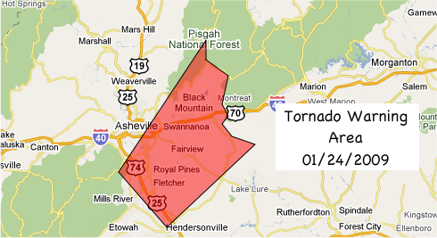
**7.02pm** Yes, I've typed 2009 instead of 2010 in several places. LOL. I'll fix the map later.


The area above was placed under a Tornado Warning by the National Weather Service for a brief time this afternoon after radar indicated conditions favored the formation of a tornado in Henderson and Buncombe Counties in western North Carolina.

I posted a radar image of the vortex on Twitter via TwitPic.


Here is the way the regional map for the GSP Office of the National Weather Service looked at the time the Tornado warning was issued:


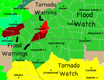
And here is the statement issued:


BULLETIN - EAS ACTIVATION REQUESTED
TORNADO WARNING
NATIONAL WEATHER SERVICE GREENVILLE-SPARTANBURG SC
523 PM EST SUN JAN 24 2010

THE NATIONAL WEATHER SERVICE IN GREENVILLE-SPARTANBURG HAS ISSUED A

* TORNADO WARNING FOR...
EASTERN BUNCOMBE COUNTY IN WESTERN NORTH CAROLINA...
NORTHEASTERN HENDERSON COUNTY IN WESTERN NORTH CAROLINA...

* UNTIL 600 PM EST

* AT 521 PM EST...NATIONAL WEATHER SERVICE DOPPLER RADAR INDICATED A
SEVERE THUNDERSTORM CAPABLE OF PRODUCING A TORNADO NEAR FLETCHER...
OR 8 MILES NORTH OF HENDERSONVILLE...MOVING NORTHEAST AT 50 MPH.

* OTHER LOCATIONS IN THE WARNING INCLUDE BUT ARE NOT LIMITED TO
SKYLAND...BILTMORE FOREST...FAIRVIEW...SWANNANOA...BLACK MOUNTAIN
AND MONTREAT

PRECAUTIONARY/PREPAREDNESS ACTIONS...

MOBILE HOMES AND VEHICLES SHOULD BE ABANDONED FOR STURDIER SHELTER.
OTHERWISE...GO TO AN INTERIOR ROOM ON THE LOWEST LEVEL OF YOUR HOME
OR PLACE OF BUSINESS. MAKE SURE THERE ARE AS MANY WALLS AND FLOORS
BETWEEN YOU AND THE OUTSIDE AS POSSIBLE.

TO REPORT TORNADOES...DAMAGING WINDS...LARGE HAIL...OR FLOODING...
THROUGH OUR AUTOMATED REPORTING SYSTEM...CALL OUR TOLL FREE NUMBER...
1 8 7 7...6 3 3...6 7 7 2.

A TORNADO WATCH REMAINS IN EFFECT UNTIL 100 AM EST MONDAY MORNING FOR
NORTHEAST GEORGIA AND CENTRAL SOUTH CAROLINA.

&&

LAT...LON 3575 8234 3571 8227 3564 8229 3561 8227
3559 8229 3556 8226 3554 8219 3533 8246
3547 8261 3580 8234
TIME...MOT...LOC 2223Z 216DEG 41KT 3545 8249

$$
07


UPDATE #1


SEVERE WEATHER STATEMENT
NATIONAL WEATHER SERVICE GREENVILLE-SPARTANBURG SC
539 PM EST SUN JAN 24 2010

NCC089-242248-
/O.CAN.KGSP.TO.W.0001.000000T0000Z-100124T2300Z/
HENDERSON NC-
539 PM EST SUN JAN 24 2010

...THE TORNADO WARNING FOR NORTHEASTERN HENDERSON COUNTY IS
CANCELLED...

THE THUNDERSTORMS SUSPECTED OF PRODUCING A TORNADO MOVED NORTHEAST
AND OUT OF HENDERSON COUNTY.

A TORNADO WATCH REMAINS IN EFFECT UNTIL 100 AM EST MONDAY MORNING FOR
NORTHEAST GEORGIA AND CENTRAL SOUTH CAROLINA.

LAT...LON 3580 8234 3575 8234 3571 8227 3564 8229
3561 8227 3559 8229 3556 8226 3554 8219
3548 8237 3546 8240 3547 8243 3555 8252
TIME...MOT...LOC 2238Z 217DEG 49KT 3558 8234

$$

NCC021-242300-
/O.CON.KGSP.TO.W.0001.000000T0000Z-100124T2300Z/
BUNCOMBE NC-
539 PM EST SUN JAN 24 2010

...A TORNADO WARNING REMAINS IN EFFECT UNTIL 600 PM EST FOR EASTERN
BUNCOMBE COUNTY...

AT 533 PM EST...NATIONAL WEATHER SERVICE DOPPLER RADAR CONTINUED TO
INDICATE A TORNADO. THIS TORNADO WAS LOCATED NEAR FAIRVIEW...OR 10
MILES SOUTHEAST OF DOWNTOWN ASHEVILLE...MOVING NORTHEAST AT 55 MPH.

OTHER LOCATIONS IN THE WARNING INCLUDE BUT ARE NOT LIMITED TO BLACK
MOUNTAIN AND MONTREAT

PRECAUTIONARY/PREPAREDNESS ACTIONS...

MOBILE HOMES AND VEHICLES SHOULD BE ABANDONED FOR STURDIER SHELTER.
OTHERWISE...GO TO AN INTERIOR ROOM ON THE LOWEST LEVEL OF YOUR HOME
OR PLACE OF BUSINESS. MAKE SURE THERE ARE AS MANY WALLS AND FLOORS
BETWEEN YOU AND THE OUTSIDE AS POSSIBLE.

A TORNADO WATCH REMAINS IN EFFECT UNTIL 100 AM EST MONDAY MORNING FOR
NORTHEAST GEORGIA AND CENTRAL SOUTH CAROLINA.

&&

LAT...LON 3580 8234 3575 8234 3571 8227 3564 8229
3561 8227 3559 8229 3556 8226 3554 8219
3548 8237 3546 8240 3547 8243 3555 8252
TIME...MOT...LOC 2238Z 217DEG 49KT 3558 8234

$$

07

UPDATE #3


SEVERE WEATHER STATEMENT
NATIONAL WEATHER SERVICE GREENVILLE-SPARTANBURG SC
548 PM EST SUN JAN 24 2010

NCC021-242258-
/O.CAN.KGSP.TO.W.0001.000000T0000Z-100124T2300Z/
BUNCOMBE NC-
548 PM EST SUN JAN 24 2010

...THE TORNADO WARNING FOR EASTERN BUNCOMBE COUNTY IS CANCELLED...

THE TORNADO HAS DISSIPATED OVER EASTERN BUNCOMBE COUNTY.

A TORNADO WATCH REMAINS IN EFFECT UNTIL 100 AM EST MONDAY MORNING FOR
NORTHEAST GEORGIA AND CENTRAL SOUTH CAROLINA.

LAT...LON 3580 8234 3575 8234 3571 8227 3564 8229
3561 8227 3559 8229 3556 8226 3554 8219
3548 8237 3546 8240 3547 8243 3555 8252
TIME...MOT...LOC 2248Z 217DEG 49KT 3569 8224

$$

07


TWITTER RESPONDS...

Also, there were a number of tweets issued by people during this event, and here are 
some of them using the word tornado and the #avlnews hashatg:


**7.06pm**

Here are a couple of storm reports from the public I found posted on the NWS website:


2010-01-24 11:00 AM
NON-TSTM WND DMG (NOT MEASURED)
LOCATION: ROBBINSVILLE, NC (GRAHAM COUNTY)
SOURCE: COUNTY OFFICIAL
REMARKS: SEVERAL TREES DOWN ON POWER LINES. MANY POWER OUTAGES REPORTED.


2010-01-24 11:00 AM
NON-TSTM WND DMG (NOT MEASURED)
LOCATION: WAYNESVILLE, NC (HAYWOOD COUNTY)
SOURCE: COUNTY OFFICIAL
REMARKS: TREES DOWN ON POWER LINES NEAR JOHNSON CREEK


2010-01-24 05:23 PM
FUNNEL CLOUD (NOT MEASURED)
LOCATION: 10 SW HENDERSONVILLE, NC (HENDERSON COUNTY)
SOURCE: PUBLIC
REMARKS: PUBLIC REPORT OF FUNNEL CLOUD AND ROARING SOUND.


2010-01-24 05:53 PM
FUNNEL CLOUD (NOT MEASURED)
LOCATION: ANDERSON, SC (ANDERSON COUNTY)
SOURCE: PUBLIC
REMARKS: PUBLIC REPORT OF FUNNEL CLOUD OVER ANDERSON.


2010-01-24 06:45 PM
FLASH FLOOD (NOT MEASURED)
LOCATION: CLEMSON, SC (PICKENS COUNTY)
SOURCE: COUNTY OFFICIAL
REMARKS: DOWNS LOOP ROAD CLOSED DUE TO FLOODING.


2010-01-24 06:45 PM
FLASH FLOOD (NOT MEASURED)
LOCATION: PICKENS, SC (PICKENS COUNTY)
SOURCE: COUNTY OFFICIAL
REMARKS: CITY LAKE ROAD CLOSED DUE TO 12 INCHES OF WATER ON ROADWAY.


**7.52am January 25, 2010**

The GSP Office of the National Weather Service now has an experimental Damage Report graphical interface that is worth checking out. Here is the archive for the time period of the storms yesterday. You can use your mouse to get more information from the icons on the map.