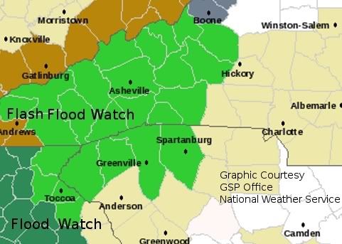
It looks like we're continuing the cycle of storms every 7 to 10 days with the approach of a rain-maker that is forecast to dump anywhere from 2 to 3 inches of rain in the mountains of western North Carolina over the next 48 hours.
If you have a Weather Radio that is equipped with SAME Technology[more info], you can receive severe weather alerts by entering your county code into the radio. For locals you can find your codes on these pages, [North Carolina], [South Carolina] and [Georgia]. Others check on this page.
162.400 | 162.425 | 162.450 | 162.475 | 162.500 | 162.525 | 162.550 |
Here is the official weather statement from the GSP Office of the National Weather Service...
FLOOD WATCH
NATIONAL WEATHER SERVICE GREENVILLE-SPARTANBURG SC
407 AM EST SAT JAN 23 2010
...HEAVY RAIN ON SUNDAY...
.MOIST SOUTHERLY FLOW INTO THE HIGHER TERRAIN OF NORTHEAST
GEORGIA AND THE WESTERN CAROLINAS...COMBINED WITH THE APPROACH OF
A STRONG COLD FRONT...WILL CAUSE HEAVY RAIN TO DEVELOP LATE
SATURDAY NIGHT. THE RAIN WILL CONTINUE UNTIL THE COLD FRONT
CROSSES THE REGION ON SUNDAY EVENING. TWO TO THREE INCHES OF
RAINFALL ARE EXPECTED...WITH THE HIGHEST AMOUNTS NEAR THE BLUE
RIDGE AND ADJACENT FOOTHILLS.
...FLASH FLOOD WATCH REMAINS IN EFFECT FROM LATE TONIGHT THROUGH
SUNDAY EVENING...
THE FLASH FLOOD WATCH CONTINUES FOR AREAS ON THE MAP BELOW:

* FROM LATE TONIGHT THROUGH SUNDAY EVENING
* TWO TO THREE INCHES OF RAINFALL ARE EXPECTED FROM LATE SATURDAY
NIGHT THROUGH SUNDAY EVENING...WITH THE HIGHEST AMOUNTS NEAR THE
BLUE RIDGE AND ADJACENT FOOTHILLS. SCATTERED THUNDERSTORMS COULD
PRODUCE LOCALLY HIGHER AMOUNTS.
* AS THE RAIN IS EXPECTED TO FALL HEAVILY AT TIMES SUNDAY
AFTERNOON...RAPID FLASH FLOODING ALONG STREAMS AND CREEKS MAY
DEVELOP. FLOODING OF LARGER RIVERS IS ALSO POSSIBLE LATER SUNDAY
OR SUNDAY NIGHT AS RUNOFF FROM THE HEAVY RAIN WORKS IT/S WAY
INTO THE RIVER SYSTEM.
PRECAUTIONARY/PREPAREDNESS ACTIONS...
A FLASH FLOOD WATCH MEANS THAT CONDITIONS MAY DEVELOP THAT LEAD
TO FLASH FLOODING. FLASH FLOODING IS A VERY DANGEROUS SITUATION.
YOU SHOULD MONITOR LATER FORECASTS AND BE PREPARED TO TAKE ACTION
SHOULD FLASH FLOOD WARNINGS BE ISSUED.


0 comments :
Post a Comment