


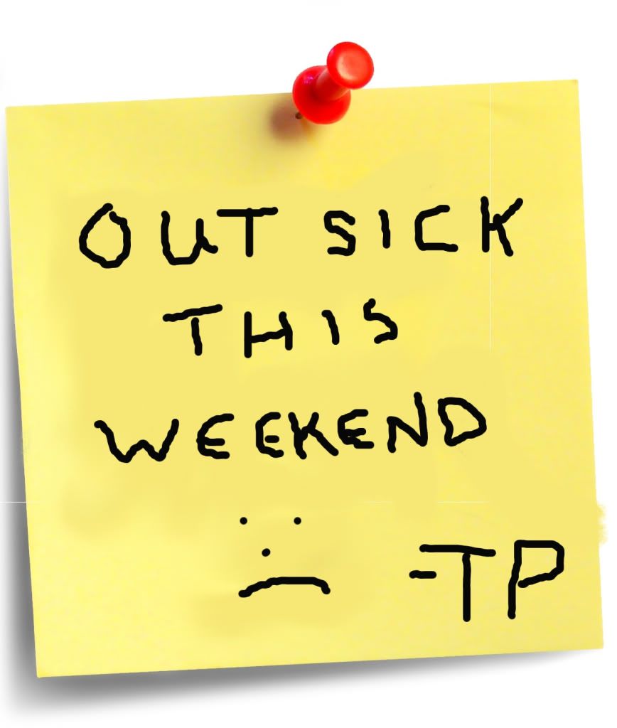
I have been fighting a bug since last Saturday, and have decided to come to a full stop this weekend in an effort to get plenty of rest and keep hydrated so I can kick its butt once and for all. I hope to be back to full speed by Monday.
Blogging the world around me.

Coverage of the meetings of the Macon County Board of County Commissioners.

Coverage of the meetings of the Franklin Town Board of Aldermen.

Coverage of the meetings of the Macon County School Board.

Photos from my photoblog.

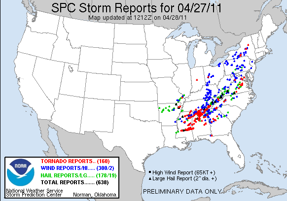
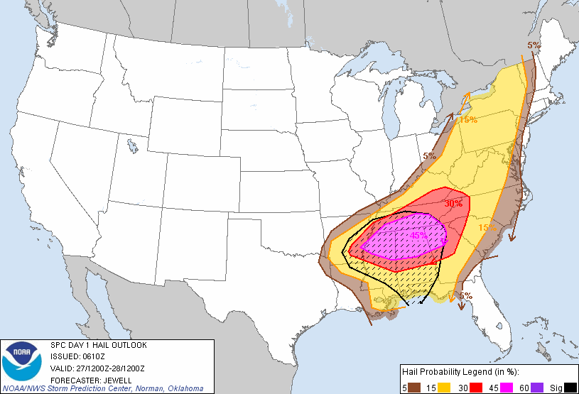
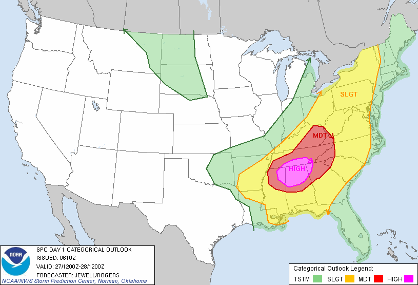
 SPC AC 271255

   DAY 1 CONVECTIVE OUTLOOK
   NWS STORM PREDICTION CENTER NORMAN OK
   0755 AM CDT WED APR 27 2011

   VALID 271300Z - 281200Z

   ...THERE IS A HIGH RISK OF SVR TSTMS TODAY INTO EARLY TONIGHT FOR NE
   MS...CENTRAL/NRN AL...NW GA...SE TN...

   ...THERE IS A MDT RISK OF SVR TSTMS SURROUNDING THE HIGH RISK...FROM
   NRN/CENTRAL MS TO SRN AL...NW GA...MIDDLE/ERN TN...WRN SC...WRN
   NC...WRN VA...AND ERN KY...

   ...THERE IS A SLGT RISK OF SVR TSTMS FROM THE N CENTRAL GULF COAST
   TO THE OH VALLEY/APPALACHIANS AND NY...

   --DANGEROUS TORNADO OUTBREAK IS EXPECTED FROM LATE MORNING INTO LATE
   EVENING ACROSS THE TN VALLEY REGION--

   ...SYNOPSIS...
   AN INTENSE MIDLEVEL SHORTWAVE TROUGH AND ASSOCIATED 100 KT 500 MB
   JET WILL PIVOT EWD FROM TX/OK THIS MORNING TO LOWER MS/TN VALLEY
   REGION BY THIS EVENING...AND CONTINUE NEWD TO THE CENTRAL
   APPALACHIANS OVERNIGHT.  THE PRIMARY SURFACE CYCLONE WILL DEVELOP
   NEWD FROM WRN AR THIS MORNING TO WRN KY/SRN INDIANA BY THIS
   EVENING...AND THEN CONTINUE NEWD TO THE LOWER GREAT LAKES OVERNIGHT.
   A TRAILING COLD FRONT AND REMNANT DRYLINE FEATURE WILL SWEEP EWD
   ACROSS THE ARKLAMISS THIS AFTERNOON...PROVIDING A FOCUS FOR SEVERE
   STORM DEVELOPMENT.  GIVEN THE PRESENCE OF VERY STRONG WINDS
   THROUGHOUT THE TROPOSPHERE AND AN INFLUX OF RICH MOISTURE FROM THE
   GULF OF MEXICO...THE ENVIRONMENT WILL BE FAVORABLE FOR A DANGEROUS
   OUTBREAK OF FAST-MOVING TORNADIC SUPERCELLS AND EMBEDDED BOW ECHOES
   TODAY INTO EARLY TONIGHT.

   ...MS/AL/TN/KY/GA AREA THROUGH TONIGHT...
   THE REMNANTS OF AN INTENSE OVERNIGHT MCS /INCLUDING EMBEDDED
   SUPERCELLS AND BOWS/ IS WEAKENING OVER NE AL AND MIDDLE TN AS OF
   SUNRISE.  OTHER ELEVATED THUNDERSTORM DEVELOPMENT IS UNDERWAY TO THE
   W FROM NE LA INTO SE AR/NRN MS.  SOME FORM OF THIS ELEVATED
   CONVECTION WILL LIKELY PERSIST THROUGH THE DAY WHILE SPREADING ENEWD
   OVER NRN MS INTO WRN/MIDDLE TN.  S OF THIS ACTIVITY AND IN THE WAKE
   OF THE EARLIER MS/AL MCS...IT APPEARS THAT THE WARM SECTOR WILL
   RECOVER QUICKLY DURING THE MORNING/EARLY AFTERNOON IN RESPONSE TO
   CLOUD BREAKS AND STRONG LOW-LEVEL SLY FLOW.  A RESERVOIR OF 70-72 F
   BOUNDARY LAYER DEWPOINTS FROM SRN LA TO SRN AL WILL SPREAD NWD IN
   THE WAKE OF THE MORNING STORMS...BENEATH THE REMNANTS OF STEEP
   MIDLEVEL LAPSE RATE PLUME SPREADING EWD FROM TX/LA.  SURFACE HEATING
   WITHIN THE MOIST WARM SECTOR WILL BOOST MLCAPE VALUES TO 2500-4000
   J/KG ALONG AND S OF THE REMNANT OUTFLOW BOUNDARY...AND REDUCE
   CONVECTIVE INHIBITION BY ABOUT MIDDAY.  THIS WILL ALLOW THE
   DEVELOPMENT OF SCATTERED-NUMEROUS WARM SECTOR SUPERCELLS ALONG
   CONFLUENCE BANDS E OF THE COLD FRONT/DRYLINE BY EARLY AFTERNOON.

   THE VERTICAL SHEAR ENVIRONMENT WILL BECOME VERY FAVORABLE FOR
   TORNADIC SUPERCELLS...CHARACTERIZED BY LONG/CURVED HODOGRAPHS WITH
   EFFECTIVE BULK SHEAR IN EXCESS OF 70 KT AND EFFECTIVE SRH OF 300-600
   M2/S2 IN THE UNSTABLE WARM SECTOR.  GIVEN THE EXPECTATION OF SEVERAL
   HOURS OF DISCRETE SUPERCELL DEVELOPMENT IN THE WAKE OF THE MORNING
   STORMS...A VERY MOIST BOUNDARY LAYER...THE STRONG INSTABILITY...AND
   INTENSE VERTICAL SHEAR...THE SCENARIO APPEARS FAVORABLE FOR MULTIPLE
   LONG-TRACK SUPERCELLS WITH THE POTENTIAL TO PRODUCE INTENSE/DAMAGING
   TORNADOES IN THE HIGH RISK AREA.

   ...AR NEWD TO THE LOWER OH VALLEY TODAY...
   ALONG THE PATH OF THE MIDLEVEL TROUGH AND SURFACE CYCLONE...THERE
   WILL BE A FOCUS FOR ADDITIONAL SEVERE THUNDERSTORM DEVELOPMENT LATER
   TODAY.  THE DEGREE OF INSTABILITY IS IN QUESTION GIVEN THE IMPACTS
   OF OVERNIGHT AND ONGOING CONVECTION FARTHER TO THE SE.  STILL...ANY
   CLOUD BREAKS WILL ALLOW DESTABILIZATION BENEATH COOL MIDLEVEL
   TEMPERATURES...IN AN ENVIRONMENT OF STRONG DEEP-LAYER SPEED SHEAR.
   DAMAGING WINDS/HAIL AND A COUPLE OF TORNADOES WILL BE POSSIBLE WITH
   ANY CLUSTERS IMMEDIATELY IN ADVANCE OF THE SURFACE LOW.

   ...UPPER OH VALLEY TONIGHT...
   THE PRIMARY SURFACE CYCLONE AND STRONG KINEMATIC PROFILES ARE
   EXPECTED TO REACH THE UPPER OH VALLEY EARLY TONIGHT.  THE MAGNITUDE
   OF WARM SECTOR INSTABILITY IS IN QUESTION GIVEN WIDESPREAD
   CONVECTION ONGOING AND EXPECTED TO THE SOUTH.  HOWEVER...VERY STRONG
   LOW-LEVEL SHEAR IN A MOIST ENVIRONMENT COULD SUPPORT A FEW TORNADOES
   WITH EMBEDDED BOWS AND SUPERCELL STRUCTURES.

   ..THOMPSON/COHEN.. 04/27/2011
 SPC AC 270610

   DAY 1 CONVECTIVE OUTLOOK CORR 1
   NWS STORM PREDICTION CENTER NORMAN OK
   0110 AM CDT WED APR 27 2011

   VALID 271200Z - 281200Z

   ...THERE IS A HIGH RISK OF SVR TSTMS OVER PORTIONS OF NRN
   MS...AL...FAR NWRN GA AND SRN MIDDLE TN...

   ...THERE IS A MDT RISK OF SVR TSTMS OVER MUCH OF CNTRL AND NRN MS
   AND AL...NWRN GA...MUCH OF TN AND KY...WRN CAROLINAS...

   ...THERE IS A SLGT RISK OF SVR TSTMS FROM THE LOWER MS VALLEY/GULF
   COAST STATES NWD TO THE CANADIAN BORDER...

   CORRECTED FOR SPELLING ERROR

   ...SYNOPSIS...
   AN UPPER TROUGH AXIS WILL BE CENTERED ACROSS THE SRN PLAINS AT 12Z
   WED...WITH A 100 KT MID LEVEL JET ACROSS N TX. THIS FEATURE WILL
   STRENGTHEN THROUGH 00Z AS IT EJECTS NEWD ACROSS THE LOWER MS AND
   INTO THE TN/OH VALLEYS DURING THE DAY. AT THE SURFACE...LOW PRESSURE
   IS FORECAST TO BE OVER W CNTRL AR AT 12Z...WITH A DEVELOPING COLD
   FRONT TRAILING SWWD INTO ERN TX. THESE FEATURES WILL MOVE RAPIDLY
   ENEWD...WITH THE SURFACE LOW NEARING SRN INDIANA BY 00Z AND A SHARP
   LOW PRESSURE TROUGH EXTENDING SWD INTO CNTRL KY...MIDDLE TN...ERN MS
   AND WRN AL.

   AHEAD OF THE FRONT...A VERY WARM AND MOIST AIR MASS WILL ALREADY BE
   IN PLACE BY MIDDAY WITH 68-72 BOUNDARY LAYER DEWPOINTS LIKELY FROM
   THE GULF COAST INTO MS/AL...AND MID TO UPPER 60S F OVER TN AND SRN
   KY WHERE SUBSTANTIAL MORNING CONVECTION WILL LIKELY BE ONGOING. WITH
   RELATIVELY COOL TEMPERATURE PROFILES ALOFT...AN EXTREMELY UNSTABLE
   ATMOSPHERE WILL RESULT ACROSS THE WARM SECTOR. WIND FIELDS
   THROUGHOUT THE TROPOSPHERE WILL STRENGTHEN WITH THE APPROACHING
   TROUGH/JET MAX...AND THE COMBINATION OF THE TWO IS EXPECTED TO
   RESULT IN A TORNADO OUTBREAK...WITH LONG-TRACKED STRONG TO VIOLENT
   TORNADOES POSSIBLE OVER THE HIGH RISK AREA.

   TO THE E...THE BROAD SLY FLOW ACROSS THE WARM SECTOR WILL EXTEND
   INTO THE MID ATLANTIC REGION...WITH A SECONDARY MOIST PLUME OFF THE
   ATLANTIC NWD INTO THE CAROLINAS AND WRN VA BY AFTERNOON.

   --- AN OUTBREAK OF TORNADOES AND DAMAGING WINDS IS EXPECTED TODAY
   THROUGH EVENING OVER PORTIONS OF NRN MS...NRN AL...TN AND KY. ---

   ...LOWER MS VALLEY INTO TN/OH VALLEYS...
   A COMPLICATED FORECAST SCENARIO WILL UNFOLD TODAY...BEGINNING RATHER
   EARLY IN THE PERIOD OVER SRN AND ERN AR AND NRN LA. MODELS ARE IN
   RELATIVELY GOOD AGREEMENT WITH THE PLACEMENT OF THE SURFACE LOW OVER
   AR BETWEEN 12-15Z...THEN DEVELOPING IT NEWD ACROSS TN/KY BY 00Z.
   NUMEROUS THUNDERSTORMS WILL BE ONGOING...AND SOME WILL BE
   SEVERE...FROM NRN LA/SRN AR EWD ACROSS NRN MS...WRN AND MIDDLE TN
   AND KY. DESPITE TIME OF DAY...PRESENCE OF RICH LOW LEVEL MOISTURE
   WILL RESULT IN LITTLE CAPPING AND SURFACE BASED EFFECTIVE PARCELS.
   THUS...A TORNADO AND DAMAGING WIND THREAT WILL BE PRESENT WITH THIS
   ACTIVITY.

   SOUTH OF THE ONGOING ACTIVITY...STRONG DAYTIME HEATING WILL OCCUR.
   WITH BOUNDARY LAYER DEWPOINTS IN THE LOW 70S F...THIS WILL CREATE
   STRONG TO EXTREME INSTABILITY OVER MS AND AL NWD TO THE ONGOING
   CONVECTION. A CAPPING INVERSION WILL LIKELY KEEP MUCH OF THE WARM
   SECTOR S OF THE EARLY STORMS CAPPED...ALLOWING A BUILD UP OF
   INSTABILITY TO BE RELEASED WHEN LARGE SCALE FORCING ARRIVES DURING
   THE AFTERNOON ALONG THE COLD FRONT AND ESPECIALLY NEAR THE
   FRONT/OUTFLOW BOUNDARY INTERSECTION. THE RESULT WILL BE FAST MOVING
   TORNADIC SUPERCELLS CAPABLE OF STRONG TO VIOLENT TORNADOES. GIVEN
   THE FAST STORM MOTIONS AND RELATIVELY WIDE WARM SECTOR...SOME
   TORNADOES COULD BE LONG LIVED. THE GREATEST THREAT FOR THESE TYPES
   OF STORMS WILL BE OVER THE HIGH RISK AREA...OVER NRN MS AND
   AL...INTO EXTREME NWRN GA AND SRN MIDDLE TN. THIS ACTIVITY WILL
   PERSIST TO THE E...BUT CELLS MAY EVENTUALLY MERGE INTO MORE OF A
   QLCS STRUCTURE CAPABLE OF PARTICULARLY DAMAGING WINDS AND A FEW
   TORNADOES.

   ...WRN NC/VA...
   A CONDITIONAL SEVERE THREAT WILL EXIST BY LATE AFTERNOON OVER WRN
   NC/VA.  STRONG  HEATING WILL RESULT IN STEEP LOW LEVEL LAPSE
   RATES...BUT FORECAST SOUNDINGS SHOW A CAPPING INVERSION AROUND 700
   MB...WHICH SHOULD KEEP THE AIR MASS CAPPED. HOWEVER...MOISTURE
   ADVECTION...AS WELL AS SELY UPSLOPE FLOW MAY RESULT IN ISOLATED
   THUNDERSTORMS DURING THE AFTERNOON OVER THE HIGHER TERRAIN. WIND
   PROFILES WOULD FAVOR SUPERCELLS...CAPABLE OF PRODUCING TORNADOES
   HAIL AND WIND. WILL MAINTAIN LOW PROBABILITIES FOR THE DAYTIME
   CONVECTION.

   ..JEWELL.. 04/27/2011
| 8:30 AM | Appropriations (House) [Live Audio] PLEASE REMEMBER TO BRING YOUR COPY OF THE BILL AND MONEY REPORT TO THE MEETING. COPIES WILL NOT BE AVAILABLE AT THE MEETING Appropriations Act of 2011. (H200) | 643 LOB |
| 9:00 AM | Rules and Operations of the Senate -- CORRECTED (Senate) | 1027 LB |
| 10:00 AM | Insurance (Senate) | 1027 LB |
| 10:00 AM | Education/Higher Education (Senate) [Live Audio] | 544 LOB |
| 10:00 AM | Sen. F. McKissick (Time Change) [Live Audio] | Press Room LB |
| 11:00 AM | Transportation (Senate) | 1027 LB |
| 11:00 AM | Health Care -- CORRECTED (Senate) [Live Audio] | 544 LOB |
| 12:00 NOON | Mental Health & Youth Services (Senate) | 414 LOB |
| 12:15 PM | Session Convenes (House) [Live Audio] No bills are on the calendar | House |
| 1:00 PM | Finance (Senate) [Live Audio] Level Playing Field/Local Gov't Competition. (H129) | 544 LOB |
| 3:00 PM | Session Convenes (Senate) [Live Audio] PUBLIC BILLS SECOND READING SB 404 (Id H 391) Brock DEPT. OF ADMIN/PROCUREMENT MODERNIZATION.-AB 3/24 Program Evaluation 4/26 Fav SB 463 Mansfield 2nd Ed. ACCOUNTABILITY FOR TAXPAYER INVESTMENT ACT. Com Sub 3/31 Program Eval. 4/26 Unfav bill; Program Eval. Com Sub Adopted; (Chgs title) SB 479 Tillman, Preston, Soucek TESTING IN THE PUBLIC SCHOOLS. 4/4 Ed/Higher Ed.; if Fav Appro./Base Bud. 4/14 Fav; rerefer Appro./Base Bud. 4/26 W/D Appro./Base Bud.; Cal 4/27 SB 487 Stein, Vaughan, Newton DISPUTED EARNEST MONEY/ATTORNEYS DEPOSIT. 4/4 Judiciary I 4/26 Fav SB 493 Daniel, Jackson 2nd Ed. CODIFY NC CENTURY FARMS PROGRAM IN DACS. Com Sub 4/4 Ag./Envir./Nat Res. 4/26 Unfav bill; Ag./Envir./Nat Res. Com Sub Adopted SB 501 (Id H 529) Rouzer, Jackson 2nd Ed. SWINE HOUSE RENOVATIONS/SITE LIMITS. Com Sub 4/5 Ag./Envir./Nat Res. 4/26 Unfav bill; Ag./Envir./Nat Res. Com Sub Adopted SB 514 Brunstetter NUTRIENT MANAGEMENT PLAN ONLY FOR NSW. 4/6 Ag./Envir./Nat Res. 4/26 Fav THIRD READING SB 433 (Id H 580) Hartsell 2nd Ed. LOCAL HUMAN SERVICES ADMINISTRATION. Com Sub 3/29 Health Care4/6 Unfav bill; Health Care Com Sub Adopted4/7 W/D Cal; Cal 4/11 4/11 W/D Cal; Cal 4/13 4/13 W/D Cal; Cal 4/14 4/14 W/D Cal; Cal 4/19 4/19 W/D Cal; Cal 4/20 4/20 Hartsell Amd. No. 1 Adopted; Purcell Amd No. 2 Withdrawn; D. Berger Amd No. 3 Failed; Passed 2nd Rdg 4/21 W/D Cal; Cal 4/27 | Senate |

| 15 MINUTES AFTER SESSION | Judiciary Subcommittee B (House) | 421 LOB |
| 8:00 AM | Finance -- CORRECTED (House) [Live Audio] | 544 LOB |
| 10:00 AM | Judiciary I -- CANCELLED (Senate) Judiciary I is cancelled Allow Juvenile Record/Risk Determination/Bond. (S135) Confidentiality/Investigative Info/Optometry. (S349) Revise Probate Code. (S432) Repeal Matching Funds. (S459) Buyer Choice/Title Insurer & Settlement Agent. (S518) Repeal Rule in Dumpor's Case. (S521) Personnel Records Technical Changes. (S554) Clarify Trusts as Beneficiaries in POD Accts. (S568) Clarify Use of Position. (S620) | 1027 LB |
| 10:00 AM | Judiciary II (Senate) | 1124 LB |
| 10:00 AM | Education (House) [Live Audio] | 643 LOB |
| 10:00 AM | Health and Human Services (House) | 1228 LB |
| 11:00 AM | Agriculture/Environment/Natural Resources (Senate) [Live Audio] Landowner Protection Act. (S374) ETJ/Clarify Definition of Bona Fide Farm. (S380) Hunting Protection Act. (S429) REPS Credits at Cleanfields Parks. (S484) Swine House Renovations/Site Limits. (S501) Nutrient Management Plan Only For NSW. (S514) Clarify Water & Well Rights/Private Property. (S676) Codify NC Century Farms Program in DACS. (S493) | 544 LOB |
| 11:00 AM | Commerce -- CORRECTED (Senate) | 1027 LB |
| 11:00 AM | Rep. Pierce [Live Audio] Ref: Ex-Offfender Lobby Day | Press Room LB |
| 12:00 PM | Sen. Nesbitt [Live Audio] | Press Room LB |
| 12:00 NOON | State and Local Government -- CORRECTED (Senate) | 1124 LB |
| 12:00 NOON | Program Evaluation (Senate) | 421 LOB |
| 12:00 NOON | Transportation (House) [Live Audio] | 643 LOB |
| 1:00 PM | Insurance (House) | 1228/1327 |
| 1:00 PM | Agriculture -- CANCELLED (House) [Live Audio] | 643 LOB |
| 1:00 PM | Sen. P. Berger & Rep. Tillis [Live Audio] | Press Room LB |
| 2:00 PM | Session Convenes (House) [Live Audio] | House |
| 3:00 PM | Session Convenes (Senate) [Live Audio] | Senate |


CROWD FUNDING
If you're of a mind, and can afford it, a dollar a month (or more) from enough people will make a huge difference in improving the quality of coverage of local meetings and events, as well as allowing remote weather stations and weather cams to be deployed throughout the county that you will be able to access online.
Currently, 20 people have pledged $99 a month. This is a tremendous help. Please visit www.patreon.com/MaconMedia for more information on how to contribute.
Businesses can underwrite this coverage by day sponsorships, surplus equipment donations, etc. Inquire at editor@maconmedia.com for more information.


