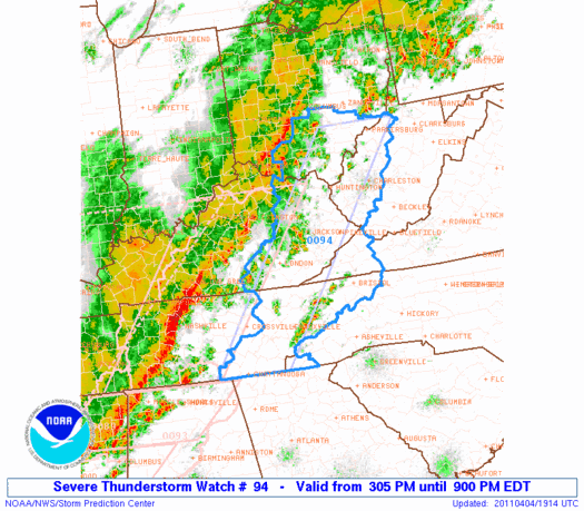
Be on the lookout for severe weather overnight tonight in western North Carolina and into the Piedmont in the early morning hours. I'll be covering the Town Board of Aldermen meeting tonight in franklin, and will not be able to keep an eye on this storm from 7ish to 9ish tonight.
You should probably stock up on extra batteries for flashlights and make sure your NOAA All Hazards Radio has extra batteries as well. It looks like it will be a long night. If the lightning is not shrouded in rain, I intend on trying to capture some shots of that and perhaps grab some audio of the thunder as well.
You can receive updated information via GSP Office of the National Weather Service, if you live outside WNC and Upstate SC, check the National Page and click on the map for information where you live.
Here is the text of the Severe Thunderstorm Watch #094 that was issued along with the above graphic:
URGENT - IMMEDIATE BROADCAST REQUESTED
   SEVERE THUNDERSTORM WATCH NUMBER 94
   NWS STORM PREDICTION CENTER NORMAN OK
   305 PM EDT MON APR 4 2011

   THE NWS STORM PREDICTION CENTER HAS ISSUED A
   SEVERE THUNDERSTORM WATCH FOR PORTIONS OF

          EASTERN KENTUCKY
          EXTREME WESTERN NORTH CAROLINA
          SOUTHEAST OHIO
          EASTERN TENNESSEE
          EXTREME WESTERN VIRGINIA
          WESTERN WEST VIRGINIA

   EFFECTIVE THIS MONDAY AFTERNOON AND EVENING FROM 305 PM UNTIL 900
   PM EDT.

   HAIL TO 0.5 INCH IN DIAMETER...THUNDERSTORM WIND GUSTS TO 70
   MPH...AND DANGEROUS LIGHTNING ARE POSSIBLE IN THESE AREAS.

   THE SEVERE THUNDERSTORM WATCH AREA IS APPROXIMATELY ALONG AND 50
   STATUTE MILES EAST AND WEST OF A LINE FROM 20 MILES NORTHWEST OF
   PARKERSBURG WEST VIRGINIA TO 65 MILES SOUTH OF CROSSVILLE
   TENNESSEE.  FOR A COMPLETE DEPICTION OF THE WATCH SEE THE
   ASSOCIATED WATCH OUTLINE UPDATE (WOUS64 KWNS WOU4).

   REMEMBER...A SEVERE THUNDERSTORM WATCH MEANS CONDITIONS ARE
   FAVORABLE FOR SEVERE THUNDERSTORMS IN AND CLOSE TO THE WATCH
   AREA. PERSONS IN THESE AREAS SHOULD BE ON THE LOOKOUT FOR
   THREATENING WEATHER CONDITIONS AND LISTEN FOR LATER STATEMENTS
   AND POSSIBLE WARNINGS. SEVERE THUNDERSTORMS CAN AND OCCASIONALLY
   DO PRODUCE TORNADOES.

   OTHER WATCH INFORMATION...CONTINUE...WW 89...WW 90...WW 91...WW
   92...WW 93...

   DISCUSSION...WELL-DEVELOPED SQUALL LINE WILL CONTINUE TO SURGE EWD
   THROUGH THE AFTERNOON/EVENING WITH A CONTINUED RISK FOR DAMAGING
   WINDS.  GRADUAL BOUNDARY LAYER MOISTENING AND SOME CLOUD BREAKS WILL
   SUPPORT WEAK SURFACE-BASED INSTABILITY...WHILE STRONG LOW-MIDLEVEL
   FLOW WILL SUPPORT DAMAGING WINDS WITH MOMENTUM TRANSFER TO THE
   SURFACE IN BOWING SEGMENTS.

   AVIATION...A FEW SEVERE THUNDERSTORMS WITH HAIL SURFACE AND ALOFT
   TO 0.5 INCH. EXTREME TURBULENCE AND SURFACE WIND GUSTS TO 60
   KNOTS. A FEW CUMULONIMBI WITH MAXIMUM TOPS TO 450. MEAN STORM
   MOTION VECTOR 26055.


   ...THOMPSON


0 comments :
Post a Comment