


Outlook
A clipper system will bring more mountain snow (mainly in the higher elevations) through this morning, with a few rain showers possible elsewhere. After that system exits, dry and cool air will settle over the area for the rest of the weekend. A warm and wet pattern is expected to return early next week. Dry high pressure will return by late Thursday.
The USFS Plan Revision Open House Scheduled for Franklin
An open house to allow members of the community to see and comment on the latest efforts of planning team members to revise the Master Plan for the Nantahala and Pisgah National Forests will be held at Tartan Hall on March 24th from 5:30pm to 8:00pm. An overview of the plan will be shared at 6pm. [LINK]
Agenda for March 2020 Town Council Meeting Released
Copies of the public agenda and the agenda packet for the March 2020 meeting of the Franklin Town Council have been published. [LINK]
Recent Meeting Videos Delayed
The video editing computer is down again, so videos of past meetings will take longer to process. I apologize for the delay.
Public Safety Log
(this section is temporarily deprecated until I get caught up with videos from past meetings.
THREE DAY GFS FORECAST
This animated image shows a forecast of precipitation, air pressure and thickness level (cold-air damming) for three days in six-hour increments.
Green, Yellow, and Red indicate rain. Orange and Purple Indicate Freezing Rain or other freezing precipitation. Blue indicates snow.

The next one shows the forecast for rain in 24hour totals over the next few days.

And this one shows the forecast for 24-hour snowfall totals over the same time period.

WEATHER SPONSOR

Adams Products, a Division of Oldcastle is underwriting the daily weather briefing & public safety updates for the month.
Open 7:30 AM to 4:00 PM, M-F, located at 895 Hickory Knoll Road, Franklin, NC. Visit our Facebook page at:
https://www.facebook.com/Adams.Oldcastle.Franklin.NC/
All your masonry needs are available. Our phone number is 828.524.8545, the public is welcome, we’ll help you with your next project.
Weather Hazards
The National Weather Service is calling for more snow showers today, mainly above 3500 feet. Be careful on area roadways and don't treat them like racetracks.
Winter Weather Advisory
URGENT - WINTER WEATHER MESSAGE
National Weather Service Greenville-Spartanburg SC
400 AM EST Sat Feb 29 2020
...SNOW SHOWERS ACROSS THE NORTH CAROLINA MOUNTAINS ENDING LATE THIS MORNING...
.A passing upper-level disturbance will support continued snow showers, heavy at times, across mountains through the morning hours. The greatest accumulations will occur along the higher ridge tops, especially in and around the Great Smoky Mountains and along the North Carolina/Tennessee border.
...WINTER WEATHER ADVISORY REMAINS IN EFFECT UNTIL NOON EST TODAY ABOVE 3500 FEET...
* WHAT...Snow. Additional snow accumulations of up to one inch. Snowfall rates of one to two inches per hour are possible in heavier bands.
* WHERE...Southern Jackson and Macon Counties.
* WHEN...Until noon EST today.
* IMPACTS...Slippery road conditions with reduced visibility at times.
PRECAUTIONARY/PREPAREDNESS ACTIONS...
Slow down and use caution while traveling.
Please report snow and ice accumulations by calling the National Weather Service toll free at...1...800...2 6 7...8 1 0 1. Leave a message with your observation and the specific location where it occurred. You can also post your report to National Weather Service Greenville Spartanburg Facebook or tweet your report using hashtag #nwsgsp.
Stay tuned to NOAA Weather Radio or your favorite source of weather information for the latest updates. Additional details can be found at www.weather.gov/gsp.
CROWDFUNDING OR DAY SPONSORSHIP OPPORTUNITIES
If you receive value from what Macon Media provides to the community, please consider becoming a supporter and contribute at least a dollar a month. Those who support Macon Media with at least a dollar a month receive early access to video of some events and meetings before they are made public on the website. Videos and news involving public safety are not subject to early access.
Or, if you prefer Pay Pal, try PayPal.me/MaconMedia
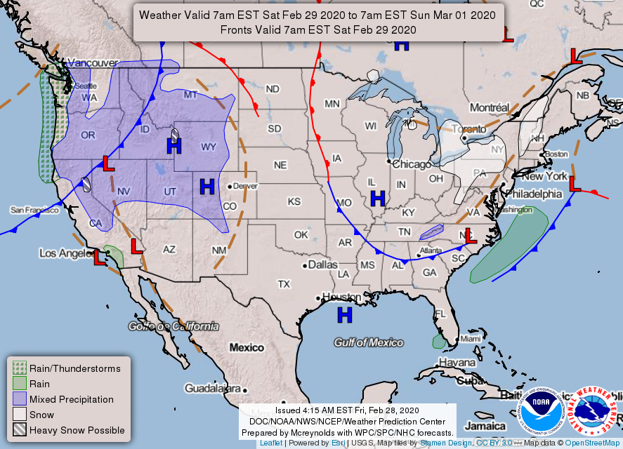
WEATHER FORECAST MAPS
Forecast maps for 7 am, 1 pm, and 7 pm.
[click on any image in this article to enlarge]


FRANKLIN AREA FORECAST
Today
A 20 percent chance of snow showers before 8am. Partly sunny, then gradually becoming sunny, with highs in the lower 40s. WInds out of the northwest 5 to 10 mph, with gusts as high as 20 mph.
Tonight
Clear, with lows in the lower 20s. Light and variable winds.
Sunday
Increasing clouds, with highs near 60. Calm winds in the morning increasing to come out of the southwest around 5 mph in the afternoon.
Sunday Night
Mostly cloudy, with lows in the upper 30s. Calm winds.
Monday
Rain likely, mainly in the afternoon. Cloudy, with highs in the low-to-mid 50s. The chance of precipitation is 70%.
Monday Night
Rain. Lows in the mid-40s. The chance of precipitation is 80%.
OTTO AREA FORECAST
Today
A 20 percent chance of snow showers before 8am. Partly sunny, then gradually becoming sunny, with highs in the lower 40s. Winds out of the northwest 10 to 15 mph, with gusts as high as 25 mph.
Tonight
Clear, with lows in the mid-20s. Winds out of the north 3 to 5 mph.
Sunday
Increasing clouds, with highs in the upper 50s. Calm winds in the morning increasing to come out of the southwest around 5 mph in the afternoon.
Sunday Night
Mostly cloudy, with lows around 40. Light winds out of the south.
Monday
Rain likely, mainly in the afternoon. Cloudy, with highs in the low-to-mid 50s. The chance of precipitation is 70%.
Monday Night
Rain. Lows in the mid-40s. The chance of precipitation is 90%.
HIGHLANDS PLATEAU FORECAST
Today
A 20 percent chance of snow showers before 8am. Partly sunny, then gradually becoming sunny, with highs near the mid-30s. Winds out of the northwest 10 to 15 mph, with gusts as high as 30 mph.
Tonight
Clear, with lows in the lower 20s. Winds out of the northwest 5 to 10 mph.
Sunday
Increasing clouds, with highs near 50. Winds out of the northwest around 5 mph becoming by noon.
Sunday Night
Mostly cloudy, with lows in the mid-30s. Winds out of the southwest around 5 mph.
Monday
Rain, mainly in the afternoon. Highs in the mid-40s. The chance of precipitation is 80%.
Monday Night
Rain. Lows near 40. The chance of precipitation is 80%.
NANTAHALA AREA FORECAST
Today
A 30 percent chance of snow showers, mainly before 8am. Mostly cloudy through midmorning, then gradual clearing, with highs in the mid-to-upper 30s. Winds out of the northwest around 10 mph, with gusts as high as 25 mph. New snow accumulation of less than a half-inch possible.
Tonight
Clear, with lows in the lower 20s. Winds out of the northwest around 5 mph becoming calm in the evening.
Sunday
Increasing clouds, with highs in the mid-50s. Calm winds in the morning increasing to come out of the southwest around 5 mph in the afternoon.
Sunday Night
Mostly cloudy, with lows in the upper 30s. Calm winds becoming south around 5 mph by the middle of the evening.
Monday
Rain likely, mainly in the afternoon. Cloudy, with highs near 50. The chance of precipitation is 70%.
Monday Night
Rain. Lows in the mid-40s. The chance of precipitation is 90%.
Published at 5:00am on Saturday, February 29, 2020


