


Outlook
Temperatures will remain above normal ahead of a slow-moving cold front which will cross the forecast area by Thursday night. Expect widespread rain ahead of the front, and the potential for heavy rainfall is high. Drier and cooler air will return to the region Friday and remain into Saturday. There is potential for some snow on the backside of the front, depending on how much moisture is available.
Franklin Town Council Meeting
The Franklin Town Council met Monday night in the lower level of the town hall. Details and video that was streamed live during the meeting are on the website. [LINK]
Segments cut from the meeting will be posted over the next several days.
Public Safety Log
Today's log is available and will be updated as needed. [LINK]
Yesterday's log is also online. [LINK]
THREE DAY GFS FORECAST
This animated image shows a forecast of precipitation, air pressure and thickness level (cold-air damming) for three days in six-hour increments.
Green, Yellow, and Red indicate rain. Orange and Purple Indicate Freezing Rain or other freezing precipitation. Blue indicates snow.

Here is a look at the forecast 24-hour rainfall totals over the next seveal days:

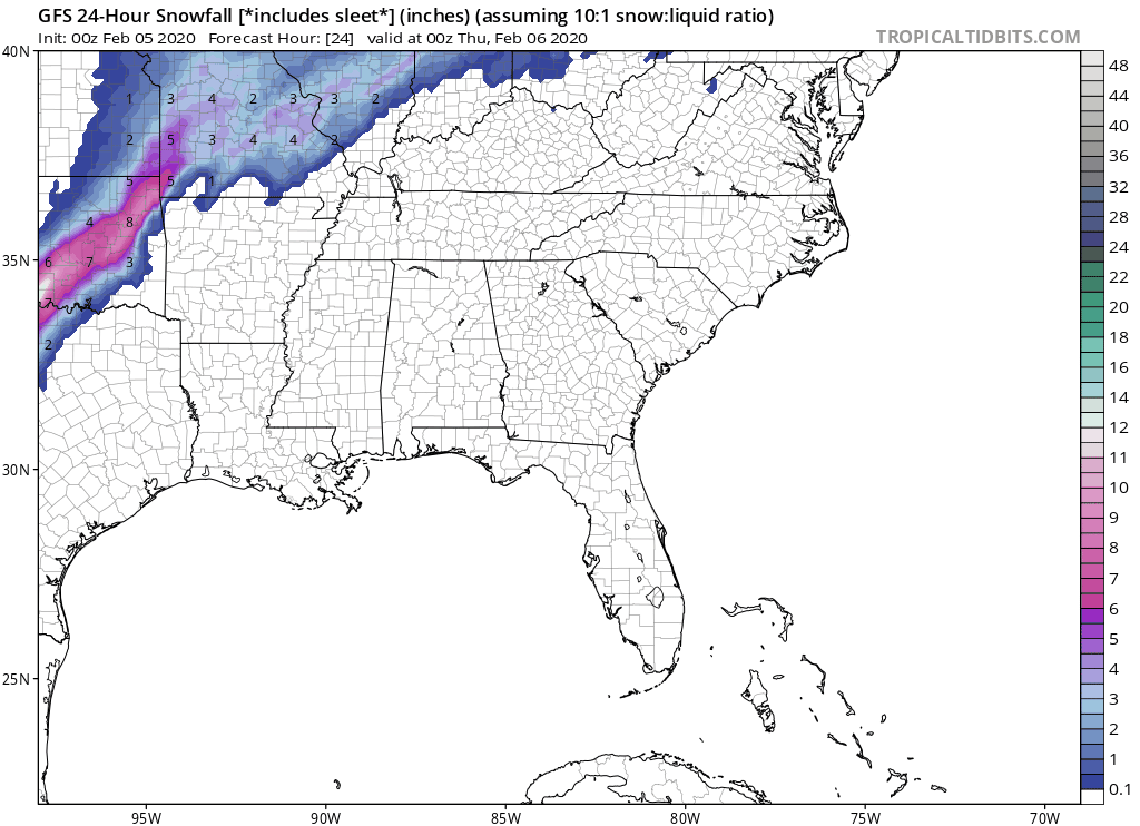
And here is a look at 24-hour snowfall forecast amounts should enough moisture remain after the front passes through the region. The maps aren't accurate enough to show that most of the snow will be above 3500 feet. Snowfall levels could fall to the valleys on Saturday should temperatures remain low and enough moisture is present. Be sure to keep an eye on your favorite weather apps or local weather people.
WEATHER SPONSOR

Adams Products, a Division of Oldcastle is underwriting the daily weather briefing & public safety updates for the month.
Open 7:30 AM to 4:00 PM, M-F, located at 895 Hickory Knoll Road, Franklin, NC. Visit our Facebook page at:
https://www.facebook.com/Adams.Oldcastle.Franklin.NC/
All your masonry needs are available. Our phone number is 828.524.8545, the public is welcome, we’ll help you with your next project.
Weather Hazards
During this rain event over the next couple of days, please remember to turn on your headlights when driving so other motorists can see you and slow down a little. a little to avoid hydroplaning.
A slow-moving cold front will bring deep moisture across the western Carolinas and northeast Georgia on Wednesday and Thursday. Periods of heavy rain are possible ahead and along the front beginning Wednesday morning and continuing Thursday afternoon, with the heaviest rain expected late Wednesday night and Thursday. Embedded thunderstorms may also bring heavy downpours and gusty winds. Enough rain may fall to raise the potential for flooding along creeks, streams, and low- lying areas. Further developments will determine if and where a Flood Watch would be issued.
CROWDFUNDING OR DAY SPONSORSHIP OPPORTUNITIES
If you receive value from what Macon Media provides to the community, please consider becoming a supporter and contribute at least a dollar a month. Those who support Macon Media with at least a dollar a month receive early access to video of some events and meetings before they are made public on the website. Videos and news involving public safety are not subject to early access.
Or, if you prefer Pay Pal, try PayPal.me/MaconMedia
WEATHER FORECAST MAPS
Forecast maps for 7 am, 1 pm, and 7 pm.
[click on any image in this article to enlarge]


FRANKLIN AREA FORECAST
Today
Showers likely. Patchy fog before noon. Otherwise, cloudy, with highs in the mid-60s. Winds out of the southeast 5 to 10 mph. The chance of precipitation is 70%. New precipitation amounts between a quarter and half of an inch possible.
Tonight
Showers. The rain could be heavy at times. Patchy fog after 8pm. Lows in the mid-50s. WInds out of the south 5 to 10 mph, with gusts as high as 30 mph. The chance of precipitation is 100%. New precipitation amounts between three quarters and one inch possible.
Thursday
Showers and possibly a thunderstorm. Some of the storms could produce heavy rainfall. Highs in the mid-60s. Winds out of the southwest 3 to 6 mph. The chance of precipitation is 100%. New precipitation amounts between 1 and 2 inches possible.
Thursday Night
Showers, mainly before midnight. Lows in the mid-30s. Winds out of the southwest 3 to 8 mph. The chance of precipitation is 80%.
Friday
A chance of rain and snow showers before 10am, then a slight chance of rain showers between 10am and 11am. Partly sunny, with highs in the mid-40s. The chance of precipitation is 30%.
Friday Night
Partly cloudy, with lows around 30.
Saturday
A 30 percent chance of showers after 1pm. Mostly cloudy, with highs in the upper 40s.
Saturday Night
A chance of rain and snow showers before 3am, then a chance of snow showers between 3am and 5am. Mostly cloudy, with lows around 30. The chance of precipitation is 40%.
OTTO AREA FORECAST
Today
Showers. Patchy fog in the afternoon hours. Highs in the mid-60s. Winds out of the southwest 5 to 10 mph. The chance of precipitation is 80%. New precipitation amounts between a quarter and half of an inch possible.
Tonight
Showers. The rain could be heavy at times. Patchy fog after 8pm. Lows in the mid-to-upper 50s. Winds out of the south 5 to 10 mph, with gusts as high as 30 mph. The chance of precipitation is 100%. New precipitation amounts between 1 and 2 inches possible.
Thursday
Showers and possibly a thunderstorm. Some of the storms could produce heavy rainfall. Highs in the mid-60s. Winds out of the southwest 5 to 10 mph. The chance of precipitation is 100%. New precipitation amounts between 1 and 2 inches possible.
Thursday Night
Showers, mainly before 1am. Lows in the mid-to-upper 30s. Winds out of the west 5 to 10 mph, with gusts as high as 20 mph. The chance of precipitation is 90%.
Friday
A 20 percent chance of showers before 11am. Mostly sunny, with highs in the mid-40s.
Friday Night
Partly cloudy, with lows around freezing.
Saturday
A 30 percent chance of showers after 1pm. Mostly cloudy, with highs in the upper 40s.
Saturday Night
A chance of rain and snow showers before 4am, then a chance of snow showers between 4am and 6am. Mostly cloudy, with lows around 30. The chance of precipitation is 40%.
HIGHLANDS PLATEAU FORECAST
Today
Showers. Patchy fog before 4pm. Highs in the mid-50s. Winds out of the southwest 10 to 15 mph. The chance of precipitation is 80%. New precipitation amounts between a half and three-quarters of an inch possible.
Tonight
Showers. The rain could be heavy at times. Patchy fog. Lows in the low-to-mid 50s. Breezy, with winds out of the south 15 to 20 mph, with gusts as high as 30 mph. The chance of precipitation is 100%. New precipitation amounts between 1 and 2 inches possible.
Thursday
Showers and possibly a thunderstorm. Some of the storms could produce heavy rainfall. Highs in the mid-50s. Winds out of the southwest 15 to 20 mph, with gusts as high as 30 mph. The chance of precipitation is 100%. New rainfall amounts between 3 and 4 inches possible.
Thursday Night
Rain before 8pm, then showers, mainly between 8pm and midnight. Lows in the mid-30s. Winds out of the southwest 15 to 20 mph, with gusts as high as 30 mph. The chance of precipitation is 90%.
Friday
A slight chance of rain and snow showers before 9am. Mostly sunny, with highs in the mid-to-upper 30s. Chance of precipitation is 20%.
Friday Night
Mostly clear, with lows in the mid-20s.
Saturday
A 30 percent chance of showers after 1pm. Mostly cloudy, with highs near 40.
Saturday Night
A chance of rain and snow showers before 8pm, then a chance of snow showers between 8pm and 5am. Mostly cloudy, with lows in the upper 20s. The chance of precipitation is 40%.
NANTAHALA AREA FORECAST
Today
Showers. The rain could be heavy at times. Patchy fog before 3pm. Highs near 60. Winds out of the southwest 5 to 10 mph, with gusts as high as 25 mph. The chance of precipitation is 90%. New precipitation amounts between three-quarters and one inch possible.
Tonight
Showers. The rain could be heavy at times. Patchy fog after 9pm. Lows in the mid-50s. Winds out of the south 10 to 15 mph, with gusts as high as 40 mph. The chance of precipitation is 100%. New precipitation amounts between 1 and 2 inches possible.
Thursday
Showers and possibly a thunderstorm. Some of the storms could produce heavy rainfall. Highs near 60. Winds out of the southwest 5 to 10 mph, with gusts as high as 25 mph. The chance of precipitation is 100%. New precipitation amounts between 1 and 2 inches possible.
Thursday Night
Showers, mainly before 2am. Lows around freezing. Winds out of the southwest 5 to 10 mph, with gusts as high as 25 mph. The chance of precipitation is 90%.
Friday
A chance of rain and snow showers before 1pm, then a slight chance of rain showers after 3pm. Partly sunny, with highs near 40. The chance of precipitation is 30%.
Friday Night
Partly cloudy, with lows around 30.
Saturday
A 30 percent chance of showers after noon. Mostly cloudy, with highs in the mid-40s.
Saturday Night
A chance of rain and snow showers before 4am, then a chance of snow showers between 4am and 6am. Mostly cloudy, with lows in the upper 20s. The chance of precipitation is 40%.
Published at 5:00am on Wednesday, February 5, 2020


0 comments :
Post a Comment