


 It looks like I may be getting 1 to 3 inches of snow today and tonight!!!
This is the kind of winter I enjoy...except for the part of having no power and worrying whether or not certain trees are gonna lose a limb or fall on my house.
As always, keep your ears peeled to local radio and TV broadcasts with updates as to the progress of the storm, and visit the National Weather Service on the Internet for official forecasts, watches and advisories.
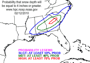
The graphics above and below are not in error. The bulk of the snow storm is expected to hit south of me in the midlands of South Carolina instead of the areas to the north and east of me...as is more common in the winter. And just think, we have 4 to 8 more weeks in which we can reasonably expect some snow to fall in my area. This winter isn't quite over yet!!!

Methinks that maybe senator Demint of South Carolina might be on to something when he said it was going to snow until Al Gore said, "Uncle!" The next few winters are going to be fun as the weather continues to get colder and the enviro-whackos continue to get shriller in their attempt to say that the snow and cold is caused by, wait for it, wait for it...Global Warming!
From the Hydrometeorological Prediction Center...
STORM SUMMARY NUMBER 3 FOR DEEP SOUTH SNOWSTORM
NWS HYDROMETEOROLOGICAL PREDICTION CENTER CAMP SPRINGS MD
300 AM CST FRI FEB 12 2010
...RARE WINTER STORM IN PROGRESS FOR THE DEEP SOUTH...
WINTER STORM WARNINGS ARE IN EFFECT FROM NORTHEAST TEXAS EASTWARD
THROUGH MISSISSIPPI AND EXTENDING INTO WESTERN GEORGIA...INCLUDING
PARTS OF THE FLORIDA PANHANDLE. WINTER STORM WATCHES ARE IN EFFECT
FROM EASTERN GEORGIA INTO SOUTHEAST NORTH CAROLINA.
FOR A DETAILED GRAPHICAL DEPICTION OF THE LATEST
WATCHES...WARNINGS AND ADVISORIES...PLEASE SEE WWW.WEATHER.GOV
AT 300 AM CST...AN AREA OF LOW PRESSURE WITH A CENTRAL PRESSURE OF
1002 MB...29.59 INCHES...WAS LOCATED 150 MILES SOUTHWEST OF NEW
ORLEANS AND IS MOVING EASTWARD AT ROUGHLY 20 MPH. NATIONAL WEATHER
SERVICE DOPPLER RADAR INDICATED A SHIELD OF MODERATE TO
OCCASIONALLY HEAVY RAINFALL ACROSS SOUTHEAST TEXAS AND EXTENDING
EASTWARD ACROSS THE CENTRAL GULF COAST. SNOWFALL HAS BEEN OBSERVED
OVER NORTHEAST TEXAS...SOUTHERN ARKANSAS...NORTHERN
LOUISIANA...CENTRAL MISSISSIPPI...AND AS FAR EAST AS WEST-CENTRAL
ALABAMA.
...SELECTED STORM TOTAL SNOWFALL IN INCHES FROM 1200 AM CST THU
FEB 11 THROUGH 300 AM CST FRI FEB 12...
...ARKANSAS...
FOREMAN 4.0
TEXARKANA 1 N 4.0
ASHDOWN 3.0
DE QUEEN 2.0
...LOUISIANA...
NATCHITOCHES 4.0
TALLULAH 3.0
WEST MONROE 3.0
JONESVILLE 2.0
RAYVILLE 2.0
SHONGALOO 5 N 2.0
SHREVEPORT 2.0
VIDALIA 2.0
WINNSBORO 2.0
HARRISONBURG 0.1
...MISSISSIPPI...
MCCOMB 3.0
WESSON 3.0
COLUMBIA 2.0
FAYETTE 2.0
TYLERTOWN 2.0
MEADVILLE 1.8
ROLLING FORK 1.5
GREENVILLE 1.3
AVON 1.0
HAZLEHURST 1.0
LAUREL 1.0
NATCHEZ 1.0
RALEIGH 1.0
JACKSON 0.9
...OKLAHOMA...
HAWORTH 4 SW 7.5
RATTAN 13 E 4.5
CORINNE 3.5
FORT TOWSON 1 W 3.5
CANEY 7 W 3.0
ELMORE CITY 1 N 2.0
HOLDENVILLE 2.0
HUGO 2.0
NORMAN 2 SE 1.2
...TEXAS...
HASLET 14.2
BRIDGEPORT 12.0
DALLAS 11.2 GREATEST DAILY
SNOWFALL EVER!
ENNIS 10.3
COTTONDALE 9.5
PRINCETON 3 N 9.5
FORT WORTH 14 N 9.0
KELLER 3 SW 9.0
RICHARDSON 8.5
PERRIN 3 ENE 8.1
ALBANY 8.0
KENNEDALE 8.0
WYLIE 8.0
PECAN HILL 2.7 WSW 7.7
GRAFORD 8.1 ENE 7.5
DETROIT 7.0
ROTAN 7.0
THIS SURFACE LOW WILL PROGRESS EASTWARD THROUGH THE CENTRAL GULF
OF MEXICO BEFORE MOVING ACROSS THE FLORIDA PENINSULA FRIDAY
EVENING. MODERATE RAINFALL IS EXPECTED TO SPREAD EASTWARD ALONG
THE GULF COAST INTO FLORIDA...WITH WIDESPREAD SNOW EXPECTED ACROSS
THE INLAND PARTS OF THE DEEP SOUTH. THIS WILL MAINLY HAPPEN NORTH
OF INTERSTATE 10 FROM NORTHEAST TEXAS EASTWARD THROUGH THE CENTRAL
GULF COAST STATES AND EVEN THE PANDANDLE OF FLORIDA...AND SOUTH OF
THE TENNESSEE STATE LINE.
THE NEXT STORM SUMMARY WILL BE ISSUED BY THE HYDROMETEOROLOGICAL
PREDICTION CENTER AT 900 AM CST. PLEASE REFER TO YOUR LOCAL
NATIONAL WEATHER SERVICE OFFICE FOR ADDITIONAL INFORMATION ON THIS
EVENT.


0 comments :
Post a Comment