


This is where material will go for live coverage for people who don't have facebook. Posts will be in reverse chronological order (newest at the top and oldest at the bottom).
Local Public Safety Radio Traffic
Live Audio of local Public Safety Radio Traffic so you can be aware of what areas to avoid and so you can get the gist of local weather conditions is available at MaconScan.com. It is a function of public safety to have radio traffic available so the public can be aware of potential local hazards and they can know when it is dangerous to be out and about and what areas to avoid for their own safety.
LIVE BLOG BEGINS BELOW THIS POINT
**1:30 pm** We are going to have a lull in storm activity for a few hours. A new article will be posted to cover the next round of storms.

**11:50 am** Between 11:20 am and 11:30 am, several lighting strikes knocked out electrical service to 250 Duke Energy customers near Andrews, NC in Cherokee County. Duke Energy is still assessing the damage and does not yet have an estimated restoration time.

Around 11:41 am, lightning strikes alsp knocked out electrical service to 22 Duke Energy customers in the Kirkland Road area of the Ridgecrest Community in Macon County. Duke Energy is still assessing the damage at this location and does not have an estimate of time service might be restored. [UPDATE] **1:10 pm** Service has been restored at this location.
HOW TO REPORT AN ELECTRICAL OUTAGE
Duke Energy
Call 800.769.3766 or in Spanish 866.4.Apagón (866.427.2466).
If you see a fallen power line or safety hazard, call Duke Energy at 800.Power.On (800.769.3766) or in Spanish 866.4.Apagón (866.427.2466) or contact your local emergency services immediately. Do not touch a power line or anything in contact with it and keep others away until help arrives.
Haywood EMC
To report or inquire about power outages, call 1-800-951-6088
**11:25 am** So far, the severe thunderstorms are about a 100 miles or so south of Franklin as they cross from Georgia into South Carolina. We might make it out of the afternoon storms without seeing severe activity. *fingers crossed*
Of course, right after I posted this, we get several lightning strikes.
Nantahala School will be dismissing at 1:00 pm today (Wed April 5) due to impending inclement weather.
Source: https://www.facebook.com/permalink.php?story_fbid=1417979321595984&id=195997843794144
**11:00 am** So far, all we are getting in Macon County is areas of heavy rain. Most places are just seeing light or moderate rain as showers pass through the county.
**10:31 am** The Storm Prediction Center in Norman, Oklahoma has issued a Mesoscale Discussion for the increased chance of convection storms this morning. This means any storms that develop will have an enhanced probability of growing to achieve severe status. Please, if you are outside today, keep an eye on the skies and seek shelter if these storms develop here.

Mesoscale Discussion 0439
NWS Storm Prediction Center Norman OK
0925 AM CDT Wed Apr 05 2017
Areas affected...Northeast AL...Northern GA...SC
Concerning...Severe potential...Watch possible
Valid 051425Z - 051600Z
Probability of Watch Issuance...40 percent
SUMMARY...Clusters of severe thunderstorms should focus along a corridor from northeast AL into central SC over the next 2-4 hours. New WW may be required downstream across SC to account for an expanding severe threat.
DISCUSSION...Latest radar trends support a broad sustained corridor of low-level warm advection-induced thunderstorms from northeast AL across northern GA. With LLJ expected to strengthen across GA, as the day progresses, it appears moistening/forcing for ascent will increase the likelihood for clusters of severe thunderstorms to spread/develop into SC. Increasing buoyancy amidst strengthening shear aids confidence in a multifaceted severe event across this region. Supercells are likely within this environment along with bow-type structures. Large hail, damaging winds, and tornadoes are possible.
**10:12 am** Here is an intense lightning storm just south of Anderson, SC.

**10:22 am** The National Weather Service has posted a Public Information Statement regarding the tornadoes that struck on April 3, 2017. The information is posted below:
Public Information Statement
National Weather Service Greenville-Spartanburg SC
1021 AM EDT Wed Apr 5 2017
...NWS GREENVILLE-SPARTANBURG DAMAGE SURVEY FOR 04/03/17 TORNADO EVENT...Update 1...
*************************
.Pickens County EF-1 Tornado and Straight-Line Winds...
Location... Central in Pickens County, SC
Date... April 3, 2017
Estimated Time... 152 PM EDT
Maximum EF-Scale Rating... EF1
Estimated Maximum Wind Speed... 90mph
Maximum Path Width... 10 yards
Path Length... 0.08 miles
Beginning Lat/Lon... 34.7285N / 82.7812W
Ending Lat/Lon... 34.7296N / 82.7808W
* Fatalities... None
* Injuries... None
...Summary...
The National Weather Service in Greenville-Spartanburg SC has confirmed a tornado near Central in Pickens County, South Carolina on April 3, 2017. The tornado very briefly touched down near the intersection of Joseph St. and Wood St. in Central at 152 PM EDT, bringing down dozens of trees in a wooded area behind residences. However, the vast majority of damage across Central was not due to the tornado, rather 70-90mph straight-line winds. Hundreds of trees across town were downed, with some minor structural damage mainly from branches hitting houses. The worst structural damage occurred to a the New Olive Grove Missionary Baptist Church.
************************************
.Pickens and Greenville Counties EF-0 Tornado...
Location...From 3 miles southwest of Berea in Pickens County SC to Berea in Greenville County SC.
Date...April 3, 2017.
Estimated Time...From around 212 PM EDT to 215 PM EDT.
Maximum EF-Scale Rating...EF0
Estimated Maximum Wind Speed...85 mph.
Maximum Path Width...50 yards.
Path Length...3 miles.
Beginning Lat/Lon...34.8592 / -82.5074.
Ending lat/Lon...34.8796 / -82.4636.
* Fatalities...None
* Injuries...None
...Summary...
The National Weather Service in Greenville-Spartanburg SC has confirmed a tornado near Berea in Pickens and Greenville Counties in South Carolina on April 3, 2017. The tornado touched down in eastern Pickens County near Saluda Dam and Pistol Club Roads, downing trees and damaging outbuildings at a farm, ripping metal sheeting off the roofs. Some minor structural damage, mainly in the form of missing shingles, occurred to a nearby house. The tornado weakened and moved east, skipping up and down as it crossed Saluda Lake, downing a few trees in extreme western Greenville County in Berea before lifting.
***********************************
.Laurens County EF-0 Tornado...
Location...Four miles northwest of Laurens in Laurens County South Carolina
Date...April 3, 2017
Estimated Time...From approximately 250 PM EDT to 251 PM EDT
Maximum EF-Scale Rating...EF0
Estimated Maximum Wind Speed...85 mph
Maximum Path Width...75 yards
Path Length...0.75 miles, continuous
Beginning Lat/Lon...34.5537 / -82.0697
Ending Lat/Lon...34.5553 / -82.0566
* Fatalities...None
* Injuries...None
...Summary...
The National Weather Service in Greenville-Spartanburg SC has confirmed a tornado four miles northwest of Laurens in Laurens County South Carolina on April 3, 2017. Most of the damage consisted of downed, but some minor structural damage occurred, mainly in the form of minor roof damage.
*******************************
.Union County EF-1 Tornado and Downburst Winds...
Location...About 6 miles north of Whitmire in Union County South Carolina.
Date...April 3, 2017.
Estimated Time...323 PM EDT.
Maximum EF-Scale Rating...EF1.
Estimated Maximum Wind Speed...100 mph.
Maximum Path Width...150 yards at touchdown, tapering to 75-100 yards at end.
Path Length...1.25 miles.
Beginning Lat/Lon...34.586N/81.602W
Ending lat/Lon...34.586N/81.594W
* Fatalities...1
* Injuries...0
...Summary...
The National Weather Service in Greenville-Spartanburg SC has confirmed a tornado near 6 N Whitmire in Union County South Carolina on April 3, 2017. Tornado damage started around Healing Springs Church Road and Eaves Road and ended near the end of Eaves Road. The fatality occurred in a mobile home which was overturned and rolled off its frame.
The tornado path length was 1.25 miles long, about 150 yards wide at touchdown and tapering to 75 to 100 yards at the end. Damaging downburst winds also extended about 100 to 200 yards south of the tornado path.
***************************
This information can also be found at our website, weather.gov/gsp.
* The information in this statement is preliminary and subject to change pending final review of the event(s) and publication in NWS Storm Data.
For reference: the Enhanced Fujita Scale classifies tornadoes into the following categories:
EF0...Wind speeds 65 to 85 mph
EF1...Wind speeds 86 to 110 mph
EF2...Wind speeds 111 to 135 mph
EF3...Wind speeds 136 to 165 mph
EF4...Wind speeds 166 to 200 mph
EF5...Wind speeds greater than 200 mph
**10:12 am** Here is an intense lightning storm just south of Anderson, SC.
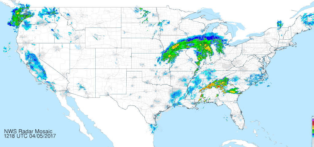
**10:10 am** Here is the National Radar Loop so you can see the moisture and the storms between here and the Gulf of Mexico.
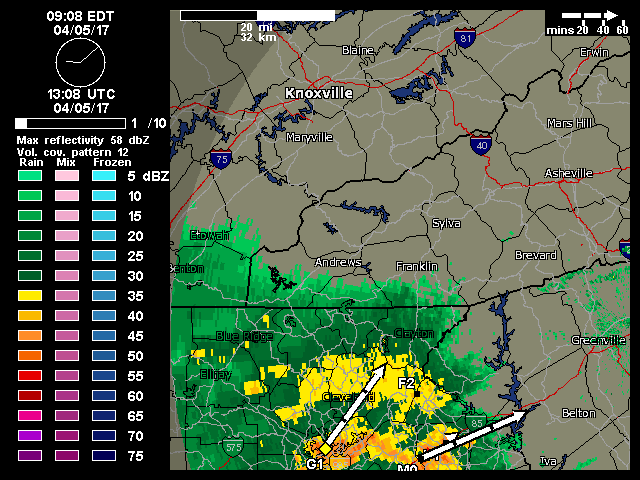
Radar loop covering 9:08 am to 9:47 am
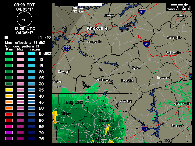
Here is a radar loop from 8:29 am to 9:12 am.
**9:03 am** A trained spotter has reported quarter inch hail in Carnesville, Georgia. This is in Franklin County.
9Future updates will only be from surrounding counties or those that are between us and storms)

SEVERE THUNDERSTORM THREAT FOR TODAY AND TONIGHT
APRIL 5 ,2017
9:00 am
There is potential for severe weather in two rounds today. The first will occur in the mid morning to early afternoon hours and the second, more dangerous situation, will occur around or after 8 pm tonight. Please be weather aware and keep a radio or other weather alerting device on nearby today and tonight.
The National Weather Service has issued a Hazardous Weather Outlook that includes Macon County. A copy is posted below:
..WEDNESDAY...Severe weather possible. A strong cold front will approach the region from the west late Wednesday. Scattered to numerous thunderstorms are expected to develop along and ahead of the front. Conditions are expected to be favorable for severe thunderstorms capable of producing damaging winds, large hail, and isolated tornadoes. Localized flash flooding will also be possible.
..THURSDAY...High winds possible. In the wake of the cold front, strong west to northwest winds will develop across the area. Winds may become strong enough from Thursday into Thursday night to cause at least isolated downed trees and power lines.
As always, you can check to see what advisories, watches and warnings are in effect for Macon County by visiting http://is.gd/MACONWARN

MESOSCALE PRECIPITATION DISCUSSION 0101...Correction
NWS WEATHER PREDICTION CENTER COLLEGE PARK MD
827 AM EDT WED APR 05 2017
AREAS AFFECTED...PORTIONS OF AL, GA, AND SC
CONCERNING...HEAVY RAINFALL...FLASH FLOODING POSSIBLE
VALID 051220Z - 051805Z
SUMMARY...BURGEONING CONVECTION IS EXPECTED TO SHOW PERIODS OF TRAINING OVER PORTIONS OF AL, GA, AND EVENTUALLY NORTHWEST/CENTRAL SC. WITH HOURLY RAIN RATES UP TO 2", AND LOCAL AMOUNTS UP TO 4", FLASH FLOODING IS POSSIBLE IN HILLY TERRAIN AND URBAN AREAS.
DISCUSSION...THUNDERSTORMS CONTINUE TO INCREASE IN COVERAGE AND INTENSITY (WITH COOLING CLOUD TOPS) UP TO 100 NM NORTHEAST OF A WARM FRONT, WITH A RECENTLY DEVELOPED LONG CONVECTIVE BAND ACROSS PORTIONS OF CENTRAL AL AS OF 12Z. INFLOW AT 850 HPA TO THE SOUTHEAST OF AN OCCLUDED CYCLONE IS BROADLY 30-40 KTS OUT OF THE SOUTHWEST PER VAD WIND PROFILES, WHICH IS IMPORTING MUCAPES OF 2000-3000 J/KG OVER THE BOUNDARY. DIVERGENCE ALOFT IS PLENTIFUL SOUTHEAST OF THE DEEP CYCLONE. PRECIPITABLE WATER VALUES, PER THE BMX SOUNDING, ARE ABOUT 1.5" (GPS PW INFORMATION LOOKS WAY TOO LOW ACROSS AL/GA).
A LONG BAND HAS ALREADY SET UP IN AL (WHICH HAS BEEN HANDLED REASONABLY WELL BY THE 06Z NAM CONEST). UNFORECAST CONVECTION HAS BEEN FORMING ACROSS PORTIONS OF GA AND RAP BASED MASS FIELDS DO NOT APPEAR TO BE MOIST ENOUGH PER THE BMX SOUNDING. BELIEVE LOCAL AMOUNTS IN THE 2-4" RANGE SHOULD BE EXPECTED, MAINLY WITHIN LONG TRAINING BANDS THOUGH SOME BACKBUILDING IS POSSIBLE AS LOW-LEVEL INFLOW RAMPS UP SLIGHTLY FURTHER, WITH BACKBUILDING MOST LIKELY NEAR THE WARM FRONT. LONG BANDS WILL GENERALLY BE NECESSARY FOR HIGHER RAIN RATES AS FORWARD PROPAGATION TO THE EAST-NORTHEAST AT 40-50 KTS IS EXPECTED. WITH INCREASING MOISTURE/INSTABILITY BEING IMPORTED AHEAD OF THE OCCLUDED CYCLONE, HOURLY RAIN RATES SHOULD LOCALLY PEAK IN THE 2" RANGE, WHICH WOULD BE PROBLEMATIC IN URBAN AND HILLY AREAS WITHIN THE REGION. THERE IS A WINDOW ROUGHLY BETWEEN 14-16Z WHERE CONVECTION SHOULD EVOLVE FROM MORE ELEVATED TO MORE SURFACE BASED AS CIN ERODES, WHICH COULD ALSO ALLOW FOR POTENTIAL BACKBUILDING. FLASH FLOODING IS MOST POSSIBLE WITHIN URBAN AREAS AND HILLY TERRAIN.
END UPDATE


0 comments :
Post a Comment