


Outlook
A cold front will cross the forecast area tonight, ushering in cold Canadian high pressure for most of the upcoming work week. Expect this high pressure to bring below normal temperatures to the region. The next front with low pressure will not approach the area until the end of the week.

News Brief
The news brief is too long to include in the daily weather briefing, so a separate article has been published.
New Aircraft Carrier Will be Named After Pearl Harbor Hero
[LINK]
Public Safety Log
Today's log is available and will be updated as needed. [LINK]
Yesterday's log is also online. [LINK]
THREE DAY GFS FORECAST
This animated image shows a forecast of precipitation, air pressure and thickness level (cold-air damming) for three days in six-hour increments.
Green, Yellow, and Red indicate rain. Orange and Purple Indicate Freezing Rain or other freezing precipitation. Blue indicates snow.

WEATHER SPONSOR

Adams Products, a Division of Oldcastle is underwriting the daily weather briefing & public safety updates for the month.
Open 7:30 AM to 4:00 PM, M-F, located at 895 Hickory Knoll Road, Franklin, NC. Visit our Facebook page at:
https://www.facebook.com/Adams.Oldcastle.Franklin.NC/
All your masonry needs are available. Our phone number is 828.524.8545, the public is welcome, we’ll help you with your next project.
Weather Hazards
A wind chill advisory has been issued effective until 10am this morning. A copy has been posted below.
Wind Chill Advisory
URGENT - WINTER WEATHER MESSAGE
National Weather Service Greenville-Spartanburg SC
1013 PM EST Sun Jan 19 2020
...WIND CHILL ADVISORY REMAINS IN EFFECT UNTIL 10 AM EST MONDAY ABOVE 3500 FEET...
* WHAT...Very cold wind chills expected. Wind chills as low as 5 below zero.
* WHERE...Portions of western North Carolina.
* WHEN...Wind chill values reaching 5 below zero through 10 AM EST Monday.
* IMPACTS...The cold wind chills could result in hypothermia if precautions are not taken.
PRECAUTIONARY/PREPAREDNESS ACTIONS...
Use caution while traveling outside. Wear appropriate clothing, a hat, and gloves.
CROWDFUNDING OR DAY SPONSORSHIP OPPORTUNITIES
If you receive value from what Macon Media provides to the community, please consider becoming a supporter and contribute at least a dollar a month. Those who support Macon Media with at least a dollar a month receive early access to video of some events and meetings before they are made public on the website. Videos and news involving public safety are not subject to early access.
Or, if you prefer Pay Pal, try PayPal.me/MaconMedia
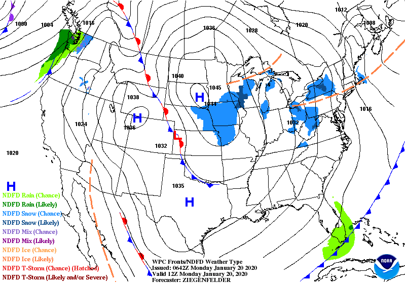
WEATHER FORECAST MAPS
Forecast maps for 7 am, 1 pm, and 7 pm.
[click on any image in this article to enlarge]


FRANKLIN AREA FORECAST
Today
Sunny, with temperatures starting off in the teens and rising to the mid-30s in the afternoon. Winds out of the northwest 5 to 10 mph.
Tonight
Partly cloudy, with lows in the mid-teens. Winds out of the northwest around 5 mph becoming calm in the evening.
Tuesday
Sunny, with highs near 40. Winds out of the northwest wind 3 to 7 mph.
Tuesday Night
Clear, with lows in the mid-to-upper teens. Light winds out of the northwest.
Wednesday
Sunny, with highs near 50.
Wednesday Night
Mostly cloudy, with lows in the mid-20s.
OTTO AREA FORECAST
Today
Sunny, with temperatures starting out in the teens and rising to the mid-30s in the afternoon. Winds out of the northwest 5 to 10 mph.
Tonight
Partly cloudy, with lows in the upper teens. Winds out of the north 3 to 5 mph.
Tuesday
Sunny, with highs near 40. WInds out of the north around 6 mph.
Tuesday Night
Clear, with lows around 20. Winds out of the northwest 3 to 5 mph.
Wednesday
Sunny, with highs near 50.
Wednesday Night
Mostly cloudy, with lows in the upper 20s.
HIGHLANDS PLATEAU FORECAST
Today
Sunny, with temperatures starting out in the teens and rising to near 30 in the afternoon. Winds out of the north 5 to 10 mph becoming light and variable by midmorning.
Tonight
Partly cloudy, with lows in the mid-teens. WInds out of the north 3 to 5 mph.
Tuesday
Sunny, with highs near freezing. Winds out of the north 5 to 10 mph.
Tuesday Night
Clear, with lows in the mid-to-upper teems. Winds out of the northeast 5 to 10 mph.
Wednesday
Sunny, with highs near 40.
Wednesday Night
Mostly cloudy, with lows in the mid-20s.
NANTAHALA AREA FORECAST
Today
Sunny, with highs in the upper 20s. Winds out of the northwest 5 to 10 mph.
Tonight
Partly cloudy, with lows in the mid-to-upper teens. Winds out of the northeast 3 to 5 mph.
Tuesday
Sunny, with highs in the mid-30s. WInds out of the north 5 to 10 mph.
Tuesday Night
Clear, with lows in the mid-to-upper teens. Winds out of the northeast around 5 mph becoming light and variable by midmorning.
Wednesday
Mostly sunny, with highs in the mid-40s.
Wednesday Night
Mostly cloudy, with lows in the mid-to-upper 20s.
Published at 5:00am on Monday, January 20, 2020


0 comments :
Post a Comment