


The National Weather Service has issued a Hazardous Weather Outlook for the WNC Mountains for excessive rainfall over the next three days that may result in flooding in certain areas in western North Carolina.
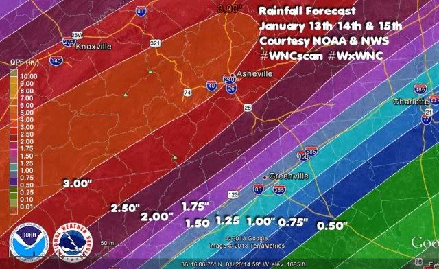
I've taken the KML File issued by the Hydrometeorological Prediction Center and produced the above graphic. The text of the outlook is below:
***Hazardous Weather Outlook***
A Cold Front will stall across western North Carolina and Northeast Georgia tonight and linger through at least Tuesday night. A deep southwesterly fetch from the western Gulf of Mexico will keep abundant moisture in place over Macon County and the rest of the region and produce heavy rainfall at times Monday through Tuesday night.
Rainfall totals of 3 to 4 inches are expected across our area. Localized flooding could start to develop around the area by Tuesday...especially in the Southwestern mountains. I heavy rainfall begins to saturate the ground tonight into early Monday...a Flood Watch could be issued for the area.
I have included the 72 hour rainfall forecast total from the Hydrometeorological Prediction Center for reference. Please take appropriate actions where necessary and stay tuned to your favorite local news source for updated forecasts from the National Weather Service.


0 comments :
Post a Comment