Western North Carolina will be receiving several inches of rain over the next few days as the remnants of Tropical Storm Lee pass over our area. Forecasts range from 3 inches to over 10 inches. Stay tuned to the National Weather Service for up to date information and your favorite local media outlet for specific road and business closures that will undoubtedly arise from this storm dumping so much rain on us in such a short period of time. You can keep an eye on conditions in western North Carolina via this Weather Dashboard provided by the GSP Office or you can watch real time GRLevel III Radar Data at a special page on Dacula Weather. I will be posting updates on this blog and via Twitter as the situation warrants and I continue to have access to the Internet. I will be out and about Tuesday afternoon and evening gathering photos and video of local flooding and the planned meeting of the Franklin Town Board of Aldermen at 7pm.
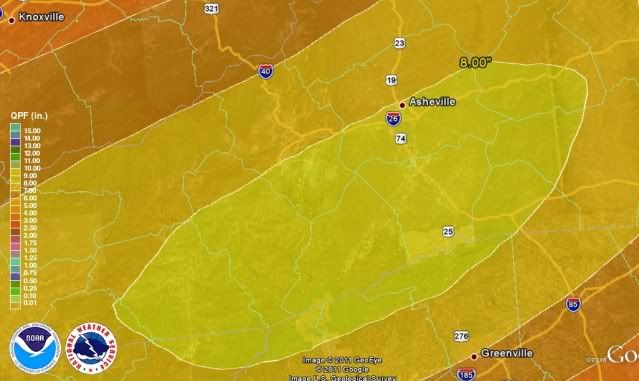
Here is a screenshot I took in Google earth of a model run displaying probable rain totals for the next 5 days this morning for western North Carolina:

As you can see, it looks like the most rain will probably fall in an area encompassing most of Macon and Jackson Counties and continuing in a northeasterly direction from there for the next 50 or so miles. This is where at least 8 inches will fall. The official NWS forecast for my location 4 miles northeast of Franklin, NC calls for 6 to 10 inches over the next 3 days. The National Weather service has already instituted a Flash Flood Watch for the entire area to alert people to the developing weather hazard that will include flooding and potential mudslides. I remind you of the mudslide that killed 4 people in the Peeks creek Community after the remnants of Hurricanes Frances and Ivan passed over our area.
Latest Area Forecast Discussion from the National Weather Service GSP Office:
(click on highlighted words for NWS Glossary definition)
000
FXUS62 KGSP 041858
AFDGSP

AREA FORECAST DISCUSSION
NATIONAL WEATHER SERVICE GREENVILLE-SPARTANBURG SC
258 PM EDT SUN SEP 4 2011

.SYNOPSIS...
A COLD FRONT WILL APPROACH THE CAROLINAS TONITE AND STALL OVER THE
AREA EARLY THIS WEEK. MEANWHILE...TROPICAL STORM LEE WILL PUSH
NORTHEAST TOWARD THE AREA...WITH THE REMNANTS OF LEE THEN MOVING
NORTH TO CENTRAL TENNESSEE...AND INTO CENTRAL KENTUCKY BY MID WEEK.

&&

.NEAR TERM /THROUGH MONDAY/...
SCATTERED CONVECTION WILL CONTINUE TO FIRE ACROSS THE HIGHER TERRAIN
THIS AFTERNOON...WITH A GRADUAL INCREASE IN COVERAGE EXPECTED AS
APPROACHING COLD FRONT TAPS INTO MOISTURE ASSOCIATED WITH TROPICAL
STORM LEE. THE THREAT FOR SEVERE WEATHER THIS AFTERNOON IS LOW.
HOWEVER...THERE ARE MODERATE LEVELS OF DOWNDRAFT CAPE ACROSS
PORTIONS OF THE MTNS...SO AN ISOLATED MICROBURST IS NOT OUT OF THE
QUESTION. ACROSS THE REMAINDER OF THE AREA...CONVECTION THIS
AFTERNOON SHOULD REMAIN ISOLATED. BY ABOUT MID-EVENING...RAIN
CHANCES WILL INCREASE ACROSS THE UPPER SAVANNAH RIVER VALLEY...AS
RAIN BANDS CIRCULATING AROUND LEE BEGIN TO ENCROACH ON THE AREA.

AS THE FRONT FINALLY PUSHES INTO THE REGION LATER TONIGHT...FORCING
WILL BEGIN TO INCREASE AS WILL THE HEAVY RAIN THREAT. IN FACT...THE
GFS DEPICTS A FAIRLY INTENSE REGION OF LOW-LEVEL FRONTOGENESIS
WITHIN LOW LEVEL CONVERGENCE AXIS. THIS DEGREE OF FORCING ACTING ON
A TROPICAL AIR MASS WILL LIKELY BEGIN TO RESULT IN HEAVY RAIN ACROSS
THE MTNS PRIOR TO 12Z. INCREASING SOUTHERLY FLOW WILL ENHANCE
AMOUNTS ACROSS THE SW NC MTNS/WESTERN UPSTATE MTNS/NORTHEAST GA MTNS
LATE TONIGHT/EARLY MONDAY THROUGH THE DAY MONDAY. UNFORTUNATELY...
THE FRONTOGENESIS BAND IS PROGGED TO MOVE ONLY VERY SLOWLY DURING
THE DAY MONDAY. AND RAINFALL AMOUNTS OF 3 TO 6 INCHES WILL BE LIKELY
ACROSS THESE AREAS BY 00Z TUESDAY.

AHEAD OF THE MAIN FRONTOGENETICAL BAND...NUMEROUS TO WIDESPREAD
SHOWERS ARE EXPECTED ACROSS THE PIEDMONT AND FOOTHILLS...AND UP TO 2
INCHES WILL BE POSSIBLE IN THESE AREAS BY THE END OF THE DAY MONDAY.
IN ADDITION...SOME INSTABILITY (ALBEIT WEAK) WILL LIKELY BE REALIZED
IN THE PIEDMONT. A MODERATELY STRONG SOUTHERLY LOW LEVEL JET WILL
RESULT IN VERY LONG...STRONGLY TURNING HODOGRAPHS. ISOLATED MINI-
SUPERCELLS AND BRIEF ISOLATED TORNADOES WILL BE POSSIBLE TOMORROW
AFTERNOON.

&&

.SHORT TERM /MONDAY NIGHT THROUGH WEDNESDAY/...
AS OF 240 PM SUNDAY...THE UPPER TROF SWEEPS ACROSS THE OH VALLEY MON
NIGHT AND TOWARD NEW ENGLAND TUE...WHILE THE UPPER LOW ASSOC WITH
THE REMNANTS OF TS LEE MOVES FROM THE LOWER MS VALLEY TUE...N TOWARD
THE OH VALLEY WED. THE OFFICIAL TRACK OF THE SFC CIRCULATION ASSOC
WITH TS LEE WILL MOVE FROM S MS/AL MON NIGHT TO CNTRL AL TUE TO
CNTRL TN WED. WITH DEEP TROPICAL MOISTURE...ISENTROPIC LIFT AND GOOD
UPSLOPE FLOW OVER THE CWA MON NIGHT THRU TUE INTO TUE NIGHT...
PERIODS OF HEAVY RAIN WILL CONTINUE WITH A SIGNIFICANT FLOODING
THREAT. A FLASH FLOOD WATCH HAS BEEN ISSUED FOR THE MTNS...FOOTHILLS
AND ADJACENT PIEDMONT. CAPE VALUES OVER 1000 J/KG ARE FCST TUE AFTN
AND WITH BULK SHEAR OF 20-30KT...SVR STORMS WILL BE PSBL WITH AN
ISOLD TORNADO OR TWO PSBL. LOWS WILL BE ABOVE AVG TUE MRNG WITH AFTN
HIGHS BELOW AVG. TEMPS ARE EXPECTED TO BE BELOW AVG WED.

&&


0 comments :
Post a Comment