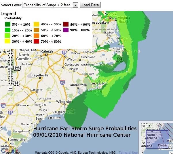
The above graphic indicates areas on the North Carolina coast where the probability exists that the storm surge will exceed 2 feet from Hurricane Earl. As you can see, the probability is low at this point.
Let me begin by noting that most of the coverage I've seen via the Weather Channel and other news outlets is overly sensational. Odds are, and the current model runs support me on this, is that Hurricane Earl will only brush the Outer Banks of North Carolina with 50 to 60% chance that they could even see tropical storm force winds. The biggest problem will be with rainfall that may lead to flooding in low-lying areas and wave action that will continue the process of eroding away the Outer Banks of North Carolina.
You can keep up with this storm for yourself at the National Hurricane Center, and see the latest model runs at the website of the South Florida Water Management District. I've posted the latest run below.
Another good source I've come to rely upon is Mark Suddoth's Hurricane Track. He is my goto guy for Hurricanes and live coverage of tropical weather. He is based out of Wilmington, NC. He is currently (as I write this) on the way to the coast to stream live video from the coast...he will be stopping in New Bern for breakfast this morning.
Here is his Ustream Feed:
Here is the latest advisory from the National Hurricane Center as of 5 am this morning:
000
WTNT32 KNHC 010840
TCPAT2
BULLETIN
HURRICANE EARL ADVISORY NUMBER 28
NWS TPC/NATIONAL HURRICANE CENTER MIAMI FL AL072010
500 AM EDT WED SEP 01 2010
...EARL NOW A CATEGORY THREE HURRICANE...HURRICANE WATCH EXTENDED
NORTHWARD ALONG THE VIRGINIA COAST...
SUMMARY OF 500 AM EDT...0900 UTC...INFORMATION
----------------------------------------------
LOCATION...24.0N 71.2W
ABOUT 175 MI...280 KM N OF GRAND TURK ISLAND
ABOUT 815 MI...1315 KM SSE OF CAPE HATTERAS NORTH CAROLINA
MAXIMUM SUSTAINED WINDS...125 MPH...205 KM/HR
PRESENT MOVEMENT...NW OR 310 DEGREES AT 16 MPH...26 KM/HR
MINIMUM CENTRAL PRESSURE...941 MB...27.79 INCHES
WATCHES AND WARNINGS
--------------------
CHANGES WITH THIS ADVISORY...
A HURRICANE WATCH HAS BEEN ISSUED FOR THE COAST OF VIRGINIA FROM THE
NORTH CAROLINA/VIRGINIA BORDER TO PARRAMORE ISLAND.
THE GOVERNMENT OF THE BAHAMAS HAS ISSUED A TROPICAL STORM WARNING
FOR SAN SALVADOR ISLAND IN THE CENTRAL BAHAMAS.
THE GOVERNMENT OF THE BAHAMAS HAS DISCONTINUED ALL WARNINGS AND
WATCHES FOR THE SOUTHEASTERN BAHAMAS AND THE TURKS AND CAICOS
ISLANDS.
SUMMARY OF WATCHES AND WARNINGS IN EFFECT...
A HURRICANE WATCH IS IN EFFECT FOR...
* NORTH OF SURF CITY NORTH CAROLINA TO PARRAMORE ISLAND
VIRGINIA...INCLUDING THE PAMLICO AND ALBEMARLE SOUNDS
A TROPICAL STORM WARNING IS IN EFFECT FOR...
* SAN SALVADOR ISLAND IN THE CENTRAL BAHAMAS
A TROPICAL STORM WATCH IS IN EFFECT FOR...
* THE NORTH CAROLINA COAST FROM CAPE FEAR TO SURF CITY
A HURRICANE WATCH MEANS THAT HURRICANE CONDITIONS ARE POSSIBLE
WITHIN THE WATCH AREA. A WATCH IS TYPICALLY ISSUED 48 HOURS
BEFORE THE ANTICIPATED FIRST OCCURRENCE OF TROPICAL-STORM-FORCE
WINDS...CONDITIONS THAT MAKE OUTSIDE PREPARATIONS DIFFICULT OR
DANGEROUS.
A TROPICAL STORM WARNING MEANS THAT TROPICAL STORM CONDITIONS ARE
EXPECTED SOMEWHERE WITHIN THE WARNING AREA WITHIN 36 HOURS.
INTERESTS ELSEWHERE FROM VIRGINIA NORTHWARD TO NEW ENGLAND SHOULD
MONITOR THE PROGRESS OF EARL.
FOR STORM INFORMATION SPECIFIC TO YOUR AREA IN THE UNITED
STATES...INCLUDING POSSIBLE INLAND WATCHES AND WARNINGS...PLEASE
MONITOR PRODUCTS ISSUED BY YOUR LOCAL NATIONAL WEATHER SERVICE
FORECAST OFFICE. FOR STORM INFORMATION SPECIFIC TO YOUR AREA OUTSIDE
THE UNITED STATES...PLEASE MONITOR PRODUCTS ISSUED BY YOUR NATIONAL
METEOROLOGICAL SERVICE.


0 comments :
Post a Comment