


This is one powerful storm. It has been several hours after the eye of the storm has come ashore...and Hurricane Ike still has maximum sustained winds of 110 MPH, making it a strong Category 2 Storm on the Saffir-Simpson Scale.
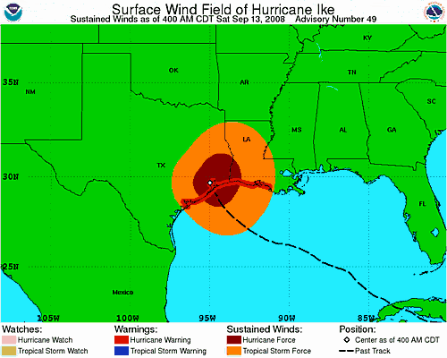
To give you an idea...look at this graphic that shows the areas affected by tropical storm force winds (orange), and those affected by hurricane force winds (wine) as of 5 AM Eastern Time:
Here is the latest advisory issued by the National Weather Service in Houston/Galveston:
000
WTUS84 KHGX 131020
HLSHGX
URGENT - IMMEDIATE BROADCAST REQUESTED
HURRICANE IKE LOCAL STATEMENT
NATIONAL WEATHER SERVICE HOUSTON/GALVESTON TX
520 AM CDT SAT SEP 13 2008
...HURRICANE IKE TRACKS OVER GALVESTON BAY...
AT 400 AM CDT THE CENTER OF HURRICANE IKE WAS LOCATED NEAR LATITUDE
29.7 NORTH LONGITUDE 95.0 WEST OR NEAR BAYTOWN TEXAS. THIS POSITION
IS ABOUT 30 MILES NORTH- NORTHWEST OF GALVESTON TEXAS AND ABOUT 25
MILES EAST OF HOUSTON TEXAS.
IKE IS MOVING TOWARD THE NORTHWEST NEAR 13 MPH. A TURN TOWARD THE
NORTH IS EXPECTED LATER TODAY WITH A TURN TOWARD THE NORTHEAST AND
AN INCREASE IN FORWARD SPEED EXPECTED TONIGHT AND SUNDAY. ON THE
FORECAST TRACK THE CENTER OF IKE WILL MOVE THROUGH SOUTHEASTERN AND
EASTERN TEXAS TODAY AND INTO WESTERN ARKANSAS TONIGHT.
MAXIMUM SUSTAINED WINDS ARE NEAR 110 MPH WITH HIGHER GUSTS. IKE IS A
CATEGORY TWO HURRICANE ON THE SAFFIR- SIMPSON SCALE. WEAKENING IS
EXPECTED AS THE CENTER MOVES FARTHER INLAND ALTHOUGH IKE IS EXPECTED
TO REMAIN A HURRICANE THROUGH THIS AFTERNOON.
HURRICANE FORCE WINDS EXTEND OUTWARD UP TO 125 MILES FROM THE CENTER
AND TROPICAL STORM FORCE WINDS EXTEND OUTWARD UP TO 260 MILES.
HURRICANE-FORCE WINDS ARE LIKELY TO OCCUR WELL INLAND NEAR AND TO
THE EAST OF THE CENTER. PORT ARTHUR TEXAS RECENTLY REPORTED A WIND
GUST OF 96 MPH.
THE ESTIMATED MINIMUM CENTRAL PRESSURE IS 954 MB...28.17 INCHES.
THE NATIONAL OCEAN SERVICE STATION AT THE GALVESTON PLEASURE PIER
REPORTED A MINIMUM PRESSURE OF 951.6 MB...28.10 INCHES...AS THE
EYE OF IKE PASSED OVER THE STATION.


0 comments :
Post a Comment