Tornado Watch for WNC Mountains

Posted by Thunder Pig Wednesday, May 6, 2009


Graphic: NWS Watches and Warnings.

Keep your heads up, and an ear to NOAA Radio and your eyes on the skies!


This is the Asheville NOAA livestream. Press the play button to turn on the player.
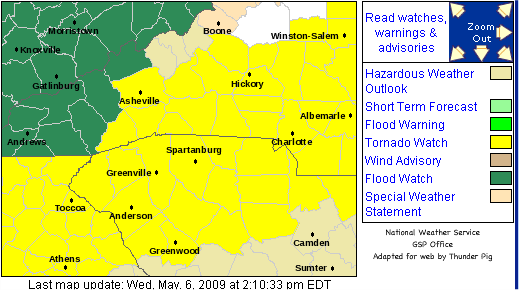

Tornado Watch

TORNADO WATCH OUTLINE UPDATE FOR WT 256
NWS STORM PREDICTION CENTER NORMAN OK
215 PM EDT WED MAY 6 2009

TORNADO WATCH 256 IS IN EFFECT UNTIL 900 PM EDT FOR THE
FOLLOWING LOCATIONS

NCC001-003-007-015-021-023-025-027-029-033-035-037-041-045-053-
057-059-063-065-067-069-071-073-077-081-083-085-089-091-097-101-
105-109-111-119-123-125-127-131-135-139-143-145-149-151-153-157-
159-161-167-169-175-179-181-183-185-195-197-070100-
/O.NEW.KWNS.TO.A.0256.090506T1815Z-090507T0100Z/

NC
. NORTH CAROLINA COUNTIES INCLUDED ARE

ALAMANCE             ALEXANDER           ANSON
BERTIE BUNCOMBE BURKE
CABARRUS CALDWELL CAMDEN
CASWELL CATAWBA CHATHAM
CHOWAN CLEVELAND CURRITUCK
DAVIDSON DAVIE DURHAM
EDGECOMBE FORSYTH FRANKLIN
GASTON GATES GRANVILLE
GUILFORD HALIFAX HARNETT
HENDERSON HERTFORD IREDELL
JOHNSTON LEE LINCOLN
MCDOWELL MECKLENBURG MONTGOMERY
MOORE NASH NORTHAMPTON
ORANGE PASQUOTANK PERQUIMANS
PERSON POLK RANDOLPH
RICHMOND ROCKINGHAM ROWAN
RUTHERFORD STANLY STOKES
TRANSYLVANIA UNION VANCE
WAKE WARREN WILSON
YADKIN

0 comments

Related Posts Plugin for WordPress, Blogger...

Copyright Notice

Copyright © 2005-2012 Bobby Coggins

Badges and Buttons


Register now for RightOnline 2012 [link], using the promotional discount code “fightbackonline” to receive $10 off registration

I look forward to seeing you there!


Personal Account

Public Policy Account

Radio Monitoring Account

Ads


Contact Info


To submit releases for publication, email me here. This includes Guest Commentaries. If you have a photo that you wish me to use with your press release or article, please send it to me, otherwise I'll use whatever I feel best fits your article.

For a quicker response, send me a message on Twitter or add me to a circle on Google Plus and send it just to me.

If you have been sending me press releases via my private email address, that will continue to work just fine. The Twitter or Google+ account will get my attention quicker.

Google Plus Feed

-Live Breaking News-


WATCH NASA TV


NHC Tropical Weather Outlook

Ads

Thousands of Deadly Islamic Terror Attacks Since 9/11


Twitter Widgets

TwitPics

TIP JAR


Donations accepted for the purpose of supporting this blog and activities related to improving it's operations and my coverage of local festivals and local government meetings.
Bloggers' Rights at EFF

John Batchelor Show Podcasts