


**7.12am** ![]() I'm cranking the Snow Siren. Make sure that you have adequate supplies and a reliable source of heat. I'm feeling more confident that we could be witnessing an historic snow event in the Carolinas...certainly in the central region, maybe in the mountains as well. Please check the weather forecast every so often over the next few days via your favorite broadcaster or the National Weather Service.
I'm cranking the Snow Siren. Make sure that you have adequate supplies and a reliable source of heat. I'm feeling more confident that we could be witnessing an historic snow event in the Carolinas...certainly in the central region, maybe in the mountains as well. Please check the weather forecast every so often over the next few days via your favorite broadcaster or the National Weather Service.
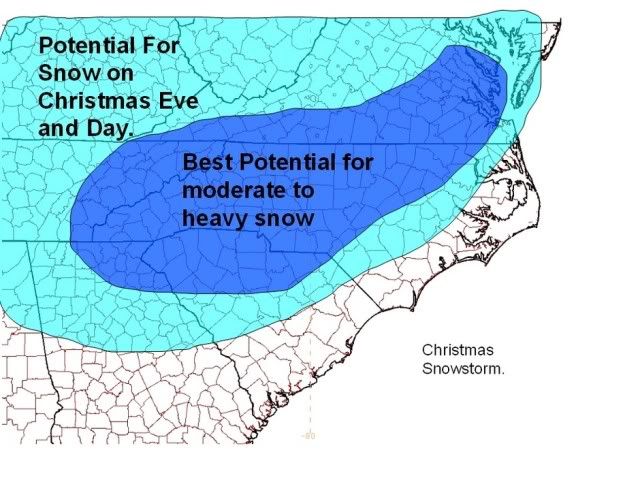
The above graphic comes from an article in the crowd-sourced Examiner website. The author gives a range of 1-3 inches on the low side and 10-20 inches on the high side for western North Carolina. Read his article for more information. He also has his own web page.
**3.42am** The following is a highly technical (weather geeks only) discussion of the storm:
Here is a Blog Talk Radio Show that discusses weather and mentions this storm...

Listen to internet radio with AmericanWx on Blog Talk Radio
The National Weather Service is hedging their bet, too...although they do not mention the possibility of a superstorm like the Examiner author does. Here is the latest statement from the GSP Office:
LOW PRESSURE IS EXPECTED TO MOVE ACROSS THE DEEP SOUTH CHRISTMAS
DAY. AT THIS TIME THERE IS STILL UNCERTAINTY AS TO HOW STRONG THE
LOW WILL BE AND HOW FAR SOUTH IT WILL TRACK...AS WELL AS THE TIMING
OF PRECIPITATION. HOWEVER...THERE IS A GOOD CHANCE OF WINTRY
PRECIPITATION FALLING FRIDAY NIGHT INTO SATURDAY NIGHT ACROSS THE
NORTH CAROLINA MOUNTAINS. IF THE LOW TRACKS WELL SOUTH OF THE
REGION...MAINLY SNOW WILL FALL. IF THE LOW STAYS FARTHER NORTH...
CROSSING THE CAROLINAS...THEN MORE OF A MIX OF WINTRY PRECIPITATION
TYPES WILL OCCUR. AS THE LOW DEEPENS ALONG THE SOUTHEAST COAST ON
SUNDAY...SNOWFALL...ALONG WITH WINDY CONDITIONS AND LOW WIND
CHILLS...WILL CONTINUE OVER THE NORTH CAROLINA MOUNTAINS...MAINLY
NEAR THE TENNESSEE BORDER. RESIDENTS AND THOSE WITH TRAVEL PLANS
ACROSS WESTERN NORTH CAROLINA THIS WEEKEND SHOULD CLOSELY MONITOR
THE FORECAST FOR THIS POTENTIAL WINTER STORM EVENT.
The forecast for the extreme western part of Macon County is a different animal altogether. The Morristown Office of the National Weather Service provides forecasts for that area...and it is as follows:
...ACCUMULATING SNOW POSSIBLE THIS WEEKEND...
A LOW PRESSURE SYSTEM IS FORECAST TO DEVELOP NEAR THE GULF COAST
FRIDAY BEFORE TRACKING ACROSS THE SOUTHEASTERN STATES AND THEN
NORTHEAST OFF THE CAROLINA COAST. WHILE THE TRACK OF THIS STORM
IS STILL VERY UNCERTAIN...THIS SYSTEM HAS THE POTENTIAL TO BRING
SIGNIFICANT SNOW ACCUMULATIONS TO THE REGION CHRISTMAS EVE INTO
CHRISTMAS DAY.
PRECIPITATION IS EXPECTED TO MOVE INTO THE AREA FRIDAY AFTERNOON OR
FRIDAY NIGHT. THE PRECIPITATION MAY BEGIN AS RAIN...ESPECIALLY OVER
SOUTHERN AREAS...BUT IS FORECAST TO TRANSITION TO ALL SNOW BY EARLY
SATURDAY MORNING. THE SNOW IS FORECAST TO DIMINISH SATURDAY...BEFORE
TRANSITIONING TO SNOW SHOWERS AND FLURRIES FOR SATURDAY NIGHT AND
SUNDAY.
THE DETAILS OF THIS SYSTEM ARE STILL VERY UNCERTAIN...AND THERE IS
STILL THE POTENTIAL THAT MUCH OF THE PRECIPITATION WILL FALL AS
RAIN OR THAT THE SYSTEM WILL TRACK FAR ENOUGH AWAY THAT VERY LITTLE
PRECIPITATION WILL FALL IN OUR AREA. HOWEVER...AT THIS TIME IT
APPEARS LIKELY THAT AT LEAST SOME SNOW WILL FALL...AND SIGNIFICANT
ACCUMULATIONS ARE POSSIBLE. RIGHT NOW THE BEST CHANCES FOR
SIGNIFICANT SNOW ACCUMULATIONS APPEAR TO BE ACROSS SOUTHWEST
VIRGINIA...THE NORTHERN HALF OF EAST TENNESSEE...AND THE HIGHER
ELEVATIONS...WHERE THE PROBABILITY OF AN EXTENDED PERIOD OF RAIN IS
LOWER.
STAY TUNED TO NOAA WEATHER RADIO AND OTHER LOCAL MEDIA FOR FURTHER
DETAILS OR UPDATES ON THIS POTENTIAL WINTER WEATHER SITUATION.
Anyway, enough speculation for the future...here is a handy-dandy table from the National Weather Service giving the record of previous White Christmases in western North Carolina and Upstate South Carolina during their period of record-keeping...
| Snowfall on Christmas Day (1878-2009) | ||||
| Click on a year for a map | ||||
| Will We Have a White Christmas? | ||||
| Year | AVL Downtown | AVL Airport | CLT | GSP |
| 1880 | 4.0 | |||
| 1889 | T | |||
| 1902 | T | |||
| 1909 | 0.1 | |||
| 1914 | T | |||
| 1915 | 0.3 | |||
| 1919 | T | |||
| 1924 | T | |||
| 1929 | T | |||
| 1935 | 0.1 | |||
| 1943 | T | |||
| 1945 | 0.4 | |||
| 1947 | 3.4 | 5.8 | 2.0 | |
| 1948 | T | |||
| 1953 | T | T | ||
| 1956 | T | |||
| 1961 | T | |||
| 1962 | 0.3 | T | ||
| 1963 | 1.4 | |||
| 1965 | T | T | ||
| 1966 | T | 0.0 | T | |
| 1969 | 9.4 | 5.4 | T | T |
| 1970 | 0.4 | |||
| 1975 | T | 0.4 | T | T |
| 1977 | T | |||
| 1976 | T | |||
| 1979 | T | T | ||
| 1980 | 0.2 | T | ||
| 1981 | 3.0 | 2.0 | ||
| 1983 | T | |||
| 1985 | 0.3 | T | ||
| 1989 | 0.2 | |||
| 1993 | 0.7 | 0.4 | T | Note 1 |
| 1995 | 0.1 | T | ||
| 1998 | T | T | T | Note 2 |
| 1999 | T | T | ||
| 2002 | T | T | ||
| 2007 | T | T | T | |
| ��� Note 1: Scattered snowshowers in the Upstate�no GSP accumulation. | ||||
| ��� Note 2: A few areas of snowshowers near the NC border�no GSP accumulation. | ||||
The GSP Office of the National Weather Service sounds like they're getting on board with some snow this Christmas...
HAZARDOUS WEATHER OUTLOOK
NATIONAL WEATHER SERVICE GREENVILLE-SPARTANBURG SC
459 AM EST WED DEC 22 2010
THIS HAZARDOUS WEATHER OUTLOOK IS FOR WESTERN NORTH CAROLINA.
.DAY ONE...TODAY AND TONIGHT.
A LIGHT ACCUMULATION OF SNOW IS POSSIBLE ALONG THE TENNESSEE
BORDER TONIGHT.
.DAYS TWO THROUGH SEVEN...THURSDAY THROUGH TUESDAY.
LOW PRESSURE IS EXPECTED TO MOVE ACROSS THE DEEP SOUTH THIS
WEEKEND. CONFIDENCE IS SLOWLY AND GRADUALLY IMPROVING THAT THE LOW
PRESSURE SYSTEM WILL MOVE TO THE SOUTH OF THE REGION CHRISTMAS DAY
AND SATURDAY NIGHT...WITH PRECIPITATION FALLING WHILE COLD AIR IS
IN PLACE ACROSS MOST OF THE REGION. AT THIS TIME...CONSIDERABLE
UNCERTAINTY REMAINS AS TO THE TIMING AND AMOUNT OF PRECIPITATION.
IF MODEL GUIDANCE IS CORRECT...ACCUMULATING SNOW IS LIKELY TO THE
NORTH OF A LINE FROM HARTWELL TO ANDERSON AND LAURENS...STARTING
ON CHRISTMAS MORNING AND CONTINUING INTO SATURDAY EVENING.
DEPENDING ON HOW MUCH MOISTURE IS AVAILABLE TO THE LOW AS IT MOVES
PAST... AMOUNTS COULD RANGE ANYWHERE FROM ONE TO SEVERAL INCHES OF
SNOW. LATER DEVELOPMENTS WILL DETERMINE IF...WHEN...AND WHERE A
WINTER STORM WATCH WILL BE ISSUED. AS THE LOW RAPIDLY DEEPENS
ALONG THE SOUTHEAST COAST ON SUNDAY... SNOWFALL...ALONG WITH WINDY
CONDITIONS AND LOW WIND CHILLS...WILL CONTINUE OVER THE NORTH
CAROLINA MOUNTAINS. RESIDENTS AND PEOPLE WITH TRAVEL PLANS ACROSS
THE WESTERN CAROLINAS THIS WEEKEND SHOULD CONTINUE TO MONITOR THE
FORECAST FOR THIS POTENTIAL WINTER STORM EVENT.
.SPOTTER INFORMATION STATEMENT...
NONE.
$$


4 comments :
Dude, do you ever sleep?
I will be making a special trip to the store to stock up on supplies.
The girls will be excited. They have never seen a white Christmas before.
Thank you for the advance warning on this storm. Groceries are a good idea, Brendan. I will be getting some bread and milk before the word gets out. lol
Tsk tsk. After all the complaining about others who crank the snow sirens. I'm never going to let you forget this if you're wrong.
JR in Franklin
Thx Thunderpig! Shared and advisory appreciated! My daughter was going to drive in from Greensboro ;(
We will have to postpone that trip!
Stay warm my friend!
Merry Christmas* TuesdayisGone
Post a Comment