


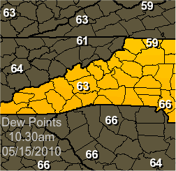
**10.54am** I added a Dew Point Graphic to the bottom of the post. Today could be epic for WNC!
Parts of Western North Carolina will likely be seeing thunderstorms today, and some of them will get severe, so keep a lookout on the skies this afternoon and evening. I'll be looking for opportunities to get some time lapses of the storms as they build up.
Data from the Storm Prediction Center in Norman, OK:
  ...TN VLY TO SRN APPALACHIANS...
   TSTMS NOW OVER LA/AR...ASSOCIATED WITH LEAD UPR IMPULSE AND EMBEDDED
   MCVS...SHOULD CONTINUE GENERALLY NE TOWARD THE LWR TN AND OH VLYS
   LATER TODAY.  AHEAD OF THIS ACTIVITY...ADDITIONAL STORMS MAY FORM BY
   AFTN OVER WRN TN AND WRN/NRN MS AS SFC HEATING OF WEAKLY CAPPED
   ENVIRONMENT BOOSTS SBCAPE TO AROUND 2000 J/KG.  FARTHER E...ANOTHER
   AREA OF DEVELOPMENT MAY FOCUS OVER ERN TN/WRN NC...WHERE UPSLOPE
   FLOW WILL EXIST BENEATH JET ENTRANCE REGION ALOFT.  35 KT SW TO
   WSWLY MID LVL FLOW SHOULD SUPPORT LOOSELY-ORGANIZED BANDS/CLUSTERS
   OF STORMS...INCLUDING SUSTAINED MULTICELLS AND PERHAPS A FEW
   SHORT-LIVED SUPERCELLS.  THESE COULD YIELD DMGG WIND AND HAIL.  THE
   SVR THREAT SHOULD DIMINISH WITH SUNSET.
**10.54am** Here is a Dew Point Graphic. I've also noticed that many of the Composite Indices for Severe Weather are spiking for our area. Take a gander at the Mesoscale Analysis Page and you'll see what I mean. Today could be epic for WNC!


0 comments :
Post a Comment