


The snow sirens are sounding loudly throughout West Carolina over a few inches of snow. I suppose it is for the best because most people who live in the mountains are no longer native to the region, and can't handle driving on snow or in slipperly conditions provided by a dusting of snow that is forecast by this event.
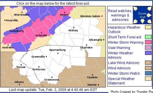
The GSP Office of the National Weather Service has released the following statement for the areas shaded in pink in the above map:
NCZ033-048>052-058-059-031700-
/O.CON.KGSP.WS.W.0003.090203T1700Z-090205T0500Z/
AVERY-MADISON-YANCEY-MITCHELL-SWAIN-HAYWOOD-GRAHAM-
NORTHERN JACKSON-
INCLUDING THE CITIES OF...NEWLAND...SPRUCE PINE...CHEROKEE...
WAYNESVILLE...SYLVA
331 AM EST TUE FEB 3 2009
...WINTER STORM WARNING REMAINS IN EFFECT FROM NOON TODAY TO MIDNIGHT EST WEDNESDAY NIGHT...
A WINTER STORM WARNING REMAINS IN EFFECT FROM NOON TODAY TO MIDNIGHT EST WEDNESDAY NIGHT.
SNOW SHOWERS WILL BECOME WIDESPREAD THIS AFTERNOON ACROSS THE TENNESSEE BORDER COUNTIES...AS WELL AS NORTHERN JACKSON COUNTY.
BURSTS OF HEAVY SNOW MAY OCCUR THROUGH THE EVENING HOURS AND AGAIN ON WEDNESDAY. BY THE TIME THE SHOW SHOWERS TAPER OFF TO FLURRIES LATE WEDNESDAY NIGHT...AN ACCUMULATION OF 4 TO 8 INCHES OF SNOW IS EXPECTED. SOME HIGHER ELEVATIONS ALONG THE TENNESSEE BORDER MAY RECEIVE AS MUCH AS 10 TO 12 INCHES OF SNOW.
WIND GUSTS OF 20 TO 30 MPH MAY CAUSE CONSIDERABLE BLOWING AND DRIFTING OF THE SNOW...AND MAY REDUCE THE VISIBILITY AT TIMES.
WIND CHILL VALUES WILL FALL TO 10 TO 15 DEGREES BELOW ZERO AT HIGHER ELEVATIONS TONIGHT AND WEDNESDAY MORNING.
A WINTER STORM WARNING FOR HEAVY SNOW MEANS SEVERE WINTER WEATHER CONDITIONS ARE EXPECTED OR OCCURRING. SIGNIFICANT AMOUNTS OF SNOW ARE FORECAST THAT WILL MAKE TRAVEL DANGEROUS.
So, if you are out and about, keep some extra distance between you and the other drivers, and allow for some extra travel time...and always check with the National Weather Service for official storm information. I still have some hope that we might get a real snow before the end of the season.
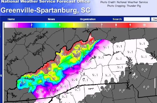
Check out the forecast totals through Wednesday morning:
WIND GUSTS OF 20 TO 30 MPH MAY CAUSE CONSIDERABLE BLOWING AND DRIFTING OF THE SNOW...AND MAY REDUCE THE VISIBILITY AT TIMES.
WIND CHILL VALUES WILL FALL TO 10 TO 15 DEGREES BELOW ZERO AT HIGHER ELEVATIONS TONIGHT AND WEDNESDAY MORNING.
A WINTER STORM WARNING FOR HEAVY SNOW MEANS SEVERE WINTER WEATHER CONDITIONS ARE EXPECTED OR OCCURRING. SIGNIFICANT AMOUNTS OF SNOW ARE FORECAST THAT WILL MAKE TRAVEL DANGEROUS.
So, if you are out and about, keep some extra distance between you and the other drivers, and allow for some extra travel time...and always check with the National Weather Service for official storm information. I still have some hope that we might get a real snow before the end of the season.
Check out the forecast totals through Wednesday morning:


0 comments :
Post a Comment