Notice

I am working on the template of this blog today in order to chase down some problems that have developed with my template and widgets.

Macon County Commissioners

Coverage of the meetings of the Macon County Board of County Commissioners.

Franklin Town Board of Aldermen

Coverage of the meetings of the Franklin Town Board of Aldermen.

Macon County School Board

Coverage of the meetings of the Macon County School Board.

Photoblog

Photos from my photoblog.

nullspace for future use

nullspace for future use

About

Showing posts with label April 2019 Weather. Show all posts

Friday, April 23, 2021

Weather Briefing for Friday, April 23, 2021
SpaceX Crew 2 Launch


OUTLOOK

Broad Canadian high pressure will center over the Lower MS Valley and Deep South today and shift over the Carolinas and eventually offshore on Friday. Much below normal temperatures develop across the region today and tonight, while remaining over the area through Friday. A more significant low pressure system will cross our region Saturday and Saturday night. High pressure returns for the early part of next week with warmer temperatures expected through the middle part of the week.


---BEGIN SPONSOR SEGMENT---


Weather Sponsor


Adams Products, a Division of Oldcastle is underwriting the daily weather briefing & public safety updates for the month.

Open 7:30 AM to 4:00 PM, M-F, located at 895 Hickory Knoll Road, Franklin, NC. Visit our Facebook page at: https://www.facebook.com/Adams.Oldcastle.Franklin.NC

All your masonry needs are available. Our phone number is 828.524.8545, the public is welcome, we’ll help you with your next project.


The President Orders Flags at Half Staff for Former Vice President Walter Mondale -- April 19, 2021 through Day of Interment [LINK]

National Weather Map for Today


General forecast through Sunday Night


Franklin area

Today
INCREASED FIRE DANGER TODAY
Areas of frost before 9am. Otherwise, partly sunny, with highs in the mid-60s. Calm winds in the morning increasing to come out of the southwest around 5 mph in the afternoon.

Tonight

Showers likely, mainly after 5am. Mostly cloudy, with lows in the mid-40s. Winds out of the south around 5 mph becoming calm before midnight. Chance of precipitation is 60%. New precipitation amounts of less than a tenth of an inch possible.

Saturday

Showers, with thunderstorms also possible after 2pm. Highs in the lower 60s. Light winds out of the southeast early increasinbg to come out of the southeast 5 to 10 mph iby midmorning. Winds could gust as high as 25 mph. Chance of precipitation is 100%. New rainfall amounts between three quarters and one inch possible.

Saturday Night

A chance of showers and thunderstorms before 2am, then a slight chance of showers. Mostly cloudy, with lows in the mid-to-upper 40s. Winds out of the southwest around 5 mph becoming calm before midnight. Chance of precipitation is 50%.

Sunday

Mostly sunny, with highs near 70.

Sunday Night

Mostly clear, with lows around 40.

Highlands area

Today
INCREASED FIRE DANGER TODAY
Partly sunny, with highs in the mid-50s. Calm winds in the morning increasing to come out of the southwest around 5 mph in the afternoon.

Tonight

Showers likely, mainly after 5am. Increasing clouds, with lows around 40. Winds out of the southwest around 5 mph becoming calm. Chance of precipitation is 60%. New precipitation amounts between a tenth and quarter of an inch possible.

Saturday

Showers, with thunderstorms also possible after 2pm. Some of the storms could produce heavy rainfall. Patchy fog before 9am. Highs in the lower 50s. Winds out of the southeast 5 to 10 mph, with gusts as high as 25 mph. Chance of precipitation is 100%. New rainfall amounts between 1 and 2 inches possible.

Saturday Night

Showers and possibly a thunderstorm before 2am, then a slight chance of showers between 2am and 3am. Low in the mid-40s. Winds out of the southwest 5 to 10 mph. Chance of precipitation is 80%.

Sunday

Sunny, with highs near 60.

Sunday Night

Mostly clear, with lows around 40.

Otto area

Today
INCREASED FIRE DANGER TODAY
Areas of frost before 9am. Otherwise, partly sunny, with highs in the mid-60s. Calm winds in the morning increasing to come out of the south around 5 mph in the afternoon.

Tonight

Showers likely, mainly after 5am. Increasing clouds, with lows in the mid-40s. Winds out of the south around 5 mph becoming calm before midnight. Chance of precipitation is 60%. New precipitation amounts of less than a tenth of an inch possible.

Saturday

Showers, with thunderstorms also possible after 2pm. Highs near 601. Winds out of the southeast 5 to 10 mph, with gusts as high as 25 mph. Chance of precipitation is 100%. New rainfall amounts between 1 and 2 inches possible.

Saturday Night

A chance of showers and thunderstorms before 2am, then a slight chance of showers between 2am and 3am. Mostly cloudy, with lows in the upper 40s. Winds out of the southwest 3 to 5 mph. Chance of precipitation is 50%.

Sunday

Mostly sunny, with highs near 70.

Sunday Night

Mostly clear, with lows in the lower 40s.

Nantahala area

Today
INCREASED FIRE DANGER TODAY
Areas of frost before 9am. Otherwise, partly sunny, with highs in the lower 60s. Calm winds in the morning increasing to come out of the southwest around 5 mph in the afternoon.

Tonight

Showers likely, mainly after 5am. Mostly cloudy, with lows in the mid-40s. Winds out of the southeast 3 to 5 mph. Chance of precipitation is 60%. New precipitation amounts of less than a tenth of an inch possible.

Saturday

Showers, with thunderstorms also possible after 2pm. Highs in the upper 50s. Winds out of the southeast 5 to 10 mph, with gusts as high as 30 mph. Chance of precipitation is 100%. New rainfall amounts between three quarters and one inch possible.

Saturday Night

Showers likely and possibly a thunderstorm before 10pm, then a chance of showers and thunderstorms between 10pm and 2am, then a slight chance of showers after 2am. Mostly cloudy, with lows in the mid-to-upper 40s. Winds out of the southwest around 5 mph increasing to come out of the northwest after midnight. Chance of precipitation is 60%.

Sunday

Mostly sunny, with highs in the low-to-mid 60s.

Sunday Night

Clear, with lows in the lower 40s.

HAZARDS

After the early morning frost burns off, hazardous weather is generally not expected today. Relative humidity levels will be low this afternoon and winds will be high, so outdoor burning is not reccomended.

Special Weather Statement
National Weather Service Greenville-Spartanburg SC
803 PM EDT Thu Apr 22 2021

...INCREASED FIRE DANGER FROM FRIDAY AFTERNOON THROUGH FRIDAY EVENING...

A dry airmass will linger across the western Carolinas and northeast Georgia through Friday afternoon. With low surface dewpoints persisting, relative humidity values of 25 to 30 percent are likely again on Friday afternoon. Brush and other small fuels will remain quite dry and the risk of fire danger will be enhanced through Friday afternoon.

Please refer to your local burn permitting authorities on whether you can burn. If you do burn, use extreme caution since fires can quickly get out of hand under these conditions.


Freeze Warning
URGENT - WEATHER MESSAGE
National Weather Service Greenville-Spartanburg SC
929 PM EDT Thu Apr 22 2021

...FREEZE WARNING REMAINS IN EFFECT UNTIL 9 AM EDT FRIDAY...

* WHAT...Sub-freezing temperatures as low as 30 expected.

* WHERE...The mountains, northern foothills, and northwest Piedmont of North Carolina.

* WHEN...From midnight tonight to 9 AM EDT Friday.

* IMPACTS...Frost and freeze conditions will kill crops, other sensitive vegetation and possibly damage unprotected outdoor plumbing.

PRECAUTIONARY/PREPAREDNESS ACTIONS...

Take steps now to protect tender plants from the cold. To prevent freezing and possible bursting of outdoor water pipes they should be wrapped, drained, or allowed to drip slowly. Those that have in-ground sprinkler systems should drain them and cover above- ground pipes to protect them from freezing.


Air Quality


Air quality is in the extreme upper range of green for most of the county, with the ridges and other higher elevations today being in the extreme lower range of yellow.

Fire and Smoke Map
(There are no significant sources of smoke in the region as of 3am on 04-22-2021.)

Pollen


Pollen levels are expected to be in the high range (9.9 out of 12) today with Oak, Beech, and Birch being the main culprits. Tomorrow is expected to drop into the low range (2.4 out of 12).


Weather Extremes for Macon County on April 23rd


Highest Temperature 87°F at the Coweeta Experimental Station in 1988
Lowest Temperature 19°F in Highlands in 1903
Greatest Rainfall 5.60 inches in Highlands in 1883
Greatest Snowfall 1.0 inches in Highlands in 1901


April Weather Extremes for Macon County

Highest Temperature 91°F in Franklin on April 26, 1986
Lowest Temperature 13°F in Highlands on April 1, 1987
Greatest One-Day Rain 7.00 inches in Highlands on April 7, 1895
Greatest One-Day Snowfall 9.5 inches in Franklin on April 4, 1987


Macon Calendar

There will be a Poor Man's Supper at the Carson Community Center on Saturday, April 24th, from 4pm to 7pm to benefit the Arise and Shine Women's Recovery Center.

Menu: Pinto Beans, Cornbread, Mac and Cheese, Fried Cabbage or Slaw, and a Dessert.
Plates cost $7 each.
Contact Carol Anne Bowers, Ann McWhite, or call the Arise and Shine Thrift Store at 828-634-0217 for more information.

They have a Facebook Page at Arise and Shine Women's Recovery Center

Thrift Store Location: 3001 Old Murphy Rd.
Donations being accepted at the location.

Monetary donations may be sent to:
Arise & Shine Women's Recovery Center
Po Box 913
Franklin, NC 28744


Friends of the Greenway

Friends of the Greenway would like to invite you to FROG FAIR, our spring arts & crafts fair on May 8, 2021 from 9-3 at FROG Quarters, 573 E. Main St, Franklin (at the Town bridge). We are excited to report that so far, 26 vendors have chosen to participate at the FAIR. As a fund raiser event for FROG, we collect a vendor registration fee, will offer a continental breakfast, lunch specials, homemade desserts and hold a 50/50 drawing with a $50 guarantee. Area musicians will perform throughout the day, with a sitting area for extra enjoyment. Mark your calendar and come enjoy the day. Stop by FROG Quarters Wednesday-Saturday between 9-2 to become a registered vendor or to purchase 50/50 drawing tickets. Hope to see you on May 8. For vendor information, email us at frog28734@gmail.com.


News Brief

For those of you who do not have NASA-TV reception, here are some places to watch the launch of the SpaceX Crew2 mission to the International Space Station. The launch is scheduled for 5:49am Friday morning.

SpaceX Video


NASA-TV


Citizen Journalists

Everyday Astronaut (live at 4:45am)


NASA Spaceflight (they also have independent cameras for the launch):


Background (from Wikipedia)

SpaceX Crew-2 will be the second crewed operational flight of a Crew Dragon spacecraft, and the third overall crewed orbital flight. The mission is planned to launch on 23 April 2021 at 5:49:02 AM EDT. The Crew-2 mission will transport four members of the crew to the International Space Station (ISS). Crew-2 is also planned to use the same capsule as Demo-2 and the same booster as Crew-1.

Read Wikipedia for more information at [LINK]

On This Day

April 23rd is the 113th day of the year in the Gregorian calendar. 252 days remain until the end of the year. Historical Events


215 BC – A temple is built on the Capitoline Hill dedicated to Venus Erycina to commemorate the Roman defeat at Lake Trasimene.
AD 599 – Maya king Uneh Chan of Calakmul attacks rival city-state Palenque in southern Mexico, defeating queen Yohl Ik'nal and sacking the city.
711 – Dagobert III succeeds his father King Childebert III as King of the Franks.
1014 – Battle of Clontarf: High King of Ireland Brian Boru defeats Viking invaders, but is killed in battle.
1016 – Edmund Ironside succeeds his father Æthelred the Unready as King of England.
1343 – St. George's Night Uprising commences in the Duchy of Estonia.
1348 – The founding of the Order of the Garter by King Edward III is announced on St. George's Day.
1516 – The Munich Reinheitsgebot (regarding the ingredients of beer) takes effect in all of Bavaria.
1521 – Battle of Villalar: King Charles I of Spain defeats the Comuneros.
1635 – The first public school in the United States, Boston Latin School, is founded in Boston.
1655 – The Siege of Santo Domingo begins during the Anglo-Spanish War, and fails seven days later.
1660 – Treaty of Oliva is established between Sweden and Poland.
1661 – King Charles II of England, Scotland and Ireland is crowned in Westminster Abbey.
1815 – The Second Serbian Uprising: A second phase of the national revolution of the Serbs against the Ottoman Empire, erupts shortly after the annexation of the country to the Ottoman Empire.
1879 – Fire burns down the second main building and dome of the University of Notre Dame, which prompts the construction of the third, and current, Main Building with its golden dome.
1891 – Chilean Civil War: The ironclad Blanco Encalada is sunk at Caldera Bay by torpedo boats.
1914 – First baseball game at Wrigley Field, then known as Weeghman Park, in Chicago.
1918 – World War I: The British Royal Navy makes a raid in an attempt to neutralise the Belgian port of Bruges-Zeebrugge.
1920 – The Grand National Assembly of Turkey (TBMM) is founded in Ankara. The assembly denounces the government of Sultan Mehmed VI and announces the preparation of a temporary constitution.
1927 – Cardiff City defeat Arsenal in the FA Cup Final, the only time it has been won by a team not based in England.
1935 – The Polish Constitution of 1935 is adopted.
1940 – The Rhythm Club fire at a dance hall in Natchez, Mississippi, kills 198 people.
1941 – World War II: The Greek government and King George II evacuate Athens before the invading Wehrmacht.
1942 – World War II: Baedeker Blitz: German bombers hit Exeter, Bath and York in retaliation for the British raid on Lübeck.
1945 – World War II: Adolf Hitler's designated successor, Hermann Göring, sends him a telegram asking permission to take leadership of the Third Reich. Martin Bormann and Joseph Goebbels advise Hitler that the telegram is treasonous.
1946 – Manuel Roxas is elected the last President of the Commonwealth of the Philippines.
1949 – Chinese Civil War: Establishment of the People's Liberation Army Navy.
1951 – Cold War: American journalist William N. Oatis is arrested for espionage by the Communist government of Czechoslovakia.
1961 – Algiers putsch by French generals.
1967 – Soviet space program: Soyuz 1 a manned spaceflight carrying cosmonaut Colonel Vladimir Komarov is launched into orbit.
1968 – Vietnam War: Student protesters at Columbia University in New York City take over administration buildings and shut down the university.
1971 – Bangladesh Liberation War: The Pakistan Army and Razakars massacre approximately 3,000 Hindu emigrants in the Jathibhanga area of East Pakistan (now Bangladesh).
1985 – Coca-Cola changes its formula and releases New Coke. The response is overwhelmingly negative, and the original formula is back on the market in less than three months.
1990 – Namibia becomes the 160th member of the United Nations and the 50th member of the Commonwealth of Nations.
1993 – Eritreans vote overwhelmingly for independence from Ethiopia in a United Nations-monitored referendum.
1993 – Sri Lankan politician Lalith Athulathmudali is assassinated while addressing a gathering, approximately four weeks ahead of the Provincial Council elections for the Western Province.
1999 – NATO bombs the headquarters of Radio Television of Serbia, as part of their aerial campaign against the Federal Republic of Yugoslavia.
2005 – The first ever YouTube video, titled "Me at the zoo", was published by co-founder Jawed Karim.
2013 – At least 28 people are killed and more than 70 are injured as violence breaks out in Hawija, Iraq.
2018 – A vehicle-ramming attack kills 10 people and injures 16 in Toronto. A 25-year-old suspect, Alek Minassian, is arrested.
2019 – The 2019 Hpakant jade mine collapse in Myanmar kills four miners and two rescuers.
2019 – Second of two major earthquakes strikes island of Samar, Philippines, magnitude 6.3, a day after magnitude 6.1 hits Luzon Island killing at least 16 people
2019 – World's first malaria vaccine, giving partial protection to children, begins in Malawi by the WHO
2020 – First findings of a frog fossil 40 million years old, found on Seymour Island, Antarctica (2015) published in "Scientific Reports"
2020 – Ecuador's COVID-19 death toll is then one of world's highest per capita after 7,600 more deaths than usual (503 official toll), in report by "The New York Times"
2020 – German Chancellor Angela Merkel warns this is "not the end phase but still just the beginning" of the COVID-19 pandemic
2020 – US President Donald Trump suggests COVID-19 might be treated by injecting disinfectant or UV lights into a human body at a White House press briefing. Government officials and disinfectant companies quickly state doing so is not only extremely dangerous but potentially deadly.


CROWDFUNDING OR DAY SPONSORSHIP OPPORTUNITIES


If you receive value from what Macon Media provides to the community, please consider becoming a supporter and contribute at least a dollar a month. Those who support Macon Media with at least a dollar a month receive early access to video of some events and meetings before they are made public on the website. Videos and news involving public safety are not subject to early access.


Become a Patron!


Or, if you prefer Pay Pal, try PayPal.me/MaconMedia


Published at 3:00am on Friday, April 23, 2021


Tuesday, April 14, 2020

Daily Weather Briefing for Tuesday, April 14, 2020


OUTLOOK

Dry high pressure will linger over the area today. Then, a weak area of low pressure will ride along a stalled front across northern Florida and the Carolina coast tonight through early Wednesday, bringing a chance for precipitation to our region. Cool high-pressure returns for the rest of the week.

Franklin Town Council Combined Budget and April 2020 Meeting [LINK]


Severe Weather Coverage


Link to Macon Media play-by-play [LINK]

Power Outage Update

5am on 04-14-2020

1,065 of 28,150 Maconians out (3.78%)

Duke Energy 931 of 25,660 out (3.63%)
Haywood EMC 134 out of 2,333 out (5.74%)


DAY SPONSOR

Carrion Tree Service is underwriting Macon Media for today. they are a fully licensed and insured tree service, specializing in dangerous tree removal, view clearing, pruning, and crane services with a 24 Hour emergency response.

Their phone number is 371-4718.

They can handle all your tree removal needs in good or bad weather.


GENERAL FORECAST THROUGH THURSDAY

Today

Mostly sunny. Highs in the 60s. Winds out of the southwest 5 to 10 mph.

Tonight

Mostly cloudy. Lows in the 30s. Patchy frost. Winds out of the northwest 5 to 10 mph.

Wednesday

Mostly sunny. Highs in the 50s. Winds out of the northwest 5 to 10 mph.

Wednesday Night

Mostly clear. Lows in the lower 30s. Winds out of the northwest around 5 mph.

Thursday

Sunny. Highs around 60. Winds out of the west around 5 mph.

Thursday Night

Mostly clear. Lows in the upper 30s.


HAZARDS

Hazardous weather is not expected today.

Burn ban lifted for 32 Western North Carolina counties as conditions improve

RALEIGH – Effective at noon Monday, April 13, the N.C. Forest Service has lifted a ban on all open burning for the following counties in western North Carolina: Alexander, Alleghany, Ashe, Avery, Buncombe, Burke, Cabarrus, Caldwell, Catawba, Cherokee, Clay, Cleveland, Gaston, Graham, Haywood, Henderson, Iredell, Jackson, Lincoln, Macon, Madison, McDowell, Mecklenburg, Mitchell, Polk, Rutherford, Swain, Transylvania, Union, Watauga, Wilkes and Yancey. The burn ban went into effect April 3 due to hazardous forest fire conditions in the area.

While burn permits are now available in those counties, N.C. Forest Service officials continue to urge residents to reconsider burning yard debris through the end of May as careless debris burning is the leading cause of wildfires in North Carolina.

"Recent rainfall across the state, especially in our western counties, has helped with dry conditions, but it is important to remember that we are still in the midst of spring wildfire season and the COVID-19 pandemic," said Agriculture Commissioner Steve Troxler. "Preventing escaped debris burns is something each of us can do to protect our communities and our first responders."

At this time, burn permits are being issued online only while NCFS office locations remain temporarily closed to the public due to the COVID-19 pandemic. The online burn permit system is available statewide. All burn permits previously granted for the 32 counties affected by this burn ban were canceled when the ban became effective. New burn permit applications must be submitted online.

Residents with questions regarding their specific county can contact their county ranger with the N.C. Forest Service or their county fire marshal’s office. [LINK]


COVID-19 Update


The CDC website [LINK] reports 4,520 people in North Carolina are infected and that the infections are widespread, the NCDHHS website [LINK] reports 4,816 confirmed cases, 313 hospitalized and 86 deaths in the state. The Johns Hopkins Dashboard [LINK] reports 5,007 people infected and 111 deaths (these include non-residents located in NC).

Resources for Reliable Information about the Corona Virus (COVID-19) [LINK]


Video Briefings

World Health Organization


White House


North Carolina

English

Spanish

CROWDFUNDING OR DAY SPONSORSHIP OPPORTUNITIES


If you receive value from what Macon Media provides to the community, please consider becoming a supporter and contribute at least a dollar a month. Those who support Macon Media with at least a dollar a month receive early access to video of some events and meetings before they are made public on the website. Videos and news involving public safety are not subject to early access.


Become a Patron!

Or, if you prefer Pay Pal, try PayPal.me/MaconMedia

Published at 5:15am on Tuesday, April 14, 2020


Tuesday, April 30, 2019

Dail;y Weather Briefing for Tuesday, April 30, 2019


Outlook

Generally quiet conditions with above average temperatures are expected through midweek with only slight chances for showers and thunderstorms. A more humid air mass will gradually build from Thursday onward, resulting in increased chances for showers and thunderstorms.


THREE DAY GFS FORECAST
This animated image shows a forecast of precipitation, air pressure and thickness level (cold-air damming) for three days in six-hour increments.
Green, Yellow, and Red indicate rain. Orange and Purple Indicate Freezing Rain or other freezing precipitation. Blue indicates snow.


WEATHER SPONSOR


Adams Products, a Division of Oldcastle is underwriting the daily weather briefing & public safety updates for the month.

Open 7:30 AM to 4:00 PM, M-F, located at 895 Hickory Knoll Road, Franklin, NC. Visit our Facebook page at:
https://www.facebook.com/Adams.Oldcastle.Franklin.NC/

All your masonry needs are available. Our phone number is 828.524.8545, the public is welcome, we’ll help you with your with your next project.


Weather Hazards

Hazardous weather is not expected today.


CROWDFUNDING OR DAY SPONSORSHIP OPPORTUNITIES


If you receive value from what Macon Media provides to the community, please consider becoming a supporter and contribute at least a dollar a month. Those who support Macon Media with at least a dollar a month receive early access to video of some events and meetings before they are made public on the website. Videos and news involving public safety are not subject to early access.

Patreon Subscriber History May 2014 to Present


Become a Patron!

If you have a business or event you are interested in sponsorship opportunities or underwriting coverage, send an email to editor@MaconMedia.com for more information. Serious inquiries only.

Thank You to the people who have been sending in donations and those businesses who are underwriting coverage of news and events. You have kept Macon Media online.


WEATHER FORECAST MAPS

Forecast maps for 7 am, 1 pm, and 7 pm.
[click on any image in this article to enlarge]


FRANKLIN AREA FORECAST

Today

Mostly sunny, with a high near 83. Calm wind becoming south 5 to 7 mph in the afternoon.

Tonight

Partly cloudy, with a low around 58. Light southeast wind.

Wednesday

Mostly sunny, with a high near 83. Calm wind becoming south 5 to 7 mph in the afternoon.

Wednesday Night

A slight chance of showers and thunderstorms. Mostly cloudy, with a low around 58. Light south southeast wind. Chance of precipitation is 20%.

Thursday

A slight chance of showers, then a chance of showers and thunderstorms after 9am. Partly sunny, with a high near 82. Chance of precipitation is 40%.

Thursday Night

A chance of showers and thunderstorms. Mostly cloudy, with a low around 58. Chance of precipitation is 30%.


OTTO AREA FORECAST

Today

Mostly sunny, with a high near 83. Calm wind becoming south 5 to 7 mph in the afternoon.

Tonight

Partly cloudy, with a low around 58. South southeast wind 3 to 5 mph.

Wednesday

Mostly sunny, with a high near 82. Calm wind becoming south 5 to 7 mph in the afternoon.

Wednesday Night

A slight chance of showers and thunderstorms. Mostly cloudy, with a low around 58. Light south southeast wind. Chance of precipitation is 20%.

Thursday

A slight chance of showers, then a chance of showers and thunderstorms after 9am. Partly sunny, with a high near 82. Chance of precipitation is 40%.

Thursday Night

A chance of showers and thunderstorms. Mostly cloudy, with a low around 58. Chance of precipitation is 30%.


HIGHLANDS PLATEAU AREA FORECAST

Today

Mostly sunny, with a high near 74. West southwest wind 5 to 8 mph.

Tonight

Partly cloudy, with a low around 57. South wind around 8 mph.

Wednesday

Mostly sunny, with a high near 72. South wind 3 to 8 mph.

Wednesday Night

A slight chance of showers and thunderstorms. Mostly cloudy, with a low around 56. South wind 3 to 7 mph. Chance of precipitation is 20%.

Thursday

A slight chance of showers, then a chance of showers and thunderstorms after 10am. Partly sunny, with a high near 72. Chance of precipitation is 30%.

Thursday Night

A 30 percent chance of showers after 3am. Mostly cloudy, with a low around 56.


NANTAHALA AREA FORECAST

Today

Mostly sunny, with a high near 77. South southwest wind 5 to 8 mph.

Tonight

Partly cloudy, with a low around 58. South wind 6 to 8 mph.

Wednesday

Mostly sunny, with a high near 75. South southwest wind 5 to 8 mph.

Wednesday Night

A slight chance of showers and thunderstorms. Mostly cloudy, with a low around 57. South wind 3 to 7 mph. Chance of precipitation is 20%.

Thursday

A slight chance of showers, then a chance of showers and thunderstorms after 9am. Partly sunny, with a high near 74. Chance of precipitation is 40%.
Thursday NightA chance of showers and thunderstorms. Mostly cloudy, with a low around 57. Chance of precipitation is 30%.


Macon Media Almanac for April 30, 2019

Highest Temperature 88°F at the Coweeta Experimental Station in 1970
Lowest Temperature 27°F in Highlands in 1992
Greatest Rainfall 3.40 inches at the Coweeta Experimental Station in 1963
Greatest Snowfall No measurable snowfall has been recorded on this date since records started being kept in 1872


Weather Extremes for Macon County for the month of April
Data available from 1873 to 2018

Highest Temperature 91°F in Franklin on 04-26-1986
Lowest Temperature 13°F in Highlands on 04-01-1987
Greatest Rainfall 7.00 inches in Highlands on 04-07-1895
Greatest Snowfall 9.5 inches in Franklin on 04-04-1987


Published at 3:50am on April 30, 2019

Monday, April 29, 2019

Daily Weather Briefing for Monday, April 28, 2019


Outlook

The dry cold front that moved across the area last night will lift back north as a warm front late today. Generally quiet weather is expected through at least midweek with only slight chances for showers and thunderstorms. A warm and humid air mass will gradually build from Wednesday onward, resulting in above normal temperatures and increased chances for showers and thunderstorms.


DAY SPONSOR

Carrion Tree Service is underwriting Macon Media for today. they are a fully licensed and insured tree service, specializing in dangerous tree removal, view clearing, pruning, and crane services with a 24 Hour emergency response.

Their phone number is 371-4718.

They can handle all your tree removal needs in good or bad weather.


THREE DAY GFS FORECAST
This animated image shows a forecast of precipitation, air pressure and thickness level (cold-air damming) for three days in six-hour increments.
Green, Yellow, and Red indicate rain. Orange and Purple Indicate Freezing Rain or other freezing precipitation. Blue indicates snow.


WEATHER SPONSOR


Adams Products, a Division of Oldcastle is underwriting the daily weather briefing & public safety updates for the month.

Open 7:30 AM to 4:00 PM, M-F, located at 895 Hickory Knoll Road, Franklin, NC. Visit our Facebook page at:
https://www.facebook.com/Adams.Oldcastle.Franklin.NC/

All your masonry needs are available. Our phone number is 828.524.8545, the public is welcome, we’ll help you with your with your next project.


Weather Hazards

Hazardous weather is not expected today.


CROWDFUNDING OR DAY SPONSORSHIP OPPORTUNITIES


If you receive value from what Macon Media provides to the community, please consider becoming a supporter and contribute at least a dollar a month. Those who support Macon Media with at least a dollar a month receive early access to video of some events and meetings before they are made public on the website. Videos and news involving public safety are not subject to early access.

Patreon Subscriber History May 2014 to Present


Become a Patron!

If you have a business or event you are interested in sponsorship opportunities or underwriting coverage, send an email to editor@MaconMedia.com for more information. Serious inquiries only.

Thank You to the people who have been sending in donations and those businesses who are underwriting coverage of news and events. You have kept Macon Media online.


WEATHER FORECAST MAPS

Forecast maps for 7 am, 1 pm, and 7 pm.
[click on any image in this article to enlarge]


FRANKLIN AREA FORECAST

Today

Mostly sunny, with a high near 77. Light and variable wind becoming south 5 to 7 mph in the morning.

Tonight

Partly cloudy, with a low around 55. South wind around 6 mph becoming calm in the evening.

Tuesday

Mostly sunny, with a high near 86. Calm wind becoming south southwest around 5 mph in the afternoon.

Tuesday Night

Partly cloudy, with a low around 58. Light south southeast wind.

Wednesday

Mostly sunny, with a high near 85.

Wednesday Night

Mostly cloudy, with a low around 58.


OTTO AREA FORECAST

Today

Mostly sunny, with a high near 77. East wind 5 to 7 mph becoming south in the afternoon.

Tonight

Partly cloudy, with a low around 55. South wind around 5 mph becoming calm in the evening.

Tuesday

Mostly sunny, with a high near 86. Calm wind becoming south around 6 mph in the afternoon.

Tuesday Night

Partly cloudy, with a low around 58. Light south southeast wind.

Wednesday

A 20 percent chance of showers and thunderstorms after 3pm. Mostly sunny, with a high near 86.

Wednesday Night

Mostly cloudy, with a low around 59.


HIGHLANDS PLATEAU FORECAST

Today

Mostly sunny, with a high near 67. South wind around 9 mph.

Tonight

Partly cloudy, with a low around 53. South wind 3 to 8 mph.

Tuesday

Mostly sunny, with a high near 74. South southwest wind 3 to 6 mph.

Tuesday Night

Partly cloudy, with a low around 56. South wind 5 to 7 mph.

Wednesday

A 20 percent chance of showers and thunderstorms after 3pm. Mostly sunny, with a high near 74.

Wednesday Night

Mostly cloudy, with a low around 57.


NANTAHALA AREA FORECAST

Today

Mostly sunny, with a high near 72. South southeast wind 7 to 10 mph.

Tonight

Partly cloudy, with a low around 54. South wind 5 to 8 mph.

Tuesday

Mostly sunny, with a high near 79. Calm wind becoming south southwest around 6 mph in the afternoon.

Tuesday Night

Partly cloudy, with a low around 57. South wind 3 to 7 mph.

Wednesday

A 20 percent chance of showers and thunderstorms after 2pm. Mostly sunny, with a high near 78.

Wednesday Night

Mostly cloudy, with a low around 58.


Macon Media Almanac for April 28, 2019

Highest Temperature 88°F at the Coweeta Experimental Station in 1986
Lowest Temperature 23°F in Highlands in 1928
Greatest Rainfall 2.96 inches at the Coweeta Experimental Station in 1958
Greatest Snowfall 0.1 inches in Highlands in 1928


Weather Extremes for Macon County for the month of April
Data available from 1873 to 2018

Highest Temperature 91°F in Franklin on 04-26-1986
Lowest Temperature 13°F in Highlands on 04-01-1987
Greatest Rainfall 7.00 inches in Highlands on 04-07-1895
Greatest Snowfall 9.5 inches in Franklin on 04-04-1987


Published at 12:20am on April 28, 2019

Sunday, April 28, 2019

Daily Weather Briefing for Sunday, April 28, 2019


Outlook

A relatively dry cold front will slip into the region from the north today into tonight, then lift back north as a warm front late Monday. Generally quiet weather is expected through at least midweek with only slight chances for showers and thunderstorms in an otherwise low-amplitude weather pattern. A warm and more humid air mass will gradually build over the region from Wednesday onward, resulting in an increase in afternoon showers and thunderstorms.


THREE DAY GFS FORECAST
This animated image shows a forecast of precipitation, air pressure and thickness level (cold-air damming) for three days in six-hour increments.
Green, Yellow, and Red indicate rain. Orange and Purple Indicate Freezing Rain or other freezing precipitation. Blue indicates snow.


WEATHER SPONSOR


Adams Products, a Division of Oldcastle is underwriting the daily weather briefing & public safety updates for the month.

Open 7:30 AM to 4:00 PM, M-F, located at 895 Hickory Knoll Road, Franklin, NC. Visit our Facebook page at:
https://www.facebook.com/Adams.Oldcastle.Franklin.NC/

All your masonry needs are available. Our phone number is 828.524.8545, the public is welcome, we’ll help you with your with your next project.


Weather Hazards

Hazardous weather is not expected today.


CROWDFUNDING OR DAY SPONSORSHIP OPPORTUNITIES


If you receive value from what Macon Media provides to the community, please consider becoming a supporter and contribute at least a dollar a month. Those who support Macon Media with at least a dollar a month receive early access to video of some events and meetings before they are made public on the website. Videos and news involving public safety are not subject to early access.

Patreon Subscriber History May 2014 to Present


Become a Patron!

If you have a business or event you are interested in sponsorship opportunities or underwriting coverage, send an email to editor@MaconMedia.com for more information. Serious inquiries only.

Thank You to the people who have been sending in donations and those businesses who are underwriting coverage of news and events. You have kept Macon Media online.


WEATHER FORECAST MAPS

Forecast maps for 7 am, 1 pm, and 7 pm.
[click on any image in this article to enlarge]


FRANKLIN AREA FORECAST

Today

Mostly sunny, with a high near 75. Northwest wind 5 to 8 mph.

Tonight

Mostly clear, with a low around 50. Northwest wind around 5 mph becoming calm in the evening.

Monday

Mostly sunny, with a high near 77. Calm wind becoming south 5 to 7 mph in the morning.

Monday Night

Partly cloudy, with a low around 55. Light south wind.

Tuesday

Mostly sunny, with a high near 84.

Tuesday Night

Partly cloudy, with a low around 58.


OTTO AREA FORECAST

Today

Mostly sunny, with a high near 75. West northwest wind 6 to 8 mph.

Tonight

Mostly clear, with a low around 52. North northwest wind around 5 mph becoming calm in the evening.

Monday

Mostly sunny, with a high near 76. Light and variable wind becoming south southeast 5 to 7 mph in the morning.

Monday Night

Partly cloudy, with a low around 56. Light south wind.

Tuesday

Mostly sunny, with a high near 83.

Tuesday Night

Partly cloudy, with a low around 59.


HIGHLANDS PLATEAU AREA FORECAST

Today

A slight chance of showers between 11am and noon. Mostly sunny, with a high near 66. West northwest wind 10 to 14 mph, with gusts as high as 22 mph. Chance of precipitation is 20%.

Tonight

Mostly clear, with a low around 51. Northwest wind 5 to 7 mph becoming light and variable.

Monday

Mostly sunny, with a high near 67. East wind around 7 mph becoming south in the afternoon.

Monday Night

Partly cloudy, with a low around 54. South wind 5 to 7 mph.

Tuesday

Mostly sunny, with a high near 73.

Tuesday Night

Partly cloudy, with a low around 57.


NANTAHALA AREA FORECAST

Today

A 20 percent chance of rain before 11am. Mostly cloudy, then gradually becoming sunny, with a high near 67. West wind around 10 mph.

Tonight

Mostly clear, with a low around 50. West northwest wind around 5 mph becoming calm.

Monday

Mostly sunny, with a high near 72. South wind 6 to 8 mph.

Monday Night

Partly cloudy, with a low around 55. South wind 3 to 7 mph.

Tuesday

Mostly sunny, with a high near 76.

Tuesday Night

Partly cloudy, with a low around 58.


Macon County Almanac for April 28, 2019

Highest Temperature 88°F at the Coweeta Experimental Station in 1986
Lowest Temperature 23°F in Highlands in 1928
Greatest Rainfall 2.96 inches at the Coweeta Experimental Station in 1958
Greatest Snowfall 0.1 inches in Highlands in 1928


Weather Extremes for Macon County for the month of April
Data available from 1873 to 2018

Highest Temperature 91°F in Franklin on 04-26-1986
Lowest Temperature 13°F in Highlands on 04-01-1987
Greatest Rainfall 7.00 inches in Highlands on 04-07-1895
Greatest Snowfall 9.5 inches in Franklin on 04-04-1987


Published at 4:25am on April 28, 2019

Saturday, April 27, 2019

Daily Weather Briefing for Saturday, April 27, 2019


Outlook

Generally quiet weather is expected for much of the next week with only slight chances for showers from weak disturbances aloft in an otherwise low-amplitude weather pattern.


THREE DAY GFS FORECAST
This animated image shows a forecast of precipitation, air pressure and thickness level (cold-air damming) for three days in six-hour increments.
Green, Yellow, and Red indicate rain. Orange and Purple Indicate Freezing Rain or other freezing precipitation. Blue indicates snow.


WEATHER SPONSOR


Adams Products, a Division of Oldcastle is underwriting the daily weather briefing & public safety updates for the month.

Open 7:30 AM to 4:00 PM, M-F, located at 895 Hickory Knoll Road, Franklin, NC. Visit our Facebook page at:
https://www.facebook.com/Adams.Oldcastle.Franklin.NC/

All your masonry needs are available. Our phone number is 828.524.8545, the public is welcome, we’ll help you with your with your next project.


Weather Hazards

Hazardous weather is not expected today.


CROWDFUNDING OR DAY SPONSORSHIP OPPORTUNITIES


If you receive value from what Macon Media provides to the community, please consider becoming a supporter and contribute at least a dollar a month. Those who support Macon Media with at least a dollar a month receive early access to video of some events and meetings before they are made public on the website. Videos and news involving public safety are not subject to early access.

Patreon Subscriber History May 2014 to Present


Become a Patron!

If you have a business or event you are interested in sponsorship opportunities or underwriting coverage, send an email to editor@MaconMedia.com for more information. Serious inquiries only.

Thank You to the people who have been sending in donations and those businesses who are underwriting coverage of news and events. You have kept Macon Media online.


WEATHER FORECAST MAPS

Forecast maps for 7 am, 1 pm, and 7 pm.
[click on any image in this article to enlarge]


FRANKLIN AREA FORECAST

Today

Sunny, with a high near 75. Calm winds increasing to come out of the southwest around 6 mph in the afternoon.

Tonight

Partly cloudy, with a low around 50. Winds out of the southwest 3 to 7 mph.

Sunday

A 20 percent chance of showers before 3pm. Mostly sunny, with a high near the mid-70s. Winds out of the west 5 to 8 mph.

Sunday Night

Partly cloudy, with a low around 50. Calm winds.

Monday

Mostly sunny, with a high in the upper 70s.

Monday Night

Partly cloudy, with a low in the lower 50s.


OTTO AREA FORECAST

Today

Sunny, with a high near 75. Winds out of the northwest 5 to 10 mph becoming calm.

Tonight

Mostly cloudy, with a low around 50. Winds out of the southwest 5 to 10 mph.

Sunday

A 20 percent chance of showers before 3pm. Mostly sunny, with a high near the mid-70s. Winds out of the west 5 to 10 mph.

Sunday Night

Partly cloudy, with a low around 50. Light and variable winds.

Monday

Mostly sunny, with a high in the mid-70s.


Monday Night

Partly cloudy, with a low in the low-to-mid 50s.


HIGHLANDS PLATEAU AREA FORECAST

Today

Sunny, with a high near 65. Winds out of the northwest 5 to 15 mph shifting to come out of the southwest in the afternoon. Winds could gust as high as 25 mph.

Tonight

Partly cloudy, with a low around 50. Winds out of the southwest 10 to 15 mph, with gusts as high as 25 mph.

Sunday

A 20 percent chance of showers before 3pm. Mostly sunny, with a high in the mid-to-upper 60s. Winds out of the west around 5 to 10 mph.

Sunday Night

Partly cloudy, with a low around 50. Winds out of the northwest around 5 mph becoming light and before midnight.

Monday

Mostly sunny, with a high in the mid-to-upper 60s.

Monday Night

Partly cloudy, with a low around 50.


NANTAHALA AREA FORECAST

Today

Sunny, with a high in the upper 60s. Winds out of the northwest 5 to 10 mph shifting to come out of the southwest in the afternoon.

Tonight

Mostly cloudy, with a low in the upper 40s. Winds out of the southwest 10 to 15 mph, with gusts as high as 25 mph.

Sunday

A 20 percent chance of showers before 3pm. Partly sunny, with a high in the upper 60s. Winds out of the west 5 to 10 mph.

Sunday Night

Partly cloudy, with a low around 50. Calm winds.

Monday

Mostly sunny, with a high near 70.

Monday Night

Partly cloudy, with a low in the lower 50s.


Macon County Almanac for April 27, 2019

Highest Temperature 90°F in Franklin in 1986
Lowest Temperature 25°F in Highlands in 1919
Greatest Rainfall 2.55 inches in Highlands in 1964
Greatest Snowfall no measurable snow has fallen on this date since records started being kept in 1872


Weather Extremes for Macon County for the month of April
Data available from 1873 to 2018

Highest Temperature 91°F in Franklin on 04-26-1986
Lowest Temperature 13°F in Highlands on 04-01-1987
Greatest Rainfall 7.00 inches in Highlands on 04-07-1895
Greatest Snowfall 9.5 inches in Franklin on 04-04-1987


Published at 1:15am on April 27, 2019

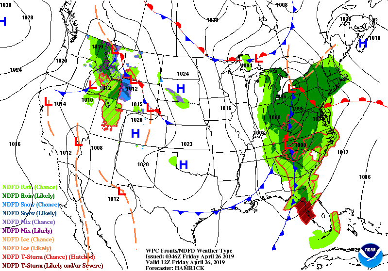
Friday, April 26, 2019

Daily Weather Briefing for Friday, April 26, 2019


Outlook

A disturbance pushing into the region will lead to scattered shower and thunderstorm activity today. A ridge building aloft will support generally quiet weather this weekend into early next week.


THREE DAY GFS FORECAST
This animated image shows a forecast of precipitation, air pressure and thickness level (cold-air damming) for three days in six-hour increments.
Green, Yellow, and Red indicate rain. Orange and Purple Indicate Freezing Rain or other freezing precipitation. Blue indicates snow.


WEATHER SPONSOR


Adams Products, a Division of Oldcastle is underwriting the daily weather briefing & public safety updates for the month.

Open 7:30 AM to 4:00 PM, M-F, located at 895 Hickory Knoll Road, Franklin, NC. Visit our Facebook page at:
https://www.facebook.com/Adams.Oldcastle.Franklin.NC/

All your masonry needs are available. Our phone number is 828.524.8545, the public is welcome, we’ll help you with your with your next project.


Weather Hazards

A Wind Advisory is in effect for Macon County for today. Scattered power outages are possible.


Wind Advisory
URGENT - WEATHER MESSAGE

National Weather Service Greenville-Spartanburg SC
1109 PM EDT Thu Apr 25 2019

...GUSTY NORTHWEST WINDS EXPECTED ACROSS THE NORTH CAROLINA AND SOUTH CAROLINA MOUNTAINS AS WELL AS PORTIONS OF NORTHEAST GEORGIA LATE FRIDAY MORNING INTO FRIDAY EVENING...

.As a cold front pushes through the area from west to east beginning Friday morning, expect a tightening pressure gradient behind this feature to allow for gusty northwesterly across the North Carolina and South carolinas mountains, as well as portions of northeast Georgia late Friday morning through Friday evening. Gusts are expected to subside and fall below criteria into Friday night as the pressure gradient relaxes.


...WIND ADVISORY REMAINS IN EFFECT FROM 11 AM TO 8 PM EDT FRIDAY...

* LOCATIONS...North Carolina mountains, South Carolinas mountains, and portions of northeast Georgia.

* HAZARDS...Gusty northwest winds.

* TIMING...Late Friday morning through Friday evening, peaking Friday afternoon.

* WINDS...Northwest 20 to 30 mph with gusts up to 50 mph.

* IMPACTS...Strong winds may blow down limbs, trees, and power lines. Scattered power outages are possible.

PRECAUTIONARY/PREPAREDNESS ACTIONS...

A Wind Advisory means that winds of 35 mph are expected. Winds this strong can make driving difficult, especially for high profile vehicles. Use extra caution.

Stay tuned to NOAA Weather Radio or your favorite source of weather information for the latest updates. Additional details can be found at www.weather.gov/gsp.


CROWDFUNDING OR DAY SPONSORSHIP OPPORTUNITIES


If you receive value from what Macon Media provides to the community, please consider becoming a supporter and contribute at least a dollar a month. Those who support Macon Media with at least a dollar a month receive early access to video of some events and meetings before they are made public on the website. Videos and news involving public safety are not subject to early access.

Patreon Subscriber History May 2014 to Present


Become a Patron!

If you have a business or event you are interested in sponsorship opportunities or underwriting coverage, send an email to editor@MaconMedia.com for more information. Serious inquiries only.

Thank You to the people who have been sending in donations and those businesses who are underwriting coverage of news and events. You have kept Macon Media online.


WEATHER FORECAST MAPS

Forecast maps for 7 am, 1 pm, and 7 pm.
[click on any image in this article to enlarge]


FRANKLIN AREA FORECAST

Today

Showers, mainly before 1pm. Highs in the mid-to-upper 60s. Winds out of the southwest 5 to 10 mph shifting to come out of the northwest 15 to 25 mph in the afternoon. Winds could gust as high as 35 mph. Chance of precipitation is 80%. New precipitation amounts between a tenth and quarter of an inch possible.

Tonight

Mostly clear, with a low in the lower 40s. Winds out of the northwest 5 to 15 mph, with gusts as high as 20 mph.

Saturday

Sunny, with a high in the mid-70s. Light and variable winds shifting to come out of the southwest 5 mph by midmorning.

Saturday Night

A 20 percent chance of showers after 1am. Mostly cloudy, with a low around 50. Winds out of the southwest 3 to 5 mph.

Sunday

A 20 percent chance of showers after 2pm. Partly sunny, with a high in the upper 70s.

Sunday Night

Partly cloudy, with a low in the upper 40s.


OTTO AREA FORECAST

Today

Showers, mainly before noon. Highs in the mid-to-upper 60s. Winds out of the southwest 5 to 10 mph shifting to come out of the northwest 15 to 20 mph in the afternoon. Winds could gust as high as 35 mph. Chance of precipitation is 80%. New precipitation amounts between a tenth and quarter of an inch possible.

Tonight

Mostly clear, with a low in the low-to-mid 40s. Winds out of the northwest 10 to 15 mph, with gusts as high as 25 mph.

Saturday

Sunny, with a high in the mid-to-upper 70s. Winds out of the northwest 5 to 10 mph shifting to come out of the southwest in the afternoon.

Saturday Night

Mostly cloudy, with a low around 50. Winds out of the southwest around 6 mph.

Sunday

A slight chance of showers before 8am, then a slight chance of showers after 2pm. Mostly sunny, with a high in the upper 70s. Chance of precipitation is 20%.

Sunday Night

Partly cloudy, with a low around 50.


HIGHLANDS PLATEAU AREA FORECAST

Today

Showers, mainly before 1pm. Patchy fog before 7am. Highs in the upper 50s. Winds out of the northwest 10 to 15 mph increasing to 20 to 25 mph in the afternoon. Winds could gust as high as 40 mph. Chance of precipitation is 80%. New precipitation amounts between a quarter and half of an inch possible.

Tonight

Mostly clear, with a low around 40. Winds out of the northwest 15 to 25 mph, with gusts as high as 40 mph.

Saturday

Sunny, with a high near 65. Winds out of the northwest 5 to 10 mph shifting out of the southwest in the afternoon.

Saturday Night

Mostly cloudy, with a low around 50. Winds out of the southwest 5 to 10 mph.

Sunday

A 20 percent chance of showers after 2pm. Mostly sunny, with a high in the mid-60s.

Sunday Night

Partly cloudy, with a low around 50.


NANTAHALA AREA FORECAST

Today

Showers, mainly before 2pm. Patchy fog before 7am. High near 60. Winds ouut of the northwest 10 to 15 mph increasing to 20 to 25 mph in the afternoon. Winds could gust as high as 45 mph. Chance of precipitation is 90%. New precipitation amounts between a quarter and half of an inch possible.

Tonight

Mostly clear, with a low around 40. Winds out of the northwest 10 to 20 mph, with gusts as high as 30
mph.

Saturday

Sunny, with a high near 70. Winds out of the northwest around 5 to 10 mph shifting to come out of the southwest in the afternoon.

Saturday Night

A 20 percent chance of showers after midnight. Mostly cloudy, with a low around 50. Winds out of the southwest 5 to 10 mph.

Sunday

A 20 percent chance of showers after 2pm. Partly sunny, with a high in the upper 60s.

Sunday Night

Partly cloudy, with a low around 50.


Macon County Almanac for April 26, 2019

Highest Temperature 91°F in Franklin in 1986
Lowest Temperature 23°F in Highlands in 1919
Greatest Rainfall 3.24 inches in Highlands in 1939
Greatest Snowfall no measurable snow has fallen on this date since records started being kept in 1872


Weather Extremes for Macon County for the month of April
Data available from 1873 to 2018

Highest Temperature 91°F in Franklin on 04-26-1986
Lowest Temperature 13°F in Highlands on 04-01-1987
Greatest Rainfall 7.00 inches in Highlands on 04-07-1895
Greatest Snowfall 9.5 inches in Franklin on 04-04-1987


Published at 2:45am on April 26, 2019

Thursday, April 25, 2019

Daily Weather Briefing for Thursday, April 25, 2019


NCDOT Scheduled to Begin Traffic Changes on Cowee Mountain

SYLVA – A contractor for the N.C. Department of Transportation will begin setting up a lane shift on U.S. 441 in Jackson County on Thursday that will provide safe travel lanes and a safe work zone when construction crews begin repairing road damage on Cowee Mountain.


Southbound traffic toward Franklin will be sent into the far right lane, while northbound traffic will be separated by a concrete median for about one mile. The shift may have a limited impact on travel times during peak hours.

Read More [LINK]

Entegra Bank Announces Merger with First Citizens Bank

Entegra Bank posted an announcement on their website Wednesday that they will be merging with First Citizens Bank.


[WFSC LINK]


PDF of Announcement [LINK]

FIRST CITIZEN WEBSITE [LINK]

Outlook

A disturbance pushing into the region will lead to scattered shower and thunderstorm activity late today into Friday. High pressure over the Southeast will support generally quiet weather this weekend
into early next week.


THREE DAY GFS FORECAST
This animated image shows a forecast of precipitation, air pressure and thickness level (cold-air damming) for three days in six-hour increments.
Green, Yellow, and Red indicate rain. Orange and Purple Indicate Freezing Rain or other freezing precipitation. Blue indicates snow.


WEATHER SPONSOR


Adams Products, a Division of Oldcastle is underwriting the daily weather briefing & public safety updates for the month.

Open 7:30 AM to 4:00 PM, M-F, located at 895 Hickory Knoll Road, Franklin, NC. Visit our Facebook page at:
https://www.facebook.com/Adams.Oldcastle.Franklin.NC/

All your masonry needs are available. Our phone number is 828.524.8545, the public is welcome, we’ll help you with your with your next project.


Weather Hazards

Hazardous weather is not expected today.


CROWDFUNDING OR DAY SPONSORSHIP OPPORTUNITIES


If you receive value from what Macon Media provides to the community, please consider becoming a supporter and contribute at least a dollar a month. Those who support Macon Media with at least a dollar a month receive early access to video of some events and meetings before they are made public on the website. Videos and news involving public safety are not subject to early access.

Patreon Subscriber History May 2014 to Present


Become a Patron!

If you have a business or event you are interested in sponsorship opportunities or underwriting coverage, send an email to editor@MaconMedia.com for more information. Serious inquiries only.

Thank You to the people who have been sending in donations and those businesses who are underwriting coverage of news and events. You have kept Macon Media online.


WEATHER FORECAST MAPS

Forecast maps for 7 am, 1 pm, and 7 pm.
[click on any image in this article to enlarge]


FRANKLIN AREA FORECAST

Today

Mostly cloudy, with a high near 80. Calm winds rising to come out of the southwest 5 to 10 mph in the afternoon.

Tonight

Showers likely, mainly after 1am. Patchy fog after 4am. Otherwise, cloudy, with a low around 55. South wind 6 to 8 mph becoming east after midnight. Chance of precipitation is 60%. New precipitation amounts between a tenth and quarter of an inch possible.

Friday

Showers and possibly a thunderstorm before noon, then showers likely. Patchy fog before 8am. High near 69. Southwest wind 6 to 11 mph becoming northwest in the afternoon. Winds could gust as high as 25 mph. Chance of precipitation is 80%. New precipitation amounts between a quarter and half of an inch possible.

Friday Night

Mostly clear, with a low around 43. North northwest wind 7 to 11 mph, with gusts as high as 30 mph.

Saturday

Sunny, with a high near 77.

Saturday Night

Partly cloudy, with a low around 49.


OTTO AREA FORECAST

Today

Mostly cloudy, with a high near 79. Calm wind becoming south southwest 5 to 8 mph in the afternoon.

Tonight

Showers likely, mainly after 1am. Patchy fog after 4am. Otherwise, cloudy, with a low around 55. South wind around 7 mph becoming east southeast after midnight. Chance of precipitation is 70%. New precipitation amounts between a tenth and quarter of an inch possible.

Friday

Showers and possibly a thunderstorm before noon, then showers likely. Patchy fog before 8am. High near 70. Southwest wind 7 to 13 mph becoming northwest in the afternoon. Winds could gust as high as 28 mph. Chance of precipitation is 80%. New precipitation amounts between a quarter and half of an inch possible.

Friday Night

Mostly clear, with a low around 44. North northwest wind 7 to 13 mph, with gusts as high as 31 mph.

Saturday

Sunny, with a high near 77.

Saturday Night

Partly cloudy, with a low around 50.


HIGHLANDS PLATEAU AREA FORECAST

Today

Isolated showers after 3pm. Mostly cloudy, with a high near 69. West northwest wind 5 to 10 mph becoming southwest in the morning. Winds could gust as high as 18 mph. Chance of precipitation is 20%.

Tonight

Showers likely, mainly after 1am. Patchy fog after 5am. Otherwise, cloudy, with a low around 51. South southwest wind around 15 mph, with gusts as high as 25 mph. Chance of precipitation is 60%. New precipitation amounts between a quarter and half of an inch possible.

Friday

Showers and possibly a thunderstorm before 2pm, then a chance of showers. Patchy fog before 8am. High near 60. West southwest wind 10 to 18 mph becoming northwest in the afternoon. Winds could gust as high as 26 mph. Chance of precipitation is 80%. New precipitation amounts between a quarter and half of an inch possible.

Friday Night

Mostly clear, with a low around 42. Breezy, with a north northwest wind 11 to 20 mph, with gusts as high as 30 mph.

Saturday

Sunny, with a high near 65.

Saturday Night

Partly cloudy, with a low around 49.


NANTAHALA AREA FORECAST

Today

Mostly cloudy, with a high near 72. Light south wind becoming south southwest 5 to 10 mph in the afternoon. Winds could gust as high as 18 mph.

Tonight

Showers, mainly after midnight. Patchy fog after 4am. Low around 52. South southwest wind around 11 mph, with gusts as high as 21 mph. Chance of precipitation is 80%. New precipitation amounts between a quarter and half of an inch possible.

Friday

Showers and possibly a thunderstorm before noon, then showers likely. Patchy fog before 8am. High near 62. West southwest wind 9 to 16 mph becoming northwest in the afternoon. Winds could gust as high as 25 mph. Chance of precipitation is 80%. New precipitation amounts between a quarter and half of an inch possible.

Friday Night

Mostly clear, with a low around 42. North northwest wind 11 to 16 mph, with gusts as high as 31 mph.

Saturday

Sunny, with a high near 69.

Saturday Night

Partly cloudy, with a low around 49.


Macon County Almanac for April 25, 2019

Highest Temperature 88°F in Franklin in 1960
Lowest Temperature 25°F in Highlands in 1930
Greatest Rainfall 4.85 inches in Highlands in 1881
Greatest Snowfall 6.0 in Highlands in 1910


Weather Extremes for Macon County for the month of April
Data available from 1873 to 2018

Highest Temperature 91°F in Franklin on 04-26-1986
Lowest Temperature 13°F in Highlands on 04-01-1987
Greatest Rainfall 7.00 inches in Highlands on 04-07-1895
Greatest Snowfall 9.5 inches in Franklin on 04-04-1987


Published at4:00am on April 25, 2019