


Evacuations are already underway in parts of Louisiana (including New Orleans) and may come soon for parts of Texas and other portions of Louisiana today.
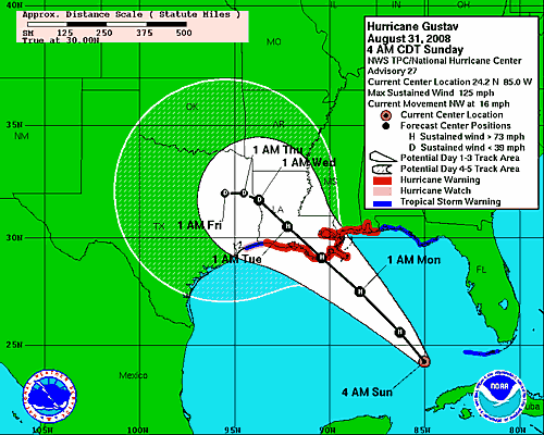
Here is the latest advisory issued by the National Hurricane Center regarding Hurricane Gustav:
WTNT22 KNHC 310856Visit NHC for the latest advisories.
TCMAT2
HURRICANE GUSTAV FORECAST/ADVISORY NUMBER 27
NWS TPC/NATIONAL HURRICANE CENTER MIAMI FL AL072008
0900 UTC SUN AUG 31 2008
AT 4 AM CDT...0900 UTC...A HURRICANE WARNING IS ISSUED FOR THE
NORTHERN GULF COAST FROM CAMERON LOUISIANA EASTWARD TO THE
ALABAMA-FLORIDA BORDER...INCLUDING THE CITY OF NEW ORLEANS AND
LAKE PONTCHARTRAIN. A HURRICANE WARNING MEANS THAT HURRICANE
CONDITIONS ARE EXPECTED WITHIN THE WARNING AREA WITHIN THE NEXT 24
HOURS. PREPARATIONS TO PROTECT LIFE AND PROPERTY SHOULD BE RUSHED
TO COMPLETION.
AT 4 AM CDT...0900 UTC...A TROPICAL STORM WARNING IS ISSUED FROM
EAST OF THE ALABAMA-FLORIDA BORDER TO THE OCHLOCKONEE RIVER....AND
FROM WEST OF CAMERON LOUISIANA TO JUST EAST OF HIGH ISLAND TEXAS.
A TROPICAL STORM WARNING MEANS THAT TROPICAL STORM CONDITIONS ARE
EXPECTED WITHIN THE WARNING AREA WITHIN THE NEXT 24 HOURS.
AT 4 AM CDT...0900 UTC...THE GOVERNMENT OF CUBA HAS DISCONTINUED ALL
WARNINGS AND WATCHES FOR CUBA.
A HURRICANE WATCH REMAINS IN EFFECT FROM WEST OF CAMERON LOUISIANA
TO JUST EAST OF HIGH ISLAND TEXAS. A HURRICANE WATCH MEANS THAT
HURRICANE CONDITIONS ARE POSSIBLE WITHIN THE WATCH AREA...GENERALLY
WITHIN 36 HOURS.
A TROPICAL STORM WARNING REMAINS IN EFFECT FOR THE LOWER FLORIDA
KEYS WEST OF THE SEVEN MILE BRIDGE TO THE DRY TORTUGAS.
The storm graphics of Gustav are below:
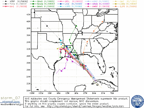
And here are the Spaghetti Models for Gustav:
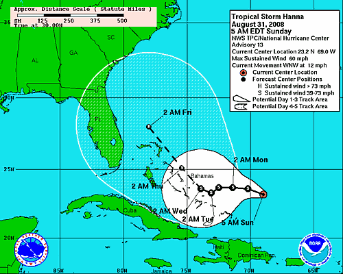
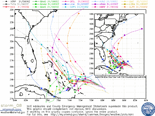
Tropical Storm Hanna is bearing down on The Bahamas, and computer models vary wildly about her path past 2 AM Tuesday, with the NHC model showing a turn to the northwest. Here are the graphics regarding Hanna:
You can see the latest National Advisories for the various watches and warnings issued nation-wide, and along the gulf coast.


1 comments :
Here's a storm comment that should be spread throughout North Carolina:
Dan Fowler, former chairman of the DNC is joking about what a great thing it is that a hurricane is hitting New Orleans while the GOP convention is on. "God is on our side" is a quote.
http://www.youtube.com/watch?v=TrBus8ORR78
Do you think that he would feel any different about it if North Carolina was getting hit?
Post a Comment