Notice

I am working on the template of this blog today in order to chase down some problems that have developed with my template and widgets.

Macon County Commissioners

Coverage of the meetings of the Macon County Board of County Commissioners.

Franklin Town Board of Aldermen

Coverage of the meetings of the Franklin Town Board of Aldermen.

Macon County School Board

Coverage of the meetings of the Macon County School Board.

Photoblog

Photos from my photoblog.

nullspace for future use

nullspace for future use

About

Showing posts with label Maps. Show all posts

Thursday, March 14, 2019

Map Developer Updates Street View Maps
Will Include Information on Roundabout Construction


A mapping car equipped with multiple cameras from Here technologies drove through Franklin earlier this afternoon in a quest to capture regional roads in North Carolina and update points of interest that have had recent construction and verify user changes to their maps. The driver said that he was in Franklin specifically to capture the new bridge and the mark the location of the new roundabout construction to include in their maps. He said the maps would also be updated after the construction of the roundabouts was complete. The driver said the company had their own maps that could be accessed via a laptop or desktop, as well as apps for smartphones that included voice navigation so drivers could get directions hands-free while driving. Their maps also include a traffic layer that uses data collected from app users to determine areas where traffic congestion has slowed down traffic.


Following is a list of some of their consumer-level products:

WeGo Map [LINK]

Map Creator [LINK]

Android App [LINK] 


Apple App [LINK]


About the Company

Here Technologies is a company that provides mapping and location data and related services to individuals and companies. Here captures location content such as road networks, buildings, parks and traffic patterns. It then sells or licenses that mapping content, along with navigation services and location solutions to other businesses such as Alpine, Garmin, BMW, Oracle and Amazon.com. In addition, Here provides platform services to smartphones. It provides location services through its own Here applications, and also for GIS and government clients and other providers, such as Bing, Facebook and Yahoo! Maps and has maps in nearly 200 countries, offers voice guided navigation in 94 countries, provides live traffic information in 33 countries and has indoor maps available for about 49,000 unique buildings in 45 countries. The company is also working on self-driving technology.

Source: Wikipedia


CROWDFUNDING OR DAY SPONSORSHIP OPPORTUNITIES


If you receive value from what Macon Media provides to the community, please consider becoming a supporter and contribute at least a dollar a month. Those who support Macon Media with at least a dollar a month receive early access to video of some events and meetings before they are made public on the website. Videos and news involving public safety are not subject to early access.

Patreon Subscriber History May 2014 to Present


Become a Patron!

If you have a business or event you are interested in sponsorship opportunities or underwriting coverage, send an email to editor@MaconMedia.com for more information. Serious inquiries only.

Thank You to the people who have been sending in donations and those businesses who are underwriting coverage of news and events. You have kept Macon Media online.

Published at 4:30pm on Thursday, March 14, 2019


Sunday, December 31, 2017

Tools Motorists can use to Avoid Delays and Hazards on the Roads


Google Traffic Map showing the traffic jam after the August 21, 2017, Solar Eclipse


Macon Media uses several tools to find out where traffic is congested or blocked during accidents, heavy traffic flow periods and hazardous weather events in order to share the information with motorists. Among them are the traffic layer in Google Maps and the Waze Traffic App for desktop and mobile devices. These are effective tools that anyone can use to travel more safely on the roads and use to avoid delays, hazards and accidents so you can get to where you want to be as safely as possible and make better time when commuting.


Traffic congestion marked on a Google Traffic Layer Map shared by Macon Media on November 11, 2017


Google Maps Traffic Layer

The Google Maps Traffic Layer works by analyzing the GPS-determined locations and speeds transmitted to Google by a large number of mobile phone users. By calculating the speed of users along a length of road, Google is able to generate a live traffic map. This is so accurate, it even shows where vehicles are stopped for traffic lights, automobile acidents (Macon Media has even identified accidents via the map before it was dispatched by the local EOC). It can also identify the locations of traffic stops and checkpoints. Google recently acquired the Waze traffic app and utilizes information added by Waze Users such as indicating where accidents or speed traps are located to the traffic map layer. Google is also developing a system to warn traffic users of protests that may delay travel or pose a hazard to travel and warn of active shooter or terrorist incidents and active crime scenes so motorists can safely avoid those situations.

The colors indicate the speed of traffic on the road. Green means traffic is moving along as usual and there is normal traffic. Orange means there's heavy traffic and it is moving a bit slower than usual traffic. Red means there are traffic delays. The more red, the slower the speed of traffic on the road.

Check it out for yourself at this LINK.


This map is centered on Franklin, NC. You can move the map to other areas you are interested in seeing. Note that the traffic layer is less effective when there are not many people on the roads and in areas where there is no cell phone service.


Waze Users (also called Wazers) mark the location of an accident and the extent of traffic congestion in Otto, NC on December 27, 2017

Waze

Waze is an app for mobile devices that allows motorists to contribute data to a database that is then displayed on a map on your mobile device (or on the desktop if you have the desktop version). The app takes data from your phone that tracks your location and speed and displays it on a map for you. Data from other users is also displayed. You can see where nearby Waze Users are located and can see messages they add to the map that indicate hazards to traffic, like potholes, icy conditions or trees in the road and cars stopped on the shoulder and can post photos of traffic accidents and their location so you can slow down or take an alternate route. If a Waze User sees a speed trap or notes a police presence, they can add that to the map, too so other motorists will slow down and drive more safely. Motorists and state transportation officials also add information about road closures so motorists can plan a better route to their destination. The app can even locate the cheapest fuel prices near you. Earlier this year, information about carpool lanes and specialized routes for motorcyclists was added. An add-on is also available that will notify you when you are driving through a high-crime area.

You can get the Waze at at the following locations:

Google Play
https://play.google.com/store/apps/details?id=com.waze

Apple Devices
https://itunes.apple.com/app/apple-store/id323229106

Waze Desktop Live Map 

(uses data from your browser to find your location. Zoom in to see details and click icons for more information)
https://www.waze.com/livemap

CROWD FUNDING OR DAY SPONSORSHIP OPPORTUNITIES

If you receive value from what Macon Media provides to the community, please consider becoming a supporter and contribute at least a dollar a month.

If you have a business or event you are interested in sponsorship opportunities or underwriting coverage, send an email to editor@MaconMedia.com for more information.
Serious inquiries only. Macon Media rewards early sponsors/underwriters with lifetime guaranteed low rates while newer sponsors/underwriters pay higher rates based on the date they first support Macon Media.

Thank You to the people who have been sending in donations and those businesses who are underwriting coverage of news and events. You have kept Macon Media online.

You can find out more information on how to do that and some of what I plan to accomplish if I reach certain levels of funding at https://www.patreon.com/MaconMedia

Published at 5:15 am on December 31, 2017

Be kind to one another.


Monday, December 10, 2012

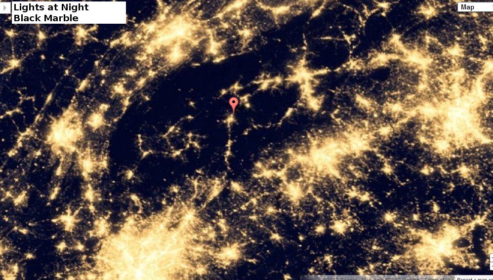
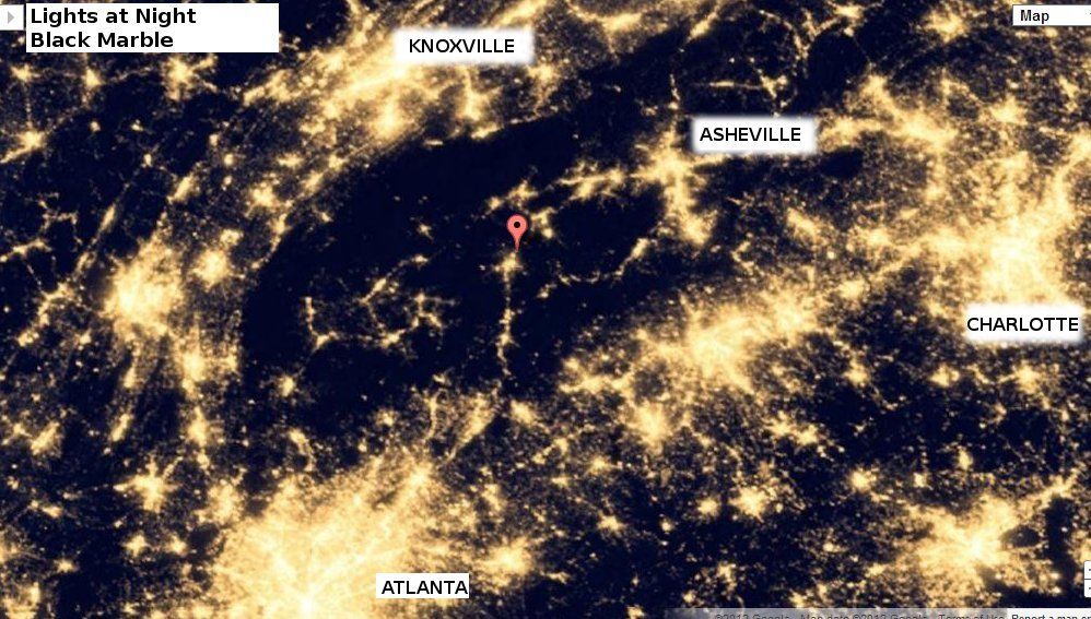
Black Marble added to Google Maps

Click image to Embiggen
Google Earth has added the recently released Earth at Night 2012 to Google Maps and you can explore the imagery to see how your area looks at night.

The above photo is of the area where I live, with my residence marked with a red marker. The photo below is an annotated version of that with the major cities labelled.

Check it out for yourself at Google Maps.


Source: Google Maps


**update** 
More info, including the KML File, is available at the Earth Observatory.


Click image to Embiggen