Notice

I am working on the template of this blog today in order to chase down some problems that have developed with my template and widgets.

Macon County Commissioners

Coverage of the meetings of the Macon County Board of County Commissioners.

Franklin Town Board of Aldermen

Coverage of the meetings of the Franklin Town Board of Aldermen.

Macon County School Board

Coverage of the meetings of the Macon County School Board.

Photoblog

Photos from my photoblog.

nullspace for future use

nullspace for future use

About

Showing posts with label April 2020 Weather. Show all posts

Friday, May 1, 2020

Daily Weather Briefing for Friday, May 01, 2020
COVID-19 Update Included


OUTLOOK

A strong cold front will cross the area and will bring rain and isolated thunderstorms today into tonight. Cool and breezy conditions are expected behind the front Thursday into Friday. Warm and dry high pressure will settle over the region and provide a significant warmup late in the weekend and early next week.

County to rescind Emergency Regulations that go beyond the state restrictions on May 8th, to follow state plan to re-open in phases. [LINK]

---BEGIN SPONSOR SEGMENT ---


Weather Sponsor


Adams Products, a Division of Oldcastle is underwriting the daily weather briefing & public safety updates for the month.

Open 7:30 AM to 4:00 PM, M-F, located at 895 Hickory Knoll Road, Franklin, NC. Visit our Facebook page at:
https://www.facebook.com/Adams.Oldcastle.Franklin.NC/

All your masonry needs are available. Our phone number is 828.524.8545, the public is welcome, we’ll help you with your next project.


---END SPONSOR SEGMENT---


General Forecast Through Friday

Today

Sunny, breezy with highs ranging from the mid-50s to the mid-60s. Winds out of the northwest winds 15 to 20 mph with gusts up to 35 mph. A wind field will cross the county between 9am and 6pm today.

Tonight

Mostly clear. Lows ranging from the mid-40s to the upper 30s. Wind chills may dip into the 30s in most locations with some isolated higher elevations seeing wind chills in the upper 20s. Winds out of the northwest 10 to 15 mph.

Saturday

Mostly sunny. Highs ranging from the mid-60s to the lower 70s. Winds out of the west 5 to 10 mph.

Saturday Night

Mostly clear. Lows ranging from the lower 50s to the upper 40s. Winds out of the west 5 to 10 mph.

Sunday

Mostly sunny. Highs ranging from the mid-60s to the upper 70s and few locations could creep into the lower 80s if they are sheltered from the wind. Winds out of the west 10 to 15 mph.

Sunday Night

Partly cloudy in the evening, then mostly cloudy with a chance of showers after midnight. Lows ranging from the upper 50s to the lower 50s. Chance of rain 40 percent.


Hazards

Hazardous weather is not anticipated for today. Brisk winds may cause an isolated power outage. Keep an eye on your plastic lawn chairs.


End Daily Weather Segment


Begin COVID-19 AM Update Segment


Several curated videos and links to articles are posted below to allow you to follow the course of humanity's response to this global pandemic.

ABOVE THE FOLD

Stats for Friday, May 01, 2020, at 5:30am per CoronaWiki.org

Earth

3,325,206 Known Infections
234,617 Known Deaths

USA

1,095,304 Known Infections
63,871 Known Deaths

North Carolina

10,754 Known Infections
406 Known Deaths

Macon County

3 Known Infections
1 Known Death


COVID-19 Update

About Seven-in-Ten U.S. Adults Say They Need to Take Breaks From COVID-19 News [LINK]

Dr. Fauci says coronavirus vaccine could be widely available by January if "things fall in the right place" [LINK]

Amazon reports earnings, plans to spend all Q2 profits ($4B) on coronavirus response [LINK]

No income and number 88,000 in line: This is what it's like to be unemployed in America [LINK]

CLUSTER BOMBS Coronavirus map shows the 22 hotspots where cases could explode as eight states lift lockdowns [LINK]

Top coronavirus model predicts 100,000 Americans dead by the end of this summer's first wave [LINK]

Hundreds of protesters, some carrying guns in the state Capitol, demonstrate against Michigan's emergency measures [LINK]

Protesters argue with police inside Michigan Capitol building


Nurses to anti-lockdown activists: My life's on the line. Go home [LINK]

Covid-19: Why is America’s death toll so high? | The Economist


The CDC website [LINK] reports 9,948 people in North Carolina are infected, 354 have died, and infections are widespread, the NCDHHS website [LINK] reports 10,509 confirmed cases, 546 hospitalized and 378 deaths in the state. The Johns Hopkins Dashboard [LINK] reports 10,754 people infected and 406 deaths (these include non-residents located in NC).

Resources for Reliable Information about the Corona Virus (COVID-19) [LINK]


Videos from Government and Bureaucratic Types

World Health Organization
The latest WHO Briefing was April 27th


White House
There was no briefing yesterday, here are President Trump Delivers Remarks on Protecting America’s Seniors


North Carolina

English


Spanish


Videos From Medical Professionals


Dr. John Campbell

Thursday 30th April, Part One


Part Two


Coronavirus Pandemic Update 59: Dr. Seheult's Daily Regimen (Vitamin D, C, Zinc, Quercetin, NAC)


Coronavirus Pandemic Update 64: Remdesivir COVID-19 Treatment Update


Will 60% Get Coronavirus? w Stephen Fry


Doctor Mike Hansen: How Coronavirus (COVID19) Kills Some People (But Not Others)


GENERAL ARTICLES

Maryland governor says coronavirus tests acquired from South Korea under guard at undisclosed location to protect the tests from seizure by federal government [LINK]

Japanese island suffering second wave of coronavirus after lifting lockdown too early [LINK]

Fauci warns reopening states: 'You can't just leap over things' [LINK]

Whole Foods offering free masks to all customers nationwide [LINK]

Florida stops releasing medical examiners’ coronavirus death counts after they report higher total [LINK]

'She has superhuman DNA:' 101-year-old woman beats COVID-19, has survived 2 pandemics and cancer [LINK] 


Texas reports most deaths in a day from COVID-19 as Gov. Abbott prepares to drop stay-home order [LINK]

$2m worth of wagyu beef donated to US food banks by family farm [LINK]

Chinese Embassy in France Mocks U.S. Coronavirus Response With 'Once Upon a Virus' Animated Video [LINK]


Video from News Outlets

Coronavirus Pandemic (full film) | FRONTLINE


NBC Nightly News Broadcast (Full) - April 30th, 2020 | NBC Nightly News


30 million unemployment claims filed in last 6 weeks


White House reveals plan to fast-track vaccine timeline | WNT


CROWDFUNDING OR DAY SPONSORSHIP OPPORTUNITIES


If you receive value from what Macon Media provides to the community, please consider becoming a supporter and contribute at least a dollar a month. Those who support Macon Media with at least a dollar a month receive early access to video of some events and meetings before they are made public on the website. Videos and news involving public safety are not subject to early access.


Become a Patron!

Or, if you prefer Pay Pal, try PayPal.me/MaconMedia


Published at 5:40am on Friday, May 01, 2020


Thursday, April 30, 2020

Daily Weather Biefing for Thursday, April 30, 2020


OUTLOOK

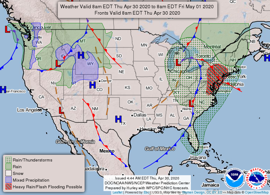
A strong cold front will cross the area and will bring rain and isolated thunderstorms today into tonight. Cool and breezy conditions are expected behind the front Thursday into Friday. Warm and dry high pressure will settle over the region and provide a significant warmup late in the weekend and early next week.

Macon County to rescind Emergency Regulations that go beyond the state restrictions on May 8th, to follow state plan to re-open in phases. [LINK]

---BEGIN SPONSOR SEGMENT ---


DAY SPONSOR

Macon Media is being underwritten today by Franklin Health & Fitness, home of #ResultsForEveryone, and the FREE 7-Day Guest Pass.

During this public health emergency, Franklin Health and Fitness has made the difficult decision to temporarily close due to the continued risk surrounding COVID-19. To see updates related to COVID-19, please click: http://franklinhealthandfitness.com

There are also On-Demand Fitness Videos located at https://franklinhealthandfitness.com/blog/


Weather Sponsor


Adams Products, a Division of Oldcastle is underwriting the daily weather briefing & public safety updates for the month.

Open 7:30 AM to 4:00 PM, M-F, located at 895 Hickory Knoll Road, Franklin, NC. Visit our Facebook page at:
https://www.facebook.com/Adams.Oldcastle.Franklin.NC/

All your masonry needs are available. Our phone number is 828.524.8545, the public is welcome, we’ll help you with your next project.


---END SPONSOR SEGMENT---


General Forecast Through Friday

Today

Patchy fog this morning. Mostly cloudy with a 20 percent chance of showers. Highs ranging from the upper 50s to the lower 60s. Winds out of the northwest 10 to 15 mph with winds gusting to 20 to 25 mph between 3pm and 8pm.

Tonight

Mostly cloudy with a 40 percent chance of showers. Lows ranging from the lower 40s to the upper 30s. Winds out of the northwest 10 to 15 mph with gusts up to 25 mph before 8pm.

Friday

Mostly sunny. Highs ranging from the upper 50s to the lower 60s. Winds out of the northwest 10 to 15 mph with gusts up to 30 mph.

Friday Night

Mostly clear. Lows ranging from the mid-40s to the upper 30s. Winds out of the northwest 10 to 15 mph with gusts up to 25 mph, shifting to come out of the north around 5 mph after midnight.

Saturday

Mostly sunny. Highs ranging from the upper 60s to the lower 70s. Winds out of the northwest winds around 5 mph.

Saturday Night

Mostly clear. Lows around 50.


Hazards

Hazardous weather is not anticipated for today.


End Daily Weather Segment


CROWDFUNDING OR DAY SPONSORSHIP OPPORTUNITIES


If you receive value from what Macon Media provides to the community, please consider becoming a supporter and contribute at least a dollar a month. Those who support Macon Media with at least a dollar a month receive early access to video of some events and meetings before they are made public on the website. Videos and news involving public safety are not subject to early access.


Become a Patron!

Or, if you prefer Pay Pal, try PayPal.me/MaconMedia


Published at 5:50am on Thursday, April 30, 2020


Wednesday, April 29, 2020

Daily Weather Briefing for Wednesday, April 29, 2020


OUTLOOK

A strong cold front will cross the area and will bring rain and isolated thunderstorms today into tonight. Cool and breezy conditions are expected behind the front Thursday into Friday. Warm and dry high pressure will settle over the region and provide a significant warmup late in the weekend and early next week.

News Brief


Field Report from the North Carolina Geological Survey Regarding Recent Debris Flows [LINK] 


Firefighters Respond to Man Trapped at Bust Your Butt Falls [LINK]

Mission Health Announces Phased Approach for Caring for Non-COVID-19 Patients  [LINK] 

Macon County Economic Development Commission Ready to Assist Businesses in Need [LINK] 


---BEGIN SPONSOR SEGMENT ---

Weather Sponsor


Adams Products, a Division of Oldcastle is underwriting the daily weather briefing & public safety updates for the month.

Open 7:30 AM to 4:00 PM, M-F, located at 895 Hickory Knoll Road, Franklin, NC. Visit our Facebook page at:
https://www.facebook.com/Adams.Oldcastle.Franklin.NC/

All your masonry needs are available. Our phone number is 828.524.8545, the public is welcome, we’ll help you with your next project.


---END SPONSOR SEGMENT---


General Forecast Through Friday

Today

A slight chance of rain before 1pm, then a chance of showers between 1pm and 4pm, then showers likely and possibly a thunderstorm after 4pm. Some of the storms could produce heavy rainfall. Increasing clouds, with highs ranging from the lower 60s to the lower 70s. Light winds out of the southeast increasing to 5 to 10 mph by midmorning. Winds could gust as high as 20 mph. ain chances increase from slight in the morning to moderate chances in the afternoon and likely in the mid and late afternoon. Rainfall amounts between a quarter and half of an inch possible.

Tonight

Patchy fog between midnight and 3am. Lows in the 40s. Calm winds in the early evening increasing to come out of the northwest around 5 mph. The chance of precipitation is 100%. Some of the storms could produce heavy rainfall. New precipitation amounts between three quarters and one inch possible.

Thursday

Partly sunny, with highs ranging from the 50s to near 60. Calm winds in the morning increasing to come out of the northwest 5 to 10 mph in the afternoon. A 40 percent chance of showers. New precipitation amounts of less than a tenth of an inch possible.

Thursday Night

Mostly cloudy, with lows around 40. Winds of the northwest 5 to 10 mph. A 30 percent chance of showers.

Friday

Mostly sunny, with highs ranging from the upper 50s to the mid-60s. Winds out of the northwest 5 to 15 mph, with gusts as high as 30 mph. A 20 percent chance of showers before noon.

Friday Night

Partly cloudy, with lows in the 40s.


Hazards

A slow-moving squall line with embedded strong to isolated severe thunderstorms is likely to push through the region this afternoon into tonight with damaging wind and an isolated tornado the main threats. Periods of heavy rain along and ahead of the squall line may result in minor flooding of small streams and urban areas.


End Daily Weather Segment


CROWDFUNDING OR DAY SPONSORSHIP OPPORTUNITIES


If you receive value from what Macon Media provides to the community, please consider becoming a supporter and contribute at least a dollar a month. Those who support Macon Media with at least a dollar a month receive early access to video of some events and meetings before they are made public on the website. Videos and news involving public safety are not subject to early access.


Become a Patron!

Or, if you prefer Pay Pal, try PayPal.me/MaconMedia


Published at 5:55am on Wednesday, April 29, 2020


Tuesday, April 28, 2020

Field Report from the North Carolina Geological Survey Regarding Recent Debris Flows


The North Carolina Geological Survey has completed a field report for the Macon County Emergency Management and a copy of the report has been posted below in the interest of transparency.


Preliminary Field Report
North Carolina Geological Survey
April 24, 2020

At the request of the Macon County Emergency Management Department a team of geologists from the North Carolina Geological Survey conducted field reviews and Unmanned Aerial Systems (UAS) flights on April 13, 14, 15, and 17, 2020 of the areas affected by the debris flows of April 13, 2020. Based on our investigations to date, we offer the preliminary observations and guidance as follows. Additional information may become available as our studies continue.

Considerations for all locations impacted by the April 13, 2020 debris flows:

• Our assessment of the areas did not identify any immediate threats to life safety that would prohibit the occupancy of structures other than those deemed structurally unsafe to occupy by the jurisdictional building inspector. Conditions and circumstances may change, and this assessment in NO way implies that other slope failures in the affected areas would not occur in the future.

• Residual debris could continue to affect the areas particularly after future heavy rainfall events, including runoff and sedimentation from the exposed slopes.

• Because the slopes are over-steepened in the debris flow source areas, the margins of these slopes are unsafe.

• Trees that are leaning, undercut, or have exposed roots as a result of the debris flow activity should be considered hazardous. These trees should be removed where they are near residences or roads.

Valley View Trail and Chavis Road Debris Flows

The debris flows at these locations damaged roads, private properties, and severely damaged at least two residences. We observed groundwater discharge in the slope failure initiation zones at both locations, as well as evidence for surface water runoff from areas upslope during our April 13, 2020 site visit. Increased groundwater and surface water flow in response to the heavy rainfall were factors that likely contributed to the failures. Prior ground disturbance from human activity in the debris flow source areas appeared to be minimal.

Our assessment of the areas did not identify any immediate threats to life safety that would prohibit the occupancy of structures other than those deemed structurally unsafe to occupy by the County building inspector. Conditions and circumstances may change, and this assessment in NO way implies that other slope failures in these areas would not occur in the future. Anecdotal reports by residents indicate that a slope failure occurred in the Valley View Trail area about 15 to 20 years ago.

Additional soil material could fail along the over-steepened slopes in the debris flow source areas. The material would likely move downslope along drainage ways, especially in response to heavy rainfall. Runoff and sediment from the exposed slopes could also affect travel along roads and driveways, and impede or prevent vehicular access in some instances. The debris flow deposits can be thick, wet and contain woody debris and other objects caught up in the flows; therefore, extreme caution is advised for foot traffic in these areas.

Monitoring the steep slopes in the debris flow source areas for any development of new ground cracks that could indicate the enlargement of the unstable areas is advisable. Because the slopes are over-steepened in the debris flow source areas, the margins of these slopes are unsafe, particularly for children. We observed what appeared to be pre-existing, past-active, ground displacement (scarps) in the area immediately upslope for the source area of the Chavis Road debris flow. New ground movement along these scarps may indicate enlargement of the present unstable area.

Dobson Mountain Debris Flow

The debris flow on the northwest-facing slopes of Dobson Mountain is a major event directly impacting an area of about 16.8 acres along a tributary to Cartoogechaye Creek. We understand that the inlet for the town of Franklin’s water supply is in Cartoogechaye Creek. The path of the debris flow is approximately 4,000 feet long as measured along the slope gradient, and is 250-300 feet wide in places. Unvegetated soil subject to continued erosion and sedimentation is exposed along essentially the entire 16.8 acre path. The debris flow initiated on slopes where evidence was not observed of significant road construction or site grading, such as cut and/or fill slopes. Our field investigation of the source area indicates that it is an area of past debris slide activity. Older debris flow deposits of an unknown age were also observed in the debris flow runout zone along the stream banks on the east side of the commercial facility at 595 Maxwell Home Road.

Initial estimates indicate there is a substantial amount of unstable slide debris remaining near the debris flow source area, possibly on the order of 12,000 cubic yards or more. Ponded water present in this area was visible in our April 13, 2020 UAS image, and verified in our April 14, 2020 field investigation. There is a significant potential for future debris flow activity related to this unstable mass in the source area.

There are no known residential buildings in the path of the April 13, 2020 debris flow, or possible future debris flow activity in the same drainage. The commercial facility at 595 Maxwell Home Road was impacted by the April 13th event, and extreme caution should be used in the area where debris flow deposits are piled up behind the main building. This property could be adversely affected in the event of future major debris flows. As our resources allow, the North Carolina Geological Survey is available to provide technical assistance in an Emergency Watershed Protection grant application process, and participate in discussions of possible mitigation measures as they may relate to geologic processes and materials.

Turkey Pen and Enchanted Mountain - Potts Branch Watershed

Four debris flows were identified in the Turkey Pen and Enchanted Mountain areas of the Potts Branch watershed on the southeast-facing slopes of Dobson Mountain. No imminent threat to residential structures was identified in this area.

The largest debris flow damaged the residential buildings at 504 Turkey Pen Road, and caused substantial damage to Turkey Pen Road. Our April 17, 2020 investigation of the debris flow track and source area indicated that it originated on natural, forested slopes where evidence road construction or site grading, such as cut and/or fill slopes was not observed. Oversteepened soil material remains in the scarp of the source area which will likely result in localized instability. Anecdotal reports by residents indicate that a slope failure like a debris flow occurred in the lower Turkey Pen Road area about 15 to 20 years ago. We identified three debris flows in the Enchanted Mountain area that resulted in damage to Enchanted Mountain Road, and to a residential well house and well head adjacent to the road. Future movement of exposed soil from the debris flow path above that location could potentially impact the well head.

Road-related slope failures on Trimont Mtn. Road and Doghobble Drive (Wildflower) Road-related failures at both locations mobilized into rapidly moving debris flows that impacted properties outside of the road corridors. The over-steepened slopes immediately below the road travel ways are unstable, and the potential for further failures, and subsequent loss of the travel way exists until the slopes are adequately repaired. Both locations are generally unsafe for vehicular traffic for the conditions observed on our field visits to Trimont Mountain Road on April 15th and Doghobble Drive on April 17th, 2020.

Evidence of groundwater seepage was observed in the slope failure initiation zones at both locations, and was likely a factor contributing to the failures. Road repair methods and materials should take into account the adequate long-term management of groundwater and surface water at both locations. The culvert was plugged at the Trimont Mountain road location, which likely resulted in storm water traveling over the roadway and onto the road embankment contributing to the failure. It is advisable to replace the existing culvert with a larger diameter one that is better positioned to capture inlet flow, along with adequate erosion protection at the outlet. Ideally, road-related slope repairs at both locations would be done under the guidance of a licensed geotechnical engineer. The debris flows stripped vegetation and surface soil along their paths. Revegetation of the track areas for erosion control is advisable to reduce further erosion and stream sedimentation.

The road failure on Trimont Mountain Road caused sedimentation into the impoundment behind Trimont Mountain dam (LQS Macon-044). A DEQ Land Quality Section inspector visited the dam on Friday, April 17, 2020 and determined that the dam itself was not impacted by the debris flow. The impoundment did receive sediment but there were no impacts to dam-related infrastructure from the debris flow. The Trimont Mountain road failure is upslope of the Trimont Mountain Dam; therefore it is important that the road repair is stable over the long term.

Published at 5:35pm on Tuesday, April 28, 2020


Daily Weather Briefing for Tuesday, April 28, 2020


OUTLOOK

Seasonably cool and breezy conditions are expected across our region today. Expecting a bit milder temperatures on Tuesday. The next shot at widespread rain will arrive by late Wednesday as a cold front reaches our area.


---BEGIN SPONSOR SEGMENT ---

Weather Sponsor


Adams Products, a Division of Oldcastle is underwriting the daily weather briefing & public safety updates for the month.

Open 7:30 AM to 4:00 PM, M-F, located at 895 Hickory Knoll Road, Franklin, NC. Visit our Facebook page at:
https://www.facebook.com/Adams.Oldcastle.Franklin.NC/

All your masonry needs are available. Our phone number is 828.524.8545, the public is welcome, we’ll help you with your next project.


---END SPONSOR SEGMENT---


General Forecast Through Thursday

Today (Frost Advisory until 9am)

Mostly sunny. Highs ranging from the mid-60s to the lower 70s. Winds out of the southwest 5 to 10 mph.

Tonight

Partly cloudy in the evening, then becoming mostly cloudy. Lows ranging from the lower 50s to the mid-40s. Winds out of the south 5 to 10 mph.

Wednesday

A chance of rain in the morning, then showers with a chance of thunderstorms in the afternoon. Highs ranging from the upper 50s to the upper 60s. Winds out of the south 10 to 15 mph with gusts up to 40 mph. Chance of rain near 100 percent. Rainfall amounts of around an inch possible.

Wednesday Night

Showers with a chance of thunderstorms in the evening, then showers likely after midnight. Lows ranging from the mid-40s to the upper 30s. Winds out of the southwest 5 to 10 mph. Gusts up to 30 mph in the evening. Chance of rain 90 percent.

Thursday

Partly sunny with a 50 percent chance of showers. Highs in the 50s. Winds out of the west 5 to 10 mph. Gusts up to 25 mph in the afternoon.

Thursday Night

Partly cloudy. A chance of rain showers in the evening. Lows ranging from around 40 to the mid-30s. Chance of rain 40 percent.


Hazards


A Frost Advisory is in effect until 9am this morning for scattered frost. Other than that, hazardous weather is not expected today.


End Daily Weather Segment


CROWDFUNDING OR DAY SPONSORSHIP OPPORTUNITIES


If you receive value from what Macon Media provides to the community, please consider becoming a supporter and contribute at least a dollar a month. Those who support Macon Media with at least a dollar a month receive early access to video of some events and meetings before they are made public on the website. Videos and news involving public safety are not subject to early access.


Become a Patron!

Or, if you prefer Pay Pal, try PayPal.me/MaconMedia


Published at 5:45am on Tuesday, April 28, 2020


Monday, April 27, 2020

Daily Weather Briefing for Monday, April 27, 2020


OUTLOOK

Seasonably cool and breezy conditions are expected across our region today. Expecting a bit milder temperatures on Tuesday. The next shot at widespread rain will arrive by late Wednesday as a cold front reaches our area.


---BEGIN SPONSOR SEGMENT ---

Weather Sponsor


Adams Products, a Division of Oldcastle is underwriting the daily weather briefing & public safety updates for the month.

Open 7:30 AM to 4:00 PM, M-F, located at 895 Hickory Knoll Road, Franklin, NC. Visit our Facebook page at:
https://www.facebook.com/Adams.Oldcastle.Franklin.NC/

All your masonry needs are available. Our phone number is 828.524.8545, the public is welcome, we’ll help you with your next project.


---END SPONSOR SEGMENT---


General Forecast Through Monday

Today

Sunny. Highs in the 60s. Winds out of the northwest 10 to 15 mph. Gusts up to 30 mph in the morning.

Tonight

Mostly clear. Lows in the 40s. Winds out of the northwest 5 to 10 mph.

Tuesday

Mostly sunny. Highs in the 60s to around 70. Winds out of the southwest around 5 mph.

Tuesday Night

Partly cloudy in the evening, then mostly cloudy with a chance of showers after midnight. Lows in the 40s up to around 50. Winds out of the south around 5 mph. Chance of rain 40 percent.

Wednesday

Showers. Highs in the 60s. Chance of rain 90 percent.

Wednesday Night

Showers likely with a chance of thunderstorms in the evening, then a chance of showers after midnight. Lows in the 40s. Chance of rain 70 percent.


Hazards

Hazardous weather is not expected today.


End Daily Weather Segment


Begin COVID-19 Update


---BEGIN SPONSOR SEGMENT ---

DAY SPONSOR

Carrion Tree Service is underwriting Macon Media for today. they are a fully licensed and insured tree service, specializing in dangerous tree removal, view clearing, pruning, and crane services with a 24 Hour emergency response.

Their phone number is 371-4718.

They can handle all your tree removal needs in good or bad weather.


---END SPONSOR SEGMENT---

The Great Ventilator Fiasco of COVID19 | Are They Even Needed? Doctor Explains


The CDC website [LINK] reports 8,623 people in North Carolina are infected and that the infections are widespread, the NCDHHS website [LINK] reports 8,830 confirmed cases, 451 hospitalized and 299 deaths in the state. The Johns Hopkins Dashboard [LINK] reports 8,997 people infected and 324 deaths (these include non-residents located in NC).

Resources for Reliable Information about the Corona Virus (COVID-19) [LINK]


Dr. John Campbell

Monday, April 27: Comorbidities in New York


JAMA on NY Study [PAPER]

Presenting Characteristics, Comorbidities, and Outcomes Among 5700 Patients Hospitalized With COVID-19 in the New York City Area

Design, Setting, and Participants
COVID-19 admitted to 12 hospitals in New York and area
Sequentially hospitalized patients between March 1, 2020, and April 4, 2020
Exposure
Positive result on polymerase chain reaction testing of a nasopharyngeal sample among patients requiring admission.
The first test for COVID-19 was positive in 5517 patients (96.8%), while 183 patients (3.2%) had a negative first test and positive repeat test.


Results
5700 patients
Median age, 63 years
Interquartile range (IQR), 52-75
39.7% female

Most common comorbidities

Hypertension (3026; 56.6%)
Obesity (1737; 41.7%)
Diabetes (1808; 33.8%)

At triage
30.7% febrile
17.3% respiratory rate greater than 24 breaths/min
27.8% received supplemental oxygen

Respiratory virus co-infection was 2.1%

Outcomes
2634 patients discharged or died at end point

(3066 remained in hospital)

During hospitalization, 373 patients (14.2%of the 2,634) treated in ITU

These had a median age of 68 years and were 33.5% female

320 (12.2%of the discharges and deaths) received invasive mechanical ventilation

81 (3.2% of discharges and deaths) were treated with kidney replacement therapy

553 (21% of discharges and deaths) died

For patients discharged alive, the lowest absolute lymphocyte count during hospital course was lower for progressively older age groups.


Mortality rates for those who received mechanical ventilation
18-to-65 76.4%. (19.8)
Older-than-65 age groups 97.2%. (26.6)

No deaths in the younger-than-18 age group


As of April 4, 2020, n = 5,700
1151 (20.2%) required mechanical ventilation
38 (3.3%) were discharged alive
282 (24.5%) died
831 (72.2%) remained in hospital.

45 patients (2.2%) were readmitted during the study period

Angiotensin-Converting Enzyme Inhibitor and Angiotensin II Receptor Blocker Use

Hypertension not taking an ACEi or ARB. 26.7% died
Taking an ACEi 32.7% died
Taking an ARB 30.6% died

Video 1: Sunday 26 April Global inequalities


Video 2: Global update and testing analysis


Study: 71 percent of jobless Americans did not receive their March unemployment benefits [LINK]

All Illinois residents required to wear face masks in public beginning May 1 [LINK]

Coronavirus: Are the lockdowns actually working? (April 21st update)


Those who cannot remember the past are condemned to repeat it. A historical look at why we shouldn’t rush to “reopen” our society/economy [LINK] 


The South is likely to have America’s highest death rate from covid-19 [LINK]

San Francisco had the 1918 flu under control. And then it lifted the restrictions. [LINK]

Stoicism in a time of pandemic: how Marcus Aurelius can help [LINK]

German government confirms attempts by Chinese diplomats to persuade German officials to make positive public statements about China's management of the pandemic [GERMAN]

GOP Maryland governor warns state received "hundreds of calls" asking if it's OK to ingest Clorox after POTUS’ disinfectant remarks [LINK]

New York City had to shut down its social-distancing 'snitch-line' after it was flooded by trolls brandishing penis pictures and Hitler memes [LINK]

Scandal unfolds in Sweden as man with coronavirus is sent home from hospital and denied care despite getting progressively worse, Turkey sends airplane to take the man to Turkey and offer treatment [LINK]


CROWDFUNDING OR DAY SPONSORSHIP OPPORTUNITIES


If you receive value from what Macon Media provides to the community, please consider becoming a supporter and contribute at least a dollar a month. Those who support Macon Media with at least a dollar a month receive early access to video of some events and meetings before they are made public on the website. Videos and news involving public safety are not subject to early access.


Become a Patron!

Or, if you prefer Pay Pal, try PayPal.me/MaconMedia


Published at 4:00am on Sunday, April 27, 2020


Sunday, April 26, 2020

Daily Weather Briefing for Sunday, April 26, 2020


OUTLOOK

Seasonably cool and breezy conditions are expected to build into the region today into Monday with the next shot at widespread rain arriving Wednesday.


Governor Extends Stay at Home Order to May 8th, Releases Phased Plan to Ease Restrictions [LINK]

Mission Health to Remove Triage Tents at Local Hospitals [LINK]

Possible Funnel Cloud Spotted in Rabun County During Tornado Warning

During a Tornado Warning [LINK] for Rabun and Macon Counties last night, a strong thunderstorm passed over Clayton, Georgia and the below Facebook post shows an image captured of a possible funnel cloud over the Clayton Police Department.


The above radar loop shows some of the storms from last night.


---BEGIN SPONSOR SEGMENT ---


Weather Sponsor


Adams Products, a Division of Oldcastle is underwriting the daily weather briefing & public safety updates for the month.

Open 7:30 AM to 4:00 PM, M-F, located at 895 Hickory Knoll Road, Franklin, NC. Visit our Facebook page at:
https://www.facebook.com/Adams.Oldcastle.Franklin.NC/

All your masonry needs are available. Our phone number is 828.524.8545, the public is welcome, we’ll help you with your next project.


---END SPONSOR SEGMENT---


General Forecast Through Monday

Today

Partly sunny with a 50 percent chance of showers, mainly before 9am and again in the afternoon. Highs in the 50s. Winds out of the northwest 10 to 15 mph with gusts up to 30 mph as a wind field moves through the county between 2pm and 8pm.

Tonight

Mostly cloudy with a chance of rain in the evening, then partly cloudy after midnight. Breezy with lows in the 30s. Winds out of the northwest 15 to 20 mph with gusts up to 35 mph. Another wind field is expected to move through the county between midnight and 3am. Chance of rain 50 percent.

Monday

Sunny. Highs ranging from the upper 50s to the mid-60s. Winds out of the northwest 10 to 15 mph. Gusts up to 35 mph in the morning.

Monday Night

Partly cloudy. Lows ranging from the lower 40s to the mid-30s. Winds out of the northwest winds 5 to 10 mph.

Tuesday

Mostly sunny. Highs in the 60s to around 70. Winds out of the west 5 to 10 mph.

Tuesday Night

Partly cloudy in the evening, then becoming mostly cloudy. Lows ranging from the lower 50s to the mid-40s.


Hazards

Hazardous weather is not expected today.


End Daily Weather Segment


CROWDFUNDING OR DAY SPONSORSHIP OPPORTUNITIES


If you receive value from what Macon Media provides to the community, please consider becoming a supporter and contribute at least a dollar a month. Those who support Macon Media with at least a dollar a month receive early access to video of some events and meetings before they are made public on the website. Videos and news involving public safety are not subject to early access.


Become a Patron!

Or, if you prefer Pay Pal, try PayPal.me/MaconMedia


Published at 5:00am on Sunday, April 26, 2020

Saturday, April 25, 2020

Daily Weather Briefing for Saturday, April 25, 2020


OUTLOOK

A compact but energetic storm system will bring showers and a chance of strong thunderstorms to the region today. Seasonably cool conditions are expected behind this system with the next shot at widespread rain arriving by the middle of next week.


News Brief

Kyler Welcomed Home by the Community [LINK]

Dr. Baldwin on Remote Learning and Challenges Met by School Staff, Parents, and Students During the Pandemic [LINK]


Small Business Owners Protest to Re-open Their Businesses


The mobile protest was streamed live on Facebook. [LINK]

Governor Extends Stay at Home Order to May 8th, Releases Phased Plan to Ease Restrictions [LINK]

Mission Health to Remove Triage Tents at Local Hospitals Tents Figured Prominently in Emergency Planning Protocols [LINK]


---BEGIN SPONSOR SEGMENT ---


Weather Sponsor


Adams Products, a Division of Oldcastle is underwriting the daily weather briefing & public safety updates for the month.

Open 7:30 AM to 4:00 PM, M-F, located at 895 Hickory Knoll Road, Franklin, NC. Visit our Facebook page at:
https://www.facebook.com/Adams.Oldcastle.Franklin.NC/

All your masonry needs are available. Our phone number is 828.524.8545, the public is welcome, we’ll help you with your next project.


---END SPONSOR SEGMENT---


General Forecast Through Monday

Today

Partly sunny. Patchy fog this morning. A slight chance of rain this morning then showers likely with a chance of thunderstorms this afternoon. Highs in the 60s. WInds out of the south 10 to 15 mph. Gusts up to 30 mph this afternoon. Chance of rain 70 percent. Rainfall amounts between a tenth and a quarter of an inch, with more possible in thunderstorms.

Tonight

Mostly cloudy. Showers likely with a chance of thunderstorms in the evening, then a chance of showers after midnight. Lows in the 40s. Winds out of the southwest 10 to 15 mph with gusts up to 30 mph. Chance of rain 70 percent. Rainfall amounts between a tenth and a quarter of an inch, with more possible in thunderstorms.

Sunday

Mostly cloudy. A chance of rain in the morning, then a chance of showers in the afternoon. Highs in the 50s. Winds out of the west 10 to 15 mph with gusts up to 30 mph. Chance of rain 50 percent. Rainfall amounts of less than a tenth of an inch expected.

Sunday Night

Mostly cloudy with a 50 percent chance of rain. Breezy with lows in the 30s. Winds out of the northwest 15 to 20 mph with gusts up to 35 mph. Rainfall amounts of less than a tenth of an inch expected.

Monday

Sunny, breezy with highs ranging from the upper 50s to the lower 60s. Winds out of the northwest 15 to 20 mph with gusts up to 35 mph, diminishing to 5 to 10 mph in the afternoon.

Monday Night

Partly cloudy. Lows ranging from the mid-30s to around 40.


Hazards

Scattered thunderstorms are expected to develop across the area along and ahead of a cold front this afternoon and evening. A few of these storms will have the potential to produce locally severe weather, primarily in the form of damaging wind gusts and large hail. However, an isolated tornado cannot be ruled out.


End Daily Weather Segment


CROWDFUNDING OR DAY SPONSORSHIP OPPORTUNITIES


If you receive value from what Macon Media provides to the community, please consider becoming a supporter and contribute at least a dollar a month. Those who support Macon Media with at least a dollar a month receive early access to video of some events and meetings before they are made public on the website. Videos and news involving public safety are not subject to early access.


Become a Patron!

Or, if you prefer Pay Pal, try PayPal.me/MaconMedia


Published at 6:15am on Saturday, April 25, 2020


Friday, April 24, 2020

Daily Weather Briefing for Friday, April 24, 2020


OUTLOOK

Dry high pressure will dominate the local weather pattern today. Another cold front is expected to cross the area Saturday, followed by cool and dry high pressure for Sunday into early next week.


Governor Extends Stay at Home Order to May 8th, Releases Phased Plan to Ease Restrictions [LINK]

---BEGIN SPONSOR SEGMENT ---


Weather Sponsor


Adams Products, a Division of Oldcastle is underwriting the daily weather briefing & public safety updates for the month.

Open 7:30 AM to 4:00 PM, M-F, located at 895 Hickory Knoll Road, Franklin, NC. Visit our Facebook page at:
https://www.facebook.com/Adams.Oldcastle.Franklin.NC/

All your masonry needs are available. Our phone number is 828.524.8545, the public is welcome, we’ll help you with your next project.


---END SPONSOR SEGMENT---


General Forecast Through Sunday

Today

Partly sunny. Patchy fog in the morning. Highs in the 60s to near 70. Winds out of the northwest 5 to 10 mph. Gusts up to 25 mph in the morning.

Friday Night

Partly cloudy. Lows in the 40s. Winds out of the northwest 5 to 10 mph shifting to come out of the east after midnight.

Saturday

Partly sunny. A chance of showers in the morning then showers likely with a chance of thunderstorms in the afternoon. Highs in the 60s. Winds out of the south 5 to 10 mph. Chance of rain 70 percent.

Saturday Night

Mostly cloudy. Showers likely with a chance of thunderstorms in the evening, then a chance of showers after midnight. Lows in the 40s. Winds out of the west 5 to 10 mph. Chance of rain 60 percent.

Sunday

Partly sunny. Highs in the 50s.

Sunday Night

Partly cloudy. Lows in the 30s.


Hazards

Hazardous weather is not expected today.

A cold front will approach the area Saturday. There is some uncertainty with the actual timing of the frontal passage, but strong to possibly severe storms will be possible from late morning through the afternoon.


End Daily Weather Segment


CROWDFUNDING OR DAY SPONSORSHIP OPPORTUNITIES


If you receive value from what Macon Media provides to the community, please consider becoming a supporter and contribute at least a dollar a month. Those who support Macon Media with at least a dollar a month receive early access to video of some events and meetings before they are made public on the website. Videos and news involving public safety are not subject to early access.


Become a Patron!

Or, if you prefer Pay Pal, try PayPal.me/MaconMedia


Published at 3:00am on Friday, April 24, 2020


Thursday, April 23, 2020

Daily Weather Briefing for Thursday, April 23, 2020


The COVID-19 AM Update will be posted later this morning.

OUTLOOK

An area of low pressure will advance toward the region today and bring a good amount of rainfall with thunderstorms this afternoon. Dry high pressure will build back on Friday, before another storm system moves into the forecast area Saturday.


---BEGIN SPONSOR SEGMENT ---


Weather Sponsor


Adams Products, a Division of Oldcastle is underwriting the daily weather briefing & public safety updates for the month.

Open 7:30 AM to 4:00 PM, M-F, located at 895 Hickory Knoll Road, Franklin, NC. Visit our Facebook page at:
https://www.facebook.com/Adams.Oldcastle.Franklin.NC/

All your masonry needs are available. Our phone number is 828.524.8545, the public is welcome, we’ll help you with your next project.


---END SPONSOR SEGMENT---


General Forecast Through Friday

Today

Showers. Patchy fog before 10am. High near 64. South southeast wind 7 to 15 mph, with gusts as high as 25 mph. Chance of precipitation is 90%. New precipitation amounts between a quarter and half of an inch possible.

Tonight

Showers likely and possibly a thunderstorm before 1am, then a chance of showers and thunderstorms between 1am and 3am, then a chance of showers after 3am. Patchy fog after 10pm. Otherwise, mostly cloudy, with a low around 51. South wind 5 to 8 mph. Chance of precipitation is 70%. New rainfall amounts between a tenth and quarter of an inch, except higher amounts possible in thunderstorms.

Friday

Mostly cloudy, then gradually becoming sunny, with a high near 72. Northwest wind 5 to 8 mph.

Friday Night

A 20 percent chance of rain after 3am. Partly cloudy, with a low around 47. Calm wind.

Saturday

A chance of rain before 1pm, then showers likely between 1pm and 3pm, then showers likely and possibly a thunderstorm after 3pm. Mostly cloudy, with a high near 69. Calm wind becoming south 5 to 9 mph in the morning. Chance of precipitation is 60%.

Saturday Night

A chance of showers and thunderstorms before 11pm, then a chance of showers between 11pm and 5am, then a chance of rain after 5am. Mostly cloudy, with a low around 45. Chance of precipitation is 50%.

Hazards

A Wind Advisory is in effect today. A few thunderstorms will develop this afternoon and linger into the evening. These storms will capable of producing gusty winds and cloud to ground lightning.

A cold front will approach the area Saturday. There is some uncertainty with the actual timing of the frontal passage, but strong to possibly severe storms will be possible from late morning through the afternoon.


End Daily Weather Segment


DAY SPONSOR

Macon Media is being underwritten today by Franklin Health & Fitness, home of #ResultsForEveryone and the FREE 7-Day Guest Pass.

During this public health emergency, Franklin Health and Fitness has made the difficult decision to temporarily close due to the continued risk surrounding COVID-19. To see updates related to COVID-19, please click: franklinhealthandfitness.com

There are also On Demand Fitness Videos located at https://franklinhealthandfitness.com/blog/

---END SPONSOR SEGMENT---


CROWDFUNDING OR DAY SPONSORSHIP OPPORTUNITIES


If you receive value from what Macon Media provides to the community, please consider becoming a supporter and contribute at least a dollar a month. Those who support Macon Media with at least a dollar a month receive early access to video of some events and meetings before they are made public on the website. Videos and news involving public safety are not subject to early access.


Become a Patron!

Or, if you prefer Pay Pal, try PayPal.me/MaconMedia


Published at 7:50am on Thursday, April 23, 2020


Wednesday, April 22, 2020

Daily Weather Briefing for Wednesday, April 22, 2020
AM COVID-19 Update


Macon Media is experimenting with a new layout for the daily weather and AM COVID-19 Update.

OUTLOOK

High pressure will weaken and move off the Atlantic coast today, while a strong frontal system advances toward the region tonight. This system will bring a good amount of rainfall and thunderstorms on Thursday before dry high pressure builds back on Friday. Another storm system will impact the county on Saturday.


---BEGIN SPONSOR SEGMENT ---


Weather Sponsor


Adams Products, a Division of Oldcastle is underwriting the daily weather briefing & public safety updates for the month.

Open 7:30 AM to 4:00 PM, M-F, located at 895 Hickory Knoll Road, Franklin, NC. Visit our Facebook page at:
https://www.facebook.com/Adams.Oldcastle.Franklin.NC/

All your masonry needs are available. Our phone number is 828.524.8545, the public is welcome, we’ll help you with your next project.


---END SPONSOR SEGMENT---


Recent Local Government Meetings

Franklin Town Board April 2020 Meeting


The Franklin Town Board met Monday, with some members being physically present and others being electronically present. The full meeting has been embedded in the above video. (Nevermind the erroneous title, Youtube is giving me grief about changing the name and description from the last meeting I streamed)


Franklin Town Council Combined Budget and April 2020 Meeting [LINK]

Macon County Board of Commissioners April 2020 Regular Meeting [LINK]


General Forecast Through Friday

Today

Sunny. Highs in the mid-60s. North winds 5 to 10 mph with gusts up to 25 mph, becoming southwest this afternoon.

Tonight

Mostly cloudy. A chance of showers in the evening then showers likely after midnight. Lows in the mid-40s. South winds 10 to 15 mph. Gusts up to 30 mph after midnight. Chance of rain 70 percent. Rainfall amounts between a tenth and a quarter of an inch possible.

Thursday

Rain. Highs in the lower 60s. South winds 10 to 15 mph with gusts up to 30 mph. Chance of rain near 100 percent. Rainfall amounts between three-quarters and one inch possible.

Thursday Night

Showers with thunderstorms likely in the evening then showers likely after midnight. Lows from around 50 to the 40s. Winds out of the southwest 10 to 15 mph with gusts up to 25 mph. Chance of rain 90 percent. Rainfall amounts between a quarter and half an inch possible.

Friday

Mostly sunny. A chance of showers in the morning. Highs in the 60s. Winds out of the northwest 5 to 10 mph. Chance of rain 30 percent.

Friday Night

Mostly clear in the evening, then mostly cloudy with a chance of showers after midnight. Lows in the 40s. Chance of rain 50 percent.

Hazards

We are under a frost advisory until 10am this morning. Other than that, there are no weather hazards expected for today. A storm system will be moving through the area from tonight through late Thursday. Some thunderstorm activity and a couple inches of rain are possible.

A copy of the Frost Advisory has been posted below:

Frost Advisory
URGENT - WEATHER MESSAGE
National Weather Service Greenville-Spartanburg SC
121 AM EDT Wed Apr 22 2020


...FROST ADVISORY REMAINS IN EFFECT UNTIL 10 AM EDT THIS MORNING...

* WHAT...Temperatures as low as 34 will result in frost formation.

* WHERE...Swain, Graham, Jackson, and Macon Counties in southwest North Carolina.

* WHEN...From 2 AM to 10 AM EDT Wednesday.

* IMPACTS...Frost could kill sensitive outdoor vegetation if left uncovered.

PRECAUTIONARY/PREPAREDNESS ACTIONS...

Continue to protect tender plants from the cold until temperatures warm back into the 40s later this morning.


End Daily Weather Segment


Begin COVID-19 AM Update Segment


Several curated videos and links to articles are posted below to allow you to follow the course of humanity's response to this global pandemic.

ABOVE THE FOLD

Stats for Wednesday, April 22, 2020, at 4:30am per CoronaWiki.org

Earth

2,576,078 Known Infections
177,926 Known Deaths

USA

825,190 Known Infections
45,343 Known Deaths

North Carolina

7,135 Known Infections
245 Known Deaths

Macon County

2 Known Infections
1 Known Death


---BEGIN SPONSOR SEGMENT ---

BioLite [LINK] is sponsoring the COVID-19 Update for today.


Today we share with you our 2019 Impact Report not just as a reflection on our past year but as a rallying cry for the future ahead.

Amidst these extraordinary events in 2020, we remain committed to delivering essential energy access to those who need it most. Our work has not stopped and our team is more fired up than ever to fulfill our promise of Energy Everywhere.

Thank you for being a part of this community.

See Our Impact Repot for 2019 [LINK]


---END SPONSOR SEGMENT---


COVID-19 Update

Cops Threaten "Disorderly Conduct" for Truthful Instagram Post


The CDC website [LINK] reports 6,493 people in North Carolina are infected and that the infections are widespread, the NCDHHS website [LINK] reports 6,951 confirmed cases, 427 hospitalized and 213 deaths in the state. The Johns Hopkins Dashboard [LINK] reports 6,979 people infected and 220 deaths (these include non-residents located in NC).

Resources for Reliable Information about the Corona Virus (COVID-19) [LINK]


Videos from Government and Bureaucratic Types

World Health Organization
There was no video briefing on the 21st, so here is the briefing from the 20th


White House


North Carolina

English

Spanish


Videos From Medical Professionals

Nightshifts as a COVID Cardiologist | Doctor's Vlog


Quick VLOG from COVID RED ZONE // UK DOCTOR // Covid-19 Vlog #14


Dr. John Campbell

Tuesday 21 April, International Update


Coronavirus Pandemic Update 59: Dr. Seheult's Daily Regimen (Vitamin D, C, Zinc, Quercetin, NAC)


Timestamps

1:44 - - Pulmonary / Critical Care / Internist + Sleep Specialist - -
4:20 - - Vitamin D can prevent acute respiratory tract infections - -
5:25 - - If sick, its better to get a daily or weekly dose, rather than a bolus dose - -
5:45 - - Brand new study on IRISH people - - Vitamin D REDUCED chest infections 50% - -
6:18 - - Many people have Vitamin D deficiency due to lack of sun - -
7:05 - - Quercetin prevents viruses from entering into your cells - -
7:53 - - Its in many foods; as supplement take 1,000 mg per day (or 500 2x a day) - -
8:17 - - N Acetyl Cysteine (NAC) - -
10:02 - - Zinc 40 mg a day (50 mg may decrease how much copper the body can absorb).


Doctor Mike Hansen: How Coronavirus (COVID19) Kills Some People (But Not Others)


GENERAL ARTICLES


COVID-19 | Coronavirus: Virology, Epidemiology, Pathophysiology | APRIL 17th UPDATE


Video from News Outlets

Dr. Gupta shows how virus could spread in restaurants


CROWDFUNDING OR DAY SPONSORSHIP OPPORTUNITIES


If you receive value from what Macon Media provides to the community, please consider becoming a supporter and contribute at least a dollar a month. Those who support Macon Media with at least a dollar a month receive early access to video of some events and meetings before they are made public on the website. Videos and news involving public safety are not subject to early access.


Become a Patron!

Or, if you prefer Pay Pal, try PayPal.me/MaconMedia


Published at 5:15am on Wednesday, April 22, 2020
