Notice

I am working on the template of this blog today in order to chase down some problems that have developed with my template and widgets.

Macon County Commissioners

Coverage of the meetings of the Macon County Board of County Commissioners.

Franklin Town Board of Aldermen

Coverage of the meetings of the Franklin Town Board of Aldermen.

Macon County School Board

Coverage of the meetings of the Macon County School Board.

Photoblog

Photos from my photoblog.

nullspace for future use

nullspace for future use

About

Showing posts with label time lapse. Show all posts

Monday, November 20, 2023

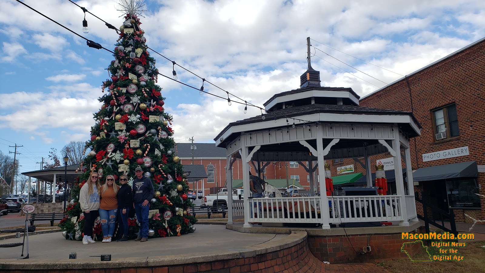
2023 Christmas Tree Timelapse and Photos

Macon Media recorded the efforts of the Town of Franklin Public Works - Streets Department and April's Flowers on Main in constructing and decorating the town Christmas tree from November 13th to the 16th and has compressed all that activity down to a short timelapse. 

2023 Christmas Tree Timelapse (Franklin, NC) | Macon Media


 There are also some photos taken during the decorating, including visits by Santa and Bob Scott to observe the process. Macon Media appreciates the forebearance of all those involved in putting up with me (Bobby) for those four days.
DAY SPONSOR

Young Tree Service is sponsoring Macon Media for today.

They provide complete tree care, are licensed and insured. Specializing in low ground impact. Danger tree removal. Crane Service, Pruning, Views, 24 hr emergency service. Call 828-421-0967 for more information.


Photos


Thursday, January 3, 2019

Daily Weather Briefing for Thursday, January 3, 2019


Christmas Tree Teardown

A work crew from the Town of Franklin tore down the town Christmas Tree and stored it away until the next Christmas season. Here is a brief time lapse of them in action.


Outlook

A series of wet low-pressure systems will move through the southeast through the end of the work week into the start of the weekend providing the potential for another heavy rain event. Expect dry weather for the end of the weekend and to start next week.


THREE DAY GFS FORECAST
This animated image shows a forecast of precipitation, air pressure and thickness level (cold-air damming) for three days in six-hour increments.
Green, Yellow, and Red indicate rain. Orange and Purple Indicate Freezing Rain or other freezing precipitation. Blue indicates snow.


WEATHER SPONSOR


Adams Products, a Division of Oldcastle is underwriting the daily weather briefing & public safety updates for the month.

Open 7:30 AM to 4:00 PM, M-F, located at 895 Hickory Knoll Road, Franklin, NC. Visit our Facebook page at:
https://www.facebook.com/Adams.Oldcastle.Franklin.NC/

All your masonry needs are available. Our phone number is 828.524.8545, the public is welcome, we’ll help you with your with your next project.


Weather Hazards

Areas of dense fog is expected this morning. Fog could become quite dense. Please turn on your headlights while on the roadways so other motorists can see you.

Rain will redevelop late today in response to low pressure moving up from the Gulf Coast. Another period of moderate to heavy rainfall is expected on Friday. With soils still soggy in many areas from the recent rainfall, these upcoming rain event may result in more flooding late this week. Flooding is especially likely along rivers that remain at elevated stages.


WEATHER FORECAST MAPS

Forecast maps for 7 am, 1 pm, and 7 pm.
[click on any image in this article to enlarge]


FRANKLIN AREA FORECAST

Today

Rain likely, mainly before noon. Areas of fog before 11am. Otherwise, cloudy, with a high near 55. Light winds out of the northwest. Chance of precipitation is 60%. New precipitation amounts of less than a tenth of an inch possible.

Tonight

Rain likely, mainly between 2am and 4am, then showers after 4am. Patchy fog after 11pm. Low around 45. Calm winds. Chance of precipitation is 80%. New precipitation amounts between a tenth and quarter of an inch possible.

Friday

Showers. The rain could be heavy at times. Areas of fog before 7am. High near 55. Winds out of the southeast 3 to 7 mph. Chance of precipitation is 90%. New precipitation amounts between three quarters and one inch possible.

Friday Night

Showers likely, mainly before 8pm. Mostly cloudy, with lows in the upper 30s. Winds out of the southwest 5 to 10 mph becoming west northwest after midnight. Chance of precipitation is 60%.

Saturday

Mostly sunny, with a high near 55.

Saturday Night

Mostly clear, with a low around 35.


OTTO AREA FORECAST

Today

Rain likely, mainly before noon. Areas of fog before 11am. Otherwise, cloudy, with a high near 55. Winds out of the northwest around 5 mph becoming calm in the morning. Chance of precipitation is 60%. New precipitation amounts of less than a tenth of an inch possible.

Tonight

Rain likely, mainly between 2am and 4am, then showers after 4am. Patchy fog after 11pm. Low around 45. Light winds of the southeast. Chance of precipitation is 80%. New precipitation amounts between a quarter and half of an inch possible.

Friday

Showers. The rain could be heavy at times. Areas of fog before 7am. High near the lower 50s. Winds out of the southeast 5 to 10 mph. Chance of precipitation is 90%. New precipitation amounts between 1 and 2 inches possible.

Friday Night

Showers likely, mainly before 8pm. Mostly cloudy, with lows in the upper 30s. Winds out of the southwest 5 to 10 mph becoming west northwest after midnight. Chance of precipitation is 60%.

Saturday

Mostly sunny, with a high near 55.

Saturday Night

Mostly clear, with lows in the upper 30s.


HIGHLANDS PLATEAU FORECAST

Today

Rain likely, mainly before noon. Areas of fog before noon. Otherwise, cloudy, with a high near 50. Winds out of the northwest 5 to 10 mph. Chance of precipitation is 60%. New precipitation amounts between a tenth and quarter of an inch possible.

Tonight

Rain likely, mainly between 2am and 3am, then showers after 3am. Areas of fog after 11pm. Low around 45. Calm winds rising to come out of the southeast around 5 mph after midnight. Chance of precipitation is 80%. New precipitation amounts between a quarter and half of an inch possible.

Friday

Showers before 7am, then rain between 7am and 8am, then showers after 8am. The rain could be heavy at times. High near 50. Winds out of the southeast 5 to 10 mph. Chance of precipitation is 90%. New precipitation amounts between 1 and 2 inches possible.

Friday Night

Showers likely, mainly before 8pm. Mostly cloudy, with a low around 35. Winds out of the southwest 10 to 15 mph shifting to come out of the northwest after midnight. Winds could gust as high as 25 mph. Chance of precipitation is 60%.

Saturday

Mostly sunny, with a high near 50.

Saturday Night

Mostly clear, with a low near the upper 30s.


NANTAHALA AREA FORECAST

Today

Rain likely, mainly before noon. Patchy fog before noon. Otherwise, cloudy, with a high near 50. Winds out of the northwest 3 to 5 mph. Chance of precipitation is 60%. New precipitation amounts of less than a tenth of an inch possible.

Tonight

Rain likely, mainly between 2am and 4am, then showers after 4am. Patchy fog after midnight. Low around 45. Calm winds early rising to come out of the southeast around 5 mph after midnight. Chance of precipitation is 80%. New precipitation amounts between a quarter and half of an inch possible.

Friday

Showers. The rain could be heavy at times. Areas of fog before 7am. Highs in the lower 50s. Winds out of the southeast 5 to 10 mph, with gusts as high as 25 mph. Chance of precipitation is 90%. New precipitation amounts between three quarters and one inch possible.

Friday Night

Showers likely, mainly before 10pm. Mostly cloudy, with a low around 35. Winds out of the southwest 5 to 10 mph becoming west northwest after midnight. Winds could gust as high as 20 mph. Chance of precipitation is 60%.

Saturday

Mostly sunny, with a high near 50.

Saturday Night

Mostly clear, with a low around 35.


Macon County Almanac for January 3, 2019

Highest Temperature 69°F in Franklin in 2004
Lowest Temperature -9°F in Highlands in 1979
Greatest Rainfall 2.53 inches at the Coweeta Experimental Station in 1944
Greatest Snowfall 5.5 inches in Highlands in 1914


CROWDFUNDING OR DAY SPONSORSHIP OPPORTUNITIES


If you receive value from what Macon Media provides to the community, please consider becoming a supporter and contribute at least a dollar a month. Those who support Macon Media with at least a dollar a month receive early access to video of some events and meetings before they are made public on the website. Videos and news involving public safety are not subject to early access.

Patreon Subscriber History May 2014 to Present


Become a Patron!

If you have a business or event you are interested in sponsorship opportunities or underwriting coverage, send an email to editor@MaconMedia.com for more information. Serious inquiries only.

Thank You to the people who have been sending in donations and those businesses who are underwriting coverage of news and events. You have kept Macon Media online.


Published at 3:48 am on January 3, 2019


Friday, February 23, 2018

Video Update on the Construction at the old Town Bridge


Construction on the bridge to replace the old town bridge is not entering a phase where daily progress will be easier to see as the actual bridge itself is being built across the Little Tennessee River. The target date for completion is still July 15, 2018. Some photos and a couple of videos of the construction that took place on Thursday, February 22, 2018 is posted below.


Time Lapse of Concrete Girder Installation


Detail of a Concrete Girder being installed


Photos


CROWD FUNDING OR DAY SPONSORSHIP OPPORTUNITIES

If you receive value from what Macon Media provides to the community, please consider becoming a supporter and contribute at least a dollar a month.

If you have a business or event you are interested in sponsorship opportunities or underwriting coverage, send an email to editor@MaconMedia.com for more information.
Serious inquiries only. Macon Media rewards early sponsors/underwriters with lifetime guaranteed low rates while newer sponsors/underwriters pay higher rates based on the date they first support Macon Media.

Thank You to the people who have been sending in donations and those businesses who are underwriting coverage of news and events. You have kept Macon Media online.

You can find out more information on how to do that and some of what I plan to accomplish if I reach certain levels of funding at https://www.patreon.com/MaconMedia

Published at 3:40 pm on February 23, 2018


Tuesday, January 16, 2018

Transformer Swap Timelapse


Here is a time-lapse of the transformer swap on Phillips Street this afternoon.


DAY SPONSOR


Carrion Tree Service is underwriting the daily weather briefing and public safety updates for today. they are a fully licensed and insured tree service, specializing in dangerous tree removal, view clearing, pruning, and crane services with a 24 Hour emergency response.

Their phone number is 371-4718. They are located at 120 Depot Street.

They can handle all your tree removal needs in good or bad weather.


time posted 3:38 pm on 01-16-2018


Friday, December 16, 2016

Morning Time Lapse for December 16, 2016


The evolution of colors this morning was spectacular!

Here is a time lapse taken from the Wal-Mart parking lot this morning of the sky before sunrise this morning. You can also see photos taken by other people that were posted to the Macon Media Weather Page. [LINK]


Saturday, October 29, 2016

USFS Release: Nantahala National Forest Wildfire Summary

Jones Gap Fire Photo by Bobby Coggins

Here is a press release from the US Forest Service on the fires that have started over the last week in the area. Photos and video are by Macon Media.


National Forests in North Carolina
160A Zillicoa St.
Asheville, N.C. 28801 
PIO - Deanna Younger


FRANKLIN, NC, October 29, 2016

Jones Gap Fire:  Reported this morning near Bartram Trail, located northwest of Highlands.  Initial attack crews are on the scene.  The Cliffside Day Use Area between Highlands and Franklin is closed today to allow helicopters to safely dip water from Cliffside Lake to fight the fire. Bartram Trail is also closed from Hickory Knoll Road to State Highway 106 due to fire activity.  Fire size unknown at this time.
                         
Moses Creek Fire: Reported Friday afternoon, October 28, on Sheep Mountain northeast of Cullowhee.  Initial attack using helicopter water drops assisted in reducing fire intensity while dozer containment lines were constructed.  The fire area is roughly estimated at 30+ acres in steep, rough, forested terrain.  Crews are on scene today securing fire lines, extinguishing hot spots, addressing hazard trees and monitoring fire weather conditions.  No structures threatened.
Grape Cove Fire: Started October 26, near Grape Cove Branch located north of Rufus Morgan Falls, west of Franklin - The Boardtree Road remains temporarily closed while fire crews conduct burnout operations today south of Wayah Road.  During burnout operations, firefighters will be putting fire on the ground near containment lines and burning toward the main fire area.   This operation uses low impact fire to create a black area between containment lines and active fire, strengthening fire containment lines.  Smoke may be more visible.  Fire size is about 11 acres.  No structures threatened.
Boteler Peak Fire: Reported October 25, on Boteler Peak near old highway 64 east of Murphy.  Fire size is estimated at 2 acres.  Burning in steep, rough, remote terrain.  Air attack may be on the scene today.  No structures in immediate vicinity of the fire. 
Dicks Creek Fire: Started October 23, northwest of Sylva - Patrol and monitoring continues around containment lines.  Fire activity limited to smoldering large trees well within the interior of the 374-acre fire area.  No structure damage.
HIGH Fire Danger today!
NO Campfires allowed except in developed campgrounds where fees are charged.

Wednesday, July 6, 2016

Storm Brings Wind, Lightning and Power Outages to Macon County

Thunderstorm moves through Macon County


A line of thunderstorms moved through Macon County this evening shortly before dark. They were accompanied by lighting and a gust front that knocked out electrical service to over 200 Duke Energy customers. Power is expected to be restored by 12:30 am.

Here is more information, courtesy of Duke Energy on the outage locations and expected times of restoration as of 9:30 pm:


This image shows the outages in the Timberland Trail area (purple) and Arnold Branch (green) areas.

Timberland Trail Outage - 20 Duke Energy Customers
Time Reported - 8:17 pm
Restoration estimate - 12:30 am

Arnold Branch Outage - 139 Duke Energy Customers
Time Reported - 8:15 pm
Restoration estimate - 11:30 pm


This image shows the outage in the Lakey Creek area.

Lakey Creek Outage - 60
Time Reported - 7:47 pm
Restoration estimate - 11:00 pm

Outages in the western North Carolina counties served by Duke Energy:

Cherokee - 12 customers in 5 locations
Graham - 28 customers in 4 locations
Swain - 629 customers in 6 locations
Macon - 266 customers in 12 locations
Jackson - 47 customers in 9 locations
Haywood - 5 customers in 3 locations
Buncombe - 2,160 customers in 91 locations
Henderson - 1,435 customers in 34 locations


More rain is forecast for this evening, but no more severe weather is expected overnight at this time.


**11:27 pm** Here is a time lapse of the arrival of the storms as seen from the Holly Springs Shopping Center:


The jitter in the first clip was caused by the wind. I had to anchor the tripod to keep it from being blown over. The wind also blew my hat off my head and my magnetically mounted scanner antenna off the van.


CROWD FUNDING OR DAY SPONSORSHIP OPPORTUNITIES

If you receive value from what Macon Media provides to the community, please consider becoming a supporter and contribute at least a dollar a month.

If you have a business or event you are interested in sponsorship opportunities or underwriting coverage, send an email to editor@MaconMedia.com for more information. Serious inquiries only.

Thank You to the people who have been sending in donations and those businesses who are underwriting coverage of news and events. You have kept Macon Media online.

You can find out more information on how to do that and some of what I plan to accomplish if I reach certain levels of funding at >> https://www.patreon.com/MaconMedia


Wednesday, September 11, 2013

Time Lapse: NCDOT Installs Cross Walk Light in Franklin, NC

NCDOT Installs Cross Walk Light
Photo ©2013 by Bobby Coggins


A time lapse of a North Carolina Department of Transportation work crew installing a cross walk light to replace on that had been destroyed in an automobile accident the day before (Tuesday the 10th of September) at East Palmer Street and Phillips Street in Franklin, NC.

Thursday, October 18, 2012

ISS Startrails - TRONized by Christoph Malin

Here is a creative video using photos taken from the International Space Station in style of the old Science Fiction movie Tron. A movie, believe it or not, that I have never seen.

ISS Startrails - TRONized from Christoph Malin on Vimeo.

Do you remember 1982's "TRON" movie? The plot: A computer programmer (epic: Jeff Bridges) is digitized inside the software world of a mainframe computer, where he interacts with various programs in his attempt to get back out. Including light cycle races and strange solar wind ships...

Back in the real word the ISS is in a way one of these solar ships, constantly rotating around us. A tiny white spot, as it can be seen racing over the sky from time to time, when illuminated by the sunset (and sunrise ;).

This Video was achived by "stacking" image sequences provided by NASA from the Crew at International Space Station, see also http://www.fragileoasis.org/blog/2012/3/on-the-trails-of-stars/. These "stacks" create the Star Trails, but furthermore make interesting patterns visible. For example lightning corridors within clouds, but they also show occasional satellite tracks (or Iridium Flashes) as well as meteors - patterns that interrupt the main Star Trails, and thus are immediately visible.

The many oversaturated hot pixels in some of the scenes are the inevitable result of high ISO settings the Nikon D3s in ISS-use are pushed to for keeping exposure times short (owed to the dramatic speed the ISS travels). As there are no dark frames or RAW data currently available, hot pixels are not easy to remove.

After the initial stacking, all images have been sequenced with Apple Motion and the Video cut and edited with Final Cut Pro X. Stacked with the StarStaX app, get it here: markus-enzweiler.de/software/software.html

All sequences and images courtesy "The Gateway to Astronaut Photography of Earth", Image Science & Analysis Laboratory, NASA Johnson Space Center, eol.jsc.nasa.gov/Videos/CrewEarthObservationsVideos/

Closing sequence © Christoph Malin / ESO.org / filmed at Cerro Paranal.

Thanks a lot to my favourite bad Astronomer, Phil at BadAstronomy for first posting the film (http://blogs.discovermagazine.com/badastronomy/2012/10/16/my-god-its-full-of-star-trails/) and many many thanks to Vimeo for the Staff Pick!

Great minimal soundtrack "Eileen" by Lee Rosevere (http://members.shaw.ca/happypuppyrecords/index.html), and a short clip of "Window #3" by Two Bicycles (http://freemusicarchive.org/music/Two_Bicycles/Beko_Crash_Symbols_1/07_Window_3). VIMEO MUSIC STORE ROCKS!

A truckload of thanks go out to NASA astronaut Don Pettit (http://www.petapixel.com/2012/06/25/astronaut-don-pettit-floating-with-his-huge-camera-collection-on-the-iss/) and his colleagues for taking these images, and making films like this one reality!

Finally, please also be aware of Light Pollution (http://www.plightwithlight.org/index.php?id=49&L=1) one can see in many of these scenes! In the US join http://www.darksky.org/ for preserving the night skies for our children!!

Always believe in your dreams and make it possible!

All the best,
Christoph Malin
christophmalin.com

PS: At about 1:42 you see Comet "Lovejoy" rising...

facebook.com/christoph.malin
twitter.com/#!/christophmalin
twanight.org/cmalin


Wednesday, April 25, 2012

Contrails and Cirrus

Contrails and Cirrus 
Photo by Bobby Coggins

I love watching cirrus and contrails march across the sky.

Below is a time lapse video I shot in February 2010 of contrails marching across the sky:


Bookmark and Share

Wednesday, October 5, 2011

A Bridge Too Far


I have a weakness for time lapses. Here is a good one from the United Kingdom.


From the video description:


A1(M) overnight bridge demolition between Darlington & Dishforth.


As part of the M1 motorway upgrade scheme the Highways Agency (Yorkshire and Humber) closed the A1, North Yorkshire between Junction 60 (near Darlington) and Junction 49 (Dishforth). Saturday 9 April - Sunday 10 April 2011


--------------------


Production Notes:
Timeplase with the Canon 5Dmk2. 18+ hours 4,000 images.
Jpegs assembled in Apple Quicktime. Output in Prores at native 5616x3744 & 1920x1080, cut in FCP. The 5616x3744 layer was used for panned close up shots. The 1920x1080 was used as a base layer.


Graded with three way colour correction in FCP. Output and rendered in Apple Compressor adding additional blanket colour correction and sharpness.


Lens became fogged at around 3:30am. Very cold from 2am-6am drained batteries fast.


Thanks also to Luke Miller.


hutch.ws


Soundtrack: Angèle Dubeau & Le Pietà / |. Relaxed Groove

Bookmark and Share