Notice

I am working on the template of this blog today in order to chase down some problems that have developed with my template and widgets.

Macon County Commissioners

Coverage of the meetings of the Macon County Board of County Commissioners.

Franklin Town Board of Aldermen

Coverage of the meetings of the Franklin Town Board of Aldermen.

Macon County School Board

Coverage of the meetings of the Macon County School Board.

Photoblog

Photos from my photoblog.

nullspace for future use

nullspace for future use

About

Showing posts with label July 2018 Weather. Show all posts

Monday, July 30, 2018

Daily Weather Briefing for Monday, July 30, 2018


LEGISLATIVE CALENDAR

The North Carolina General Assembly will be meeting today and is expected to override the Governor's veto of House Bill 3 and Senate Bill 3. More information is posted on the website. [LINK]

Mission Health Live Facebook Event

Mission Health will be streaming a live Facebook stream tonight at www.facebook.com/MissionHealthNC

The press release is posted below.

What Joining HCA Means for Our Rural Communities

Join a panel of regional healthcare experts Monday, August 6th at 6:30 pm, as they explore what Mission’s intent to join HCA Healthcare is likely to mean for rural western North Carolina communities. The event will be broadcast live on Facebook and will include opportunities to have your questions answered by the evening’s panelists as well as resources to find more information.

Beginning at 6:30 pm, you will have the opportunity to hear from leaders and community board members from regional hospitals who traveled to central Tennessee to learn more about HCA’s commitment to rural healthcare.

Panelists you will hear from include:

• Kathy Guyette, MSN, RN, NEA-BC, Senior Vice President, Patient Care Services & President Regional Member Hospitals, Mission Health
• Rebecca W. Carter, MSN, RN, FACHE, President & Chief Nursing Officer, Blue Ridge Regional Hospital
• Brian Barrow, MD, Chief of Staff, Transylvania Regional Hospital

LOCAL WEATHER OUTLOOK

A stationary front will remain over our region through the today and then move north as a warm front early in the work week. With low pressure developing to the west, strong and moist flow from the Gulf of Mexico will bring abundant moisture back to the region through the end of the week.


DAY SPONSOR

Carrion Tree Service is underwriting the daily weather briefing and public safety updates for today. they are

a fully licensed and insured tree service, specializing in dangerous tree removal, view clearing, pruning, and crane services with a 24 Hour emergency response.

Their phone number is 371-4718. They are located at 120 Depot Street.

They can handle all your tree removal needs in good or bad weather.


WEATHER SPONSOR


Adams Products, a Division of Oldcastle is underwriting the daily weather briefing & public safety updates for the month.

Open 7:30 AM to 4:00 PM, M-F, located at 895 Hickory Knoll Road, Franklin, NC. Visit our Facebook page at:
https://www.facebook.com/Adams.Oldcastle.Franklin.NC/

All your masonry needs are available. Our phone number is 828.524.8545, the public is welcome, we’ll help you with your with your next project.

Weather Almanac for July 30th (1872-2016)
Record weather events for this date in Macon County

Highest Temperature 94°F in Franklin in 1952
Lowest Temperature 44°F in Highlands in 1911
Greatest Rainfall 3.00 inches in Franklin in 1878

Record Weather Events for July (1872-2017)

Highest Temperature 101°F in Franklin on July 29, 1952
Lowest Temperature 34°F in Highlands on July 2, 1911
Greatest Rainfall 21.15 inches in Highlands on July 29, 1879


WEATHER FORECAST MAPS

Forecast maps for 8 am, 2 pm, and 8 pm. 

[click on any image in this article to enlarge]
(These images replace the three-day forecast maps)


THREE DAY OUTLOOK


--------------------------------------

FRANKLIN AREA

TODAY

Scattered showers and thunderstorms. Patchy fog between 7am and 10am. Otherwise, partly sunny, with a high near 83. Calm wind becoming south around 5 mph in the afternoon. Chance of precipitation is 40%. New rainfall amounts of less than a tenth of an inch, except higher amounts possible in thunderstorms.

TONIGHT

Showers likely and possibly a thunderstorm. Otherwise, mostly cloudy, with a low around 66. South wind around 5 mph becoming light and variable. Chance of precipitation is 60%. New rainfall amounts between a tenth and quarter of an inch, except higher amounts possible in thunderstorms.

TUESDAY

Showers and thunderstorms. High near 81. South wind around 6 mph. Chance of precipitation is 80%. New rainfall amounts between a quarter and half of an inch possible.

TUESDAY NIGHT

Showers and thunderstorms before 9pm, then showers and possibly a thunderstorm after 9pm. Low around 65. Light and variable wind. Chance of precipitation is 80%.

WEDNESDAY

Showers likely and possibly a thunderstorm before 11am, then showers and thunderstorms likely after 11am. Cloudy, with a high near 78. Chance of precipitation is 70%.

WEDNESDAY NIGHT

Showers and thunderstorms before 1am, then showers are likely. Low around 63. Chance of precipitation is 80%.


--------------------------------------

OTTO AREA

TODAY

A 40 percent chance of showers and thunderstorms. Patchy fog before 9am. Otherwise, partly sunny, with a high near 81. Calm wind becoming south around 6 mph in the afternoon. New rainfall amounts of less than a tenth of an inch, except higher amounts possible in thunderstorms.

TONIGHT

Showers and thunderstorms likely. Patchy fog between 10pm and 2am. Otherwise, mostly cloudy, with a low around 65. Light and variable wind becoming east around 5 mph in the evening. Chance of precipitation is 60%. New rainfall amounts between a tenth and quarter of an inch, except higher amounts possible in thunderstorms.

TUESDAY

Showers and thunderstorms. High near 78. South wind 3 to 6 mph. Chance of precipitation is 80%. New rainfall amounts between a half and three-quarters of an inch possible.

TUESDAY NIGHT

Showers and thunderstorms before 9pm, then showers and possibly a thunderstorm after 9pm. Low around 65. Light southwest wind. Chance of precipitation is 80%.

WEDNESDAY

Showers likely and possibly a thunderstorm. High near 75. Chance of precipitation is 80%.

WEDNESDAY NIGHT

Showers and thunderstorms. Low around 63. Chance of precipitation is 80%.


--------------------------------------

HIGHLANDS AREA

TODAY

A 40 percent chance of showers and thunderstorms. Widespread fog, mainly before 8am. Otherwise, mostly cloudy, with a high near 73. South wind 3 to 7 mph. New rainfall amounts between a tenth and quarter of an inch, except higher amounts possible in thunderstorms.

TONIGHT

Showers and thunderstorms likely. Patchy fog between midnight and 2am. Otherwise, mostly cloudy, with a low around 61. South wind 6 to 9 mph. Chance of precipitation is 60%. New rainfall amounts between a quarter and half of an inch possible.

TUESDAY

Showers and thunderstorms. High near 71. South southwest wind 7 to 9 mph. Chance of precipitation is 80%. New rainfall amounts between a half and three-quarters of an inch possible.

TUESDAY NIGHT

Showers and thunderstorms before 9pm, then showers and possibly a thunderstorm after 9pm. Low around 60. Southwest wind around 8 mph. Chance of precipitation is 80%.

WEDNESDAY

Showers likely and possibly a thunderstorm. High near 70. Chance of precipitation is 80%.

WEDNESDAY NIGHT

Showers and thunderstorms. Low around 60. Chance of precipitation is 80%.

--------------------------------------

NANTAHALA AREA

TODAY

A 50 percent chance of showers and thunderstorms, mainly after 8am. Patchy fog before 9am. Otherwise, partly sunny, with a high near 78. Southwest wind 3 to 6 mph. New rainfall amounts of less than a tenth of an inch, except higher amounts possible in thunderstorms.

TONIGHT

Showers and thunderstorms likely. Patchy fog between midnight and 2am. Otherwise, mostly cloudy, with a low around 62. South wind 5 to 7 mph. Chance of precipitation is 60%. New rainfall amounts between a tenth and quarter of an inch, except higher amounts possible in thunderstorms.

TUESDAY

Showers likely and possibly a thunderstorm, then showers and thunderstorms after 10am. Some of the storms could produce heavy rainfall. High near 77. South southwest wind 5 to 7 mph. Chance of precipitation is 80%. New rainfall amounts between a half and three-quarters of an inch possible.

TUESDAY NIGHT

Showers and thunderstorms before 9pm, then showers and possibly a thunderstorm after 9pm. Some of the storms could produce heavy rainfall. Low around 61. South wind 3 to 5 mph. Chance of precipitation is 80%.

WEDNESDAY

Showers likely and possibly a thunderstorm before 11am, then showers and thunderstorms likely after 11am. Cloudy, with a high near 74. Chance of precipitation is 70%.

WEDNESDAY NIGHT

Showers and thunderstorms likely. Mostly cloudy, with a low around 60. Chance of precipitation is 70%.

--------------------------------------


GOES-16 GeoColor - True Color daytime, multispectral IR
11:12 pm last night to 2:07 am this morning


HAZARDS

Hazardous weather is not expected today.

The National Weather Service is forecasting heavy rain Tuesday and Wednesday. The NWS Hazardous Weather Outlook is posted below:

..TUESDAY...Heavy rain possible. An unsettled pattern will set up over the region, resulting in periods of heavy rainfall.
..WEDNESDAY...Heavy rain possible.

Macon Media maintains a Severe Weather Preparedness Page at http://thunderpigblog.blogspot.com/p/breaking-news-hub.html for those who are interested.

As always, you can check to see what advisories, watches, and warnings are in effect for Macon County by visiting http://is.gd/MACONWARN


GOES 16 - Band 15 - 12.3 µm - Dirty Longwave Window - IR (Precipitation)
2:12 am this morning

TROPICAL OUTLOOK


Tropical Weather Outlook
NWS National Hurricane Center Miami FL
200 AM EDT Mon Jul 30 2018

For the North Atlantic...Caribbean Sea and the Gulf of Mexico:

Tropical cyclone formation is not expected during the next 5 days.


MACON CALENDAR

If you have an event you wish to be added to this calendar, please send the information, along with a flyer in pdf format or a high-quality photo, to editor@maconmedia.com. If you want text published, please include a paragraph with your photo, flyer or graphics. Please include date(s) and time(s).
There is no charge for civic, educational or nonprofit groups, except for groups or events that receive funding from the TDA, TDC, and EDC, where full rates apply.

Organizers of political events must make themselves available for a video interview at least 7 days before a political event they wish Macon Media to promote. Two weeks is the preferred time frame to maximize awareness.


Mission Health Live Facebook Event

Mission Health will be streaming a live Facebook stream tonight at www.facebook.com/MissionHealthNC

The press release is posted below.

What Joining HCA Means for Our Rural Communities

Join a panel of regional healthcare experts Monday, August 6th at 6:30 pm, as they explore what Mission’s intent to join HCA Healthcare is likely to mean for rural western North Carolina communities. The event will be broadcast live on Facebook and will include opportunities to have your questions answered by the evening’s panelists as well as resources to find more information.

Beginning at 6:30 pm, you will have the opportunity to hear from leaders and community board members from regional hospitals who traveled to central Tennessee to learn more about HCA’s commitment to rural healthcare.

Panelists you will hear from include:

• Kathy Guyette, MSN, RN, NEA-BC, Senior Vice President, Patient Care Services & President Regional Member Hospitals, Mission Health
• Rebecca W. Carter, MSN, RN, FACHE, President & Chief Nursing Officer, Blue Ridge Regional Hospital
• Brian Barrow, MD, Chief of Staff, Transylvania Regional Hospital


Suminski Family Books Summer Film Fest for Families

All ticket sales sold by FROG volunteers benefit:

FRIENDS OF THE GREENWAY, INC.

Location: Smoky Mountain Center for the Performing Arts
Start time for each movie: 7:00 PM
Save When You Pre-Buy Your Tickets!

Single Ticket $5 for each movie (pre & at the door)
Season Pass $15 1 ticket to each movie Family of 4 Season Passes $50 4 tickets to each movie

Movies and Dates:

Paddington 2 on July 12, 2018
Hidden Figures on July 19, 2018
Peter Rabbit on August 19, 2018
Wonder on August 26, 2018 (benefits Friends of the Greenway)

Purchase at FROG Quarters, 573 E. Main (next to new bridge) Hours: Wed-Fri, 9 AM-2 PM

There are 3 other non-profits involved: Folk Heritage Association of Macon County NC, Grandpa’s Woodshed Project, Women’s History Trail, and Read2Me. The FROG-specific specific movie is Wonder, but our members can pre-sell tickets to all movies.

Franklin Health & Fitness 30th Anniversary Celebration [LINK]
http://thunderpigblog.blogspot.com/2018/07/franklin-health-fitness-announces-their.html

Uptown Gallery classes
(These are on-going classes – repeat weekly)

Free classes and open studio times are being offered at The Uptown Gallery in Franklin. Join others at a painting open studio session every Tuesday from 6:30 pm – 9:00 pm or on Thursday from 11:00 am – 3:00 pm.
Bring your own materials and join an on-going drawing course led by gallery artists on Fridays, from 11am – 2 pm. For information on days open, hours and additional art classes and workshops, contact the gallery on 30 East Main Street at (828) 349 – 4607.

National Alliance on Mental Illness
Appalachian South


Meets each Thursday at 7pm
The First Methodist Church Outreach Center
at the intersection of Harrison Ave. and West Main Street
(directly across from Lazy Hiker Brewery)

Come join our weekly support group for anyone suffering from mental illness and their family or friends. This includes Depression, Bipolar,8chizophrenia, PTSD, Substance Abuse, Etc.

Here you will find:
— others living with mental health challenges YOU ARE NOT ALONE
- learn coping skills and ?find hope in shared experience
- help learning how to break down stigma and guilt surrounding mental health
- how to live life with the expectation of a better a better future

Kay (706)970-9987 Denise (828)347-5000)

SYRINGE EXCHANGE PROGRAM

On January 1, 2017, the Syringe Exchange Program of Franklin began operating a comprehensive harm reduction program to address the opioid epidemic that is impacting western NC. Opioid overdose reversal kits including naloxone are available free of charge. If you have any questions about our services or if you know someone interested in volunteering, please contact Stephanie Almeida at 828-475-1920.


Sun and Moon

Sun

Begin civil twilight 6:13 a.m.
Sunrise 6:41 a.m.
Sun transit 1:40 p.m.
Sunset 8:38 p.m.
End civil twilight 9:06 p.m.


Moon

Moonrise 9:58 p.m. last night
Moon transit 3:29 a.m.
Moonset 9:06 a.m.
Moonrise 10:31 p.m.


Phase of the Moon on July 30, 2018: Waning Gibbous with 93% of the Moon's visible disk illuminated.
Closest Primary Moon Phase: Full Moon on July 27, 2018 at 4:20 p.m. (local daylight time)


Sky Guides for this week


Sky and Telescope Magazine 
Astronomy Magazine


There will be three solar and two lunar eclipses in 2018. [LINK]

Heavens Above has an Android App that will assist you in observing the sky and even has a satellite tracker that will let you know when the International Space Station and dozens of other satellites are overhead. [LINK]

Stellarium is also an app that will assist you in observing the sky. It is available in both Android [LINK] and iOS versions. [LINK]

CROWDFUNDING OR DAY SPONSORSHIP OPPORTUNITIES


If you receive value from what Macon Media provides to the community, please consider becoming a supporter and contribute at least a dollar a month.


Become a Patron!

If you have a business or event you are interested in sponsorship opportunities or underwriting coverage, send an email to editor@MaconMedia.com for more information. Serious inquiries only. Macon Media rewards early sponsors/underwriters with lifetime guaranteed low rates while newer sponsors/underwriters pay higher rates based on the date they first support Macon Media.

Thank You to the people who have been sending in donations and those businesses who are underwriting coverage of news and events. You have kept Macon Media online.


Published at 2:30 am on July 30, 2018

#WNCscan #MaconWx #MaconSafety


Data and information sources: Sources (except where otherwise credited): heavens-above.com, Ian Webster's Github, National Centers for Environmental Prediction, The National Weather Service, National Oceanic Atmospheric Administration, National Hurricane Center, Penn State University Electronic Wall Map, The State Climate Office of North Carolina, Storm Prediction Center, U.S. Naval Observatory, University of Utah Department of Atmospheric Sciences, and the Weather Prediction Center.

Thursday, July 12, 2018

Daily Weather Briefing for Thursday, July 12, 2018


LOCAL NEWS

Duke LifePoint Holds Community Forum at Town Hall

A community forum was held last night at the town hall to introduce the community to the services offered by Duke LifePoint in Macon County. A video and photos taken at the forum has been posted on MaconMedia.com [LINK]

The Macon County Board of Commissioners met Tuesday night at 6 pm. Video of the meeting, the public agenda, agenda packet, and the proposed 2019 Schedule of Values, Standards, and Rules for Market Value are on the blog. [LINK]

LOCAL OUTLOOK

A weak cold front will move slowly southward across the region today, accompanied by an increase in moisture. High pressure will return Friday through the weekend as the front slowly dissipates to our south. Moisture will return gradually during the early to middle part of next week ahead of a cold front moving southeast through the Ohio Valley.


WEATHER SPONSOR


Adams Products, a Division of Oldcastle is underwriting the daily weather briefing & public safety updates for the month.

Open 7:30 AM to 4:00 PM, M-F, located at 895 Hickory Knoll Road, Franklin, NC. Visit our Facebook page at:
https://www.facebook.com/Adams.Oldcastle.Franklin.NC/

All your masonry needs are available. Our phone number is 828.524.8545, the public is welcome, we’ll help you with your with your next project.

Weather Almanac for July 12th (1872-2016)
Record weather events for this date in Macon County

Highest Temperature 98°F in Highlands in 1930
Lowest Temperature 42°F in Highlands in 1918
Greatest Rainfall 4.55 inches in Highlands in 1948

Record Weather Events for July (1872-2017)

Highest Temperature 101°F in Franklin on July 29, 1952
Lowest Temperature 34°F in Highlands on July 2, 1911
Greatest Rainfall 21.15 inches in Highlands on July 29, 1879


WEATHER FORECAST MAPS

Forecast maps for 8 am, 2 pm, and 8 pm. 

[click on any image in this article to enlarge]
(These images replace the three-day forecast maps)


THREE DAY OUTLOOK


--------------------------------------

FRANKLIN AREA

TODAY

A chance of showers, with thunderstorms and heavy rainfall also possible after 10am. Patchy fog before 9am. Otherwise, cloudy, then gradually becoming mostly sunny, with a high near 84. Light and variable wind. Chance of precipitation is 50%. New rainfall amounts between a quarter and half of an inch possible.

TONIGHT

A 40 percent chance of showers and thunderstorms. Patchy fog after 2am. Otherwise, mostly cloudy, with a low around 66. Calm wind. New rainfall amounts between a tenth and quarter of an inch, except higher amounts possible in thunderstorms.

FRIDAY

A 50 percent chance of showers and thunderstorms. Patchy fog before 8am. Otherwise, partly sunny, with a high near 85. Calm wind becoming south around 5 mph in the afternoon. New rainfall amounts between a tenth and quarter of an inch, except higher amounts possible in thunderstorms.

FRIDAY NIGHT

A chance of showers and thunderstorms. Mostly cloudy, with a low around 66. Calm wind. Chance of precipitation is 30%.

SATURDAY

A slight chance of showers, then a chance of showers and thunderstorms after 11am. Partly sunny, with a high near 85. Chance of precipitation is 40%.

SATURDAY NIGHT

A chance of showers and thunderstorms before 1am, then a chance of rain after 5am. Mostly cloudy, with a low around 65. Chance of precipitation is 40%.


--------------------------------------

OTTO AREA

TODAY

Showers and thunderstorms likely with heavy rain possible. Patchy fog before 9am. Otherwise, mostly cloudy, with a high near 83. Light and variable wind. Chance of precipitation is 60%. New rainfall amounts between a quarter and half of an inch possible.

TONIGHT

A 50 percent chance of showers and thunderstorms. Patchy fog after 2am. Otherwise, mostly cloudy, with a low around 66. Calm wind. New rainfall amounts between a tenth and quarter of an inch, except higher amounts possible in thunderstorms.

FRIDAY

A 50 percent chance of showers and thunderstorms. Patchy fog before 8am. Otherwise, partly sunny, with a high near 84. Calm wind becoming southeast around 5 mph in the afternoon. New rainfall amounts between a tenth and quarter of an inch, except higher amounts possible in thunderstorms.

FRIDAY NIGHT

A chance of showers and thunderstorms. Mostly cloudy, with a low around 66. Calm wind. Chance of precipitation is 40%.

SATURDAY

A slight chance of showers, then a chance of showers and thunderstorms after 11am. Partly sunny, with a high near 84. Chance of precipitation is 40%.

SATURDAY NIGHT

A chance of showers and thunderstorm. Mostly cloudy, with a low around 65. Chance of precipitation is 40%.


--------------------------------------

HIGHLANDS AREA

TODAY

Showers and thunderstorms likely, mainly after 2pm. Patchy fog before 9am. Otherwise, partly sunny, with a high near 74. Calm wind becoming south around 5 mph in the afternoon. Chance of precipitation is 60%. New rainfall amounts between a half and three-quarters of an inch possible.

TONIGHT

Showers and thunderstorms likely, mainly before 7pm. Patchy fog after 2am. Otherwise, mostly cloudy, with a low around 62. Calm wind becoming east southeast around 6 mph after midnight. Chance of precipitation is 60%. New rainfall amounts between a quarter and half of an inch possible.

FRIDAY

A 50 percent chance of showers and thunderstorms. Patchy fog before 8am. Otherwise, partly sunny, with a high near 74. East southeast wind 5 to 7 mph. New rainfall amounts between a quarter and half of an inch possible.

FRIDAY NIGHT

A chance of showers and thunderstorms. Mostly cloudy, with a low around 62. East southeast wind 5 to 7 mph. Chance of precipitation is 40%.

SATURDAY

A chance of showers, with thunderstorms also possible after noon. Partly sunny, with a high near 74. Chance of precipitation is 40%.

SATURDAY NIGHT

A chance of showers and thunderstorms. Mostly cloudy, with a low around 63. Chance of precipitation is 30%.


--------------------------------------

NANTAHALA AREA

TODAY

A 50 percent chance of showers and thunderstorms, mainly after 10am. Patchy fog before 10am. Otherwise, partly sunny, with a high near 78. Calm wind becoming west around 5 mph in the afternoon. New rainfall amounts between a quarter and half of an inch possible.

TONIGHT

A 30 percent chance of showers and thunderstorms, mainly before 4am. Patchy fog before 1am, then patchy fog after 2am. Otherwise, partly cloudy, with a low around 62. Light and variable wind. New rainfall amounts between a tenth and quarter of an inch, except higher amounts possible in thunderstorms.

FRIDAY

A 40 percent chance of showers and thunderstorms, mainly after 10am. Partly sunny, with a high near 77. Calm wind becoming south around 5 mph in the afternoon. New rainfall amounts between a tenth and quarter of an inch, except higher amounts possible in thunderstorms.

FRIDAY NIGHT

A chance of showers and thunderstorms. Mostly cloudy, with a low around 63. Light southeast wind. Chance of precipitation is 30%. New precipitation amounts between a tenth and quarter of an inch, except higher amounts possible in thunderstorms.

SATURDAY

A slight chance of showers, then a chance of showers and thunderstorms after 10am. Partly sunny, with a high near 78. South wind 3 to 5 mph. Chance of precipitation is 30%.

SATURDAY NIGHT

A chance of showers and thunderstorms before 11pm, then a slight chance of showers between 11pm and 5am. Mostly cloudy, with a low around 63. Chance of precipitation is 30%.

--------------------------------------


GOES-16 GeoColor - True Color daytime, multispectral IR
12:47 to 3:47 am this morning


HAZARDS

Heavy rain is possible today. Showers and thunderstorms will develop along a stalled frontal boundary. Copious moisture and slow-moving storms will lead to the threat of heavy rainfall. Localized flooding and standing water may occur where there is poor drainage. If you are out driving when the heavy rainfall is happening, or shortly after, please slow down, use your headlights so other motorists can see you and increase the distance you follow other motorists. Hydroplaning may become an issue.

Macon Media maintains a Severe Weather Preparedness Page at http://thunderpigblog.blogspot.com/p/breaking-news-hub.html for those who are interested.

As always, you can check to see what advisories, watches, and warnings are in effect for Macon County by visiting http://is.gd/MACONWARN


GOES 16 - Band 15 - 12.3 µm - Dirty Longwave Window - IR (Precipitation)
3:57 am this morning

TROPICAL OUTLOOK


Tropical Weather Outlook
NWS National Hurricane Center Miami FL
200 AM EDT Thu Jul 12 2018

For the North Atlantic...Caribbean Sea and the Gulf of Mexico:

The National Hurricane Center is issuing advisories on Hurricane Chris, located about 700 miles southwest of Cape Race, Newfoundland.

1. The remnants of Beryl is producing an area of disorganized showers and thunderstorms extending from the Bahamas northeastward over the western Atlantic for a few hundred miles. There are no signs of a surface circulation, and surfaces pressures are not falling at this time. Little or no development is expected today, but conditions could become a little more favorable later in the week and over the weekend while the disturbance moves slowly northward and northeastward over the western Atlantic.

* Formation chance through 48 hours...low...20 percent.
* Formation chance through 5 days...medium...50 percent.


MACON CALENDAR

If you have an event you wish to be added to this calendar, please send the information, along with a flyer in pdf format or a high-quality photo, to editor@maconmedia.com. If you want text published, please include a paragraph with your photo, flyer or graphics. Please include date(s) and time(s).
There is no charge for civic, educational or nonprofit groups, except for groups or events that receive funding from the TDA, TDC, and EDC, where full rates apply.

Organizers of political events must make themselves available for a video interview at least 7 days before a political event they wish Macon Media to promote. Two weeks is the preferred time frame to maximize awareness.


Community Health Fair at Angel Medical Center

Angel Medical Center will host a community health fair on July 17, from 3 to 5 pm in the hospital cafeteria. Blood pressure checks, glucose checks, fall risk assessments and information on the 20/30 weight-loss plan offered by Franklin Health & Fitness will be provided.

For more information, call 828-349-6639.

Suminski Family Books Summer Film Fest for Families

All ticket sales sold by FROG volunteers benefit:

FRIENDS OF THE GREENWAY, INC.

Location: Smoky Mountain Center for the Performing Arts
Start time for each movie: 7:00 PM
Save When You Pre-Buy Your Tickets!

Single Ticket $5 for each movie (pre & at the door)
Season Pass $15 1 ticket to each movie Family of 4 Season Passes $50 4 tickets to each movie

Movies and Dates:

Paddington 2 on July 12, 2018
Hidden Figures on July 19, 2018
Peter Rabbit on August 19, 2018
Wonder on August 26, 2018 (benefits Friends of the Greenway)

Purchase at FROG Quarters, 573 E. Main (next to new bridge) Hours: Wed-Fri, 9 AM-2 PM

There are 3 other non-profits involved: Folk Heritage Association of Macon County NC, Grandpa’s Woodshed Project, Women’s History Trail, and Read2Me. The FROG-specific specific movie is Wonder, but our members can pre-sell tickets to all movies.


Uptown Gallery classes
(These are on-going classes – repeat weekly)

Free classes and open studio times are being offered at The Uptown Gallery in Franklin. Join others at a painting open studio session every Tuesday from 6:30 pm – 9:00 pm or on Thursday from 11:00 am – 3:00 pm.
Bring your own materials and join an on-going drawing course led by gallery artists on Fridays, from 11am – 2 pm. For information on days open, hours and additional art classes and workshops, contact the gallery on 30 East Main Street at (828) 349 – 4607.

National Alliance on Mental Illness
Appalachian South


Meets each Thursday at 7pm
The First Methodist Church Outreach Center
at the intersection of Harrison Ave. and West Main Street
(directly across from Lazy Hiker Brewery)

Come join our weekly support group for anyone suffering from mental illness and their family or friends. This includes Depression, Bipolar,8chizophrenia, PTSD, Substance Abuse, Etc.

Here you will find:
— others living with mental health challenges YOU ARE NOT ALONE
- learn coping skills and ?find hope in shared experience
- help learning how to break down stigma and guilt surrounding mental health
- how to live life with the expectation of a better a better future

Kay (706)970-9987 Denise (828)347-5000)

SYRINGE EXCHANGE PROGRAM

On January 1, 2017, the Syringe Exchange Program of Franklin began operating a comprehensive harm reduction program to address the opioid epidemic that is impacting western NC. Opioid overdose reversal kits including naloxone are available free of charge. If you have any questions about our services or if you know someone interested in volunteering, please contact Stephanie Almeida at 828-475-1920.


Sun and Moon

Sun

Begin civil twilight 5:59 a.m.
Sunrise 6:29 a.m.
Sun transit 1:39 p.m.
Sunset 8:49 p.m.
End civil twilight 9:19 p.m.


Moon

Moonrise 5:54 a.m.
Moon transit 1:14 p.m.
Moonset 8:33 p.m.


Phase of the Moon on July 12, 2018: New Moon at 10:48 p.m. (local daylight time)

Sky Guides for this week


Sky and Telescope Magazine 
Astronomy Magazine


There will be three solar and two lunar eclipses in 2018. [LINK]

Heavens Above has an Android App that will assist you in observing the sky and even has a satellite tracker that will let you know when the International Space Station and dozens of other satellites are overhead. [LINK]

Stellarium is also an app that will assist you in observing the sky. It is available in both Android [LINK] and iOS versions. [LINK]

CROWDFUNDING OR DAY SPONSORSHIP OPPORTUNITIES


If you receive value from what Macon Media provides to the community, please consider becoming a supporter and contribute at least a dollar a month.


Become a Patron!

If you have a business or event you are interested in sponsorship opportunities or underwriting coverage, send an email to editor@MaconMedia.com for more information. Serious inquiries only. Macon Media rewards early sponsors/underwriters with lifetime guaranteed low rates while newer sponsors/underwriters pay higher rates based on the date they first support Macon Media.

Thank You to the people who have been sending in donations and those businesses who are underwriting coverage of news and events. You have kept Macon Media online.

Learn more about becoming a patron of Macon Media at https://www.patreon.com/MaconMedia

Published at 4:20 am on July 12, 2018 

Author Bobby Coggins
Edited at 4:57 am to add a link to the Duke LifePoint Forum

#WNCscan #MaconWx #MaconSafety


Data and information sources: Sources (except where otherwise credited): heavens-above.com, Ian Webster's Github, National Centers for Environmental Prediction, The National Weather Service, National Oceanic Atmospheric Administration, National Hurricane Center, Penn State University Electronic Wall Map, The State Climate Office of North Carolina, Storm Prediction Center, U.S. Naval Observatory, University of Utah Department of Atmospheric Sciences, and the Weather Prediction Center.

Wednesday, July 11, 2018

Daily Weather Briefing for Wednesday, July 11, 2018


LOCAL GOVERNMENT

The Macon County Board of Commissioners met last night at 6 pm. Video of the meeting will be posted later today. The public agenda, agenda packet, and the proposed 2019 Schedule of Values, Standards, and Rules for Market Value are on the blog. [LINK]

LOCAL OUTLOOK

Tropical cyclone Chris will move northeast and away from the Midatlantic coast as a weak cold front drops south from Kentucky and Virginia. The cold front crosses our area Wednesday and gives us only slightly cooler temperatures to near normal in the last half of the week.


WEATHER SPONSOR


Adams Products, a Division of Oldcastle is underwriting the daily weather briefing & public safety updates for the month.

Open 7:30 AM to 4:00 PM, M-F, located at 895 Hickory Knoll Road, Franklin, NC. Visit our Facebook page at:
https://www.facebook.com/Adams.Oldcastle.Franklin.NC/

All your masonry needs are available. Our phone number is 828.524.8545, the public is welcome, we’ll help you with your with your next project.

Weather Almanac for July 11th (1872-2016)
Record weather events for this date in Macon County

Highest Temperature 93°F in Franklin in 1981
Lowest Temperature 42°F in Highlands in 1918
Greatest Rainfall 6.57 inches in Highlands in 1948

Record Weather Events for July (1872-2017)

Highest Temperature 101°F in Franklin on July 29, 1952
Lowest Temperature 34°F in Highlands on July 2, 1911
Greatest Rainfall 21.15 inches in Highlands on July 29, 1879


WEATHER FORECAST MAPS

Forecast maps for 8 am, 2 pm, and 8 pm. 

[click on any image in this article to enlarge]
(These images replace the three-day forecast maps)


THREE DAY OUTLOOK


--------------------------------------

FRANKLIN AREA

TODAY

A 30 percent chance of showers and thunderstorms, mainly after 2pm. Areas of fog before 8am. Otherwise, mostly sunny, with a high near 87. Light and variable wind. New rainfall amounts between a quarter and half of an inch possible.

TONIGHT

A 30 percent chance of showers and thunderstorms, mainly between 3am and 4am. Patchy fog after midnight. Otherwise, mostly cloudy, with a low around 65. Calm wind. New rainfall amounts between a tenth and quarter of an inch, except higher amounts possible in thunderstorms.

THURSDAY

A slight chance of showers, then a chance of showers and thunderstorms after 9am. Partly sunny, with a high near 86. Calm wind. Chance of precipitation is 50%. New rainfall amounts between a tenth and quarter of an inch, except higher amounts possible in thunderstorms.

THURSDAY NIGHT

A chance of showers and thunderstorms before 1am, then a slight chance of showers. Mostly cloudy, with a low around 66. Calm wind. Chance of precipitation is 30%.

FRIDAY

A chance of showers, with thunderstorms also possible after noon. Partly sunny, with a high near 85. Chance of precipitation is 40%.

FRIDAY NIGHT

A chance of thunderstorms before 8pm. Partly cloudy, with a low around 66. Chance of precipitation is 30%.


--------------------------------------

OTTO AREA

TODAY

A 30 percent chance of showers and thunderstorms, mainly after 2pm. Patchy fog before 7am. Otherwise, mostly sunny, with a high near 77. North northeast wind around 5 mph becoming calm in the morning. New rainfall amounts between a quarter and half of an inch possible.

TONIGHT

A 30 percent chance of showers and thunderstorms. Patchy fog after 3am. Otherwise, mostly cloudy, with a low around 63. Light and variable wind. New rainfall amounts between a tenth and quarter of an inch, except higher amounts possible in thunderstorms.

THURSDAY

Showers and thunderstorms likely, mainly in the mid-to-late afternoon. Patchy fog before 8am. Otherwise, partly sunny, with a high near 76. Calm wind becoming south southeast around 5 mph in the afternoon. Chance of precipitation is 60%. New rainfall amounts between a tenth and quarter of an inch, except higher amounts possible in thunderstorms.

THURSDAY NIGHT

A chance of showers and thunderstorms. Mostly cloudy, with a low around 62. Calm wind becoming east northeast around 5 mph after midnight. Chance of precipitation is 40%.

FRIDAY

A chance of showers, with thunderstorms also possible after 4pm. Partly sunny, with a high near 76. Chance of precipitation is 40%.

FRIDAY NIGHT

Partly cloudy, with a low around 62.


--------------------------------------

HIGHLANDS AREA

TODAY

Sunny, with a high near 79. West northwest wind 3 to 7 mph.

TONIGHT

Mostly clear, with a low around 63. North wind around 6 mph.

WEDNESDAY

A 30 percent chance of showers and thunderstorms, mainly after 3pm. Mostly sunny, with a high near 78. North northeast wind around 5 mph becoming light and variable in the morning. New rainfall amounts of less than a tenth of an inch, except higher amounts possible in thunderstorms.

WEDNESDAY NIGHT

A chance of showers and thunderstorms. Partly cloudy, with a low around 63. Calm wind becoming north 5 to 7 mph in the evening. Chance of precipitation is 40%.

THURSDAY

A slight chance of showers, then a chance of showers and thunderstorms after 9am. Mostly sunny, with a high near 78. Chance of precipitation is 40%.

THURSDAY NIGHT

A 40 percent chance of showers and thunderstorms before 11pm. Mostly cloudy, with a low around 62.


--------------------------------------

NANTAHALA AREA

TODAY

A slight chance of showers, mainly after 2pm. Patchy fog before 8am. Otherwise, mostly sunny, with a high near 80. Northwest wind 3 to 6 mph. Chance of precipitation is 20%.

TONIGHT

A 20 percent chance of showers and thunderstorms before 10pm. Patchy fog after 11pm. Otherwise, partly cloudy, with a low around 62. North northwest wind around 5 mph becoming calm in the evening.

WEDNESDAY

A 20 percent chance of showers and thunderstorms after noon. Areas of fog before 8am. Otherwise, mostly sunny, with a high near 78. Calm wind becoming west northwest around 5 mph in the afternoon.

WEDNESDAY NIGHT

A chance of showers and thunderstorms. Partly cloudy, with a low around 63. North wind 3 to 5 mph. Chance of precipitation is 30%.

THURSDAY

A slight chance of showers, then a chance of showers and thunderstorms after 10am. Mostly sunny, with a high near 79. Chance of precipitation is 30%.

THURSDAY NIGHT

A 30 percent chance of showers and thunderstorms before 9pm. Partly cloudy, with a low around 63.

--------------------------------------


GOES-16 GeoColor - True Color daytime, multispectral IR
12:07 to 3:07 am this morning


HAZARDS

Hazardous weather is not expected.

Macon Media maintains a Severe Weather Preparedness Page at http://thunderpigblog.blogspot.com/p/breaking-news-hub.html for those who are interested.

As always, you can check to see what advisories, watches, and warnings are in effect for Macon County by visiting http://is.gd/MACONWARN


GOES 16 - Band 15 - 12.3 µm - Dirty Longwave Window - IR (Precipitation)
3:07 am this morning

TROPICAL OUTLOOK


Tropical Weather Outlook
NWS National Hurricane Center Miami FL
200 AM EDT Wed Jul 11 2018

For the North Atlantic...Caribbean Sea and the Gulf of Mexico:

The National Hurricane Center is issuing advisories on Hurricane Chris, located a couple of hundred miles east-southeast of the North Carolina Outer Banks.

1. The main area of disturbed weather associated with the remnants of Beryl is located just to the east of the Bahamas. This system has is not showing any signs of development, and the chances of regeneration today or tomorrow remain low. However, conditions could become a little more favorable later in the week while the disturbance moves northward over the Atlantic. An Air Force Reserve reconnaissance aircraft is scheduled to investigate the disturbance later today, if necessary. Additional information on this system can be found in High Seas Forecasts issued by the National Weather Service.

* Formation chance through 48 hours...low...20 percent.
* Formation chance through 5 days...medium...50 percent.


MACON CALENDAR

If you have an event you wish to be added to this calendar, please send the information, along with a flyer in pdf format or a high-quality photo, to editor@maconmedia.com. If you want text published, please include a paragraph with your photo, flyer or graphics. Please include date(s) and time(s).
There is no charge for civic, educational or nonprofit groups, except for groups or events that receive funding from the TDA, TDC, and EDC, where full rates apply.

Organizers of political events must make themselves available for a video interview at least 7 days before a political event they wish Macon Media to promote. Two weeks is the preferred time frame to maximize awareness.


Community Health Fair at Angel Medical Center

Angel Medical Center will host a community health fair on July 17, from 3 to 5 pm in the hospital cafeteria. Blood pressure checks, glucose checks, fall risk assessments and information on the 20/30 weight-loss plan offered by Franklin Health & Fitness will be provided.

For more information, call 828-349-6639.

Suminski Family Books Summer Film Fest for Families

All ticket sales sold by FROG volunteers benefit:

FRIENDS OF THE GREENWAY, INC.

Location: Smoky Mountain Center for the Performing Arts
Start time for each movie: 7:00 PM
Save When You Pre-Buy Your Tickets!

Single Ticket $5 for each movie (pre & at the door)
Season Pass $15 1 ticket to each movie Family of 4 Season Passes $50 4 tickets to each movie

Movies and Dates:

Paddington 2 on July 12, 2018
Hidden Figures on July 19, 2018
Peter Rabbit on August 19, 2018
Wonder on August 26, 2018 (benefits Friends of the Greenway)

Purchase at FROG Quarters, 573 E. Main (next to new bridge) Hours: Wed-Fri, 9 AM-2 PM

There are 3 other non-profits involved: Folk Heritage Association of Macon County NC, Grandpa’s Woodshed Project, Women’s History Trail, and Read2Me. The FROG-specific specific movie is Wonder, but our members can pre-sell tickets to all movies.


Uptown Gallery classes
(These are on-going classes – repeat weekly)

Free classes and open studio times are being offered at The Uptown Gallery in Franklin. Join others at a painting open studio session every Tuesday from 6:30 pm – 9:00 pm or on Thursday from 11:00 am – 3:00 pm.
Bring your own materials and join an on-going drawing course led by gallery artists on Fridays, from 11am – 2 pm. For information on days open, hours and additional art classes and workshops, contact the gallery on 30 East Main Street at (828) 349 – 4607.

National Alliance on Mental Illness
Appalachian South


Meets each Thursday at 7pm
The First Methodist Church Outreach Center
at the intersection of Harrison Ave. and West Main Street
(directly across from Lazy Hiker Brewery)

Come join our weekly support group for anyone suffering from mental illness and their family or friends. This includes Depression, Bipolar,8chizophrenia, PTSD, Substance Abuse, Etc.

Here you will find:
— others living with mental health challenges YOU ARE NOT ALONE
- learn coping skills and ?find hope in shared experience
- help learning how to break down stigma and guilt surrounding mental health
- how to live life with the expectation of a better a better future

Kay (706)970-9987 Denise (828)347-5000)

SYRINGE EXCHANGE PROGRAM

On January 1, 2017, the Syringe Exchange Program of Franklin began operating a comprehensive harm reduction program to address the opioid epidemic that is impacting western NC. Opioid overdose reversal kits including naloxone are available free of charge. If you have any questions about our services or if you know someone interested in volunteering, please contact Stephanie Almeida at 828-475-1920.


Sun and Moon

Sun

Begin civil twilight 5:59 a.m.
Sunrise 6:28 a.m.
Sun transit 1:39 p.m.
Sunset 8:50 p.m.
End civil twilight 9:19 p.m.


Moon

Moonrise 4:55 a.m.
Moon transit 12:11 p.m.
Moonset 7:29 p.m.


Phase of the Moon on July 11, 2018: Waning Crescent with 3% of the Moon's visible disk illuminated.
Closest Primary Moon Phase: New Moon on July 12, 2018 at 10:48 p.m. (local daylight time)

Sky Guides for this week


Sky and Telescope Magazine 
Astronomy Magazine


There will be three solar and two lunar eclipses in 2018. [LINK]

Heavens Above has an Android App that will assist you in observing the sky and even has a satellite tracker that will let you know when the International Space Station and dozens of other satellites are overhead. [LINK]

Stellarium is also an app that will assist you in observing the sky. It is available in both Android [LINK] and iOS versions. [LINK]

CROWDFUNDING OR DAY SPONSORSHIP OPPORTUNITIES


If you receive value from what Macon Media provides to the community, please consider becoming a supporter and contribute at least a dollar a month.


Become a Patron!

If you have a business or event you are interested in sponsorship opportunities or underwriting coverage, send an email to editor@MaconMedia.com for more information. Serious inquiries only. Macon Media rewards early sponsors/underwriters with lifetime guaranteed low rates while newer sponsors/underwriters pay higher rates based on the date they first support Macon Media.

Thank You to the people who have been sending in donations and those businesses who are underwriting coverage of news and events. You have kept Macon Media online.

Learn more about becoming a patron of Macon Media at https://www.patreon.com/MaconMedia

Published at 3:35 am on July 11, 2018

#WNCscan #MaconWx #MaconSafety


Data and information sources: Sources (except where otherwise credited): heavens-above.com, Ian Webster's Github, National Centers for Environmental Prediction, The National Weather Service, National Oceanic Atmospheric Administration, National Hurricane Center, Penn State University Electronic Wall Map, The State Climate Office of North Carolina, Storm Prediction Center, U.S. Naval Observatory, University of Utah Department of Atmospheric Sciences, and the Weather Prediction Center.

Monday, July 9, 2018

Daily Weather Briefing for Monday, July 9, 2018


LOCAL OUTLOOK

Tropical system Chris will remain offshore from the coastal Carolinas through at least Tuesday, with generally cooler and drier high pressure affecting our region. A cold front will settle south into the area on Wednesday before stalling just south of the Carolinas through late week.


DAY SPONSOR

Carrion Tree Service is underwriting the daily weather briefing and public safety updates for today. they are a fully licensed and insured tree service, specializing in dangerous tree removal, view clearing, pruning, and crane services with a 24 Hour emergency response. 

Their phone number is 371-4718. They are located at 120 Depot Street.

They can handle all your tree removal needs in good or bad weather.


WEATHER SPONSOR


Adams Products, a Division of Oldcastle is underwriting the daily weather briefing & public safety updates for the month.

Open 7:30 AM to 4:00 PM, M-F, located at 895 Hickory Knoll Road, Franklin, NC. Visit our Facebook page at:
https://www.facebook.com/Adams.Oldcastle.Franklin.NC/

All your masonry needs are available. Our phone number is 828.524.8545, the public is welcome, we’ll help you with your with your next project.

Weather Almanac for July 9th (1872-2016)
Record weather events for this date in Macon County

Highest Temperature 95°F in Franklin in 1977
Lowest Temperature 44°F in Highlands in 1896
Greatest Rainfall 7.43 inches in Highlands in 1916

Record Weather Events for July (1872-2017)

Highest Temperature 101°F in Franklin on July 29, 1952
Lowest Temperature 34°F in Highlands on July 2, 1911
Greatest Rainfall 21.15 inches in Highlands on July 29, 1879


WEATHER FORECAST MAPS

Forecast maps for 8 am, 2 pm, and 8 pm. 

[click on any image in this article to enlarge]
(These images replace the three-day forecast maps)


THREE DAY OUTLOOK


--------------------------------------

FRANKLIN AREA

TODAY

Mostly sunny, with a high near 85. Calm wind becoming north northwest around 5 mph in the afternoon.

TONIGHT

Patchy fog after 4am. Otherwise, mostly clear, with a low around 62. Calm wind.

TUESDAY

A 20 percent chance of showers and thunderstorms after 1pm. Patchy fog before 8am. Otherwise, mostly sunny, with a high near 85. Light west northwest wind.

TUESDAY NIGHT

A chance of showers and thunderstorms. Partly cloudy, with a low around 65. Northwest wind around 5 mph becoming calm in the evening. Chance of precipitation is 30%.

WEDNESDAY

A slight chance of showers, then a chance of showers and thunderstorms after noon. Mostly sunny, with a high near 86. Chance of precipitation is 30%.

WEDNESDAY NIGHT

A chance of showers and thunderstorms. Partly cloudy, with a low around 64. Chance of precipitation is 40%.


--------------------------------------

OTTO AREA

TODAY

Mostly sunny, with a high near 83. Light north northwest wind.

TONIGHT

Patchy fog after 4am. Otherwise, mostly clear, with a low around 62. Light north wind.

TUESDAY

A 20 percent chance of showers and thunderstorms after 2pm. Patchy fog before 8am. Otherwise, mostly sunny, with a high near 84. Light and variable wind.

TUESDAY NIGHT

A slight chance of showers and thunderstorms. Partly cloudy, with a low around 65. Northwest wind around 5 mph becoming calm in the evening. Chance of precipitation is 20%.

WEDNESDAY

A slight chance of showers, then a chance of showers and thunderstorms after noon. Mostly sunny, with a high near 84. Chance of precipitation is 30%.

WEDNESDAY NIGHT

A chance of showers and thunderstorms. Partly cloudy, with a low around 64. Chance of precipitation is 40%.


--------------------------------------

HIGHLANDS AREA

TODAY

Sunny, with a high near 77. Northwest wind 3 to 5 mph.

TONIGHT

Patchy fog after 4am. Otherwise, mostly clear, with a low around 58. North wind 5 to 7 mph.

TUESDAY

Patchy fog before 8am. Otherwise, mostly sunny, with a high near 77. North wind 6 to 8 mph becoming west in the afternoon.

TUESDAY NIGHT

A slight chance of showers and thunderstorms. Partly cloudy, with a low around 64. North wind 7 to 9 mph. Chance of precipitation is 20%.

WEDNESDAY

A slight chance of showers between 9am and noon, then a chance of showers and thunderstorms after noon. Mostly sunny, with a high near 76. Chance of precipitation is 40%.

WEDNESDAY NIGHT

A chance of showers and thunderstorms. Mostly cloudy, with a low around 61. Chance of precipitation is 50%.


--------------------------------------

NANTAHALA AREA

TODAY

Patchy fog before 8am. Otherwise, sunny, with a high near 82. Calm wind becoming north northwest around 6 mph in the afternoon.

TONIGHT

Patchy fog before 3am, then patchy fog after 4am. Otherwise, mostly clear, with a low around 61. North northwest wind around 5 mph becoming calm in the evening.

TUESDAY

A 30 percent chance of showers and thunderstorms, mainly after 5pm. Mostly sunny, with a high near 80. West northwest wind 3 to 7 mph. New rainfall amounts of less than a tenth of an inch, except higher amounts possible in thunderstorms.

TUESDAY NIGHT

A chance of showers and thunderstorms. Partly cloudy, with a low around 64. North wind 3 to 7 mph. Chance of precipitation is 30%.

WEDNESDAY

A slight chance of showers, then a chance of showers and thunderstorms after 10am. Mostly sunny, with a high near 80. Chance of precipitation is 30%.

WEDNESDAY NIGHT

A chance of showers and thunderstorms. Partly cloudy, with a low around 63. Chance of precipitation is 40%.

--------------------------------------


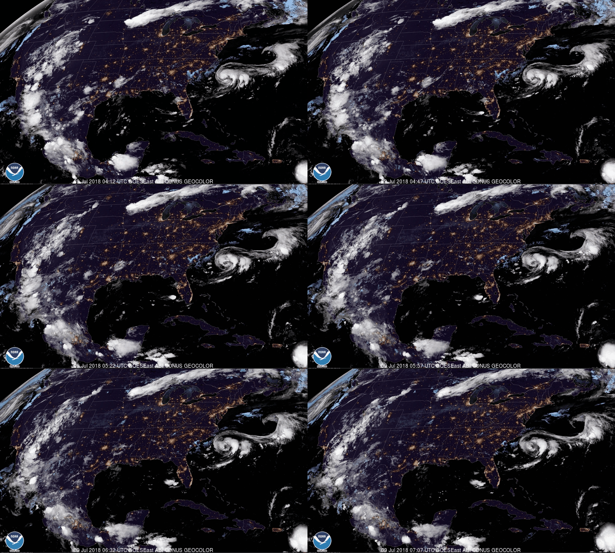
GOES-16 GeoColor - True Color daytime, multispectral IR
12:12 to 3:07 am this morning


HAZARDS

Hazardous weather is not expected.

Macon Media maintains a Severe Weather Preparedness Page at http://thunderpigblog.blogspot.com/p/breaking-news-hub.html for those who are interested.

As always, you can check to see what advisories, watches, and warnings are in effect for Macon County by visiting http://is.gd/MACONWARN


GOES 16 - Band 15 - 12.3 µm - Dirty Longwave Window - IR (Precipitation)
3:12 am this morning

TROPICAL OUTLOOK


Tropical Weather Outlook
NWS National Hurricane Center Miami FL
200 AM EDT Mon Jul 9 2018

For the North Atlantic...Caribbean Sea and the Gulf of Mexico:

The National Hurricane Center is issuing advisories on Tropical Storm Chris, located a couple of hundred miles south-southeast of the North Carolina Outer Banks.

1. The National Hurricane Center has issued the last advisory on the remnants of Tropical Storm Beryl, located over the northeastern Caribbean Sea. Disorganized thunderstorms and gusty winds associated with the remnants of Beryl are forecast to move west-northwestward and spread over the Virgin Islands and Puerto Rico today, and over Hispaniola tonight. Unfavorable upper-level winds and interaction with land should prevent redevelopment during the next day or two, but environmental conditions could become somewhat conducive for regeneration of a tropical cyclone later this week when the system is forecast to turn northward over the Bahamas and the western Atlantic.

* Formation chance through 48 hours...low...near 0 percent
* Formation chance through 5 days...low...30 percent


MACON CALENDAR

If you have an event you wish to be added to this calendar, please send the information, along with a flyer in pdf format or a high-quality photo, to editor@maconmedia.com. If you want text published, please include a paragraph with your photo, flyer or graphics. Please include date(s) and time(s).
There is no charge for civic, educational or nonprofit groups, except for groups or events that receive funding from the TDA, TDC, and EDC, where full rates apply.

Organizers of political events must make themselves available for a video interview at least 7 days before a political event they wish Macon Media to promote. Two weeks is the preferred time frame to maximize awareness.


FRIENDS OF THE GREENWAY BUTTERFLY GARDEN RENEWAL CELEBRATION DAY

Friends of the Greenway is having a Butterfly Garden Renewal Celebration Day on Tuesday, July 10, 2018 from 9 AM to 11 AM. There will be a Ribbon Cutting at 9:30 AM to welcome the community to the renovated garden. Bringing back the eleven-year-old garden was funded in part with a grant from the Macon County Unrestricted Endowment Fund which is administered by the North Carolina Community Foundation. Find out about the butterflies that can be found in the area and the plants that maintain their lifecycle. Park behind the Shops at Riverwalk on Highlands Road. Follow the Greenway trail for a short distance--just past the Rotary Shelter. Rain date is Wednesday, July 11.

Suminski Family Books Summer Film Fest for Families

All ticket sales sold by FROG volunteers benefit:

FRIENDS OF THE GREENWAY, INC.

Location: Smoky Mountain Center for the Performing Arts
Start time for each movie: 7:00 PM
Save When You Pre-Buy Your Tickets!

Single Ticket $5 for each movie (pre & at the door)
Season Pass $15 1 ticket to each movie Family of 4 Season Passes $50 4 tickets to each movie

Movies and Dates:

Paddington 2 on July 12, 2018
Hidden Figures on July 19, 2018
Peter Rabbit on August 19, 2018
Wonder on August 26, 2018 (benefits Friends of the Greenway)

Purchase at FROG Quarters, 573 E. Main (next to new bridge) Hours: Wed-Fri, 9 AM-2 PM

There are 3 other non-profits involved: Folk Heritage Association of Macon County NC, Grandpa’s Woodshed Project, Women’s History Trail, and Read2Me. The FROG-specific specific movie is Wonder, but our members can pre-sell tickets to all movies.


Uptown Gallery classes
(These are on-going classes – repeat weekly)

Free classes and open studio times are being offered at The Uptown Gallery in Franklin. Join others at a painting open studio session every Tuesday from 6:30 pm – 9:00 pm or on Thursday from 11:00 am – 3:00 pm.
Bring your own materials and join an on-going drawing course led by gallery artists on Fridays, from 11am – 2 pm. For information on days open, hours and additional art classes and workshops, contact the gallery on 30 East Main Street at (828) 349 – 4607.

National Alliance on Mental Illness
Appalachian South


Meets each Thursday at 7pm
The First Methodist Church Outreach Center
at the intersection of Harrison Ave. and West Main Street
(directly across from Lazy Hiker Brewery)

Come join our weekly support group for anyone suffering from mental illness and their family or friends. This includes Depression, Bipolar,8chizophrenia, PTSD, Substance Abuse, Etc.

Here you will find:
— others living with mental health challenges YOU ARE NOT ALONE
- learn coping skills and ?find hope in shared experience
- help learning how to break down stigma and guilt surrounding mental health
- how to live life with the expectation of a better a better future

Kay (706)970-9987 Denise (828)347-5000)

SYRINGE EXCHANGE PROGRAM

On January 1, 2017, the Syringe Exchange Program of Franklin began operating a comprehensive harm reduction program to address the opioid epidemic that is impacting western NC. Opioid overdose reversal kits including naloxone are available free of charge. If you have any questions about our services or if you know someone interested in volunteering, please contact Stephanie Almeida at 828-475-1920.


Sun and Moon

Sun

Begin civil twilight 5:57 a.m.
Sunrise 6:27 a.m.
Sun transit 1:39 p.m.
Sunset 8:50 p.m.
End civil twilight 9:20 p.m.


Moon

Moonrise 3:18 a.m.
Moon transit 10:13 a.m.
Moonset 5:14 p.m.


Phase of the Moon on July 9, 2018: Waning Crescent with 17% of the Moon's visible disk illuminated.
Closest Primary Moon Phase: Last Quarter on July 6, 2018 at 3:51 a.m. (local daylight time)

Sky Guides for this week


Sky and Telescope Magazine 
Astronomy Magazine


There will be three solar and two lunar eclipses in 2018. [LINK]

Heavens Above has an Android App that will assist you in observing the sky and even has a satellite tracker that will let you know when the International Space Station and dozens of other satellites are overhead. [LINK]

Stellarium is also an app that will assist you in observing the sky. It is available in both Android [LINK] and iOS versions. [LINK]

CROWDFUNDING OR DAY SPONSORSHIP OPPORTUNITIES


If you receive value from what Macon Media provides to the community, please consider becoming a supporter and contribute at least a dollar a month.


Become a Patron!

If you have a business or event you are interested in sponsorship opportunities or underwriting coverage, send an email to editor@MaconMedia.com for more information. Serious inquiries only. Macon Media rewards early sponsors/underwriters with lifetime guaranteed low rates while newer sponsors/underwriters pay higher rates based on the date they first support Macon Media.

Thank You to the people who have been sending in donations and those businesses who are underwriting coverage of news and events. You have kept Macon Media online.

Learn more about becoming a patron of Macon Media at https://www.patreon.com/MaconMedia

Published at 3:45 am on July 09, 2018

#WNCscan #MaconWx #MaconSafety


Data and information sources: Sources (except where otherwise credited): heavens-above.com, Ian Webster's Github, National Centers for Environmental Prediction, The National Weather Service, National Oceanic Atmospheric Administration, National Hurricane Center, Penn State University Electronic Wall Map, The State Climate Office of North Carolina, Storm Prediction Center, U.S. Naval Observatory, University of Utah Department of Atmospheric Sciences, and the Weather Prediction Center.