Notice

I am working on the template of this blog today in order to chase down some problems that have developed with my template and widgets.

Macon County Commissioners

Coverage of the meetings of the Macon County Board of County Commissioners.

Franklin Town Board of Aldermen

Coverage of the meetings of the Franklin Town Board of Aldermen.

Macon County School Board

Coverage of the meetings of the Macon County School Board.

Photoblog

Photos from my photoblog.

nullspace for future use

nullspace for future use

About

Showing posts with label Aircraft Crash. Show all posts

Friday, March 10, 2023

Four Survive Life Force 6 Crash on Middle Burningtown Road in Macon County


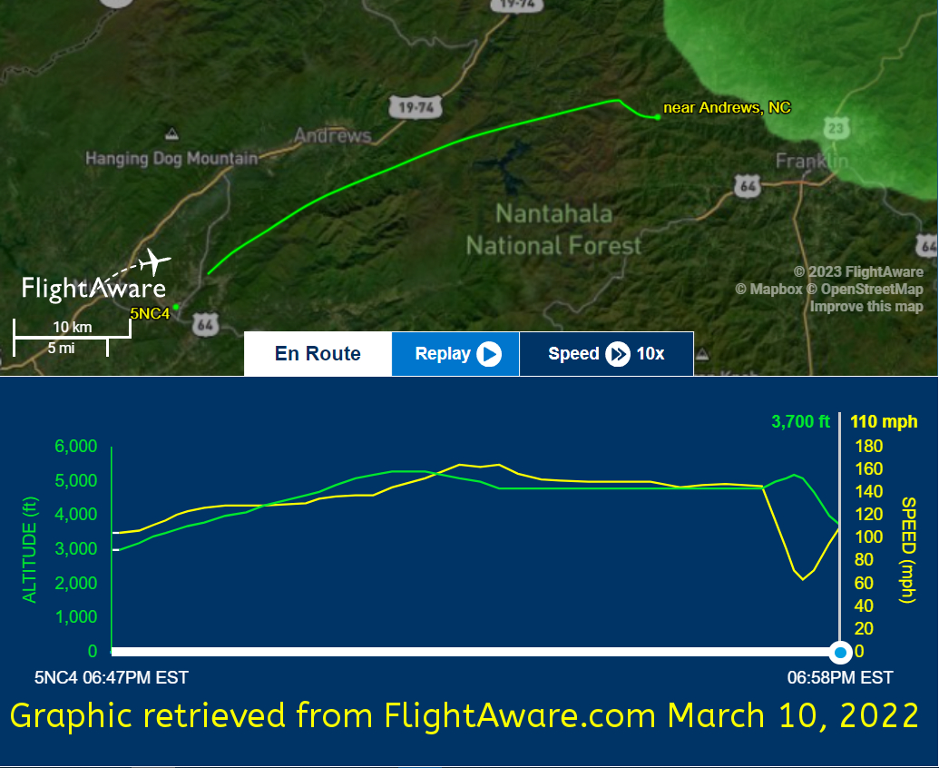
According to flight logs, at about 6:58pm last night, a medical helicopter (a Eurocopter EC135 P2+) operating under the Callsign Lifeforce-6 made a crash landing on Middle Burningtown Road last night. 

Two crew members and a patient being transported from Murphy Medical Center to Memorial Mission in Asheville were then transported to Memorial Mission in Asheville with minor to moderate injuries. One patient was transported to Angel Medical Center. In a press release, Emergency Management Director Warren Cabe said that Middle Burningtown Road would be closed until after an investigation had been completed on Friday. 

According to FAA and NTSB Databases, there are no previous accidents involving N558MT.

DAY SPONSOR


Macon Media is being underwritten today by Franklin Office Supply. Visit their store at 161 Highlands Road in Franklin or check out their website.


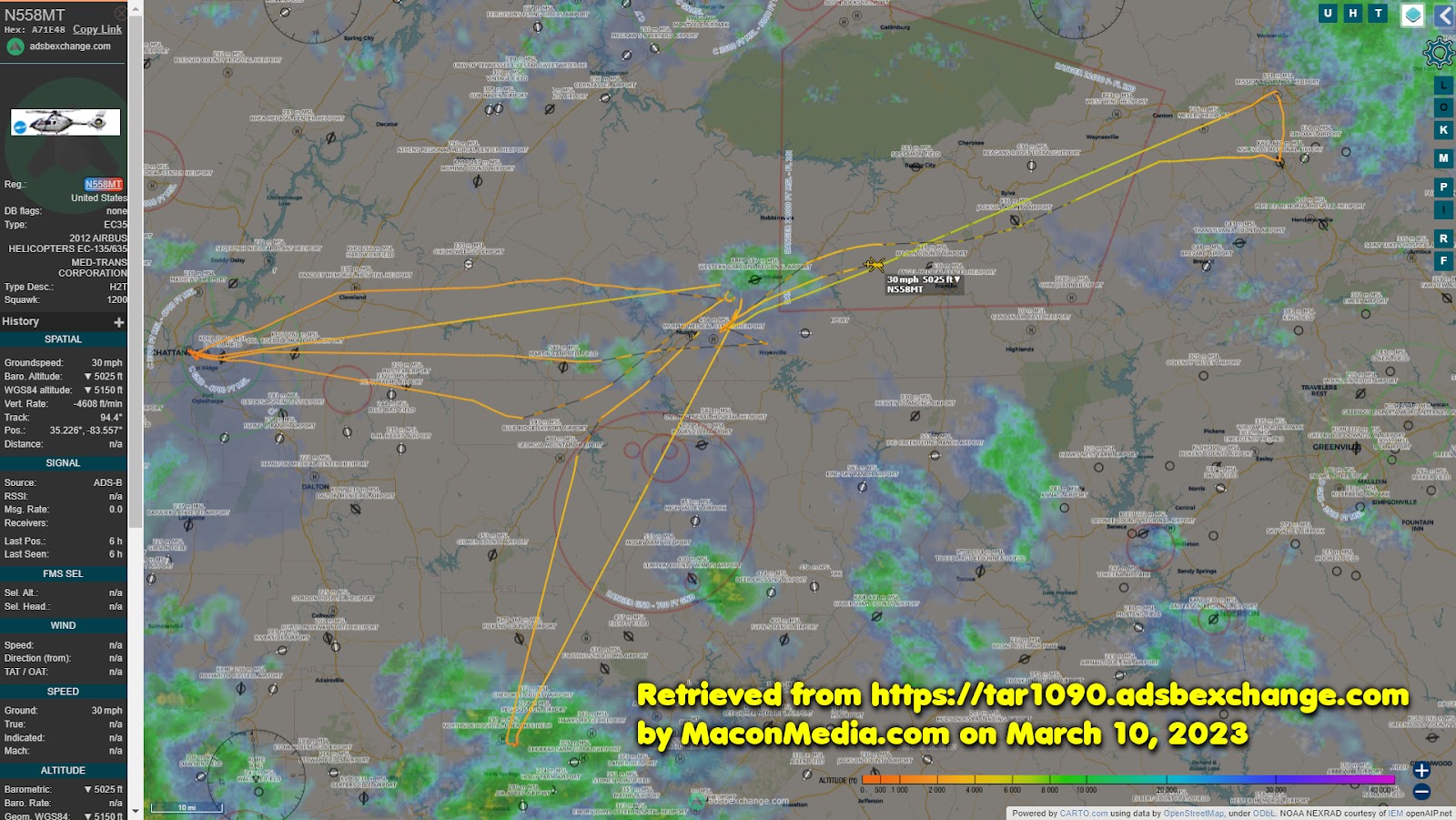
Below are various items related to the crash, including a press release, audio of the initial callout, information about the last flight obtained from flight trackers, and a history of the airframe from the Federal Aviation Administration. 

Macon County EMS and Burningtown-Iotla VFD Dispatched


Press Release
Macon County Emergency Services
March 9, 2023
Warren Cabe, Director


Investigators will be on scene of an aircraft crash in Macon County on Friday. A medical transport helicopter crashed west of the Macon County Airport in the Burningtown community around 7 PM. The aircraft was transporting a patient and three crew members and was enroute from a medical facility in Murphy, N.C. to Mission Hospital in Asheville, N.C. Three individuals involved were transported by ground ambulance to Mission Hospital with minor to moderate injuries and one patient was transported to Angel Medical Center for evaluation.

There were no fatalities and no fire although the aircraft sustained severe damage. A section of Middle Burningtown Road will be closed until at least late day on Friday as investigators sift through the wreckage and work to determine the cause of the accident.


Altitude and Speed Tracking for the last flight of N558MT.



Here are the flights taken by Life Force 6 on March 9, 2023.


And here is a registration history for the helicopter that includes previous owners of the airframe.
Dates Entity and Location
26-Sep-2022 Med-Trans Corporation in Denton TX
28-Mar-2017 TVPX Aircraft Solutions Inc Trustee in North Salt Lake UT
06-feb-2015 Wells Fargo Bank Northwest National Trustee in Salt Lake City UT
30-nov-2012 Wells Fargo Bank Northwest National Trustee in Lewisville TX
12-oct-2012 Wells Fargo Bank Northwest National Trutee in Lewisville TX
17-aug-2012 American Eurocopter Corp in Grand Prairie TX


Here are other news sources regarding the crash.

• N558MT Crash [Aviation Safety Network]


• LIFE FORCE helicopter carrying patient crashes in Macon County [WLOS-TV (Asheville, NC)]


Support Macon Media

If you receive value from what Macon Media provides to the community, please consider becoming a supporter and contribute at least a dollar a month. Those who support Macon Media with at least a dollar a month receive early access to video of some events and meetings before they are made public on the website. Videos and news involving public safety are not subject to early access.


Become a Patron!


Or, if you prefer Pay Pal, try PayPal.me/MaconMedia


Published at 5:01am on Friday, March 10, 2023
Author: Bobby Coggins


Thursday, March 11, 2021

No Injuries From Aircraft Crash at Macon County Airport


At 3:15pm on Thursday, March 11, 2021, there was a report of an aircraft crash at the Macon County Airport. [LINK] A Cessna 421B (tail registration N80056) owned by DuoTech of Franklin ran off the runway this afternoon, sliding in a field for some distance before knocking over a fence and coming to rest in a corner of Liberty Wood Products. According to an eyewitness, there was a pilot and two passengers onboard the aircraft. Everyone on the aircraft exited the plane without injury before fire consumed the twin-engine Cessna. The day before the crash, the aircraft had completed a 52-minute flight testing the "Cessna Airborne Radar Test Platform" on a flight that took it into Georgia and back from 2:01pm to 2:53pm.


DAY SPONSOR

Macon Media is being underwritten today by Franklin Health and Fitness, home of #ResultsForEveryone. Try FHF with a FREE 3-Day Guest Pass! To claim your pass, and to learn more about Franklin Health and Fitness, visit franklinhealthandfitness.com.


Macon County EMS, Franklin Fire Department, Burningtown Fire Department, Cowee Fire Department, and West Macon Fire Department responded to assist with extinguishing the fire. The Fire Marshall and other personnel established a hazard mitigation downstream from the crash in case fuel leaked into Iotla Creek, which runs to the northeast and drains into the Little Tennessee River. The Macon County Sheriff's Office responded to provide scene security and the North Carolina Highway Patrol responded with several units to gather information for the investigation. One trooper was observed measuring the distance the aircraft slid before coming to rest. The FAA (Federal Aviation Administration) and the NTSB (National Transportation Safety Board) will conduct a thorough investigation and Macon Media will share that information once it is released.


Here is a preliminary report of the incident from the NC Highway Patrol:

At about 3:16 p.m. the North Carolina State Highway Patrol responded to an aircraft crash at the Macon County Airport. A twin-engine Cessna 421 B was attempting to take off and ran off the end of the runway catching fire and sustained extensive damage. The pilot of the aircraft and two passengers escaped the aircraft without injuries. The incident is currently being investigated by the FAA and NTSB.


Nine years ago (on March 16, 2012), five people were killed in a crash at the airport. [LINK]

A pilot walked away from a crash landing near the Ledford Stretch section of the Georgia Road (US-441) on November 16, 2018.[LINK]


CROWDFUNDING OR DAY SPONSORSHIP OPPORTUNITIES


If you receive value from what Macon Media provides to the community, please consider becoming a supporter and contribute at least a dollar a month. Those who support Macon Media with at least a dollar a month receive early access to video of some events and meetings before they are made public on the website. Videos and news involving public safety are not subject to early access.


Become a Patron!


Or, if you prefer Pay Pal, try PayPal.me/MaconMedia

Published at 8:25pm on Thursday, March 11, 2021

Saturday, March 16, 2019

Daily Weather Briefing for Saturday, March 16, 2019
Aircraft Crash Located in Jackson County


Overdue Aircraft Found Near Whiteside Mountain

Late Thursday afternoon, Gary Huttleston took off from the airport on Knoxville Downtown Island Airport in his 1965 Mooney M20C single-engine piston aircraft. His intended destination was his home airport in Aiken, SC with an estimated arrival time of 7:01 pm. The Federal Aviation Administration issued an alert about the missing aircraft and local Emergency Management, Fire Departments, Rescue Squads, and Sheriff Offices in the area began looking for the aircraft Thursday night near the last known location according to its ADS-B transmitter. Bad weather forced the search to be called off that night, then the search was resumed Friday morning. The aircraft was located in Jackson County around 12:45 pm Friday afternoon. The pilot did not survive the crash. The NTSB out of Atlanta was called to the scene to conduct an investigation and firefighters and rescue personnel were called in to remove the body from the crash. The image with this segment shows the flight path of the aircraft as reported by an onboard ADS-B transmitter. The flight path is in green.


Outlook

Quiet weather with sunny skies will prevail through at least early next week.


THREE DAY GFS FORECAST
This animated image shows a forecast of precipitation, air pressure and thickness level (cold-air damming) for three days in six-hour increments.
Green, Yellow, and Red indicate rain. Orange and Purple Indicate Freezing Rain or other freezing precipitation. Blue indicates snow.


WEATHER SPONSOR


Adams Products, a Division of Oldcastle is underwriting the daily weather briefing & public safety updates for the month.

Open 7:30 AM to 4:00 PM, M-F, located at 895 Hickory Knoll Road, Franklin, NC. Visit our Facebook page at:
https://www.facebook.com/Adams.Oldcastle.Franklin.NC/

All your masonry needs are available. Our phone number is 828.524.8545, the public is welcome, we’ll help you with your with your next project.


Weather Hazards

Hazardous weather is not expected. Dry weather should dominate the local weather pattern for the next several days.


CROWDFUNDING OR DAY SPONSORSHIP OPPORTUNITIES


If you receive value from what Macon Media provides to the community, please consider becoming a supporter and contribute at least a dollar a month. Those who support Macon Media with at least a dollar a month receive early access to video of some events and meetings before they are made public on the website. Videos and news involving public safety are not subject to early access.

Patreon Subscriber History May 2014 to Present


Become a Patron!

If you have a business or event you are interested in sponsorship opportunities or underwriting coverage, send an email to editor@MaconMedia.com for more information. Serious inquiries only.

Thank You to the people who have been sending in donations and those businesses who are underwriting coverage of news and events. You have kept Macon Media online.


WEATHER FORECAST MAPS

Forecast maps for 7 am, 1 pm, and 7 pm.
[click on any image in this article to enlarge]


FRANKLIN AREA FORECAST

Today

Mostly sunny, with a high near 55. Winds out of the northwest around 8 mph.

Tonight

Mostly clear, with a low in the upper 20s. Light winds out of the northwest.

Sunday

Sunny, with a high near 55. Calm winds rising to come out of the west around 5 mph in the afternoon.

Sunday Night

Mostly clear, with a low around freezing. Winds out of the northwest around 5 mph.

Monday

Sunny, with a high in the lower 50s.

Monday Night

Mostly clear, with a low around 30.


OTTO AREA FORECAST

Today

Mostly sunny, with a high near 55. Winds out of the northwest around 8 mph.

Tonight

Partly cloudy, with a low around 30. Winds out of the northwest 3 to 5 mph.

Sunday

Sunny, with a high near 55. Calm winds in the morning and then winds out of the west around 5 mph in the afternoon.

Sunday Night

Mostly clear, with a low around freezing. Winds out of the northwest around 6 mph.

Monday

Sunny, with a high in the lower 50s.

Monday Night

Mostly clear, with a low around 30.


HIGHLANDS PLATEAU FORECAST

Today

Mostly sunny, with a high in the upper 40s. Winds out of the northwest 5 to 15 mph, with gusts as high as 30 mph.

Tonight

Partly cloudy, with a low in the upper 20s. Winds out of the northeast 3 to 6 mph.

Sunday

Sunny, with a high in the upper 40s. Winds around 5 mph out of the southwest early, then shifting to come out of the northwest by midmorning.

Sunday Night
5 to 10 mph.

Monday

Sunny, with a high near 45. Winds out of the northwest 5 to 10 mph, with gusts as high as 20 mph.

Monday Night

Mostly clear, with a low in the mid-20s.


NANTAHALA AREA FORECAST


Today

Mostly sunny, with a high in the upper 40s. Winds out of the northwest 5 to 10 mph.

Tonight

Partly cloudy, with a low in the upper 20s. Winds out of the north 3 to 5 mph.

Sunday

Sunny, with a high in the lower 50s. Calm winds in the morning, then winds around 5 mph out of the northwest in the afternoon.

Sunday Night

Mostly clear, with a low around 30. Winds out of the northwest around 5 to 10 mph.

Monday

Sunny, with a high near 45. Winds out of the northwest 5 to 10 mph.

Monday Night

Mostly clear, with a low in the mid-to-upper 20s.


Macon County Almanac for March 16, 2019

Highest Temperature 82°F at the Coweeta Experimental Station in 2016
Lowest Temperature 6°F in Highlands in 1916
Greatest Rainfall 4.10 inches in Franklin in 1880
Greatest Snowfall 3.3 inches in Highlands in 1915


Weather Extremes for Macon County for the month of March
Data available from 1873 to 2018

Highest Temperature 86°F at the Coweeta Experimental Station on 03-15-1967
Lowest Temperature -7°F in Highlands on 03-07-1899
Greatest Rainfall 6.43 inches in Highlands on 03-29-1898
Greatest Snowfall 25.5 inches at the Coweeta Experimental Station on 03-13-1993


Published at 4:47 am on March 16, 2019

Saturday, November 17, 2018

Daily Weather Briefing for Saturday, November 17, 2018
Pilot Walks Away From Crash Landing North of Otto


Pilot Walks Away From Crash Landing in Pasture

Photo of plane crash provided

A pilot lost power in his Cessna Skycatcher (registration N70252) Friday morning and was forced to make an emergency landing north of Otto next to a stretch of highway known as “the Ledford Stretch.” The pilot brought the plane down in a cow pasture and the plane bounced over the highway, flipping over and landed on its top. Doug Finner, the pilot, was wearing his seatbelt and survived the crash without injury. Otto Fire Department, Squad 4, and Macon County EMS were dispatched to the scene at 10:05 am.


Above is video shot by Karcher Aerial Imagery of the crash site. More photos shot from the air can be seen on Facebook. [LINK]

screenshot of N70252 rental page

The pilot was flying from Lee Gilmer Memorial Airport near Gainesville, Georgia to the Macon County Airport. The plane was a rental from Lanier Equipment Leasing, LLC located in Gainesville, Georgia. [LINK]

A preliminary narrative of events was posted online at the Aviation Safety Network, a website operated by the Flight Safety Foundation. The information will be updated after the FAA and NTSB finish their investigation of the incident. [LINK]


Macon Media live-blogged the response on Facebook. [LINK]

Six and a half years ago, on March 15,2012 a small jet crash killed five people at the Macon County Airport. [LINK]


Outlook

A gradual warming trend will develop over the weekend ahead of a weak cold front approaching from the west. The front will move through the area on Monday, with moisture mainly limited to the mountains. A dry, reinforcing cold front will arrive from the northwest on Wednesday. Lows this week will range from around freezing to the upper 30s and the highs will range from the mid-50s in the higher elevations to near 60 in the lower elevations.

THREE DAY GFS FORECAST
Testing a new feature that shows a forecast of precipitation, air pressure and thickness level (cold-air damming) for three days in six-hour increments.
Green, Yellow and Red indicate rain. Orange and Purple Indicate Freezing Rain or other freezing precipitation. Blue indicates snow.


WEATHER SPONSOR


Adams Products, a Division of Oldcastle is underwriting the daily weather briefing & public safety updates for the month.

Open 7:30 AM to 4:00 PM, M-F, located at 895 Hickory Knoll Road, Franklin, NC. Visit our Facebook page at:
https://www.facebook.com/Adams.Oldcastle.Franklin.NC/

All your masonry needs are available. Our phone number is 828.524.8545, the public is welcome, we’ll help you with your with your next project.


Weather Hazards

Hazardous weather is not anticipated today.


WEATHER FORECAST MAPS

Forecast maps for 7 am, 1 pm, and 7 pm.
[click on any image in this article to enlarge]


FRANKLIN AREA FORECAST

Today

Sunny, with a high near 60. Calm wind.

Tonight

Clear, with a low around 35. Calm wind.

Sunday

Mostly sunny, with a high near 60. Light and variable wind.

Sunday Night

Partly cloudy, with a low around 35. Calm wind.

Monday

Mostly sunny, with a high near 60.

Monday Night

Partly cloudy, with lows in the upper 30s.


OTTO AREA FORECAST

Today

Sunny, with a high near 60. Light and variable wind.

Tonight

Mostly clear, with a low around 35. Calm wind.

Sunday

Mostly sunny, with a high near 60. Light and variable wind.

Sunday Night

Partly cloudy, with lows in the upper 30s. Calm wind.

Monday

Mostly sunny, with a high near 60.

Monday Night

Partly cloudy, with a low around 40.


HIGHLANDS PLATEAU FORECAST

Today

Sunny, with a high in the lower 50s. Northwest wind around 5 mph becoming light and variable in the late afternoon.

Tonight

Mostly clear, with a low around 35. Light winds out of the west.

Sunday

Mostly sunny, with a high in the lower 50s. Calm wind shifting to come out of the south-southwest around 5 mph in the afternoon.

Sunday Night

Partly cloudy, with a low in the upper 30s. Winds out of the southwest 3 to 5 mph.

Monday

Mostly sunny, with a high in the lower 50s.

Monday Night

Partly cloudy, with a low around 35.


NANTAHALA AREA FORECAST

Today

Sunny, with a high near 55. Calm wind shifting to come out of the west-southwest around 5 mph in the afternoon.

Tonight

Mostly clear, with a low around 35. Light and variable wind.

Sunday

Mostly sunny, with a high near 55. Calm wind shifting to come out of the west-southwest around 5 mph in the afternoon.

Sunday Night

Partly cloudy, with a low in the upper 30s. Calm wind.

Monday

A 20 percent chance of showers after 4pm. Partly sunny, with a high near 55.

Monday Night

Mostly cloudy, with a low around 35.


CROWDFUNDING OR DAY SPONSORSHIP OPPORTUNITIES


If you receive value from what Macon Media provides to the community, please consider becoming a supporter and contribute at least a dollar a month.


Become a Patron!

If you have a business or event you are interested in sponsorship opportunities or underwriting coverage, send an email to editor@MaconMedia.com for more information. Serious inquiries only. Macon Media rewards early sponsors/underwriters with lifetime guaranteed low rates while newer sponsors/underwriters pay higher rates based on the date they first support Macon Media.

Thank You to the people who have been sending in donations and those businesses who are underwriting coverage of news and events. You have kept Macon Media online.

Published at 3:35 am on November 17, 2018 
Link to live-blog added at 3:48 am

Friday, March 16, 2012

Plane Crash Kills Five at Macon County Airport

**update** Some of the regional TV Stations have uploaded video to the internet that is embeddable on other websites and here they are...

Fox Carolina


WSPA


The "local" TV Station, WLOS has video, but it is not embeddable, so I won't link to it. The same with WYFF.

**update** Macon County News has an article and a video interview with Neil Hoppe, the manager of the Macon County Airport. [link]


Photo of plane crash posted on Facebook by Taylor Fenoglio at 2:09pm. [link]


I was monitoring my scanner yesterday afternoon and noted a radio communication at about 1:45pm on 123.050 Mhz, the frequency used by the Macon County Airport. The communication was brief, most of it unintelligible by me due to the accent of the pilot. The only words I could make out were "runway two five" and I tweeted about the radio traffic on my Twitter Account I use for reporting what I monitor on the airwaves.


A couple of minutes or so after I tweeted, the Macon County Emergency Operations Center (EOC) dispatched the Franklin Fire Department to a report of a plane crash at the Macon County Airport. I immediately pulled up an online scanner feed for Macon County that is run by a friend and started recording. I've posted the entire chain of my tweets in reverse chronological order at the end of this post.


Here is a recording of the public safety radio traffic with all the long pauses and other non-related radio traffic edited out of the first 15 minutes after the plane crash:


I also updated a Facebook Page I maintain with details of what I learned during the course of the event. [link]


According to information I gleaned from Facebook (by far and away the best source of quick information during this event due to the large number of locals using the social media platform) there were two couple and a small female child aboard the plane. My heart goes out to the families who lost loved ones and to the responders who had to sift through the wreckage to discover the remains of those killed in the crash.


Here is the flight altitude and speed profile of the last flight of N7700T as recorded by Flight Aware, an online flight tracker:


Here is what other media outlets reported about the crash:

WLOS-TV


Authorities now say five bodies were recovered from the wreckage of the plane crash in Macon Co.  The plane was registered to a Bogdan Jakubowski of Venice, Florida.  But the identities of those killed have not yet been released.  

According to the Macon Co. 911 coordinator, the plane was attempting to land around 1:45pm, but appeared to approach at too steep an angle.  The pilot tried to correct, but one of the wings dipped causing the plane to flip and explode. 


Fire News also reported on the crash, but erroneously reported that Burningtown VFD was the lead agency.

ABC News (via the AP) also reported on the crash.


Initial Twitter Coverage of Events

 Franklin VFD dispatched to report of plane crash at the Macon County Airport. Plane fully involved. cc 


 Medic 9 reports observing lots of black smoke from town.


 Burnington VFD member #1510 advises the plane is at the end of the runway in the cornfield.


 Medic 9 has requested that traffic be denied to travel the Airport Rd to allow emergency vehicles through


 Burningtown VFD member #1510 advises the plane is fully involved, numerous small explosions occurring.


 Franklin VFD truck#1150 advises all emergency traffic take Windy Gap Rd and avoid Highway 28.  construction hazard.


 RT  Airport rd will closed to through traffic due to plane crash.


 RT  Smoke from the plane crash at the Macon County Airport via WPFJ-AM webcam
Smoke from the plane crash at the Macon County Airport via WP... on Twitpic
2:12 PM - 15 Mar 12 via Mobile Web · Details


 Clarks Chapel VFD has been dispatched to standby for calls in the Town of Franklin while they respond to a plane crash.
 Freqs for crash at Macon Co Airport: Dispatch-453.350 Franklin TAC-453.2375 & 453.900 Sheriff-460.3125 EMS-155.325 Airport-123.050


Bookmark and Share
