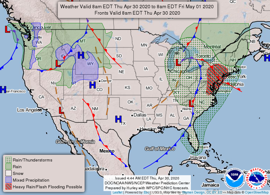
A strong cold front will cross the area and will bring rain and isolated thunderstorms today into tonight. Cool and breezy conditions are expected behind the front Thursday into Friday. Warm and dry high pressure will settle over the region and provide a significant warmup late in the weekend and early next week.
Macon County to rescind Emergency Regulations that go beyond the state restrictions on May 8th, to follow state plan to re-open in phases. [LINK]
---BEGIN SPONSOR SEGMENT ---
DAY SPONSOR
Macon Media is being underwritten today by Franklin Health & Fitness, home of #ResultsForEveryone, and the FREE 7-Day Guest Pass.
During this public health emergency, Franklin Health and Fitness has made the difficult decision to temporarily close due to the continued risk surrounding COVID-19. To see updates related to COVID-19, please click: http://franklinhealthandfitness.com
Adams Products, a Division of Oldcastle is underwriting the daily weather briefing & public safety updates for the month.
Open 7:30 AM to 4:00 PM, M-F, located at 895 Hickory Knoll Road, Franklin, NC. Visit our Facebook page at:
https://www.facebook.com/Adams.Oldcastle.Franklin.NC/
All your masonry needs are available. Our phone number is 828.524.8545, the public is welcome, we’ll help you with your next project.
---END SPONSOR SEGMENT---
General Forecast Through Friday
Today
Patchy fog this morning. Mostly cloudy with a 20 percent chance of showers. Highs ranging from the upper 50s to the lower 60s. Winds out of the northwest 10 to 15 mph with winds gusting to 20 to 25 mph between 3pm and 8pm.
Tonight
Mostly cloudy with a 40 percent chance of showers. Lows ranging from the lower 40s to the upper 30s. Winds out of the northwest 10 to 15 mph with gusts up to 25 mph before 8pm.
Friday
Mostly sunny. Highs ranging from the upper 50s to the lower 60s. Winds out of the northwest 10 to 15 mph with gusts up to 30 mph.
Friday Night
Mostly clear. Lows ranging from the mid-40s to the upper 30s. Winds out of the northwest 10 to 15 mph with gusts up to 25 mph, shifting to come out of the north around 5 mph after midnight.
Saturday
Mostly sunny. Highs ranging from the upper 60s to the lower 70s. Winds out of the northwest winds around 5 mph.
Saturday Night
Mostly clear. Lows around 50.
Hazards
Hazardous weather is not anticipated for today.
End Daily Weather Segment
CROWDFUNDING OR DAY SPONSORSHIP OPPORTUNITIES
If you receive value from what Macon Media provides to the community, please consider becoming a supporter and contribute at least a dollar a month. Those who support Macon Media with at least a dollar a month receive early access to video of some events and meetings before they are made public on the website. Videos and news involving public safety are not subject to early access.
Warren Cabe, the Emergency Management Director is rescinding the emergency regulations put in place due to the COVID-19 Pandemic effective at 5:00pm on May 8th, 2020. Copies of the press release and revocation are embedded below in the interest in transparency.
A strong cold front will cross the area and will bring rain and isolated thunderstorms today into tonight. Cool and breezy conditions are expected behind the front Thursday into Friday. Warm and dry high pressure will settle over the region and provide a significant warmup late in the weekend and early next week.
News Brief
Field Report from the North Carolina Geological Survey Regarding Recent Debris Flows [LINK] Firefighters Respond to Man Trapped at Bust Your Butt Falls [LINK] Mission Health Announces Phased Approach for Caring for Non-COVID-19 Patients [LINK] Macon County Economic Development Commission Ready to Assist Businesses in Need [LINK]
---BEGIN SPONSOR SEGMENT ---
Weather Sponsor
Adams Products, a Division of Oldcastle is underwriting the daily weather briefing & public safety updates for the month.
Open 7:30 AM to 4:00 PM, M-F, located at 895 Hickory Knoll Road, Franklin, NC. Visit our Facebook page at:
https://www.facebook.com/Adams.Oldcastle.Franklin.NC/
All your masonry needs are available. Our phone number is 828.524.8545, the public is welcome, we’ll help you with your next project.
---END SPONSOR SEGMENT---
General Forecast Through Friday
Today
A slight chance of rain before 1pm, then a chance of showers between 1pm and 4pm, then showers likely and possibly a thunderstorm after 4pm. Some of the storms could produce heavy rainfall. Increasing clouds, with highs ranging from the lower 60s to the lower 70s. Light winds out of the southeast increasing to 5 to 10 mph by midmorning. Winds could gust as high as 20 mph. ain chances increase from slight in the morning to moderate chances in the afternoon and likely in the mid and late afternoon. Rainfall amounts between a quarter and half of an inch possible.
Tonight
Patchy fog between midnight and 3am. Lows in the 40s. Calm winds in the early evening increasing to come out of the northwest around 5 mph. The chance of precipitation is 100%. Some of the storms could produce heavy rainfall. New precipitation amounts between three quarters and one inch possible.
Thursday
Partly sunny, with highs ranging from the 50s to near 60. Calm winds in the morning increasing to come out of the northwest 5 to 10 mph in the afternoon. A 40 percent chance of showers. New precipitation amounts of less than a tenth of an inch possible.
Thursday Night
Mostly cloudy, with lows around 40. Winds of the northwest 5 to 10 mph. A 30 percent chance of showers.
Friday
Mostly sunny, with highs ranging from the upper 50s to the mid-60s. Winds out of the northwest 5 to 15 mph, with gusts as high as 30 mph. A 20 percent chance of showers before noon.
Friday Night
Partly cloudy, with lows in the 40s.
Hazards
A slow-moving squall line with embedded strong to isolated severe thunderstorms is likely to push through the region this afternoon into tonight with damaging wind and an isolated tornado the main threats. Periods of heavy rain along and ahead of the squall line may result in minor flooding of small streams and urban areas.
End Daily Weather Segment
CROWDFUNDING OR DAY SPONSORSHIP OPPORTUNITIES
If you receive value from what Macon Media provides to the community, please consider becoming a supporter and contribute at least a dollar a month. Those who support Macon Media with at least a dollar a month receive early access to video of some events and meetings before they are made public on the website. Videos and news involving public safety are not subject to early access.
The North Carolina Geological Survey has completed a field report for the Macon County Emergency Management and a copy of the report has been posted below in the interest of transparency.
Preliminary Field Report
North Carolina Geological Survey
April 24, 2020
At the request of the Macon County Emergency Management Department a team of geologists from the North Carolina Geological Survey conducted field reviews and Unmanned Aerial Systems (UAS) flights on April 13, 14, 15, and 17, 2020 of the areas affected by the debris flows of April 13, 2020. Based on our investigations to date, we offer the preliminary observations and guidance as follows. Additional information may become available as our studies continue.
Considerations for all locations impacted by the April 13, 2020 debris flows:
• Our assessment of the areas did not identify any immediate threats to life safety that would prohibit the occupancy of structures other than those deemed structurally unsafe to occupy by the jurisdictional building inspector. Conditions and circumstances may change, and this assessment in NO way implies that other slope failures in the affected areas would not occur in the future.
• Residual debris could continue to affect the areas particularly after future heavy rainfall events, including runoff and sedimentation from the exposed slopes.
• Because the slopes are over-steepened in the debris flow source areas, the margins of these slopes are unsafe.
• Trees that are leaning, undercut, or have exposed roots as a result of the debris flow activity should be considered hazardous. These trees should be removed where they are near residences or roads.
Valley View Trail and Chavis Road Debris Flows
The debris flows at these locations damaged roads, private properties, and severely damaged at least two residences. We observed groundwater discharge in the slope failure initiation zones at both locations, as well as evidence for surface water runoff from areas upslope during our April 13, 2020 site visit. Increased groundwater and surface water flow in response to the heavy rainfall were factors that likely contributed to the failures. Prior ground disturbance from human activity in the debris flow source areas appeared to be minimal.
Our assessment of the areas did not identify any immediate threats to life safety that would prohibit the occupancy of structures other than those deemed structurally unsafe to occupy by the County building inspector. Conditions and circumstances may change, and this assessment in NO way implies that other slope failures in these areas would not occur in the future. Anecdotal reports by residents indicate that a slope failure occurred in the Valley View Trail area about 15 to 20 years ago.
Additional soil material could fail along the over-steepened slopes in the debris flow source areas. The material would likely move downslope along drainage ways, especially in response to heavy rainfall. Runoff and sediment from the exposed slopes could also affect travel along roads and driveways, and impede or prevent vehicular access in some instances. The debris flow deposits can be thick, wet and contain woody debris and other objects caught up in the flows; therefore, extreme caution is advised for foot traffic in these areas.
Monitoring the steep slopes in the debris flow source areas for any development of new ground cracks that could indicate the enlargement of the unstable areas is advisable. Because the slopes are over-steepened in the debris flow source areas, the margins of these slopes are unsafe, particularly for children. We observed what appeared to be pre-existing, past-active, ground displacement (scarps) in the area immediately upslope for the source area of the Chavis Road debris flow. New ground movement along these scarps may indicate enlargement of the present unstable area.
Dobson Mountain Debris Flow
The debris flow on the northwest-facing slopes of Dobson Mountain is a major event directly impacting an area of about 16.8 acres along a tributary to Cartoogechaye Creek. We understand that the inlet for the town of Franklin’s water supply is in Cartoogechaye Creek. The path of the debris flow is approximately 4,000 feet long as measured along the slope gradient, and is 250-300 feet wide in places. Unvegetated soil subject to continued erosion and sedimentation is exposed along essentially the entire 16.8 acre path. The debris flow initiated on slopes where evidence was not observed of significant road construction or site grading, such as cut and/or fill slopes. Our field investigation of the source area indicates that it is an area of past debris slide activity. Older debris flow deposits of an unknown age were also observed in the debris flow runout zone along the stream banks on the east side of the commercial facility at 595 Maxwell Home Road.
Initial estimates indicate there is a substantial amount of unstable slide debris remaining near the debris flow source area, possibly on the order of 12,000 cubic yards or more. Ponded water present in this area was visible in our April 13, 2020 UAS image, and verified in our April 14, 2020 field investigation. There is a significant potential for future debris flow activity related to this unstable mass in the source area.
There are no known residential buildings in the path of the April 13, 2020 debris flow, or possible future debris flow activity in the same drainage. The commercial facility at 595 Maxwell Home Road was impacted by the April 13th event, and extreme caution should be used in the area where debris flow deposits are piled up behind the main building. This property could be adversely affected in the event of future major debris flows. As our resources allow, the North Carolina Geological Survey is available to provide technical assistance in an Emergency Watershed Protection grant application process, and participate in discussions of possible mitigation measures as they may relate to geologic processes and materials.
Turkey Pen and Enchanted Mountain - Potts Branch Watershed
Four debris flows were identified in the Turkey Pen and Enchanted Mountain areas of the Potts Branch watershed on the southeast-facing slopes of Dobson Mountain. No imminent threat to residential structures was identified in this area.
The largest debris flow damaged the residential buildings at 504 Turkey Pen Road, and caused substantial damage to Turkey Pen Road. Our April 17, 2020 investigation of the debris flow track and source area indicated that it originated on natural, forested slopes where evidence road construction or site grading, such as cut and/or fill slopes was not observed. Oversteepened soil material remains in the scarp of the source area which will likely result in localized instability. Anecdotal reports by residents indicate that a slope failure like a debris flow occurred in the lower Turkey Pen Road area about 15 to 20 years ago. We identified three debris flows in the Enchanted Mountain area that resulted in damage to Enchanted Mountain Road, and to a residential well house and well head adjacent to the road. Future movement of exposed soil from the debris flow path above that location could potentially impact the well head.
Road-related slope failures on Trimont Mtn. Road and Doghobble Drive (Wildflower) Road-related failures at both locations mobilized into rapidly moving debris flows that impacted properties outside of the road corridors. The over-steepened slopes immediately below the road travel ways are unstable, and the potential for further failures, and subsequent loss of the travel way exists until the slopes are adequately repaired. Both locations are generally unsafe for vehicular traffic for the conditions observed on our field visits to Trimont Mountain Road on April 15th and Doghobble Drive on April 17th, 2020.
Evidence of groundwater seepage was observed in the slope failure initiation zones at both locations, and was likely a factor contributing to the failures. Road repair methods and materials should take into account the adequate long-term management of groundwater and surface water at both locations. The culvert was plugged at the Trimont Mountain road location, which likely resulted in storm water traveling over the roadway and onto the road embankment contributing to the failure. It is advisable to replace the existing culvert with a larger diameter one that is better positioned to capture inlet flow, along with adequate erosion protection at the outlet. Ideally, road-related slope repairs at both locations would be done under the guidance of a licensed geotechnical engineer. The debris flows stripped vegetation and surface soil along their paths. Revegetation of the track areas for erosion control is advisable to reduce further erosion and stream sedimentation.
The road failure on Trimont Mountain Road caused sedimentation into the impoundment behind Trimont Mountain dam (LQS Macon-044). A DEQ Land Quality Section inspector visited the dam on Friday, April 17, 2020 and determined that the dam itself was not impacted by the debris flow. The impoundment did receive sediment but there were no impacts to dam-related infrastructure from the debris flow. The Trimont Mountain road failure is upslope of the Trimont Mountain Dam; therefore it is important that the road repair is stable over the long term.
Seasonably cool and breezy conditions are expected across our region today. Expecting a bit milder temperatures on Tuesday. The next shot at widespread rain will arrive by late Wednesday as a cold front reaches our area.
---BEGIN SPONSOR SEGMENT ---
Weather Sponsor
Adams Products, a Division of Oldcastle is underwriting the daily weather briefing & public safety updates for the month.
Open 7:30 AM to 4:00 PM, M-F, located at 895 Hickory Knoll Road, Franklin, NC. Visit our Facebook page at:
https://www.facebook.com/Adams.Oldcastle.Franklin.NC/
All your masonry needs are available. Our phone number is 828.524.8545, the public is welcome, we’ll help you with your next project.
---END SPONSOR SEGMENT---
General Forecast Through Thursday
Today (Frost Advisory until 9am)
Mostly sunny. Highs ranging from the mid-60s to the lower 70s. Winds out of the southwest 5 to 10 mph.
Tonight
Partly cloudy in the evening, then becoming mostly cloudy. Lows ranging from the lower 50s to the mid-40s. Winds out of the south 5 to 10 mph.
Wednesday
A chance of rain in the morning, then showers with a chance of thunderstorms in the afternoon. Highs ranging from the upper 50s to the upper 60s. Winds out of the south 10 to 15 mph with gusts up to 40 mph. Chance of rain near 100 percent. Rainfall amounts of around an inch possible.
Wednesday Night
Showers with a chance of thunderstorms in the evening, then showers likely after midnight. Lows ranging from the mid-40s to the upper 30s. Winds out of the southwest 5 to 10 mph. Gusts up to 30 mph in the evening. Chance of rain 90 percent.
Thursday
Partly sunny with a 50 percent chance of showers. Highs in the 50s. Winds out of the west 5 to 10 mph. Gusts up to 25 mph in the afternoon.
Thursday Night
Partly cloudy. A chance of rain showers in the evening. Lows ranging from around 40 to the mid-30s. Chance of rain 40 percent.
Hazards A Frost Advisory is in effect until 9am this morning for scattered frost. Other than that, hazardous weather is not expected today.
End Daily Weather Segment
CROWDFUNDING OR DAY SPONSORSHIP OPPORTUNITIES
If you receive value from what Macon Media provides to the community, please consider becoming a supporter and contribute at least a dollar a month. Those who support Macon Media with at least a dollar a month receive early access to video of some events and meetings before they are made public on the website. Videos and news involving public safety are not subject to early access.
Press Release
Mission Health
Asheville, NC
April 27, 2020
ASHEVILLE, N.C. – April 27, 2020 - Within the next several days Mission Health plans to begin phasing back in certain services and procedures that were temporarily suspended due to COVID-19.
To date, Mission Health has not seen the surge of COVID-19 patients initially anticipated when the pandemic first began to spread across the country. There have been just over 20 inpatients with COVID-19 throughout the entire health system as of late April. “Thankfully the sacrifices we have all made to flatten the curve have helped to slow the spread of the virus. This gives us hope as we plan to restart services that we temporarily suspended in March as part of our initial response to COVID-19. Both clinical and operational changes are required to ensure the safety and security of our patients and employees and we’re committed to getting this right,” said Greg Lowe, President HCA Healthcare NC Division/Mission Health.
Due to our intense planning efforts and good supply levels, we are now carefully turning our attention to serving patients whose treatments may have been put on hold because of COVID-19. We understand that many of our patients have forgone important procedures like cancer therapies and joint replacements due to the pandemic, and we are developing a cautious, comprehensive strategy to allow for the safe return of these patients to our facilities. As we begin this transition, the health and safety of our patients and our colleagues remain our top priority, so be assured that any reinstatement of services will be part of a careful, phased approach.
Mission expects to begin a return of services in phases, within the next week to 10 days. In the first phase, we will work to resume procedures that were deferred or canceled during the initial COVID-19 response time. When we make the decision to proceed with services, it will not be a switch, but a dial—enabling us to stay attune to necessary calibrations as we move forward. We will regularly evaluate our best practices to assess when and if we need to make adjustments. Our willingness to adapt in this way is a direct reflection of our commitment to providing the highest caliber care. We value the confidence our patients have in us, and we hold ourselves accountable for reinforcing that confidence in the days ahead.
William R. Hathaway, MD FACC Chief Medical Officer, Mission Health, noted, “Consistent with Governor Cooper and DHHS Secretary Cohen’s guidance yesterday, we are carefully planning and undertaking a phased approach to begin care that focuses on the most critical and timely patients who have been waiting while we prioritized our services for COVID-19 patients.”
Safeguards have been implemented across the system, such as universal masking and screening of all patients, visitors and employees, to reassure our patients and team members who may have more concerns about coming to a healthcare facility than they did in the past.
As another aspect of this approach, we are working with physicians to understand what they will need to resume more normal operations in their practices to include social distancing and proper screening of patients as well.
Mission Health is making critical decisions and taking decisive action every day to protect and support our patients, colleagues and caregivers while determining the safest way to phase back in important procedures and other medical services.
Thanks to the good work of residents adhering to our Stay Home - Stay Safe policy, the risk of exceeding the capacity at Mission Hospital to care for all patients is now low. County health officials are comfortable with Mission performing important medical procedures that had been placed on hold. Residents can receive the health care they need and our nurses and doctors can carry out their work. The county will coordinate with Mission to carefully monitor patient numbers to assure adequate capacity going forward,” said Brownie Newman, Chair of the Buncombe County Commission,” said Brownie Newman, Chair Buncombe County Commission.
“Mission Health stands ready to provide care for all patients and is a safe choice for all in our community who need our care, now and for the future,” said Lowe.
ABOUT MISSION HEALTH
Mission Health, an operating division of HCA Healthcare, is based in Asheville, North Carolina, nd is the state’s sixth largest health system. Mission Health operates six hospitals, numerous outpatient and surgery centers, post-acute care provider CarePartners, long-term acute care provider Asheville Specialty Hospital and the region’s only dedicated Level II trauma center.
With approximately 12,000 colleagues and 2,000 volunteers, Mission Health is dedicated to improving the health and wellness of the people of western North Carolina. For more information, please visit missionhealth.org or @MissionHealthNC.
DAY SPONSOR
Carrion Tree Service is underwriting Macon Media for today. they are a fully licensed and insured tree service, specializing in dangerous tree removal, view clearing, pruning, and crane services with a 24 Hour emergency response.
Their phone number is 371-4718.
They can handle all your tree removal needs in good or bad weather.
American Emergency Vehicles, a manufacturer located in Ashe County, North Carolina sends 38 ambulances to New York City to help with the COVID-19 response.
Carrion Tree Service is underwriting Macon Media for today. they are a fully licensed and insured tree service, specializing in dangerous tree removal, view clearing, pruning, and crane services with a 24 Hour emergency response.
Their phone number is 371-4718.
They can handle all your tree removal needs in good or bad weather.
Seasonably cool and breezy conditions are expected across our region today. Expecting a bit milder temperatures on Tuesday. The next shot at widespread rain will arrive by late Wednesday as a cold front reaches our area.
---BEGIN SPONSOR SEGMENT ---
Weather Sponsor
Adams Products, a Division of Oldcastle is underwriting the daily weather briefing & public safety updates for the month.
Open 7:30 AM to 4:00 PM, M-F, located at 895 Hickory Knoll Road, Franklin, NC. Visit our Facebook page at:
https://www.facebook.com/Adams.Oldcastle.Franklin.NC/
All your masonry needs are available. Our phone number is 828.524.8545, the public is welcome, we’ll help you with your next project.
---END SPONSOR SEGMENT---
General Forecast Through Monday
Today
Sunny. Highs in the 60s. Winds out of the northwest 10 to 15 mph. Gusts up to 30 mph in the morning.
Tonight
Mostly clear. Lows in the 40s. Winds out of the northwest 5 to 10 mph.
Tuesday
Mostly sunny. Highs in the 60s to around 70. Winds out of the southwest around 5 mph.
Tuesday Night
Partly cloudy in the evening, then mostly cloudy with a chance of showers after midnight. Lows in the 40s up to around 50. Winds out of the south around 5 mph. Chance of rain 40 percent.
Wednesday
Showers. Highs in the 60s. Chance of rain 90 percent.
Wednesday Night
Showers likely with a chance of thunderstorms in the evening, then a chance of showers after midnight. Lows in the 40s. Chance of rain 70 percent.
Hazards
Hazardous weather is not expected today.
End Daily Weather Segment
Begin COVID-19 Update
---BEGIN SPONSOR SEGMENT ---
DAY SPONSOR
Carrion Tree Service is underwriting Macon Media for today. they are a fully licensed and insured tree service, specializing in dangerous tree removal, view clearing, pruning, and crane services with a 24 Hour emergency response.
Their phone number is 371-4718.
They can handle all your tree removal needs in good or bad weather.
---END SPONSOR SEGMENT---
The Great Ventilator Fiasco of COVID19 | Are They Even Needed? Doctor Explains
The CDC website [LINK] reports 8,623 people in North Carolina are infected and that the infections are widespread, the NCDHHS website [LINK] reports 8,830 confirmed cases, 451 hospitalized and 299 deaths in the state. The Johns Hopkins Dashboard [LINK] reports 8,997 people infected and 324 deaths (these include non-residents located in NC).
Resources for Reliable Information about the Corona Virus (COVID-19) [LINK]
Presenting Characteristics, Comorbidities, and Outcomes Among 5700 Patients Hospitalized With COVID-19 in the New York City Area
Design, Setting, and Participants
COVID-19 admitted to 12 hospitals in New York and area
Sequentially hospitalized patients between March 1, 2020, and April 4, 2020
Exposure
Positive result on polymerase chain reaction testing of a nasopharyngeal sample among patients requiring admission.
The first test for COVID-19 was positive in 5517 patients (96.8%), while 183 patients (3.2%) had a negative first test and positive repeat test.
Results
5700 patients
Median age, 63 years
Interquartile range (IQR), 52-75
39.7% female
At triage
30.7% febrile
17.3% respiratory rate greater than 24 breaths/min
27.8% received supplemental oxygen
Respiratory virus co-infection was 2.1%
Outcomes
2634 patients discharged or died at end point
(3066 remained in hospital)
During hospitalization, 373 patients (14.2%of the 2,634) treated in ITU
These had a median age of 68 years and were 33.5% female
320 (12.2%of the discharges and deaths) received invasive mechanical ventilation
81 (3.2% of discharges and deaths) were treated with kidney replacement therapy
553 (21% of discharges and deaths) died
For patients discharged alive, the lowest absolute lymphocyte count during hospital course was lower for progressively older age groups.
Mortality rates for those who received mechanical ventilation
18-to-65 76.4%. (19.8)
Older-than-65 age groups 97.2%. (26.6)
No deaths in the younger-than-18 age group
As of April 4, 2020, n = 5,700
1151 (20.2%) required mechanical ventilation
38 (3.3%) were discharged alive
282 (24.5%) died
831 (72.2%) remained in hospital.
45 patients (2.2%) were readmitted during the study period
Angiotensin-Converting Enzyme Inhibitor and Angiotensin II Receptor Blocker Use
Hypertension not taking an ACEi or ARB. 26.7% died
Taking an ACEi 32.7% died
Taking an ARB 30.6% died
Video 1: Sunday 26 April Global inequalities
Video 2: Global update and testing analysis
Study: 71 percent of jobless Americans did not receive their March unemployment benefits [LINK]
All Illinois residents required to wear face masks in public beginning May 1 [LINK]
Coronavirus: Are the lockdowns actually working? (April 21st update)
Those who cannot remember the past are condemned to repeat it. A historical look at why we shouldn’t rush to “reopen” our society/economy [LINK]
The South is likely to have America’s highest death rate from covid-19 [LINK]
San Francisco had the 1918 flu under control. And then it lifted the restrictions. [LINK]
Stoicism in a time of pandemic: how Marcus Aurelius can help [LINK]
German government confirms attempts by Chinese diplomats to persuade German officials to make positive public statements about China's management of the pandemic [GERMAN]
GOP Maryland governor warns state received "hundreds of calls" asking if it's OK to ingest Clorox after POTUS’ disinfectant remarks [LINK]
New York City had to shut down its social-distancing 'snitch-line' after it was flooded by trolls brandishing penis pictures and Hitler memes [LINK]
Scandal unfolds in Sweden as man with coronavirus is sent home from hospital and denied care despite getting progressively worse, Turkey sends airplane to take the man to Turkey and offer treatment [LINK]
CROWDFUNDING OR DAY SPONSORSHIP OPPORTUNITIES
If you receive value from what Macon Media provides to the community, please consider becoming a supporter and contribute at least a dollar a month. Those who support Macon Media with at least a dollar a month receive early access to video of some events and meetings before they are made public on the website. Videos and news involving public safety are not subject to early access.
Seasonably cool and breezy conditions are expected to build into the region today into Monday with the next shot at widespread rain arriving Wednesday.
Governor Extends Stay at Home Order to May 8th, Releases Phased Plan to Ease Restrictions [LINK]
Mission Health to Remove Triage Tents at Local Hospitals [LINK]
Possible Funnel Cloud Spotted in Rabun County During Tornado Warning
During a Tornado Warning [LINK] for Rabun and Macon Counties last night, a strong thunderstorm passed over Clayton, Georgia and the below Facebook post shows an image captured of a possible funnel cloud over the Clayton Police Department.
The above radar loop shows some of the storms from last night.
---BEGIN SPONSOR SEGMENT ---
Weather Sponsor
Adams Products, a Division of Oldcastle is underwriting the daily weather briefing & public safety updates for the month.
Open 7:30 AM to 4:00 PM, M-F, located at 895 Hickory Knoll Road, Franklin, NC. Visit our Facebook page at:
https://www.facebook.com/Adams.Oldcastle.Franklin.NC/
All your masonry needs are available. Our phone number is 828.524.8545, the public is welcome, we’ll help you with your next project.
---END SPONSOR SEGMENT---
General Forecast Through Monday
Today
Partly sunny with a 50 percent chance of showers, mainly before 9am and again in the afternoon. Highs in the 50s. Winds out of the northwest 10 to 15 mph with gusts up to 30 mph as a wind field moves through the county between 2pm and 8pm.
Tonight
Mostly cloudy with a chance of rain in the evening, then partly cloudy after midnight. Breezy with lows in the 30s. Winds out of the northwest 15 to 20 mph with gusts up to 35 mph. Another wind field is expected to move through the county between midnight and 3am. Chance of rain 50 percent.
Monday
Sunny. Highs ranging from the upper 50s to the mid-60s. Winds out of the northwest 10 to 15 mph. Gusts up to 35 mph in the morning.
Monday Night
Partly cloudy. Lows ranging from the lower 40s to the mid-30s. Winds out of the northwest winds 5 to 10 mph.
Tuesday
Mostly sunny. Highs in the 60s to around 70. Winds out of the west 5 to 10 mph.
Tuesday Night
Partly cloudy in the evening, then becoming mostly cloudy. Lows ranging from the lower 50s to the mid-40s.
Hazards
Hazardous weather is not expected today.
End Daily Weather Segment
CROWDFUNDING OR DAY SPONSORSHIP OPPORTUNITIES
If you receive value from what Macon Media provides to the community, please consider becoming a supporter and contribute at least a dollar a month. Those who support Macon Media with at least a dollar a month receive early access to video of some events and meetings before they are made public on the website. Videos and news involving public safety are not subject to early access.
A compact but energetic storm system will bring showers and a chance of strong thunderstorms to the region today. Seasonably cool conditions are expected behind this system with the next shot at widespread rain arriving by the middle of next week. News Brief
Dr. Baldwin on Remote Learning and Challenges Met by School Staff, Parents, and Students During the Pandemic [LINK]
Small Business Owners Protest to Re-open Their Businesses
The mobile protest was streamed live on Facebook. [LINK]
Governor Extends Stay at Home Order to May 8th, Releases Phased Plan to Ease Restrictions [LINK]
Mission Health to Remove Triage Tents at Local Hospitals Tents Figured Prominently in Emergency Planning Protocols [LINK]
---BEGIN SPONSOR SEGMENT ---
Weather Sponsor
Adams Products, a Division of Oldcastle is underwriting the daily weather briefing & public safety updates for the month.
Open 7:30 AM to 4:00 PM, M-F, located at 895 Hickory Knoll Road, Franklin, NC. Visit our Facebook page at:
https://www.facebook.com/Adams.Oldcastle.Franklin.NC/
All your masonry needs are available. Our phone number is 828.524.8545, the public is welcome, we’ll help you with your next project.
---END SPONSOR SEGMENT---
General Forecast Through Monday
Today
Partly sunny. Patchy fog this morning. A slight chance of rain this morning then showers likely with a chance of thunderstorms this afternoon. Highs in the 60s. WInds out of the south 10 to 15 mph. Gusts up to 30 mph this afternoon. Chance of rain 70 percent. Rainfall amounts between a tenth and a quarter of an inch, with more possible in thunderstorms.
Tonight
Mostly cloudy. Showers likely with a chance of thunderstorms in the evening, then a chance of showers after midnight. Lows in the 40s. Winds out of the southwest 10 to 15 mph with gusts up to 30 mph. Chance of rain 70 percent. Rainfall amounts between a tenth and a quarter of an inch, with more possible in thunderstorms.
Sunday
Mostly cloudy. A chance of rain in the morning, then a chance of showers in the afternoon. Highs in the 50s. Winds out of the west 10 to 15 mph with gusts up to 30 mph. Chance of rain 50 percent. Rainfall amounts of less than a tenth of an inch expected.
Sunday Night
Mostly cloudy with a 50 percent chance of rain. Breezy with lows in the 30s. Winds out of the northwest 15 to 20 mph with gusts up to 35 mph. Rainfall amounts of less than a tenth of an inch expected.
Monday
Sunny, breezy with highs ranging from the upper 50s to the lower 60s. Winds out of the northwest 15 to 20 mph with gusts up to 35 mph, diminishing to 5 to 10 mph in the afternoon.
Monday Night
Partly cloudy. Lows ranging from the mid-30s to around 40.
Hazards
Scattered thunderstorms are expected to develop across the area along and ahead of a cold front this afternoon and evening. A few of these storms will have the potential to produce locally severe weather, primarily in the form of damaging wind gusts and large hail. However, an isolated tornado cannot be ruled out.
End Daily Weather Segment
CROWDFUNDING OR DAY SPONSORSHIP OPPORTUNITIES
If you receive value from what Macon Media provides to the community, please consider becoming a supporter and contribute at least a dollar a month. Those who support Macon Media with at least a dollar a month receive early access to video of some events and meetings before they are made public on the website. Videos and news involving public safety are not subject to early access.
**Note** The use of triage tents was announced on March 31st. [LINK]
PRESS RELEASE
Mission Hospitals
Asheville, NC
April 24, 2020
ASHEVILLE, N.C. – April 24, 2020 – Mission Health announced the organization would be removing the emergency triage tents it placed at its hospitals last month. The tents, which were installed as part of standard emergency planning protocols and for training exercises, were to create additional capacity as the COVID-19 pandemic evolved.
“Fortunately, we have not yet seen widespread transmission of COVID-19 at this point in our community or a surge in our hospitals,” said Kathy Guyette, Division Chief Nursing Executive of the North Carolina Division of HCA Healthcare. “As a result, over the next few weeks we will begin removing the tents from their current locations.”
Should the need arise in the future for the additional space provided by the tents, they can be reassembled in a matter of hours to meet demand.
“Having the tents up and available has added greatly to our preparedness efforts, and these have been a source of security for our staff and the community,” Guyette said. William Hathaway MD, Chief Medical Officer at Mission Health cautions, “While we have not needed the tents to date, this in no way should be interpreted as an endorsement of relaxing our social distancing measures. The Stay Home, Stay Safe guidance, and the community’s sacrifices related to it, have been hugely beneficial for our community and have meaningfully flattened the curve and quite honestly have saved lives. While we look forward to a more normal future, now is not the time to change our behaviors.”
Mission continues to monitor the situation and work closely in partnership with local and state health departments, and the U.S. Centers for Disease Control and Prevention.
ABOUT MISSION HEALTH
Mission Health, an operating division of HCA Healthcare, is based in Asheville, North Carolina, and is the state’s sixth largest health system. Mission Health operates six hospitals, numerous outpatient and surgery centers, post-acute care provider CarePartners, long-term acute care provider Asheville Specialty Hospital and the region’s only dedicated Level II trauma center. With approximately 12,000 colleagues and 2,000 volunteers, Mission Health is dedicated to improving the health and wellness of the people of western North Carolina. For more information, please visit missionhealth.org or @MissionHealthNC.
Dry high pressure will dominate the local weather pattern today. Another cold front is expected to cross the area Saturday, followed by cool and dry high pressure for Sunday into early next week.
Governor Extends Stay at Home Order to May 8th, Releases Phased Plan to Ease Restrictions [LINK]
---BEGIN SPONSOR SEGMENT ---
Weather Sponsor
Adams Products, a Division of Oldcastle is underwriting the daily weather briefing & public safety updates for the month.
All your masonry needs are available. Our phone number is 828.524.8545, the public is welcome, we’ll help you with your next project.
---END SPONSOR SEGMENT---
General Forecast Through Sunday
Today
Partly sunny. Patchy fog in the morning. Highs in the 60s to near 70. Winds out of the northwest 5 to 10 mph. Gusts up to 25 mph in the morning.
Friday Night
Partly cloudy. Lows in the 40s. Winds out of the northwest 5 to 10 mph shifting to come out of the east after midnight.
Saturday
Partly sunny. A chance of showers in the morning then showers likely with a chance of thunderstorms in the afternoon. Highs in the 60s. Winds out of the south 5 to 10 mph. Chance of rain 70 percent.
Saturday Night
Mostly cloudy. Showers likely with a chance of thunderstorms in the evening, then a chance of showers after midnight. Lows in the 40s. Winds out of the west 5 to 10 mph. Chance of rain 60 percent.
Sunday
Partly sunny. Highs in the 50s.
Sunday Night
Partly cloudy. Lows in the 30s.
Hazards
Hazardous weather is not expected today.
A cold front will approach the area Saturday. There is some uncertainty with the actual timing of the frontal passage, but strong to possibly severe storms will be possible from late morning through the afternoon.
End Daily Weather Segment
CROWDFUNDING OR DAY SPONSORSHIP OPPORTUNITIES
If you receive value from what Macon Media provides to the community, please consider becoming a supporter and contribute at least a dollar a month. Those who support Macon Media with at least a dollar a month receive early access to video of some events and meetings before they are made public on the website. Videos and news involving public safety are not subject to early access.
Governor Roy Cooper extended the Stay at Home Order until May 8th and released a three-phase plan to ease restriction over a period of several weeks based on several benchmarks the state must meet in order to incrementally relax restrictions. Those restrictions will be reduced at each phase.
To move from phase to phase, the state must see 14-day decreases in the percentage of positive tests and the number of coronavirus-like cases identified by surveillance methods. It also requires a decrease or sustained-leveling of the number of lab-confirmed cases and hospitalizations. Details are in the videos and documents posted in this article.
CROWDFUNDING OR DAY SPONSORSHIP OPPORTUNITIES If you receive value from what Macon Media provides to the community, please consider becoming a supporter and contribute at least a dollar a month. Those who support Macon Media with at least a dollar a month receive early access to video of some events and meetings before they are made public on the website. Videos and news involving public safety are not subject to early access.
Or, if you prefer Pay Pal, try PayPal.me/MaconMedia State Briefing for Thursday, April 23, 2020 English
Spanish
Press Release
NC Governor
Raleigh
Apr 23, 2020
**Note** Informational slides from the April 23 Briefing have been embedded below the press release.
Governor Roy Cooper today issued Executive Order No. 135 (embedded below this press release) extending North Carolina’s Stay At Home order through May 8. The orders extending closure of restaurants for dine-in service and bars and closure of other close-contact businesses are also extended through May 8.
Governor Cooper shared details about North Carolina’s plan to lift restrictions in three phases once the data show that key metrics are headed in the right direction.
“The health and safety of people in North Carolina must be our top priority,” Cooper said. “This plan provides a roadmap for us to begin easing restrictions in stages to push our economy forward.”
Last week, Governor Cooper laid out the path forward centered on three things: testing, tracing and trends. Today, Governor Cooper and Dr. Mandy Cohen, Secretary of NC Department of Health and Human Services, shared more specifics on those key metrics. The Stay At Home and other orders are extended today because North Carolina has not yet seen a downward trajectory of those metrics needed to begin gradually lifting restrictions.
“North Carolina cannot stay at home indefinitely,” added Governor Cooper. “We have to get more people back to work. Right now, the decision to stay at home is based on the public health data and White House guidance. North Carolina needs more time to slow the spread of this virus before we can safely begin lifting restrictions. I know that this pandemic has made life difficult for many people in our state and I am focused on keeping our communities safe while planning to slowly lift restrictions to help cushion the blow to our economy.”
“Data has driven our decisions, starting with the aggressive measures Governor Cooper took early on to slow the spread of COVID-19. Those actions combined with North Carolinians’ resolve to stay home to protect their loved ones have put our state on the right path. If we stick to these efforts right now we will continue to see a slowing of virus spread and we can slowly begin easing restrictions,” said Secretary Cohen.
A detailed look at where North Carolina stands on testing, tracing and trends and more information about the three-phase plan can be found in today’s presentation. The metrics that North Carolina is considering aligns with the White House guidance for Opening Up American Again.
In order to begin lifting restrictions, North Carolina needs to see progress in these key metrics:
Sustained Leveling or Decreased Trajectory in COVID-Like Illness (CLI) Surveillance Over 14 Days
Currently, North Carolina’s syndromic surveillance trend for COVID-like illness is decreasing over the last 14 days.
Sustained Leveling or Decreased Trajectory of Lab-Confirmed Cases Over 14 Days
Currently, North Carolina’s trajectory of lab-confirmed cases over the last 14 days cases is still increasing, although at a slower rate.
Sustained Leveling or Decreased Trajectory in Percent of Tests Returning Positive Over 14 Days
Currently, North Carolina’s trajectory in percent of tests returning positive over the last 14 days is increasing at a slow rate.
Sustained Leveling or Decreased Trajectory in Hospitalizations Over 14 Days
Currently, North Carolina’s trajectory of hospitalizations over the last 14 days is largely level with a slight trend upward.
In addition to these metrics, the state will continue building capacity to be able to adequately respond to an increase in virus spread. These include:
Increase in Laboratory Testing
Currently, North Carolina is testing approximately 2,500 to 3,000 people per day and is working to increase to at least 5,000 to 7,000 per day.
Increase in Tracing Capability
Currently, North Carolina has approximately 250 people doing contact tracing across its local health departments and is working to double this workforce to 500.
Availability of Personal Protective Equipment
The state is working to ensure there are adequate supplies to fulfill requests for critical PPE for at least 30 days. This includes face shields, gloves, gowns, N95 masks, and surgical and procedural masks. Currently the state has less than 30 days supply of gowns and N95 masks. Availability of PPE is calculated based on the average number of requests for the last 14 days compared to the supply that the state has on hand.
Governor Cooper also shared information about how North Carolina can gradually re-open over three phases to prevent hot spots of viral spread while also beginning to bring our economy back. These phases are based on the best information available now, but could be altered as new information emerges.
In Phase 1:
Modify the Stay At Home order allow travel not currently defined as essential allowing people to leave home for commercial activity at any business that is allowed to be open, such as clothing stores, sporting goods stores, book shops, houseware stores and other retailers.
Ensure that any open stores implement appropriate employee and consumer social distancing, enhanced hygiene and cleaning protocols, symptom screening of employees, accommodations for vulnerable workers, and provide education to employees and workers to combat misinformation
Continue to limit gatherings to no more than 10 people
Reopen parks that have been closed subject to the same gathering limitation. Outdoor exercise will continue to be encouraged.
Continue to recommend face coverings in public spaces when 6 feet of distancing isn’t possible
Encourage employers to continue teleworking policies
Continue rigorous restrictions on nursing homes and other congregant care settings
Local emergency orders with more restrictive measures may remain in place.
Phase 2
At least 2-3 weeks after Phase 1
Lift Stay At Home order with strong encouragement for vulnerable populations to continue staying at home to stay safe
Allow limited opening of restaurants, bars, fitness centers, personal care services, and other businesses that can follow safety protocols including the potential need to reduce capacity
Allow gathering at places such as houses of worship and entertainment venues at reduced capacity
Increase in number of people allowed at gatherings
Open public playgrounds
Continue rigorous restrictions on nursing homes and other congregant care settings
Phase 3
At least 4-6 weeks after Phase 2
Lessen restrictions for vulnerable populations with encouragement to continue practicing physical distancing and minimizing exposure to settings where distancing isn’t possible
Allow increased capacity at restaurants, bars, other businesses, houses of worships, and entertainment venues
Further increase the number of people allowed at gatherings
Continue rigorous restrictions on nursing homes and other congregant care settings
Governor Cooper and Dr. Cohen both underscored the need for the testing, tracing and trends to move in the right direction for each of these phases to move forward. If there is a spike in infections, tightening of restrictions may be needed temporarily.
Information about K-12 public schools will follow later this week.
###END PRESS RELEASE###
Documents from the presentation have been embedded below:
Documents from the presentation have been embedded below:
To submit releases for publication, email me here. This includes Guest Commentaries. If you have a photo that you wish me to use with your press release or article, please send it to me, otherwise I'll use whatever I feel best fits your article.
Letters to the Editor
Send Letters to the Editor to editor@MaconMedia. Limit is one submission every seven days. You may include photos, video or audio. Submissions will be edited for vulgarity or similar reasons. Limit submissions to less than 10,000 words. LOL
For a quicker response, send me a message on Twitter or add me to a circle on Google Plus and send it just to me.
If you have been sending me press releases via my private email address, that will continue to work just fine. The Twitter or Google+ account will get my attention quicker.
NON PROFIT OR CIVIC EVENTS
Macon Media will promote nonprofit or civic events if contacted by an organizer of the event. This includes rallies, protests, community forums, and parades. Messeanger Link http://m.me/MaconMediaNews
If you're of a mind, and can afford it, a dollar a month (or more) from enough people will make a huge difference in improving the quality of coverage of local meetings and events, as well as allowing remote weather stations and weather cams to be deployed throughout the county that you will be able to access online.
Currently, 20 people have pledged $99 a month. This is a tremendous help. Please visit www.patreon.com/MaconMedia for more information on how to contribute.
Businesses can underwrite this coverage by day sponsorships, surplus equipment donations, etc. Inquire at editor@maconmedia.com for more information.
Donations accepted for the purpose of supporting this blog and activities related to improving it's operations and my coverage of local festivals and local government meetings.