Notice

I am working on the template of this blog today in order to chase down some problems that have developed with my template and widgets.

Macon County Commissioners

Coverage of the meetings of the Macon County Board of County Commissioners.

Franklin Town Board of Aldermen

Coverage of the meetings of the Franklin Town Board of Aldermen.

Macon County School Board

Coverage of the meetings of the Macon County School Board.

Photoblog

Photos from my photoblog.

nullspace for future use

nullspace for future use

About

Saturday, February 4, 2017

Daily Weather Briefing for Saturday, February 4, 2017


Weather Advisories and Warnings Across the USA

NATIONAL OUTLOOK

...Heavy snow possible for portions of the Tetons, Wind River Mountains, Absarokas, and Bitterroots...

...Heavy rain possible for Northwest Coast, including Northern California, Washington, and Oregon...

...Snow possible for the Great Lakes region through Sunday, then transitioning to New England to close out the weekend...

An upper-level low over the Eastern Pacific will continue to slowly weaken and move onshore over the Pacific Northwest. A plume of moisture will stream into California and across much of the Northwest through the weekend and into the first part of next week, resulting in rain along the coast, and a wintry mix of rain and snow along the higher terrain further inland. The Rocky Mountains and ranges from Idaho to northwest Wyoming can expect mainly snow, possibly heavy at times, over the next few days.

A secondary low will travel eastward across the northern plains today. As it approaches the Upper Great Lakes, there will be a good potential for snow across this area starting this afternoon and continuing overnight. Snow, possibly with a mix of rain and freezing rain, is forecast for the central and northern portions of the Appalachians by early Sunday morning. The low pressure system will continue to travel eastward, with snow expected to spread into upper New England Sunday and Sunday night.

For the rest of the U.S., high pressure will remain in control today. Strong southerly flow on the backside of the high pressure may bring moisture and rain chances across states bordering the Gulf Coast, starting with Texas today, and then transitioning eastward through the rest of the weekend as high pressure begins to exit off the Atlantic coast.

LOCAL NEWS

The Prayers Against Drugs rally took place last night. In case you weren't there, check it out on the blog. [LINK]

The Macon County Commissioners held their first meeting in the 2017-2018 budget cycle on Friday afternoon. Video of that meeting will be posted Monday.


LOCAL OVERVIEW

After a seasonably cool weekend, temperatures are expected to warm back above normal by early next week as a southerly flow of air returns in advance of a moist cold front. This front is expected to reach Macon County by early Wednesday with cooler high pressure spreading back over the region to end the week.


THREE DAY OUTLOOK


Surface Map on Saturday at 7am

Saturday
Sunny with highs near the mid 40s and calm winds rising to come from the southeast 5 to 10 mph in the afternoon hours.


Saturday Night
Increasing clouds with lows near the upper 20s and winds out of the southeast calming before midnight.


Surface Map for Sunday at 7 am

Sunday

Freezing rain possible between 5 am and 8 am. Decreasing clouds to become partly sunny with highs near the upper 50s. Calm winds in the morning rising to come out of the northwest in the afternoon hours. 30% chance of precipitation, with freezing rain possible before 8 am, then all rain. Rainfall amounts less than a tenth of an inch expected.

Sunday Night

Partly cloudy with lows near freezing and light winds out of the northwest.


Surface Map for Monday at 7 am

Monday

Mostly sunny with increasing clouds and highs near the lower 60s. 30% chance of rain, mainly after 4 pm.


Monday Night

Mostly cloudy with lows near the mod 40s. 50% chance of rain.


HAZARDS

No hazardous weather is expected. Freezing rain is expected to fall in the morning before 8 am. Roads may briefly become slippery. If you plan on being on the roads during this time period, please be careful and consider giving our scanner feed at MaconScan.com a short listen to see if area fire departments and law enforcement are responding to any accidents before you venture out.

As always, you can check to see what advisories, watches and warnings are in effect for Macon County by visiting http://is.gd/MACONWARN


MACON CALENDAR

If you have an event you wish to be added to this calendar, please send the information, along with a flyer of photo, to editor@maconmedia.com
There is no charge for civic, educational or non profit groups.


Adult Planetarium Programs at the Library

Shows at 2 pm and 6 pm on Thursday, February 9th
For more information, visit the blog at http://thunderpigblog.blogspot.com/2017/01/adult-planetarium-programs-at-library.html


MARDI GRAS DINNER TO BENEFIT REACH OF MACON COUNTY

A Mardi Gras Dinner to benefit REACH of Macon County will be held at Root + Barrel Kitchen on Main Street on Tuesday, February 28th at 6:30 pm.
Reserved tickets are $75 and open seating is $60.
More information is on the flyer posted here.


Weather Extremes Almanac for February 4, 2017


North Carolina

High Temperature 85ºF in Elizabethtown, Bladen County in 1989
Low Temperature -14ºF on Grandfather Mountain, Avery County in 1970
Greatest One-Day Rainfall 4.12 inches in Idlewild, Ashe County in 1970
Greatest One-Day Snowfall 8.0 inches on Grandfather Mountain, Avery County in 1998

Macon County

High Temperature 73ºF at the Coweeta Experimental Station in 2003
Low Temperature -3ºF in Highlands in 1912
Greatest One-Day Rainfall 3.26 inches in Nantahala in 1936
Greatest One-Day Snowfall 1.8 inches in Highlands in 1996


Astronomy


Twilight Begins: 7:04 am
Sunrise: 7:30 am
Sunset 6:05 pm
Twilight Ends: 6:32 pm
Day Length: 11 hours 28 minutes

Moon Phase: Waxing Gibbous with 56% of the visible disk illuminated at 11:19 pm
Moonset 1:11 am
Moonrise 12:24 pm
Moonset 2:17 am tomorrow

Observing the Skies

Evening Events and Planets


Chart shows sky at 8:30 pm tonight


Evening Sky Chart for Saturday Feb 4th

Venus and Mars are the bright evening planets.

VENUS
Rises 9:25 am
Sets 9:38 pm
Brightness -4.4 Magnitude
Distance 0.514 AU
Constellation: Pisces

MARS
Rises 9:481 am
Sets 9:58 pm
Brightness 1.1 Magnitude
Distance: 1.874 AU
Constellation: Pisces


Morning Events and Planets

Chart shows sky at 4 am tomorrow morning

Morning Sky Chart for Sunday Feb 5th


MERCURY
Rises 6:31 am
Sets 4:20 pm
Brightness 0.0 Magnitude
Distance 1.247 AU
Constellation: Sagittarius

SATURN 


Rises 4:18 am
Sets 2:04 pm
Brightness 1.4 Magnitude
Distance: 10.640 AU
Constellation: Ophiuchus

JUPITER
Rises 11:20 pm
Sets 10: 10:39 am
Brightness -2.0 Magnitude
Distance: 4.966 AU
Constellation: Virgo


Sky Guides for this week (Jan 27- Feb 4)

Sky and Telescope Magazine 
Astronomy Magazine


Earth Sky has an article on the eclipses of 2017. [LINK]

Heavens Above has an Android App that will assist you in observing the sky and even has a satellite tracker that will let you know when the International Space

Station and dozens of other satellites are overhead. [LINK]

Stellarium is also an app that will assist you in observing the sky. It is available in both Android [LINK] and iOS versions. [LINK]


CROWD FUNDING OR DAY SPONSORSHIP OPPORTUNITIES

If you receive value from what Macon Media provides to the community, please consider becoming a supporter and contribute at least a dollar a month.

If you have a business or event you are interested in sponsorship opportunities or underwriting coverage, send an email to editor@MaconMedia.com for more information. Serious inquiries only.

Thank You to the people who have been sending in donations and those businesses who are underwriting coverage of news and events. You have kept Macon Media online.

You have made it possible for Macon Media to begin purchasing state of the art equipment and begin work on building a real website with features not employed by any local news outlets.

You can find out more information on how to do that and some of what I plan to accomplish if I reach certain levels of funding at >> https://www.patreon.com/MaconMedia

Published at 5:15 am on Feb 4, 2017

#WNCscan #MaconWx #MaconSafety


Be kind to one another.


Data and information sources: Sources (except where otherwise credited): heavens-above.com, National Centers for Environmental Prediction, The National Weather Service, National Oceanic Atmospheric Administration, Penn State University Electronic Wall Map, The State Climate Office of North Carolina, Storm Prediction Center, U.S. Naval Observatory, and the Weather Prediction Center.


Friday, February 3, 2017

Community Comes Together for "Prayers Against Drugs"

Members of the community came together tonight in downtown Franklin in response to drug abuse in Macon County. The group prayed for those using drugs, for their families, for law enforcement and for those who are working with drug abusers to help them stop abusing drugs.

Michelle Rogers organized the rally. Carol Anne Elliot and Mike Barres spoke at this first meeting.

The group has started a Facebook Page [LINK] as a point of contact so people can find help, can share what they're going through and find out when other events are taking place. the organizers plan to hold prayer rallies every first Friday of the month to continue praying and networking in person.

Video and photos from the prayer rally are posted below.


MEDIA ROLL CALL


Macon Media (me)
WNCC-FM/WFSC-AM
The Franklin Press (reporter and photographer)
WLOS-TV (live shot at 5:30 pm)


CROWD FUNDING OR DAY SPONSORSHIP OPPORTUNITIES

If you receive value from what Macon Media provides to the community, please consider becoming a supporter and contribute at least a dollar a month.

If you have a business or event you are interested in sponsorship opportunities or underwriting coverage, send an email toeditor@MaconMedia.com for more information. Serious inquiries only.

Thank You to the people who have been sending in donations and those businesses who are underwriting coverage of news and events. You have kept Macon Media online. 

You have made it possible for Macon Media to begin purchasing state of the art equipment and begin work on building a real website with features not employed by any local news outlets.

You can find out more information on how to do that and some of what I plan to accomplish if I reach certain levels of funding at >>https://www.patreon.com/MaconMedia 

Daily Weather Briefing for Friday, February 3, 2017


Weather Advisories and Warnings Across the USA

NATIONAL OUTLOOK

...Heavy rain possible for Northern California Coast...

...Lake effect snow downwind from the Lakes Superior, Huron and Ontario...

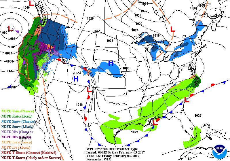
High pressure drifting southeast from the northern High Plains to the Mississippi/Tennessee valleys will push a cold front slowly through Deep South and Southeast this weekend. Gulf moisture will pool along this boundary and help generate rain along the Gulf Coast an up to the Southern Appalachians and Mid-Atlantic. The rain will slowly move to the Western/Central Gulf Coast by Friday into Saturday. To the north, upper-level energy moving over the Great Lakes will aid in producing lake effect snow downwind primarily from the Lakes Superior, Huron and Ontario through Saturday.

An upper-level low over the Eastern Pacific will slowly weaken and move onshore over the Pacific Northwest by Friday evening. The system will bring a plume of moisture into the Central California Coast and into parts of the Northwest into the weekend. Coastal areas will have rain, possibly heavy at times, while areas of higher terrain will have snow. Snow will spread eastward into the Northern Rockies by Friday evening and into the adjacent Northern Plains by Saturday. A secondary low pressure system from the Pacific will advance inland this weekend; which, will bring warmer air into portions of the Northwest. This will allow for the development of rain/freezing rain mix for portions of the Columbia River Gorge and other parts of the Pacific Northwest throughout the day on Friday and into early Saturday. The Sierra Nevadas and ranges from eastern Oregon to northwest Wyoming will likely have heavy snow over the next few days.


LOCAL OVERVIEW

A cold front will move south of the region tonight setting us up for a cooler Friday, and into the weekend, as high pressure settles in. Temperatures rebound to normal and above normal through the middle of next week as southerly flow returns in advance of a moist cold front approaching from the west.


THREE DAY OUTLOOK


National Surface Map for Friday at 7 am

Friday
Partly sunny with highs near 50 and calm winds rising to come out of the northwest 5 to 10 mph in the afternoon. 20% chance of rain, mainly before noon.


Friday Night

Mostly clear with lows near the mid 20s and winds out of the northwest 5 to 10 mph calming before midnight.


National Surface Map for Saturday at 7 am

Saturday

Mostly sunny with highs near the mid to upper 40s and variable light winds.

Saturday Night

Partly cloudy with lows near 30 and light winds out of the southeast.


National Surface Map for Sunday at 7 am

Sunday

Partly sunny with highs near the lower 50s. 20% chance of precipitation, with a wintry mix with no accumulation before 9 am, then rain between 9 am and 3 pm.


Sunday Night

Partly cloudy with lows near the mid 30s.


HAZARDS

No hazardous weather is expected.

As always, you can check to see what advisories, watches and warnings are in effect for Macon County by visiting http://is.gd/MACONWARN


MACON CALENDAR

If you have an event you wish to be added to this calendar, please send the information, along with a flyer of photo, to editor@maconmedia.com
There is no charge for civic, educational or non profit groups.

PRAYERS AGAINST DRUGS

There will be a "Prayers Against Drugs" rally tonight at 6 pm at the Courthouse Square in downtown Franklin for those who are interested in participating in the spiritual warfare against the epidemic of drug abuse in our community. Read more about it at http://thunderpigblog.blogspot.com/2017/01/prayers-against-drugs-rally-scheduled.html


MARDI GRAS DINNER TO BENEFIT REACH OF MACON COUNTY

A Mardi Gras Dinner to benefit REACH of Macon County will be held at Root + Barrel Kitchen on Main Street on Tuesday, February 28th at 6:30 pm.
Reserved tickets are $75 and open seating is $60.
More information is on the flyer posted here.


Weather Extremes Almanac for February 3, 2017


North Carolina

High Temperature 85ºF in Maysville, Onslow County in 1989
Low Temperature -12ºF on Grandfather Mountain, Avery County in 1981
Greatest One-Day Rainfall 5.30 inches in New Holland, Hyde County in 1970
Greatest One-Day Snowfall 18.0 inches on Mount Mitchell, Yancey County in 1998

Macon County

High Temperature 75ºF at the Coweeta Experimental Station in 1989
Low Temperature -12ºF in Highlands in 1917
Greatest One-Day Rainfall 2.91 inches in Franklin in 1982
Greatest One-Day Snowfall 6.0 inches in Highlands in 2013


Astronomy


Twilight Begins: 7:04 am
Sunrise: 7:31 am
Sunset 6:04 pm
Twilight Ends: 6:31 pm
Day Length: 11 hours 27 minutes

Moon Phase: First Quarter with 50% of the visible disk illuminated at 11:19 pm
Moonrise 12:06 am
Moonset 1:11 am tomorrow (no moonset today!)

Observing the Skies

Evening Events and Planets


Chart shows sky at 8:30 pm tonight


Sky Chart for Tonight

Venus and Mars are the bright evening planets.

VENUS
Rises 9:38 am
Sets 9:38 pm
Brightness -4.4 Magnitude
Distance 0.521 AU
Constellation: Pisces

MARS
Rises 9:51 am
Sets 9:59 pm
Brightness 1.1 Magnitude
Distance: 1.867 AU
Constellation: Pisces


Morning Events and Planets

Chart shows sky at 4 am tomorrow morning

Sky Chart for Tomorrow Morning


MERCURY
Rises 6:29 am
Sets 4:17 pm
Brightness 0.0 Magnitude
Distance 1.236 AU
Constellation: Sagittarius

SATURN 


Rises 4:21 am
Sets 2:07 pm
Brightness 1.4 Magnitude
Distance: 10.653 AU
Constellation: Ophiuchus

JUPITER
Rises 11:24 pm
Sets 10: 10:43 am
Brightness -2.0 Magnitude
Distance: 5.011 AU
Constellation: Virgo


Sky Guides for this week (Jan 27- Feb 4)

Sky and Telescope Magazine 
Astronomy Magazine


Earth Sky has an article on the eclipses of 2017. [LINK]

Heavens Above has an Android App that will assist you in observing the sky and even has a satellite tracker that will let you know when the International Space

Station and dozens of other satellites are overhead. [LINK]

Stellarium is also an app that will assist you in observing the sky. It is available in both Android [LINK] and iOS versions. [LINK]


CROWD FUNDING OR DAY SPONSORSHIP OPPORTUNITIES

If you receive value from what Macon Media provides to the community, please consider becoming a supporter and contribute at least a dollar a month.

If you have a business or event you are interested in sponsorship opportunities or underwriting coverage, send an email to editor@MaconMedia.com for more information. Serious inquiries only.

Thank You to the people who have been sending in donations and those businesses who are underwriting coverage of news and events. You have kept Macon Media online.

You have made it possible for Macon Media to begin purchasing state of the art equipment and begin work on building a real website with features not employed by any local news outlets.

You can find out more information on how to do that and some of what I plan to accomplish if I reach certain levels of funding at >> https://www.patreon.com/MaconMedia

Published at 3:06 am on Feb 32017

#WNCscan #MaconWx #MaconSafety


Be kind to one another.


Data and information sources: Sources (except where otherwise credited): heavens-above.com, National Centers for Environmental Prediction, The National Weather Service, National Oceanic Atmospheric Administration, Penn State University Electronic Wall Map, The State Climate Office of North Carolina, Storm Prediction Center, U.S. Naval Observatory, and the Weather Prediction Center.


Thursday, February 2, 2017

Groundhog Day 2017


Today is Candlemas, halfway between the Winter Solstice and the Vernal Equinox. It is also Groundhog Day, the day that folklore holds if it is sunny, then six more weeks of winter are in store, and if cloudy, then spring is nigh.


If Candlemas be fair and bright,
Winter has another flight.
If Candlemas brings clouds and rain,
Winter will not come again.


Scroll down for the prognostications from various groundhogs, nutrias, a squirrel, and even an alligator named Big Al.

For the record, it was cloudy this morning, so...locally, we would be in for an early spring.

via GIPHY
Jimmy the Groundhog bites the Mayor of Sun Prairie, Wisconsin in 2015


Punxsutawney Phil 6 More Weeks
Nibbles (Asheville) Early Spring
Queen Charlotte (Charlotte) Early Spring
Pisgah Pete (White Squirrel) Early Spring
Greta the Groundhog (Chimney Rock) 6 More Weeks
Sunshine and Stormy (NC State Zoo) Early Spring
Chattanooga Chuck Early Spring
General Beauregard Lee Early Spring, Falcons Win
Jimmy the Groundhog 6 More Weeks of Winter
Sir Walter Wally Early Spring
Poor Richard Early Spring
Chuckles Early Spring
Holtsville Hal6 More Weeks
Malverne Mel Early Spring
Staten Island Chuck Early Spring
Dover Doug Early Spring
Octorara Orphie 6 More Weeks
Cocolica Cal Still Hibernating
Dunkirk Dave 6 More Weeks
Buckeye Chuck 6 More Weeks
French Creek Freddie 6 More Weeks
Hutty the Hog 6 More Weeks
Fred la marmotte6 More Weeks
Wiarton Willie Early Spring
Shubenacadie Sam Early Spring
Pierre C. Shadeaux (Nutria) Early Spring
Lawrenceville Lucy 6 More Weeks
Balzac Billy 6 More Weeks
Uni Early Spring
Big Al (Alligator) 6 More Weeks


CROWD FUNDING OR DAY SPONSORSHIP OPPORTUNITIES

If you receive value from what Macon Media provides to the community, please consider becoming a supporter and contribute at least a dollar a month.

If you have a business or event you are interested in sponsorship opportunities or underwriting coverage, send an email to editor@MaconMedia.com for more information. Serious inquiries only.

Thank You to the people who have been sending in donations and those businesses who are underwriting coverage of news and events. You have kept Macon Media online.

You have made it possible for Macon Media to begin purchasing state of the art equipment and begin work on building a real website with features not employed by any local news outlets.

You can find out more information on how to do that and some of what I plan to accomplish if I reach certain levels of funding at Patreon. [LINK]

Daily Weather Briefing for Thursday, February 2, 2017


Weather Advisories and Warnings Across the USA

NATIONAL OUTLOOK

...Heavy snow possible for the Sierras...

...Heavy rain possible for Northern California Coast...

...Lake effect snow downwind from the Great Lakes...

A front extending from the Southeast to the Southern Plains will slowly move southward into the Gulf of Mexico by Friday evening while a portion of the boundary lingers over parts of Florida. Moisture from the Gulf of Mexico will pool along the boundary aiding in the development of rain froM parts of the Lower Mississippi Valley to the Southern Appalachians. The rain will slowly move to the Western/Central Gulf Coast by Friday into Saturday. In addition, the rain will move eastward from the Southern Appalachians to the Southeast/Southern Mid-Atlantic by Friday morning and off the Southeast Coast by Friday evening. Furthermore, upper-level energy moving over the Great Lakes will aid in producing lake effect snow downwind from the Great Lakes through Friday.

Meanwhile, upper-level jet dynamics will aid in producing snow over parts of the Northern Intermountain Region to parts of the Central High Plains through Friday morning. Also, an upper-level low over the Eastern Pacific will slowly weaken and move onshore over the Pacific Northwest by Friday evening. The system will bring a plume of moisture into the Central California Coast and into parts of the Northwest through Friday into Saturday. The Storm will produce coastal rain and higher elevation snow over parts of California and parts of Oregon by Thursday morning. The rain and higher elevation snow will expand into parts of Washington State overnight Thursday. Snow will expand into parts of the Northern Intermountain Region/Northern Rockies on Friday into Saturday. Along with the moisture, warmer air will move into parts of the Northwest that will allow for the development of rain/freezing rain over parts of the Columbia River Gorge and other parts of the Pacific Northwest on Friday into Friday evening.


LOCAL OVERVIEW

A cold front with light precipitation will slide south into the region today. Behind the front, temperatures will drop back below normal for Friday and the weekend as high pressure settles over the region. Temperatures rebound to normal and above normal through the middle of next week as southerly flow returns in advance of a moist cold front approaching from the west.


THREE DAY OUTLOOK


Thursday at 7 am

Thursday
Patchy fog early. Mostly cloudy with highs near the mid to upper 50s and calm winds early, rising to come from the northwest by mid morning. 30% chance of rain with less than a tenth of an inch of drizzle expected.


Thursday Night

Mostly cloudy with lows near the mid to upper 30s and winds out of the northwest calming before midnight.


Friday at 7 am

Friday

Mostly cloudy with highs near the mid to upper 40s. Calm winds rising to come from the northwest in the afternoon hours. 30% chance of rain with less than a tenth of an inch of drizzle expected.

Friday Night

Mostly cloudy with lows near the mid to upper 20s. Winds out of the northwest calming before midnight.


Saturday at 7 am

Saturday

Mostly sunny with highs near the mid 40s.


Saturday Night

Partly cloudy with lows near freezing.


HAZARDS

No hazardous weather is expected.

As always, you can check to see what advisories, watches and warnings are in effect for Macon County by visiting http://is.gd/MACONWARN


MACON CALENDAR

If you have an event you wish to be added to this calendar, please send the information, along with a flyer of photo, to editor@maconmedia.com
There is no charge for civic, educational or non profit groups.

PRAYERS AGAINST DRUGS

There will be a "Prayers Against Drugs" rally on Friday at 6 pm at the Courthouse Square in downtown Franklin for those who are interested in participating in the

spiritual warfare against the epidemic of drug abuse in our community. Read more about it at http://thunderpigblog.blogspot.com/2017/01/prayers-against-drugs-rally-scheduled.html


MARDI GRAS DINNER TO BENEFIT REACH OF MACON COUNTY

A Mardi Gras Dinner to benefit REACH of Macon County will be held at Root + Barrel Kitchen on Main Street on Tuesday, February 28th at 6:30 pm.
Reserved tickets are $75 and open seating is $60.
More information is on the flyer posted here.


Weather Extremes Almanac for February 2, 2017


North Carolina

High Temperature 87ºF in Siler City, Chatham County in 1982
Low Temperature -10ºF on Mount Mitchell, Yancey County in 1980
Greatest One-Day Rainfall 4.68 inches in Brevard, Transylvania County in 1973
Greatest One-Day Snowfall 9.0 inches in Boone, Watauga County in 1958

Macon County

High Temperature 75ºF in Franklin in 1989
Low Temperature -7ºF in Highlands in 1917
Greatest One-Day Rainfall 2.93 inches in Highlands in 1983
Greatest One-Day Snowfall 7.5 inches in Nantahala in 1936


Astronomy


Twilight Begins: 7:05 am
Sunrise: 7:32 am
Sunset 6:03 pm
Twilight Ends: 6:30 pm
Day Length: 11 hours 25 minutes

Moon Phase: Waxing Crescent with 34% of the Moon's visible disk illuminated
Moonrise 11:02 am
Moonset 12:06 am tomorrow (no moonset today!)

Observing the Skies

Evening Events and Planets


Chart shows sky at 8:30 pm tonight


Venus and Mars are the bright evening planets.

VENUS
Rises 9:31 am
Sets 9:38 pm
Brightness -4.4 Magnitude
Distance 0.528 AU
Constellation: Pisces

MARS
Rises 9:53 am
Sets 9:59 pm
Brightness 1.1 Magnitude
Distance: 1.861 AU
Constellation: Pisces


Morning Events and Planets

Chart shows sky at 4 am tomorrow morning


MERCURY
Rises 6:27 am
Sets 4:15 pm
Brightness 0.0 Magnitude
Distance 1.224 AU
Constellation: Sagittarius

SATURN 


Rises 4:25 am
Sets 2:11 pm
Brightness 1.4 Magnitude
Distance: 10.665 AU
Constellation: Ophiuchus

JUPITER
Rises 11:28 pm
Sets 10: 10:47 am
Brightness -2.0 Magnitude
Distance: 5.026 AU
Constellation: Virgo


Sky Guides for this week (Jan 27- Feb 4)

Sky and Telescope Magazine 
Astronomy Magazine


Earth Sky has an article on the eclipses of 2017. [LINK]

Heavens Above has an Android App that will assist you in observing the sky and even has a satellite tracker that will let you know when the International Space Station and dozens of other satellites are overhead. [LINK]

Stellarium is also an app that will assist you in observing the sky. It is available in both Android [LINK] and iOS versions. [LINK]


CROWD FUNDING OR DAY SPONSORSHIP OPPORTUNITIES

If you receive value from what Macon Media provides to the community, please consider becoming a supporter and contribute at least a dollar a month.

If you have a business or event you are interested in sponsorship opportunities or underwriting coverage, send an email to editor@MaconMedia.com for more information. Serious inquiries only.

Thank You to the people who have been sending in donations and those businesses who are underwriting coverage of news and events. You have kept Macon Media online.

You have made it possible for Macon Media to begin purchasing state of the art equipment and begin work on building a real website with features not employed by any local news outlets.

You can find out more information on how to do that and some of what I plan to accomplish if I reach certain levels of funding at >> https://www.patreon.com/MaconMedia

Published at 4:33 am on Feb 2, 2017

#WNCscan #MaconWx #MaconSafety


Be kind to one another.


Data and information sources: Sources (except where otherwise credited): heavens-above.com, National Centers for Environmental Prediction, The National Weather Service, National Oceanic Atmospheric Administration, Penn State University Electronic Wall Map, The State Climate Office of North Carolina, Storm Prediction Center, U.S. Naval Observatory, and the Weather Prediction Center.


Wednesday, February 1, 2017

AT&T Plans to Deploy Broadband Over Powerlines
A Brief History of Local Broadband Discussions

Image CC BY-SA 3.0 NY


Broadband over Power Lines (BPL) is one of the ways that acceptable internet speeds can be delivered to a large chunk of America, especially locations in rural areas where fiber optic to the home or internet via radio towers is not an option for telecommunication companies unwilling or unable to make an investment in their infrastructure. 

Edit with link added from commenter on Facebook: Whether or not they can make it work without causing interference to other users of the radio spectrum is a different question. [LINK]

Digital Trends has an article about BPL that makes for interesting reading. [LINK] It is where the video posted above originated.

BPL could fill in the gap until longer term delivery systems, like orbiting drones, come into play. Even that future is in doubt after Google has dropped it's plan to use drones to deliver internet access to under served locations. [LINK]

Residential access to internet speeds in excess of 25 Mbps down and 3 Mbps up is going to be crucial to economic success in the next few years. 


Definitions

BPL = Broadband over Power Line [LINK]
Mbps = Megabits per second [LINK]

FCC Redefines Broadband [LINK]


Local Broadband Discussions

Access to a faster, and more reliable, internet service has been a topic of discussion for Macon County for a while now. Here are some links to how the discussion has gone in past years, with most recent videos and links first:

Broadband Presentation - December 2016


Broadband Discussion - October 2016


County Planning Board - September 2016


December 2015 Planning Board Meeting


Of course, the current delivery methods used by those who provide internet service is not going to be able to meet the FCC Definition of Broadband access (25 Mbps Up and 3 Mbps down) anytime soon, except in very small geographically confined locations.

Perhaps the biggest barrier to accessing faster internet is the government itself, as can seen seen in a TechDirt article from Jan 2016. [LINK]


I'll leave you with perhaps the granddaddy of the broadband discussions in Macon County, a meeting that took place in December 2011 hosted by MCNC and Advantage West at Southwestern Community College: [LINK]


Commentary and Call to Action

We geared up and won World War Two in less time than the period that has elapsed since the need for higher speed internet has been recognized.


To keep track of national developments in increasing access to broadband, keep an eye on the FCC web page "Measuring Broadband America." [LINK]

In the coming days, the 2017 report should be posted on that page. 

Perhaps the best way to ensure we get faster internet is to keep reminding your elected officials at the local, state and federal levels...and call your internet provider to ask them what they're doing to increase their internet speed.

Contact Details and Links to More Information

Franklin Town Board of Aldermen [LINK]

Macon County Commissioners [LINK]

State Representative [LINK]

State Senator [LINK]

US Congressman [LINK]

US Senators [LINK] 

FCC Consumer Guide to Getting Broadband [LINK]

NC Broadband [LINK]

National Broadband Map [LINK]

National Telecommunications & Information Administration Blog [LINK]

If you have any comments to add, please leave them on our Facebook Page. [LINK]


CROWD FUNDING OR DAY SPONSORSHIP OPPORTUNITIES

If you receive value from what Macon Media provides to the community, please consider becoming a supporter and contribute at least a dollar a month.

If you have a business or event you are interested in sponsorship opportunities or underwriting coverage, send an email to editor@MaconMedia.com for more information. Serious inquiries only.

Thank You to the people who have been sending in donations and those businesses who are underwriting coverage of news and events. You have kept Macon Media online.

You have made it possible for Macon Media to begin purchasing state of the art equipment and begin work on building a real website with features not employed by any local news outlets.

You can find out more information on how to do that and some of what I plan to accomplish if I reach certain levels of funding at >> https://www.patreon.com/MaconMedia


Daily Weather Briefing for Wednesday, February 2, 2017


Weather Advisories and Warnings Across the USA

NATIONAL OUTLOOK

...Rain and mountain snow returns to the western U.S. while the remainder of the nation remains rather uneventful...

After several days of a rather uneventful weather pattern across most of the nation, things will begin changing for the West Coast going into Thursday. The western U.S. ridge is expected to break down some and allow for a Pacific storm system to work its way towards the California coast and bring moderate to heavy rain back to central and northern California, and also Oregon. Parts of the coastal ranges could get 1 to 3 inches of rainfall by Friday morning. Heavy snow is also likely for the higher elevations of the Sierra and also for the northern Rockies.

Elsewhere across the continental U.S., broad cyclonic flow aloft will keep a cool and dry pattern in place for most areas. Lake effect snow is expected downwind of the Great Lakes, where snowfall amounts in excess of six inches are possible. Another area of precipitation in the form of rain is likely across portions of the southern U.S. in association with a surface low developing along a cold front.


LOCAL OVERVIEW

Expect continued warming though Wednesday as southerly flow boosts temperatures to much above normal levels. A dry cold front will slide south into the region by Thursday dropping temperatures back below normal Friday and through the weekend. A low-pressure system and associated cold front will approach from the west at the end of the weekend with light to moderate precipitation.


THREE DAY OUTLOOK


National Surface Map for Wednesday Feb 1st at 7 am

Wednesday

Mostly sunny with highs near the lower 60s and light winds out of the west increasing to 5 to 10 mph by midmorning.


Wednesday Night

Mostly cloudy with lows near 40 and winds out of the west. 30% chance of rain with rainfall amounts of less than a tenth of an inch expected.


National Surface Map for Thursday Feb 2nd

Thursday

Mostly sunny with highs near the mid 50s and winds out of the northwest.

Thursday Night

Mostly cloudy with lows near the mid to upper 30s and winds out of the northwest calming before midnight.


National Surface Map for Friday Feb 3rd at 7 am

Friday

Mostly cloudy with highs near 50. 30% chance of rain, mainly before 4 pm.


Friday Night

Mostly cloudy with lows near freezing.


HAZARDS

No hazardous weather is expected.

As always, you can check to see what advisories, watches and warnings are in effect for Macon County by visiting http://is.gd/MACONWARN


MACON CALENDAR

If you have an event you wish to be added to this calendar, please send the information, along with a flyer of photo, to editor@maconmedia.com
There is no charge for civic, educational or non profit groups.

PRAYERS AGAINST DRUGS

There will be a "Prayers Against Drugs" rally on Friday at 6 pm at the Courthouse Square in downtown Franklin for those who are interested in participating in the spiritual warfare against the epidemic of drug abuse in our community. Read more about it at http://thunderpigblog.blogspot.com/2017/01/prayers-against-drugs-rally-scheduled.html


MARDI GRAS DINNER TO BENEFIT REACH OF MACON COUNTY

A Mardi Gras Dinner to benefit REACH of Macon County will be held at Root + Barrel Kitchen on Main Street on Tuesday, February 28th at 6:30 pm.
Reserved tickets are $75 and open seating is $60.
More information is on the flyer posted here.


Weather Extremes Almanac for February 1, 2017


North Carolina

High Temperature 83ºF in Laurinburg, Scotland County in 2002
Low Temperature -14ºF on Mount Mitchell, Yancey County in 1980
Greatest One-Day Rainfall 4.50 inches in Highlands, Macon County in 1915
Greatest One-Day Snowfall 18.0 inches in Henderson, Vance County in 1948

Macon County

High Temperature 75ºF in Franklin in 1975
Low Temperature -5ºF in Highlands in 1900
Greatest One-Day Rainfall 4.50 inches in Highlands in 1915
Greatest One-Day Snowfall 8.3 inches in Nantahala in 1934


Astronomy


Twilight Begins: 7:06 am
Sunrise: 7:32 am
Sunset 6:02 pm
Twilight Ends: 6:29 pm
Day Length: 11 hours 22 minutes

Moon Phase: Waxing Crescent with 24% of the Moon's visible disk illuminated
Moonrise 10:25 am
Moonset 11:02 pm

Observing the Skies

Evening Events and Planets


Chart shows sky at 8:30 pm

tonight


Evening Sky Chart

Venus and Mars are the bright evening planets.

VENUS
Rises 9:33 am
Sets 9:38 pm
Brightness -4.4 Magnitude
Distance 0.536 AU
Constellation: Pisces

MARS
Rises 9:55 am
Sets 10:00 pm
Brightness 1.1 Magnitude
Distance: 1.854 AU
Constellation: Pisces


Morning Events and Planets

Chart shows sky at 4 am on Wednesday, February 2nd at 4 am

Morning Sky Chart for Feb 2nd


MERCURY
Rises 6:26 am
Sets 4:12 pm
Brightness 0.0 Magnitude
Distance 1.212 AU
Constellation: Sagittarius

SATURN 


Rises 4:29 am
Sets 2:14 pm
Brightness 1.4 Magnitude
Distance: 10.678 AU
Constellation: Ophiuchus

JUPITER
Rises 11:32 pm
Sets 10: 51 am
Brightness -2.0 Magnitude
Distance: 5.041 AU
Constellation: Virgo


Sky Guides for this week (Jan 27- Feb 4)

Sky and Telescope Magazine 
Astronomy Magazine


Earth Sky has an article on the eclipses of 2017. [LINK]

Heavens Above has an Android App that will assist you in observing the sky and even has a satellite tracker that will let you know when the International Space

Station and dozens of other satellites are overhead. [LINK]

Stellarium is also an app that will assist you in observing the sky. It is available in both Android [LINK] and iOS versions. [LINK]


CROWD FUNDING OR DAY SPONSORSHIP OPPORTUNITIES

If you receive value from what Macon Media provides to the community, please consider becoming a supporter and contribute at least a dollar a month.

If you have a business or event you are interested in sponsorship opportunities or underwriting coverage, send an email to editor@MaconMedia.com for more information. Serious inquiries only.

Thank You to the people who have been sending in donations and those businesses who are underwriting coverage of news and events. You have kept Macon Media online.

You have made it possible for Macon Media to begin purchasing state of the art equipment and begin work on building a real website with features not employed by any local news outlets.

You can find out more information on how to do that and some of what I plan to accomplish if I reach certain levels of funding at >> https://www.patreon.com/MaconMedia

Published at 3:48 am on Feb 1, 2017

#WNCscan #MaconWx #MaconSafety


Be kind to one another.


Data and information sources: Sources (except where otherwise credited): heavens-above.com, National Centers for Environmental Prediction, The National Weather Service, National Oceanic Atmospheric Administration, Penn State University Electronic Wall Map, The State Climate Office of North Carolina, Storm Prediction Center, U.S. Naval Observatory, and the Weather Prediction Center.