Notice

I am working on the template of this blog today in order to chase down some problems that have developed with my template and widgets.

Macon County Commissioners

Coverage of the meetings of the Macon County Board of County Commissioners.

Franklin Town Board of Aldermen

Coverage of the meetings of the Franklin Town Board of Aldermen.

Macon County School Board

Coverage of the meetings of the Macon County School Board.

Photoblog

Photos from my photoblog.

nullspace for future use

nullspace for future use

About

Sunday, March 5, 2023

Weather Briefing for Sunday, March 05, 2023

Due to an extended illness, Macon Media will be on light duty and will not be aggregating news links for a little bit. I apologize for any inconvenience this may cause. --Bobby Dry high pressure will continue across the area today through Monday. A dry cold front will arrive on Tuesday, with a second shot of cool air Tuesday night into Wednesday. Moisture and rain chances eventually return mid to late week with the greatest rain chances focused Friday into next weekend as a system moves through the region.

HAZARDOUS WEATHER OUTLOOK

Hazardous weather is not expected today or tonight.


---BEGIN SPONSOR SEGMENT---


Weather Sponsor


Adams Products, a Division of Oldcastle is underwriting the daily weather briefing & public safety updates for the month.

Open 7:30 AM to 4:00 PM, M-F, located at 895 Hickory Knoll Road, Franklin, NC. Visit our Facebook page at: https://www.facebook.com/Adams.Oldcastle.Franklin.NC

All your masonry needs are available. Our phone number is 828.524.8545, the public is welcome, we̢۪ll help you with your next project.


DAY SPONSOR


Macon Media is being underwritten today by Franklin Office Supply. Visit their store at 161 Highlands Road in Franklin or check out their website.


---END SPONSOR SEGMENT------


LOCAL WEATHER OUTLOOK

Franklin Area

Today

Sunny, with highs in the mid 60s. Calm winds in the morning increasing to come out of the south around 5 mph in the afternoon.

Tonight

Mostly clear, with lows in the mid-to-upper 30s. Light winds out of the southeast.

Monday

Sunny, with highs near 70. Calm winds early in the morning increasing to come out of the southwest 5 to 10 mph by midmorning.

Monday Night

Partly cloudy, with lows around 50. Winds out of the southwest 5 to 10 mph shifting to come out of the northwest after midnight.

Tuesday

Mostly sunny, with highs near 70.

Tuesday Night

Mostly clear, with lows in the mid-to-upper 30s.

Highlands Plateau

Today

Sunny, with highs in the mid-to-upper 50s. Calm winds in the morning increasing to come out of the southeast around 5 mph in the afternoon.

Tonight

Mostly clear, with lows around 40. Winds out of the southeast around 5 mph.

Monday

Mostly sunny, with highs near 60. Winds out of the southwest 5 to 10 mph.

Monday Night

Partly cloudy, with lows around 50. Winds out of the southwest 10 to 20 mph shifting to come out of the northwest after midnight. Winds could gust as high as 30 mph.

Tuesday

Mostly sunny, with highs in the mid 60s. Windy.

Tuesday Night

Mostly clear, with lows in the upper 30s. Windy.

Otto and South Central Macon County

Today

Sunny, with highs in the mid 60s. Calm winds in the morning increasing to come out of the south 5 to 10 mph in the afternoon.

Tonight

Mostly clear, with lows around 40. Winds out of the southeast around 5 mph becoming calm before midnight.

Monday

Sunny, with highs in the upper 60s. Light winds out of the southeast shifting to come out of the southwest 5 to 10 mph by midmorning.

Monday Night

Partly cloudy, with lows in the lower 50s. Winds out of the southwest 5 to 15 mph shifting to come out of the northwest after midnight. Winds could gust as high as 20 mph.

Tuesday

Mostly sunny, with highs near 70.

Tuesday Night

Mostly clear, with lows in the upper 30s.


Nantahala Area

Today

Sunny, with highs in the low-to-mid 60s. Light winds out of the southeast.

Tonight

Mostly clear, with lows around 40. Light winds out of the southeast.

Monday

Sunny, with highs in the mid 60s. Calm winds early in the morning increasing to come out of the southwest 5 to 10 mph by midmorning.

Monday Night

A 20 percent chance of showers after 3am. Partly cloudy, with lows in the lower 50s. Winds out of the southwest 5 to 10 mph shifting to come out of the west after midnight.

Tuesday

Mostly sunny, with highs in the mid 60s.

Tuesday Night

Mostly clear, with lows in the mid-to-upper 30s.


Support Macon Media

If you receive value from what Macon Media provides to the community, please consider becoming a supporter and contribute at least a dollar a month. Those who support Macon Media with at least a dollar a month receive early access to video of some events and meetings before they are made public on the website. Videos and news involving public safety are not subject to early access.


Become a Patron!


Or, if you prefer Pay Pal, try PayPal.me/MaconMedia


Published at 5:00am on Sunday, March 05, 2023
Author: Bobby Coggins


Saturday, March 4, 2023

Weather Briefing for Saturday, March 04, 2023


Due to an extended illness, Macon Media will be on light duty and will not be aggregating news links for a little bit. I apologize for any inconvenience this may cause. --Bobby

Dry high pressure will build into the area from the west over the weekend and linger into the early part of next week. Another cold front will arrive Tuesday, before stalling south of the area through the middle of next week.

A severe weather event took place yesterday afternoon and a liveblog was created to mirror content posted in real-time on Facebook by Macon Media and members of the community. [LINK]

TODAY

Chili Cook-Off at the community building 2 to 4pm

$5 entry fee to come in and taste the chili and vote for your favorite. All proceeds go to helping a child go to gymnastics camp this summer with her teammates. Contact sgors.sg@gmail.com for more information.


HAZARDOUS WEATHER OUTLOOK

Hazardous weather is not expected today or tonight.


---BEGIN SPONSOR SEGMENT---


Weather Sponsor


Adams Products, a Division of Oldcastle is underwriting the daily weather briefing & public safety updates for the month.

Open 7:30 AM to 4:00 PM, M-F, located at 895 Hickory Knoll Road, Franklin, NC. Visit our Facebook page at: https://www.facebook.com/Adams.Oldcastle.Franklin.NC

All your masonry needs are available. Our phone number is 828.524.8545, the public is welcome, we̢۪ll help you with your next project.


---END SPONSOR SEGMENT------


LOCAL WEATHER OUTLOOK

Franklin Area

Today

Sunny, with highs in the low-to-mid 60s. Winds out of the northwest 5 to 10 mph.

Tonight

Clear, with lows in the mid 30s. Winds out of the northwest around 5 mph becoming calm before midnight.

Sunday

Sunny, with highs in the mid 60s. Calm winds in the morning increasing to come out of the south 5 to 10 mph in the afternoon.

Sunday Night

Mostly clear, with lows in the upper 30s. Winds out of the south 5 to 10 mph becoming calm before midnight.

Monday

Sunny, with highs near 70.

Monday Night

Partly cloudy, with lows around 50.

Highlands Plateau

Today

Sunny, with highs in the upper 50s. Winds out of the northwest 15 to 20 mph in the morning decreasing to 5 to 10 mph in the afternoon. Winds could gust as high as 40 mph in the early morning hours.

Tonight

Clear, with lows in the mid 30s. Winds out of the northwest 5 to 10 mph.

Sunday

Sunny, with highs in the mid-to-upper 50s. Winds out of the north 5 to 10 mph shifting to come out of the south by midmorning.

Sunday Night

Mostly clear, with lows in the upper 30s. Winds out of the south 5 to 10 mph shifting to come out of the east after midnight.

Monday

Mostly sunny, with highs near 60.

Monday Night

Partly cloudy, with lows around 50.

Otto and South Central Macon County

Today

Sunny, with highs in the low-to-mid 60s. Winds out of the northwest 5 to 10 mph, with gusts as high as 20 mph.

Tonight

Clear, with lows in the mid 30s. Winds out of the north around 5 mph becoming calm before midnight.

Sunday

Sunny, with highs in the mid 60s. Calm winds in the morning increasing to come out of the south 5 to 10 mph in the afternoon.

Sunday Night

Mostly clear, with lows around 40. Winds out of the southeast 5 to 10 mph.

Monday

Sunny, with highs in the upper 60s.

Monday Night

Partly cloudy, with lows in the lower 50s.


Nantahala Area

Today

Sunny, with highs in the mid-to-upper 50s. Winds out of teh northwest 5 to 10 mph.

Tonight

Clear, with lows in the mid 30s. Winds out of the northwest around 5 mph becoming calm before midnight.

Sunday

Sunny, with highs in the low-to-mid 60s. Calm winds in the morning increasing to come out of the southeast around 5 mph in the afternoon.

Sunday Night

Mostly clear, with lows around 40. Winds out of the southeast 3 to 6 mph.

Monday

Sunny, with highs in the mid 60s.

Monday Night

Partly cloudy, with lows in the lower 50s.


Support Macon Media

If you receive value from what Macon Media provides to the community, please consider becoming a supporter and contribute at least a dollar a month. Those who support Macon Media with at least a dollar a month receive early access to video of some events and meetings before they are made public on the website. Videos and news involving public safety are not subject to early access.


Become a Patron!


Or, if you prefer Pay Pal, try PayPal.me/MaconMedia


Published at 5:00am on Saturday, March 04, 2023
Author: Bobby Coggins


Friday, March 3, 2023

LIVEBLOG: Severe Weather Event on Friday, March 3rd, 2023


OPEN THREAD - SEVERE WEATHER
Friday, March 03, 2023
2:00pm

Skip to updates, which will be posted in reverse chronological order [STORM UPDATES]
A strong cold front that has produced a line of severe storms are approaching Macon County from the west. The line is accompanied by high wind gusts that are often exceeding 60 mph and torrential rainfall exceeding 4 inches per hour. Expect multiple power outages this afternoon when the storms pass through sometime between 3pm and 6pm.

Please use caution and stay off the roads while this line of storms passes and give the NCDOT, Duke Energy, the Town of Franklin and Highlands Work Crews, and Haywood EMC time to restore service. Unless it is to escape hazardous conditions, please consider staying put tonight. Roadways will likely be filled with limbs, powerlines and other debris. If you see a wire down in the roadway or elsewhere, please do not attempt to move it. Call 911 to report it. Do not touch a power line or anything in contact with it, and keep others away until help arrives.

Use the comments in this thread to keep one another updated on conditions in your area or to ask about conditions. Please be kind to one another.

Duke Energy Customers

Report your outage by texting OUT to 57801, report online or call 800.POWERON (800.769.3766)

Haywood EMC Customers call 828-452-2281 or toll-free at 1-800-951-6088 to report an outage at 828-452-2281 or toll-free at 1-800-951-6088

WEATHER SPONSOR 
Adams, an Old Castle Company http://facebook.com/Adams.Oldcastle.Franklin.NC

DAY SPONSOR 
Franklin Office Supply 
FranklinOfficeSupply.com

STORM SPONSOR 
Young Tree Service 
 YoungTreeService.com 828-421-0967


A mirror of this post is on Facebook via the embed below:


STORM UPDATES


4.40am on Saturday

Real-time coverage of this event has been concluded. When the legacy media outlets post stories online about this event, links to their articles will be added. --Bobby

******************
3.20am [Facebook]

POWER OUTAGE REPORT
03-04-2023
3.20am

MACON 
Active Outages...83
Customers Without Power...2208
Estimated Time of Restoration...Assessment underway

JACKSON 
Active Outages...51
Customers Without Power...751
Estimated Time of Restoration...Assessment underway

SWAIN
Active Outages...7
Customers Without Power...266
Estimated Time of Restoration...Assessment underway

DUKE ENERGY 
Active Power Outages:507
Total Customers Without Power:10,936
NC - Customers Without Power:10,091
SC - Customers Without Power:845

HAYWOOD EMC
0 Customers in Macon County
176 out in Haywood County
21 in Jackson County
Active Power Outages:27
Total Customers Without Power:203

*********************
6.50pm [Facebook]

OPEN THREAD - SEVERE WEATHER AFTERMATH THREAD
Friday, March 03, 2023
6.50pm

I am not feeling well and will be unable to continue covering this storm and its aftermath, so here is another open thread for you guys and gals to keep each other in the loop as to what you are seeing and hearing.

A strong cold front produced a line of severe storms that swept thrpugh Macpon County this afternoon. The line was accompanied by high wind gusts,torrential rainfall, hail, and lightning. Expect multiple power outages this afternoon when the storms pass through sometime between 3pm and 6pm.

Please use caution and stay off the roads while this line of storms passes and give the NCDOT, Duke Energy, the Town of Franklin and Highlands Work Crews, and Haywood EMC time to restore service. Unless it is to escape hazardous conditions, please consider staying put tonight. Roadways will likely be filled with limbs, powerlines and other debris. If you see a wire down in the roadway or elsewhere, please do not attempt to move it. Call 911 to report it. Do not touch a power line or anything in contact with it, and keep others away until help arrives.

Use the comments in this thread to keep one another updated on conditions in your area or to ask about conditions. Please be kind to one another. 

STORM SPONSOR
Young Tree Service
YoungTreeService.com

Duke Energy Customers
Report your outage by texting OUT to 57801, report online or call 800.POWERON (800.769.3766)

Haywood EMC Customers call 828-452-2281 or toll-free at 1-800-951-6088 to report an outage.
at 828-452-2281 or toll-free at 1-800-951-6088

POWER OUTAGE REPORT
03-03-2023
5.00pm

MACON 
Active Outages...94
Customers Without Power...6656
Estimated Time of Restoration...Assessment underway

JACKSON 
Active Outages...70
Customers Without Power...1602
Estimated Time of Restoration...Assessment underway

SWAIN
Active Outages...11
Customers Without Power...157
Estimated Time of Restoration...Assessment underway

DUKE ENERGY 
Active Power Outages:494
Total Customers Without Power:16,358
NC - Customers Without Power:15,889
SC - Customers Without Power:469

HAYWOOD EMC
352 Customers in Macon County
1089 out in Haywood County
896 in Jackson County
Active Power Outages:42
Total Customers Without Power:2463

*********************
6.42pm [Facebook]

A tree is reported to be down near 800 Teague Road. It is in a difficult-to-see position. Clarks Chapel VFD is responding.
Please use caution in the area for the next couple of hours or so.

****************
6.39pm [Facebook]

Two simultaneous calls 

Call 1 
There is a report of a tree down on a powerline near 400 Noah Gison Road. The powerline is sparking. Franklin VFD is responding.
Please use caution in the area for the next couple of hours or so.

Call 2
A tree is down on some powerlines and sparks are present near 200 Deal Road. Franklin VFD is responding.

***********************
6.16pm [Facebook]

Tree down on a car near 1350 Clarks Chapel Road. The entire roadway is blocked. This is near the intersection with Dowdle Mountain Road. No injuries.
Clarks Chapel VFD is responding.

Please reroute around this location for the next hour or two.

*********************
5.23pm

CORRECTION. The rain is over. The wind is still blowing and a Wind Advisory will be in effect until 7am in the morning, We are not out of the woods yet.

*****************


5.06pm

The storm is almost over. The line is just to the east of Franklin stretching from the southwest to the northeast. Only the Highlands Plateau has severe weather remaining. It should be past in ten minutes or so for those in that area.


***********************
POWER OUTAGE REPORT
03-03-2023
5.00pm

MACON 

Active Outages...95
Customers Without Power...5794
Estimated Time of Restoration...Assessment underway

JACKSON 

Active Outages...44
Customers Without Power...579
Estimated Time of Restoration...Assessment underway

SWAIN

Active Outages...15
Customers Without Power...757
Estimated Time of Restoration...Assessment underway

DUKE ENERGY 
Active Power Outages:455
Total Customers Without Power:17,836
NC - Customers Without Power:12,621
SC - Customers Without Power:5,215

HAYWOOD EMC
233 Customers in Macon County
250 out in Haywood County
729 in Jackson County
Active Power Outages:13
Total Customers Without Power:2064

**************************
4.55pm

A reader reported (at 4.26pm) a large tree down on Fulton Road. The road was blocked.

**********
4.51PM


BULLETIN - IMMEDIATE BROADCAST REQUESTED 
Severe Thunderstorm Warning 
National Weather Service Greenville-Spartanburg SC 
418 PM EST Fri Mar 3 2023

The National Weather Service in Greenville-Spartanburg has issued a

* Severe Thunderstorm Warning for... Habersham County in northeastern Georgia... Rabun County in northeastern Georgia...

* Until 515 PM EST.

* At 417 PM EST, severe thunderstorms were located along a line extending from 3 miles northwest of Hiawassee to 11 miles north of Dahlonega to 6 miles west of Dawsonville, moving east at 40 mph.

 HAZARD...60 mph wind gusts.

 SOURCE...Radar indicated.

 IMPACT...Expect damage to trees and power lines.

* Locations impacted include... Clayton, Clarkesville, Cornelia, Baldwin, Demorest, Alto, Mountain City, Tiger, Dillard and Sky Valley.

PRECAUTIONARY/PREPAREDNESS ACTIONS...

A Tornado Watch remains in effect until 800 PM EST for northeastern Georgia...western North Carolina...and Upstate South Carolina.

Remain alert for a possible tornado! Tornadoes can develop quickly from severe thunderstorms. If you spot a tornado go at once into the basement or small central room in a sturdy structure.

A few trees and power lines will be blown down in the warned area. Storms will be accompanied by brief heavy rainfall, and little or no lightning. Seek shelter inside an interior room.

Please report damaging winds, hail, or flooding to the National Weather Service by calling toll free, 1, 800, 2 6 7, 8 1 0 1, or by posting on our Facebook page, or Tweet it using hashtag nwsgsp. Your message should describe the event and the specific location where it occurred.


***************************
4.40pm 

There is a report of a tree on a vehicle near 1200 Walnut Creek Road. A firefighter is on the scene and requesting assistance with traffic control. Cullasaja-Gorge VFD is responding


Photo ©2023 by Ellen Agee and used with permission.


*********************
4.39pm

Here is a look at that last cluster of lightning strikes!


*****************************
4.35pm 

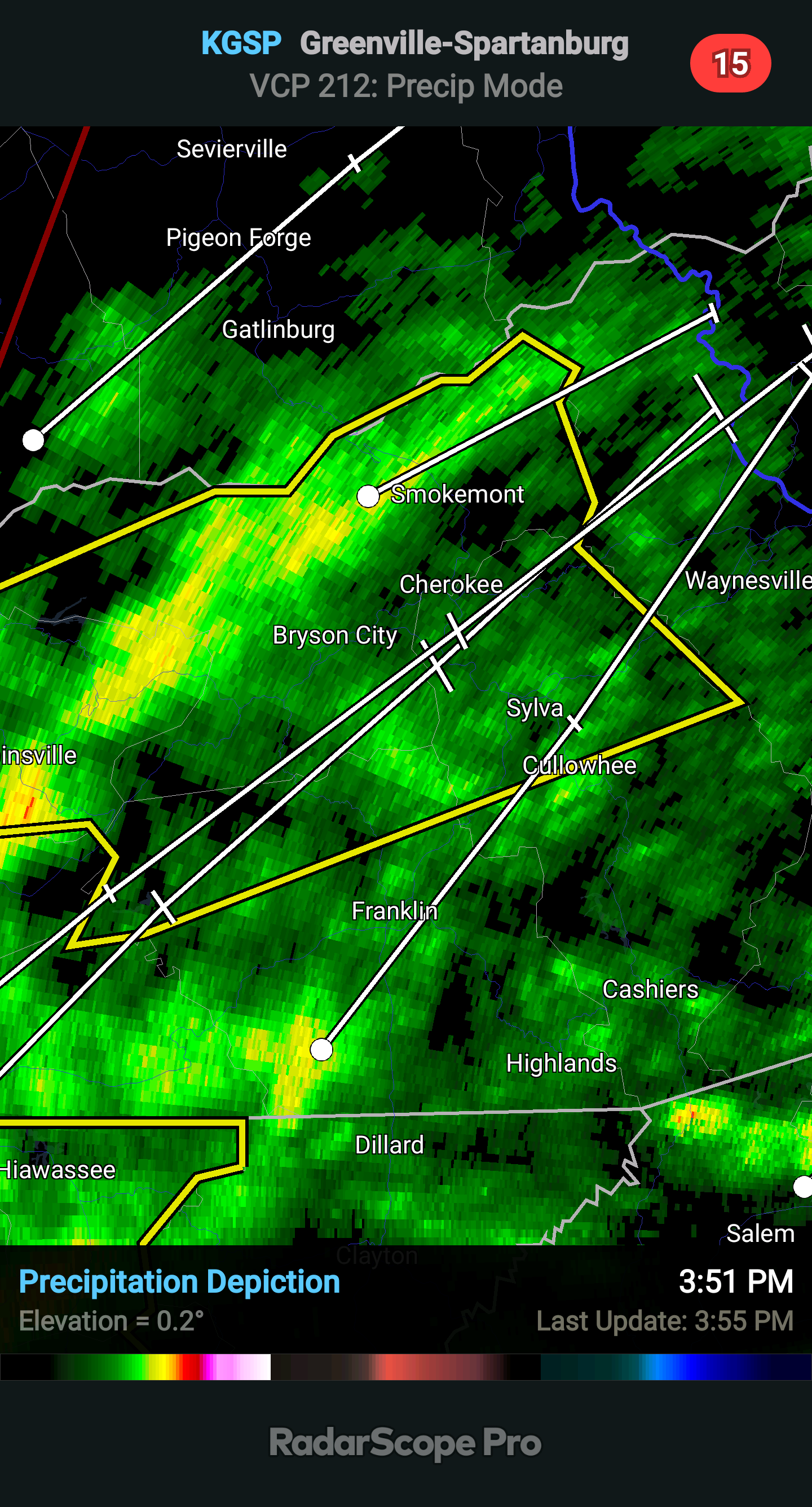
An area of intense rain and heavy winds is about to come into Macon County from the southwest. Rain is falling at a rate of over 4 inches in this cell and it is moving to the northeast at 106 knots (121 mph). Winds are gusting up to 70 mph in this region, so please stay inside and seek shelter in the most sturdy portion of your home. Hail up to half an inch is also associated with this cell.


*************
4.26pm Readers have been reporting a tree down and waterline break at Yonder. Here is the post:
 

*************************
3.57pm

Some of these storm cells are traveling over 100 mph.

This one in southwest Macon County is traveling from the southwest to the northeast at 89 knots, or 102.419mph!!!


**********************
3.46pm

Most of the outages in Macon County are on the Highlands Plateau near Highlands and Cashiers. Over 6,000 Duke Energy and Haywood EMC customers are without electrical service right now.

*********************
POWER OUTAGE REPORT
03-03-2023
3.40pm

MACON 

Active Outages...28
Customers Without Power...2907
Estimated Time of Restoration...Assessment underway

JACKSON 

Active Outages...12
Customers Without Power...4339
Estimated Time of Restoration...Assessment underway

SWAIN

Active Outages...7
Customers Without Power...389
Estimated Time of Restoration...Assessment underway

DUKE ENERGY 
Active Power Outages:152
Total Customers Without Power:15,516
NC - Customers Without Power:10,357
SC - Customers Without Power:5,159

HAYWOOD EMC
69 Customers in Macon County
1115 out in Haywood County
874 in Jackson County
Active Power Outages:12
Total Customers Without Power:1785


*****************************

3.40pm

Live Transformer in the Roadway near Pete McCoy Road and Clarks Chapel Road. Clarks Chapel VFD responding.

If you're crazy enough to be out and about in this storm, avoid this location for the next several hours. 


*********************************

URGENT - IMMEDIATE BROADCAST REQUESTED 
Tornado Watch Number 63 
NWS Storm Prediction Center Norman OK 
240 PM EST Fri Mar 3 2023

 The NWS Storm Prediction Center has issued a

 * Tornado Watch for portions of North Georgia Western North Carolina Western South Carolina Eastern Tennessee Far southwest Virginia

 * Effective this Friday afternoon and evening from 240 PM until 800 PM EST.

 * Primary threats include... A few tornadoes and a couple intense tornadoes possible Scattered damaging winds likely with isolated significant gusts to 75 mph possible

 SUMMARY...A long-lived QLCS should continue to progress rapidly east across the southern Appalachians vicinity through early evening. Damaging winds and embedded tornadoes will be possible.

 The tornado watch area is approximately along and 60 statute miles east and west of a line from 35 miles north northeast of Bristol TN to 30 miles southwest of Athens GA. For a complete depiction of the watch see the associated watch outline update (WOUS64 KWNS WOU3).

 PRECAUTIONARY/PREPAREDNESS ACTIONS...

 REMEMBER...A Tornado Watch means conditions are favorable for tornadoes and severe thunderstorms in and close to the watch area. Persons in these areas should be on the lookout for threatening weather conditions and listen for later statements and possible warnings.


3.03pm A Tornado Watch for Macon County has been issued. Will update with details.


***************************
POWER OUTAGE REPORT
03-03-2023
2.50pm

MACON 

Active Outages...11
Customers Without Power...2843
Estimated Time of Restoration...Assessment underway

JACKSON 

Active Outages...6
Customers Without Power...4327
Estimated Time of Restoration...Assessment underway

MACON 

Active Outages...63
Customers Without Power...260
Estimated Time of Restoration...Assessment underway

DUKE ENERGY 
Active Power Outages:131
Total Customers Without Power:13,990
NC - Customers Without Power:8,393
SC - Customers Without Power:5,597

HAYWOOD EMC
7 Customers in Macon County
1039 out in Haywood County
Active Power Outages:6
Total Customers Without Power:1060


***************
2.27pm 


over 200,000 in Tennessee are currently without electrical service after the line of storms has passed through 


2.15pm The Storm Prediction Center in Norman, Oklahoma has posted an alert that conditions are probably going to require a Tornado Watch for the area included inside the red area on the above map. The full text of the advisory is posted below:

Mesoscale Discussion 0247
NWS Storm Prediction Center Norman OK
0112 PM CST Fri Mar 03 2023
Areas affected...Eastern Tennessee into parts of northern Georgia
Concerning...Severe potential...Tornado Watch likely
Valid 031912Z - 032045Z
Probability of Watch Issuance...80 percent
SUMMARY...An additional watch will likely be needed for parts of eastern Tennessee and northern Georgia. Despite weaker thermodynamics, strong, veering low-level winds will support a risk for damaging winds and brief tornadoes.
DISCUSSION...A fast moving line of storms will continue eastward through Middle Tennessee and northern Alabama. Strong wind fields continue to be sampled by regional VAD data. Some cloud cover has kept temperatures a bit subdued, particularly in north Georgia. Parts of eastern Tennessee have warmed into the mid 70s F. Between cooler temperatures, decreased moisture, and warmer temperatures aloft (especially with southward extent), the overall thermodynamic environment will likely be weaker than areas to the west. However, storm motion in addition to 50-70 kts within the boundary layer would support a threat for damaging winds even with relatively weak updrafts. Strong low-level shear would also promote some risk for brief tornadoes within the line of storms. A watch for parts of this region will likely be needed this afternoon.


#WNCnews #MaconSafety #MaconWx

Weather Briefing for Friday, March 03, 2023


Due to an extended illness, Macon Media will be on light duty and will not be aggregating news links for a little bit. I apologize for any inconvenience this may cause. --Bobby

Areas of low pressure will cross Tennessee and the mountains today bringing widespread showers and some storms. Low pressure will organize over Texas and then move northeast through Friday as its cold front approaches our region from the west. There is the potential for severe weather on Friday ahead of this cold front. As the storm system moves over the Atlantic Friday night, dry high pressure moves in for the weekend and the first part of next week.

Saturday March 4th

Chili Cook Off at the community building 2 to 4pm

$5 entry fee to come in and taste chili and vote for your favorite. All proceeds go to helping a child go to gymnastics camp this summer with her team mates. Contact sgors.sg@gmail.com for more information.


HAZARDOUS WEATHER OUTLOOK

A Wind Advisory will be in effect for Macon County from 1pm today through 7am Saturday. We may also come under Severe Thunderstorms Wathes or Warnings as a storm system is expected to pass through the county this afternoon. Conditions will be sufficient for development of scattered strong to severe thunderstorms, which will move quickly across the county from west to east. Damaging winds appear to be the primary threat with these thunderstorms, with a secondary threat of tornadoes, which most likely would be short-lived. The severe weather threat will taper off Friday evening.

WIND ADVISORY

...WIND ADVISORY REMAINS IN EFFECT FROM 1 PM FRIDAY TO 7 AM EST SATURDAY...

* WHAT...Southwest winds 25 to 35 mph with gusts up to 55 mph expected.

* WHERE...The mountains of North Carolina.

* WHEN...From 1 PM Friday to 7 AM EST Saturday.

* IMPACTS...Gusty winds could blow around unsecured objects. Tree limbs could be blown down and a few power outages may result. Travel may be difficult, especially for high profile vehicles.

PRECAUTIONARY/PREPAREDNESS ACTIONS...

Use extra caution when driving, especially if operating a high profile vehicle. Secure outdoor objects.


---BEGIN SPONSOR SEGMENT---


Weather Sponsor


Adams Products, a Division of Oldcastle is underwriting the daily weather briefing & public safety updates for the month.

Open 7:30 AM to 4:00 PM, M-F, located at 895 Hickory Knoll Road, Franklin, NC. Visit our Facebook page at: https://www.facebook.com/Adams.Oldcastle.Franklin.NC

All your masonry needs are available. Our phone number is 828.524.8545, the public is welcome, we̢۪ll help you with your next project.


DAY SPONSOR


Macon Media is being underwritten today by Franklin Office Supply. Visit their store at 161 Highlands Road in Franklin or check out their website.


---END SPONSOR SEGMENT------


LOCAL WEATHER OUTLOOK

Franklin Area

Today

Showers, with thunderstorms also possible after 2pm. Patchy fog before noon. Highs in the upper 60s. Winds out of the southeast 10 to 15 mph in the morning increasing to 15 to 25 mph in the afternoon. Winds could gust as high as 40 mph. Chance of rain is 80%. New rainfall amounts between a quarter and half of an inch possible.

Tonight

A 30 percent chance of showers, mainly before 7pm. Mostly cloudy, with lows around 40. Winds out of the southwest 10 to 20 mph shifting to come out of the northwest after midnight. Winds could gust as high as 35 mph. New rainfall amounts of less than a tenth of an inch possible.

Saturday

Partly sunny, then gradually becoming sunny, with highs in the lower 60s. Winds out of the northwest 10 to 15 mph, with gusts as high as 25 mph.

Saturday Night

Clear, with lows in the mid 30s. Winds out of the north 3 to 8 mph.

Sunday

Sunny, with highs in the mid 60s.

Sunday Night

Mostly clear, with lows in the upper 30s.

Highlands Plateau

Today

Showers, with thunderstorms also possible after 2pm. Some of the storms could produce heavy rainfall. Areas of fog. Highs near 60. Winds out of the southeast 15 to 20 mph in the morning increasing to 25 to 30 mph in the afternoon. Winds could gust as high as 45 mph. Chance of rain is 100%. New rainfall amounts between 1 and 2 inches possible.

Tonight

A chance of showers and thunderstorms before 8pm, then a slight chance of showers. Some of the storms could produce heavy rainfall. Mostly cloudy, with lows in the mid-to-upper 30s. Windy, with a west southwest wind 25 to 29 mph becoming northwest after midnight. Winds could gust as high as 45 mph. Chance of rain is 30%. New rainfall amounts between a tenth and quarter of an inch, except higher amounts possible in thunderstorms.

Saturday

Partly sunny, then gradually becoming sunny, with highs in the mid-to-upper 50s. Winds out of the northwest 15 to 25 mph, with gusts as high as 40 mph.

Saturday Night

Clear, with lows in the mid 30s. Winds out of the northwest 10 to 15 mph, with gusts as high as 20 mph.

Sunday

Sunny, with highs in the upper 50s.

Sunday Night

Mostly clear, with lows in the upper 30s.

Otto and South Central Macon County

Today

Showers, with thunderstorms also possible after 2pm. Some of the storms could produce heavy rainfall. Patchy fog before 1pm. Highs in the mid 60s. Winds out of the southeast 10 to 15 mph in the morning increasing to 15 to 25 mph in the afternoon. Winds could gust as high as 40 mph. Chance of rain is 90%. New rainfall amounts between a half and three quarters of an inch possible.

Tonight

A 30 percent chance of showers, mainly before 7pm. The rain could be heavy at times. Mostly cloudy, with lows around 40. WInds out of the southwest 15 to 20 mph shifting to come out of the northwest after midnight. Winds could gust as high as 40 mph. New rainfall amounts between a tenth and quarter of an inch possible.

Saturday

Partly sunny, then gradually becoming sunny, with highs in the lower 60s. Winds out of the northwest 10 to 15 mph, with gusts as high as 25 mph.

Saturday Night

Clear, with lows in the mid 30s. Winds out of the north 5 to 10 mph.

Sunday

Sunny, with highs in the mid 60s.

Sunday Night

Mostly clear, with lows around 40.


Nantahala Area

Today

Showers likely, then showers and possibly a thunderstorm after 2pm. Patchy fog between 8am and 10am. Highs in the mid 60s. Winds out of the south 10 to 15 mph in the morning increasing to 25 to 30 mph in the afternoon. Winds could gust as high as 50 mph. Chance of rain is 80%. New rainfall amounts between a tenth and quarter of an inch, except higher amounts possible in thunderstorms.

Tonight


A 30 percent chance of showers, mainly before 7pm. Mostly cloudy, with lows around 40. Winds out of the southwest 20 to 25 mph decreasing to 15 to 20 mph after midnight. Winds could gust as high as 40 mph. New rainfall amounts of less than a tenth of an inch possible.

Saturday

Partly sunny, then gradually becoming sunny, with highs in the mid 50s. Winds out of the northwest 5 to 10 mph, with gusts as high as 20 mph.

Saturday Night

Clear, with lows in the mid 30s. Winds out of the north 3 to 7 mph.

Sunday

Sunny, with highs in the low-to-mid 30s.

Sunday Night

Mostly clear, with lows around 40.


Support Macon Media

If you receive value from what Macon Media provides to the community, please consider becoming a supporter and contribute at least a dollar a month. Those who support Macon Media with at least a dollar a month receive early access to video of some events and meetings before they are made public on the website. Videos and news involving public safety are not subject to early access.


Become a Patron!


Or, if you prefer Pay Pal, try PayPal.me/MaconMedia


Published at 5:00am on Friday, March 03, 2023
Author: Bobby Coggins


Thursday, March 2, 2023

Weather Briefing for Thursday, March 02, 2023


Due to an extended illness, Macon Media will be on light duty and will not be aggregating news links for a little bit. I apologize for any inconvenience this may cause. --Bobby Areas of low pressure will cross Tennessee and the mountains today bringing widespread showers and some storms. Low pressure will organize over Texas and then move northeast through Friday as its cold front approaches our region from the west. There is the potential for severe weather on Friday ahead of this cold front. As the storm system moves over the Atlantic Friday night, dry high pressure moves in for the weekend and the first part of next week.

Saturday March 4th

Chili Cook Off at the community building 2 to 4pm

$5 entry fee to come in and taste chili and vote for your favorite. All proceeds go to helping a child go to gymnastics camp this summer with her team mates. Contact sgors.sg@gmail.com for more information.


HAZARDOUS WEATHER OUTLOOK

Widespread rain showers will go on intermittently today and tonight, with the potential for some embedded thunder this afternoon. On Friday, a strong cold front is expected to move quickly across the forecast area, most likely arriving in early- to mid-afternoon. Instability and shear parameters are expected to support scattered strong to severe thunderstorms, with damaging winds and possibly a few tornadoes possible the most likely impacts, though hail will be possible as well. Mid- to late-afternoon looks to be the most likely window for severe threats, but some uncertainty still remains in timing.


---BEGIN SPONSOR SEGMENT---


Weather Sponsor


Adams Products, a Division of Oldcastle is underwriting the daily weather briefing & public safety updates for the month.

Open 7:30 AM to 4:00 PM, M-F, located at 895 Hickory Knoll Road, Franklin, NC. Visit our Facebook page at: https://www.facebook.com/Adams.Oldcastle.Franklin.NC

All your masonry needs are available. Our phone number is 828.524.8545, the public is welcome, we̢۪ll help you with your next project.


DAY SPONSOR

Macon Media is being underwritten today by Franklin Health and Fitness, home of #ResultsForEveryone. Try FHF with a FREE 3-Day Guest Pass! To claim your pass, and to learn more about Franklin Health and Fitness, visit franklinhealthandfitness.com.

-->
---END SPONSOR SEGMENT------


LOCAL WEATHER OUTLOOK

Franklin Area

Today

Showers likely, with thunderstorms also possible after 4pm. Cloudy, with highs in the mid 60s. Winds out of the northwest 5 to 10 mph. Chance of rain is 60%. New rainfall amounts between a tenth and quarter of an inch, except higher amounts possible in thunderstorms.

Tonight

Showers likely and possibly a thunderstorm, then showers after 8pm. Patchy fog after 11pm. Lows in the mid 50s. Light and variable winds increasing to come out of the southeast 5 to 10 mph after midnight. Chance of rain is 90%. New rainfall amounts between a tenth and quarter of an inch, except higher amounts possible in thunderstorms.

Friday

Showers, with thunderstorms also possible after 2pm. Highs in the mid-to-upper 60s. Windy, with a Winds out of the southeast 20 to 25 mph increasing to 25 to 35 mph in the afternoon. Winds could gust as high as 50 mph. Chance of rain is 100%. New rainfall amounts between a quarter and half of an inch possible.

Friday Night

Showers likely before 7pm. Partly cloudy, with lows around 40. Winds out of the southwest 15 to 25 mph shifting to come out of the northwest after midnight. Winds could gust as high as 40 mph. Chance of rain is 60%.

Saturday

Sunny, with highs in the lower 60s.

Saturday Night

Clear, with lows in the mid 30s.

Highlands Plateau

Today

Showers likely, with thunderstorms also possible after 4pm. Mostly cloudy, with highs near 60. Winds out of the northwest 10 to 20 mph in the morning increasing and shifting to come out of the west in the afternoon. Winds could gust as high as 25 mph. Chance of rain is 70%. New rainfall amounts between a tenth and quarter of an inch, except higher amounts possible in thunderstorms.

Tonight

Showers likely and possibly a thunderstorm, then showers after 8pm. Patchy fog after 10pm. Lows in the lower 50s. Winds out of the northwest 5 to 10 mph shifting to come out of the southeast after midnight. Winds could gust as high as 20 mph. Chance of rain is 100%. New rainfall amounts between a quarter and half of an inch possible.

Friday

Showers, with thunderstorms also possible after 2pm. Some of the storms could produce heavy rainfall. Highs near 60. Winds out of the south 20 to 30 mph increasing to 30 to 40 mph in the afternoon. Winds could gust as high as 60 mph. Chance of rain is 100%. New rainfall amounts between 1 and 2 inches possible.

Friday Night

Showers likely before 7pm. The rain could be heavy at times. Mostly cloudy, with lows around 40. Winds out of the southwest 25 to 35 mph, with gusts as high as 55 mph. Chance of rain is 60%.

Saturday

Sunny, with highs in the upper 50s. Breezy.

Saturday Night

Clear, with lows in the mid 30s.

Otto and South Central Macon County

Today

Showers likely, with thunderstorms also possible after 4pm. Cloudy, with highs in the mid 60s. Winds out of the northwest 5 to 10 mph. Chance of rain is 60%. New rainfall amounts between a quarter and half of an inch possible.

Tonight

Showers likely and possibly a thunderstorm, then showers after 8pm. Patchy fog after 10pm. Lows in the mid 50s. Light and variable winds increasing to come out of the southeast 5 to 10 mph after midnight. Winds could gust as high as 20 mph. Chance of rain is 90%. New rainfall amounts between a tenth and quarter of an inch, except higher amounts possible in thunderstorms.

Friday

Showers, with thunderstorms also possible after 2pm. Highs in the mid 60s. Winds out of the southeast 20 to 30 mph, with gusts as high as 50 mph. Chance of rain is 100%. New rainfall amounts between a half and three quarters of an inch possible.

Friday Night

Showers likely before 7pm. Mostly cloudy, with lows in the lower 40s. Winds out of the southwest 20 to 25 mph, with gusts as high as 40 mph. Chance of rain is 60%.

Saturday

Sunny, with highs in the lower 60s.

Saturday Night

Clear, with lows in the mid 30s.


Nantahala Area

Today

Showers likely, with thunderstorms also possible after 4pm. Some of the storms could produce heavy rainfall. Mostly cloudy, with highs in the lower 60s. Winds out of the west 5 to 10 mph. Chance of rain is 60%. New rainfall amounts between a quarter and half of an inch possible.

Tonight

Showers and thunderstorms likely, then showers after 8pm. Patchy fog after 10pm. Lows in the mid 50s. Winds out of the northwest 5 to 10 mph shifting to come out of the south after midnight. Chance of rain is 90%. New rainfall amounts between a tenth and quarter of an inch, except higher amounts possible in thunderstorms.

Friday

Showers, with thunderstorms also possible after 1pm. Highs in the low-to-mid 60s. Winds out of the south 20 to 30 mph in the morning increasing to 30 to 40 mph in the afternoon. Winds could gust as high as 60 mph. Chance of rain is 100%. New rainfall amounts between a quarter and half of an inch possible.

Friday Night

Showers likely before 7pm. Mostly cloudy, with lows around 40. Winds out of the west 30 to 35 mph decreasing to 20 to 25 mph after midnight. Winds could gust as high as 50 mph. Chance of rain is 60%.

Saturday

Mostly sunny, with highs in the mid 50s.

Saturday Night

Mostly clear, with lows in the mid 30s.


Support Macon Media

If you receive value from what Macon Media provides to the community, please consider becoming a supporter and contribute at least a dollar a month. Those who support Macon Media with at least a dollar a month receive early access to video of some events and meetings before they are made public on the website. Videos and news involving public safety are not subject to early access.


Become a Patron!


Or, if you prefer Pay Pal, try PayPal.me/MaconMedia


Published at 5:00am on Thursday, March 02, 2023
Author: Bobby Coggins


Wednesday, March 1, 2023

Weather Briefing for Wednesday, March 01, 2023


Due to an extended illness, Macon Media will be on light duty and will not be aggregating news links for a little bit. I apologize for any inconvenience this may cause. --Bobby 

 Springlike temperatures will continue today and through the rest of the week. A nearly stationary front will linger across the region today, ahead of a strengthening low pressure system arriving Friday and bringing the potential for severe weather. A cold front crosses the area Friday night, ushering in dry high pressure for the weekend and the first part of next week. A return to more seassonal late winter temperatures is expected late next week.

Saturday March 4th

Chili Cook Off at the community building 2 to 4pm

$5 entry fee to come in and taste chili and vote for your favorite. All proceeds go to helping a child go to gymnastics camp this summer with her team mates. Contact sgors.sg@gmail.com for more information.


HAZARDOUS WEATHER OUTLOOK

A low pressure system expected to move by to our northwest on Friday should push a strong cold front across our region, most likely in the afternoon. In advance of the front, heavy rain showers may start to build over or near the region as early as Wednesday night and then continue at times through Friday. Current expectations are that enough instability and wind shear will be available by Friday to raise the threat for strong to severe thunderstorms, with all forms of severe weather possible. However, details remain uncertain regarding the timing and location of the more significant threats.


---BEGIN SPONSOR SEGMENT---


Weather Sponsor


Adams Products, a Division of Oldcastle is underwriting the daily weather briefing & public safety updates for the month.

Open 7:30 AM to 4:00 PM, M-F, located at 895 Hickory Knoll Road, Franklin, NC. Visit our Facebook page at: https://www.facebook.com/Adams.Oldcastle.Franklin.NC

All your masonry needs are available. Our phone number is 828.524.8545, the public is welcome, we̢۪ll help you with your next project.


---END SPONSOR SEGMENT------


LOCAL WEATHER OUTLOOK

Franklin Area

Today

Partly sunny, with highs in the mid 70s. Calm winds early in the morning increasing to come out of the south 5 to 10 mph by midmorning.

Tonight

Showers and possibly a thunderstorm. Patchy fog after 1am. Lows in the mid 50s. Winds out of the south 3 to 6 mph. Chance of rain is 90%. New rainfall amounts between a half and three quarters of an inch possible.

Thursday

Showers, with thunderstorms also possible after 9am. Patchy fog before 8am. Highs in the upper 60s. Winds out of the southwest 3 to 7 mph. Chance of rain is 90%. New rainfall amounts between a quarter and half of an inch possible.

Thursday Night

Showers and possibly a thunderstorm. Lows in the mid 50s. Winds out of the south 5 to 15 mph, with gusts as high as 25 mph. Chance of rain is 80%.

Friday

Showers and possibly a thunderstorm before 4pm, then rain, mainly after 4pm. Highs near 70. Windy. Chance of rain is 90%.

Friday Night

A 30 percent chance of rain before 9pm. Partly cloudy, with lows around 40. Windy.

Highlands Plateau

Today

Partly sunny, with highs in the mid 60s. Winds out of the southwest 5 to 10 mph.

Tonight

Showers and possibly a thunderstorm. Patchy fog after midnight. Lows in the mid 50s. Winds out of the southwest 10 to 20 mph, with gusts as high as 30 mph. Chance of rain is 90%. New rainfall amounts between a half and three quarters of an inch possible.

Thursday

Showers, with thunderstorms also possible after 9am. Patchy fog before 8am. Highs in the low-to-upper 60s. Winds out of the northwest 10 to 15 mph in the morning shifting to come out of the southwest in the afternoon. Winds could gust as high as 30 mph. Chance of rain is 90%. New rainfall amounts between a quarter and half of an inch possible.

Thursday Night

Showers and possibly a thunderstorm. Lows in the low-to-mid 50s. Winds out of the southeast 5 to 20 mph, with gusts as high as 30 mph. Chance of rain is 90%.

Friday

Showers before noon, then showers and possibly a thunderstorm between noon and 4pm, then rain after 4pm. Highs in the low-to-upper 60s. Windy. Chance of rain is 90%.

Friday Night

A 40 percent chance of rain before 9pm. Mostly clear, with lows in the upper 30s. Very windy.

Otto and South Central Macon County

Today

Partly sunny, with highs in the lower 70s. Calm winds in the morning shifting to come out of the south 5 to 10 mph in the afternoon.

Tonight

Showers and possibly a thunderstorm. Patchy fog after 1am. Lows in the mid 50s. Winds out of the south 5 to 10 mph, with gusts as high as 20 mph. Chance of rain is 90%. New rainfall amounts between a half and three quarters of an inch possible.

Thursday

Showers, with thunderstorms also possible after 9am. Patchy fog before 8am. Highs in the mid-to-upper 60s. Winds out of the northwest 5 to 10 mph in the morning shifting to come out of the southwest in the afternoon. Chance of rain is 90%. New rainfall amounts between a quarter and half of an inch possible.

Thursday Night

Showers and possibly a thunderstorm. Lows in the mid 50s. Winds out of the south 5 to 15 mph, with gusts as high as 25 mph. Chance of rain is 90%.

Friday

Showers and possibly a thunderstorm before 4pm, then rain, mainly after 4pm. Highs in the upper 60s. Windy. Chance of rain is 90%.

Friday Night

A 40 percent chance of rain before 9pm. Mostly clear, with lows around 40. Windy.


Nantahala Area

Today

Partly sunny, with highs near 70. Light winds out of the south early in the morning increasing to come out of the southwest 5 to 10 mph by midmorning.

Tonight

Showers and possibly a thunderstorm. Patchy fog after 1am. Lows in the mid 50s. Winds out of the southwest 5 to 10 mph, with gusts as high as 20 mph. Chance of rain is 90%. New rainfall amounts between three quarters and one inch possible.

Thursday

Showers and possibly a thunderstorm. Patchy fog before 8am. Highs in the mid 60s. Winds out of the southwest 5 to 10 mph. Chance of rain is 80%. New rainfall amounts between a quarter and half of an inch possible.

Thursday Night

Showers and possibly a thunderstorm. Lows in the mid 50s. Winds out of the southeast 5 to 15 mph, with gusts as high as 25 mph. Chance of rain is 80%.

Friday

Showers and possibly a thunderstorm before 4pm, then showers likely. Highs in the mid 60s. Windy. Chance of rain is 80%.

Friday Night

A 30 percent chance of rain before 7pm. Partly cloudy, with lows around 40. Windy.


Support Macon Media

If you receive value from what Macon Media provides to the community, please consider becoming a supporter and contribute at least a dollar a month. Those who support Macon Media with at least a dollar a month receive early access to video of some events and meetings before they are made public on the website. Videos and news involving public safety are not subject to early access.


Become a Patron!


Or, if you prefer Pay Pal, try PayPal.me/MaconMedia


Published at 5:00am on Wednesday, March 01, 2023
Author: Bobby Coggins