Notice

I am working on the template of this blog today in order to chase down some problems that have developed with my template and widgets.

Macon County Commissioners

Coverage of the meetings of the Macon County Board of County Commissioners.

Franklin Town Board of Aldermen

Coverage of the meetings of the Franklin Town Board of Aldermen.

Macon County School Board

Coverage of the meetings of the Macon County School Board.

Photoblog

Photos from my photoblog.

nullspace for future use

nullspace for future use

About

Wednesday, September 23, 2020

Weather Briefing for Wednesday, September 23, 2020


OUTLOOK

High pressure over the area moves east today. Clouds from the remnants of Beta will begin to fill today with rain chances increasing Thursday into Friday. An unsettled weather pattern is expected this weekend through the middle of next week.


Weather Sponsor


Adams Products, a Division of Oldcastle is underwriting the daily weather briefing & public safety updates for the month.

Open 7:30 AM to 4:00 PM, M-F, located at 895 Hickory Knoll Road, Franklin, NC. Visit our Facebook page at: https://www.facebook.com/Adams.Oldcastle.Franklin.NC/

All your masonry needs are available. Our phone number is 828.524.8545, the public is welcome, we’ll help you with your next project.


---END SPONSOR SEGMENT---


News Brief

See the COVID-19 UPdate from yesterday afternnon. [LINK]

Franklin High School to Begin In-Person Instruction Two Days a Week Beginning Sept 28th

Franklin High School is excited to announce that beginning Monday, 9/28, we will welcome students to campus 2 days per week on the following rotation.
Monday/Wednesday - 9th Grade and 11th Grade
Tuesday/Thursday - 10th Grade and 12th Grade
Friday - Remote learning for all grades.
Please remember that on Fridays, extra help is available for students. Please email the teacher to make an appointment to come in.

Dr.John Campbell: Follow the science and evidence
(video published on the afternoon of Tuesday, September 22, 2020)


US-64 road closure next week between Buck Creek Rd and Brush Creek Dr [LINK]

Another COVID-19 Case Identified at Cartoogechaye School

Press Release, Monday, Sept 21st at 8:44am

Today we were notified that a positive case of COVID-19 has been confirmed at Cartoogechaye Elementary School. This individual is currently under quarantine. Contact tracing is underway through the Macon County Health Department. Any student or staff member identified through the contact tracing will be notified. Macon County Schools will continue to work closely with the Macon County Health Department as we monitor this situation.


General forecast through Friday night


Today

Areas of fog before 9am. Otherwise, mostly cloudy, with highs ranging from the low-to-mid 60s in the higher elevations to the lowe 70s in the lower 70s. Calm winds.

Tonight

A 20 percent chance of showers after 10pm. Mostly cloudy, with lows in the 50s. Calm winds.

Thursday

Showers likely, mainly after 2pm. Cloudy, with highs ranging from the upper 50s in the higher elevations to the mid-60s in the lower elevations. Calm winds in the morning increasing to come out of the west around 5 mph in the afternoon. Chance of precipitation is 60%. New precipitation amounts between a tenth and quarter of an inch possible.

Thursday Night

Showers likely. Cloudy, with lows in the 50s. Winds out of the east 5 to 10 mph. Chance of precipitation is 70%. New precipitation amounts between a half and three-quarters of an inch possible.

Friday

Showers likely, with thunderstorms also possible after 2pm. Mostly cloudy, with highs ranging from near 60 in the higher elevations to near 70 in the lower elevations. Light and variable winds. Chance of precipitation is 70%.

Friday Night

A 30 percent chance of showers, mainly before 9pm. Mostly cloudy, with lows in the 50s in the higher elevations and near 60 in the lower elevations.


HAZARDS

Hazardous weather is not expected at this time.

Air Quality


Air quality is in the upper range of green for most of the county and in the mid-range of yellow on the ridges and other higher elevations today.

Pollen

Pollen levels are expected to be medium today (5.9 out of 12) with ragweed, chenopods, and grasses being the main culprits. Tomorrow is expected to be a much lower (1.2 out of 12).


TROPICAL WEATHER
(The North Atlantic Hurricane Season runs from June 1st to Nov 30th)


Tropical Weather Outlook
NWS National Hurricane Center Miami FL
200 AM EDT Wed Sep 23 2020

For the North Atlantic...Caribbean Sea and the Gulf of Mexico:

The National Hurricane Center is issuing advisories on Post-Tropical Cyclone Teddy, located about 125 miles south of Halifax, Nova Scotia, and has issued the last advisory on Post-Tropical Cyclone Paulette, located several hundred miles east-southeast of the Azores. The Weather Prediction Center is issuing advisories on Post-Tropical Cyclone Beta located just inland along the central Texas coast.

Tropical cyclone formation is not expected during the next 5 days.


POST-TROPICAL CYCLONE BETA


BULLETIN
Post-Tropical Cyclone Beta Advisory Number 22
NWS Weather Prediction Center College Park MD AL222020
1000 PM CDT Tue Sep 22 2020

...BETA STARTING TO MOVE EAST AND CONTINUES TO BE A HEAVY RAINFALL AND FLOODING THREAT OVER PORTIONS OF THE UPPER TEXAS COAST INTO THE LOWER MISSISSIPPI RIVER VALLEY...


SUMMARY OF 1000 PM CDT...0300 UTC...INFORMATION
----------------------------------------------- LOCATION...29.1N 95.4W
ABOUT 40 MI...60 KM WSW OF GALVESTON TEXAS
ABOUT 50 MI...80 KM NE OF MATAGORDA TEXAS
MAXIMUM SUSTAINED WINDS...30 MPH...45 KM/H
PRESENT MOVEMENT...NE OR 55 DEGREES AT 8 MPH...13 KM/H
MINIMUM CENTRAL PRESSURE...1007 MB...29.74 INCHES


WATCHES AND WARNINGS
--------------------
There are Flash Flood Watches currently in effect across Southeast
Texas and Southern Louisiana.


DISCUSSION AND OUTLOOK
----------------------
At 1000 PM CDT (0300 UTC), the center of Post-Tropical Cyclone Beta was located near latitude 29.1 North, longitude 95.4 West. The post-tropical cyclone is moving toward the northeast near 8 mph (13 km/h) and this motion is expected to continue through the next 48 hours.

Maximum sustained winds are near 30 mph (45 km/h) with higher gusts. Little change in strength or slow weakening is forecast during the next 48 hours.

The estimated minimum central pressure is 1007 mb (29.74 inches).


HAZARDS AFFECTING LAND
----------------------
RAINFALL: For the upper Texas coast, additional rainfall of 4 to 8 inches with isolated storm totals up to 20 inches is expected. Significant flash and urban flooding is occurring and will continue overnight . Minor to isolated moderate river flooding is ongoing.

Rainfall totals of 13 to 14 inches have been measured across portions of the Houston metropolitan area thus far.

Rainfall totals of 2 to 5 inches are expected east into the Lower Mississippi Valley, portions of the Tennessee Valley, and the southern Appalachians through the end of the week. Flash and urban flooding is possible, as well as isolated minor river flooding on smaller rivers.

SURF: Swells generated by a combination of Beta and a cold front over the northern Gulf of Mexico will continue along the coasts of Louisiana and Texas during the next couple of days. These swells are likely to cause life-threatening surf and rip current conditions. Information on ongoing coastal flooding can be found in coastal flood products issued by local National Weather Service offices.


CROWDFUNDING OR DAY SPONSORSHIP OPPORTUNITIES


If you receive value from what Macon Media provides to the community, please consider becoming a supporter and contribute at least a dollar a month. Those who support Macon Media with at least a dollar a month receive early access to video of some events and meetings before they are made public on the website. Videos and news involving public safety are not subject to early access.


Become a Patron!


Or, if you prefer Pay Pal, try PayPal.me/MaconMedia


Published at 5:00am Wednesday, September 23, 2020


Tuesday, September 22, 2020

COVID-19 Update for Tuesday, September 22, 2020


Here is an update for this afternoon on how humanity is dealing with the COVID-19 Pandemic that is caused by SARS CoV-2. The story is told through links to news outlets, research papers, and videos. They are presented without comment.

Press Release from Macon County Schools
1:26pm

Franklin High School is excited to announce that beginning Monday, 9/28, we will welcome students to campus 2 days per week on the following rotation.
Monday/Wednesday - 9th Grade and 11th Grade
Tuesday/Thursday - 10th Grade and 12th Grade
Friday - Remote learning for all grades.
Please remember that on Fridays, extra help is available for students. Please email the teacher to make an appointment to come in.


COVID-19 Numbers from Macon County Public Health

Data from Macon County Public Health as of this afternoon and graph by Macon Media of data from May 30th to this afternoon [LINK]


599 Detected Cases (unchanged one day)(+25 in one week)
20 Active Positive (-7 in one day)(+7 in one week)
572 Recovered (+7 in one day)(+18 in one week)
7 Deaths (unchanged)(unchanged in one week)

Testing Data for Macon County

5525 MCPH Tests (+0 in one day)(+259 in one week)
2075 Tests by Others (+38 in one day)(+61 in one week)
7600 Total Tests (+38 in one day)(+320 in one week)
185 Tests Pending Results (unchanged)(+149 in one week)


North Carolina Coronavirus Map and Case Count [LINK]

What Is COVID-19? A Patients Guide [LINK]

Resources for Reliable Information about the Corona Virus (COVID-19) [LINK]


Videos

Dr John Campbell

Pandemic, next 6 months


Coronavirus Pandemic Update 107: Monoclonal Antibodies for COVID 19 Treatment and Prevention?


Coronavirus Briefing: NC Gov. Roy Cooper (09/22/20)


COVID-19 deaths, cases continue to rise in U.S.


Research Papers, Clinical Trials and News About Such


Belief in conspiracy theories is a barrier to controlling spread of COVID-19 [LINK]

The Vaccine Protocols [LINK]

What can we expect from first-generation COVID-19 vaccines? [LINK]

Performance of fabrics for home-made masks against the spread of COVID-19 through droplets: A quantitative mechanistic study [LINK]

Age groups that sustain resurging COVID-19 epidemics in the United States [LINK]

Low genetic diversity may be an Achilles heel of SARS-CoV-2 [LINK]

Hydroxychloroquine as pre-exposure prophylaxis for COVID-19 in healthcare workers: a randomized trial [LINK]

Nasopharyngeal SARS-CoV2 viral loads in young children do not differ significantly from those in older children and adults [LINK]

Urban rail transport and SARS-CoV-2 infections: an ecological study in Lisbon Metropolitan Area [LINK]

Established Cardiovascular Biomarkers Provide Limited Prognostic Information in Unselected Patients Hospitalized with COVID-19 [LINK]

Clinical characteristics and risk factors associated with severe COVID-19 in Eastern France: prospective analysis of 1,045 cases [LINK]

Diagnosis value of SARS-CoV-2 antigen/antibody combined testing using rapid diagnostic tests at hospital admission [LINK]

An automatic pipeline for the design of irreversible derivatives identifies a potent SARS-CoV-2 Mpro inhibitor. [LINK]

Investigation of COVID-19 comorbidities reveals genes and pathways coincident with the SARS-CoV-2 viral disease [LINK]

Nanoparticle vaccine for COVID-19 spurs robust immune response in preclinical tests [LINK]


COVID-19 in the USA


Key coronavirus forecast predicts over 410,000 total U.S. deaths by Jan. 1: 'The worst is yet to come' [LINK]

Catching flu and Covid-19 at same time almost doubles risk of death [LINK]

Resident Doctor Dies of Coronavirus at 28 After Treating COVID-19 Positive Patients in the ER [LINK]

Former Nashville Council Member Skeptical of Coronavirus Dies of COVID-19 [LINK]

California's COVID-19 positivity rate drops below 3% for the first time [LINK]

NFL fines three head coaches $100K each for not wearing masks on sidelines [LINK]

Vast majority of Americans want more economic aid to offset Covid - Voters blame Republicans and Democrats equally for stimulus stalemate in FT-Peterson survey [LINK]

More than 3,000 excess deaths in Miss. attributed to COVID-19, disproving Facebook ‘overcounting’ claim [LINK]

Kentucky hospital hits COVID-19 capacity. CEO pleads with community to wear masks. [LINK]

Charges Filed in High Schooler's Party That Forced Mass. School to Go Remote [LINK]

Through rigorous testing protocols and campus-wide social distancing, Cornell University has achieved a 0.01% positivity rate among the faculty and students. [LINK]
Dr. Fauci Tells Trevor Noah It’s “Totally Unfortunate” Masks Have Been Politicized [LINK]

Coronavirus vaccine won't bring about 'fairytale' ending to pandemic, expert warns [LINK]

CDC says it erroneously posted guidance that said coronavirus spreads through air and and travel beyond six feet [LINK]

Studies Show Far-UVC Light Can Kill Coronaviruses Without Harming Humans [LINK]

California’s Deadliest Spring in 20 Years Suggests COVID Undercount [LINK]

COVID-19 may damage bone marrow immune cells [LINK]

Signs of an 'October vaccine surprise' alarm scientists [LINK]

N95 masks save lives. So why are they still hard to get this far into a pandemic? [LINK]

K
]


COVID-19 Around the World


Face shields ineffective at trapping aerosols, says Japanese supercomputer | Simulation using world’s fastest supercomputer casts doubt on effectiveness in preventing spread of coronavirus [LINK]

After 7 weeks extreme lock down, Victoria (Australia) reduced the daily new cases from 725 to 11 [LINK]

Majority of Canadians say wearing a mask during coronavirus pandemic is a civic duty: poll [LINK]

Two-thirds of Dutch want others fined for coronavirus violations [LINK]

Johnson Tells U.K. to Work at Home for 6 Months as Virus Spreads [LINK]

'Running on fumes': Amid rising COVID cases, health workers struggle with fatigue, lack of support [LINK]

South Korean BBQ Restaurant's air conditioning and ventilators spread infection to 5 out of 6 tables [LINK]


CROWDFUNDING OR DAY SPONSORSHIP OPPORTUNITIES


If you receive value from what Macon Media provides to the community, please consider becoming a supporter and contribute at least a dollar a month. Those who support Macon Media with at least a dollar a month receive early access to video of some events and meetings before they are made public on the website. Videos and news involving public safety are not subject to early access.


Become a Patron!

Or, if you prefer Pay Pal, try PayPal.me/MaconMedia


Published at 6:00pm on Tuesday, September 22, 2020

Weather Briefing for Tuesday, September 22, 2020


OUTLOOK

Cool and dry high pressure will continue to build south over the region today. The high will then weaken and shift south and east, allowing temperatures to gradually warm to near normal by the end of the week. Rain chances will be on the increase as well late in the week.


Weather Sponsor


Adams Products, a Division of Oldcastle is underwriting the daily weather briefing & public safety updates for the month.

Open 7:30 AM to 4:00 PM, M-F, located at 895 Hickory Knoll Road, Franklin, NC. Visit our Facebook page at: https://www.facebook.com/Adams.Oldcastle.Franklin.NC/

All your masonry needs are available. Our phone number is 828.524.8545, the public is welcome, we’ll help you with your next project.


---END SPONSOR SEGMENT---


News Brief

US-64 road closure next week between Buck Creek Rd and Brush Creek Dr [LINK]

Another COVID-19 Case Identified at Cartoogechaye School

Press Release, Monday, Sept 21st at 8:44am

Today we were notified that a positive case of COVID-19 has been confirmed at Cartoogechaye Elementary School. This individual is currently under quarantine. Contact tracing is underway through the Macon County Health Department. Any student or staff member identified through the contact tracing will be notified. Macon County Schools will continue to work closely with the Macon County Health Department as we monitor this situation.


General forecast through Thursday night


Today

Widespread fog, mainly before 10am. Otherwise, sunny, with highs ranging from the mid-60s in the higher elevations to the mid-70s in the lower elevations. Calm winds.

Tuesday Night

Mostly cloudy, with lows mostly in the 40s to near 50 in the lower elevations. Calm winds.

Wednesday

Mostly cloudy, with highs ranging from the mid-60s in the higher elevations to the mid-70s in the lower elevations. Calm winds.

Wednesday Night

Mostly cloudy, with lows in the 50s. Calm winds.

Thursday

A 30 percent chance of showers, mainly after 2pm. Cloudy, with highs in the 60s to ner 70 in the lower elevations.

Thursday Night

A chance of showers and thunderstorms before 11pm, then showers likely and possibly a thunderstorm between 11pm and 3am, then showers likely after 3am. Cloudy, with lows in the 50s. Chance of precipitation is 60%.


HAZARDS

Hazardous weather is not expected at this time.

Air Quality


Air quality is in the upper range of green today as ozone and particulate matter levels are exptected to not be a problem today.

Pollen

Pollen levels are expected to be medium today (6.6 out of 12) with ragweed, chenopods, and grasses being the main culprits. Tomorrow is expected to be a little lower (6.1 out of 12).


TROPICAL WEATHER
(The North Atlantic Hurricane Season runs from June 1st to Nov 30th)


Tropical Tidbit from Levi Cowan (video recoded yesterday afternoon)


Tropical Weather Outlook
NWS National Hurricane Center Miami FL
200 AM EDT Tue Sep 22 2020

For the North Atlantic...Caribbean Sea and the Gulf of Mexico:

The National Hurricane Center is issuing advisories on Tropical Storm Beta, located over the Texas coast, on Hurricane Teddy, located about 600 miles south of Halifax, Nova Scotia, and has re-initiated advisories on regenerated Tropical Storm Paulette, located about 300 miles south-southeast of the Azores.

1. Showers and thunderstorms extending from the Bahamas westward through the Straits of Florida and into the southeastern Gulf of Mexico are associated with a frontal system. This system is forecast to move slowly southward over Cuba during the next couple of days, and then move back northward on Thursday through Saturday. Environmental conditions could be marginally conducive for some slight development over the southeastern Gulf of Mexico late this week. Regardless of development, locally heavy rainfall is possible over portions of Cuba on Tuesday and Wednesday.

* Formation chance through 48 hours...low...near 0 percent. * Formation chance through 5 days...low...10 percent.


TROPICAL STOM BETA


Tropical Storm Beta Discussion Number 18
NWS National Hurricane Center Miami FL AL222020
1000 PM CDT Mon Sep 21 2020

There has been a recent increase in convection along the Texas coast just to the north of Beta's center this evening. A blend of flight-level and SFMR winds from an Air Force Reserve reconnaissance aircraft indicate that Beta's peak intensity remains around 40 kt. The aircraft has reported a minimum central pressure of around 999 mb, which is unchanged from earlier today. West-southwesterly vertical wind shear and land interaction should gradually weaken the cyclone over the next couple of days. The NHC intensity forecast is a little above model guidance through 24 hours since a significant portion of the circulation is forecast to remain over water. Strong vertical wind shear is expected to prevent re-strengthening when Beta moves near or just offshore of the Upper Texas coast in a couple of days.

Beta is moving northwestward or 325/3 kt. The tropical storm should move just inland along the central Texas coast overnight, but it is expected to become nearly stationary on Tuesday as steering currents collapse. A weak trough over the south-central United States should begin to steer Beta east-northeastward Tuesday night and Wednesday, and a northeastward motion at a slightly faster forward speed should continue until dissipation in 72-96 hours. The latest NHC track forecast is very similar to the previous advisory and is a blend of the latest GFS and ECMWF models.

Key Messages:

1. The expected slow motion of Beta will produce a long duration rainfall event from the middle Texas coast to southeast Louisiana. Flash, urban, and minor river flooding is likely. Rainfall will also spread northward into the ArkLaTex region and east into the Lower Mississippi Valley and portions of the Southeast through the end of the week. Flash, urban, and isolated minor river flooding is possible.

2. There is the danger of life-threatening storm surge near times of high tide through Tuesday along portions of the Texas and Louisiana coasts within the storm surge warning areas. Residents in these areas should follow advice given by local officials.

3. Tropical-storm-force winds will spread westward across the Texas coast through Tuesday.


FORECAST POSITIONS AND MAX WINDS

INIT 22/0300Z 28.4N 96.3W 40 KT 45 MPH 12H 22/1200Z 28.6N 96.3W 35 KT 40 MPH...INLAND
24H 23/0000Z 28.8N 96.0W 35 KT 40 MPH...INLAND
36H 23/1200Z 29.1N 95.0W 30 KT 35 MPH...OVER WATER
48H 24/0000Z 29.5N 93.8W 30 KT 35 MPH...OVER WATER
60H 24/1200Z 30.4N 92.3W 25 KT 30 MPH...INLAND
72H 25/0000Z 31.7N 90.7W 20 KT 25 MPH...POST-TROP/REMNT LOW
96H 26/0000Z...DISSIPATED


CROWDFUNDING OR DAY SPONSORSHIP OPPORTUNITIES


If you receive value from what Macon Media provides to the community, please consider becoming a supporter and contribute at least a dollar a month. Those who support Macon Media with at least a dollar a month receive early access to video of some events and meetings before they are made public on the website. Videos and news involving public safety are not subject to early access.


Become a Patron!


Or, if you prefer Pay Pal, try PayPal.me/MaconMedia


Published at 2:45am Tuesday, September 22, 2020


Monday, September 21, 2020

Weather Briefing for Monday, September 21, 2020


OUTLOOK

Cool and dry high pressure will continue to build south over the region through Tuesday. The high will then weaken and shift south and east, allowing temperatures to gradually warm to near normal by the end of the week. Rain chances will be on the increase as well late in the week.


---BEGIN SPONSOR SEGMENT ---


DAY SPONSOR

Carrion Tree Service is underwriting Macon Media for today. they are a fully licensed and insured tree service, specializing in dangerous tree removal, view clearing, pruning, and crane services with a 24 Hour emergency response.

Their phone number is 371-4718.

They can handle all your tree removal needs in good or bad weather.


Weather Sponsor


Adams Products, a Division of Oldcastle is underwriting the daily weather briefing & public safety updates for the month.

Open 7:30 AM to 4:00 PM, M-F, located at 895 Hickory Knoll Road, Franklin, NC. Visit our Facebook page at: https://www.facebook.com/Adams.Oldcastle.Franklin.NC/

All your masonry needs are available. Our phone number is 828.524.8545, the public is welcome, we’ll help you with your next project.


---END SPONSOR SEGMENT---


News Brief

Supreme Court Associate Justice Ruth BaderGinsburg has died. The Governor has ordered US and NC Flags to emian lowered until her internment. [LINK]

General forecast through Saturday night


Today

Sunny, with highs ranging from the lower 60s in the higher elevations to the lower 70s in the lower elevations. Calm winds in the morning increasing to come out of the southeast around 5 mph in the afternoon.

Tonight

Mostly clear, with lows in the 30s to near 40 in the lower elevations. Light winds out of the southeast.

Tuesday

Mostly sunny, with highs ranging from the mid-60s in the higher elevations to the mid-70s in the lower elevations. Calm winds.

Tuesday Night

Partly cloudy, with lows in the 40s. Calm winds.

Wednesday

Partly sunny, with highs ranging from the mid-60s to the mid-70s in the lower elevations. Calm winds.

Wednesday Night

Mostly cloudy, with lows ranging from the upper 40s in the lower elevations to the mid-50s in the lower elevations.


HAZARDS

Hazardous weather is not expected at this time.

Air Quality


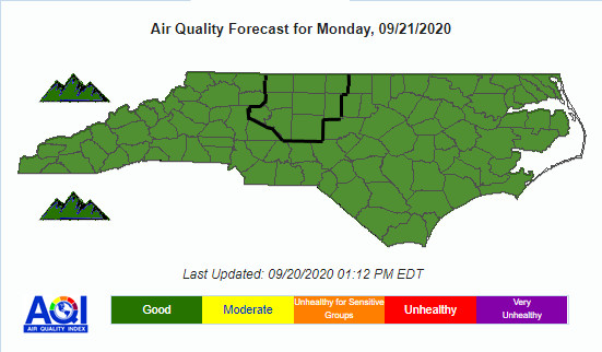
Air quality is in the upper range of green today as ozone and particulate matter levels are exptected to not be a problem today.

Pollen

Pollen levels are expected to be medium today (6.8 out of 12) with ragweed, chenopods, and grasses being the main culprits. Tomorrow is expected to lower (6.0 out of 12).


TROPICAL WEATHER
(The North Atlantic Hurricane Season runs from June 1st to Nov 30th)


Tropical Tidbit from Levi Cowan (video recoded yesterday afternoon)


Tropical Weather Outlook
NWS National Hurricane Center Miami FL
200 AM EDT Mon Sep 21 2020

For the North Atlantic...Caribbean Sea and the Gulf of Mexico:

The National Hurricane Center is issuing advisories on Tropical Storm Beta, located over the western Gulf of Mexico, on Hurricane Teddy, located a couple of hundred miles south-southeast of Bermuda. The National Hurricane Center has issued its last advisory on the remnants of Wilfred, located over the central tropical Atlantic.

1. Post-Tropical Cyclone Paulette is producing a small area of showers and thunderstorms, not far to the southeast of its center of circulation. The system is meandering over marginally warm waters and is expected to begin moving eastward later today. Further development is possible and the system could become a tropical or subtropical cyclone today or tomorrow. For more information about marine hazards associated with this system, see High Seas Forecasts issued by Meteo France.

* Formation chance through 48 hours...medium...60 percent. * Formation chance through 5 days...medium...60 percent.


TROPICAL STOM BETA


Tropical Storm Beta Discussion Number 15
NWS National Hurricane Center Miami FL AL222020
400 AM CDT Mon Sep 21 2020

Beta is struggling this morning. Satellite images show that much of the deep convection associated with the storm has dissipated, and data from the Air Force Hurricane Hunters indicate that the winds have decreased. Based on a combination of flight-level and SFMR data from the aircraft, the initial intensity is lowered to 45 kt. This estimate is also in agreement with an ASCAT pass from a few hours ago that showed peak winds close to 40 kt. It is also worth noting that the tropical-storm-force winds are largely confined to the northern half of the circulation, and these winds should spread across the Texas coast later this morning.

Beta has been moving due westward during the past several hours, with the latest initial motion estimated to be 270/5 kt. In the short term, Beta is expected to resume a west-northwestward motion at a forward speed of about 5 kt, and that motion should take the tropical storm to the Texas coast by tonight. The models differ on how far inland Beta gets over Texas, but the majority of the guidance shows the cyclone stalling just inland on Tuesday in weak steering currents. The combination of an approaching shortwave trough and an amplifying ridge over Florida should cause Beta to turn northeastward along or near the Texas coast late Tuesday and Wednesday, and then farther inland over Louisiana on Thursday. The NHC track forecast is largely an update of the previous one and remains near the various consensus aids.

The tropical storm is certainty feeling the effects of dry and stable air that has wrapped into the circulation. The combination of the dry air mass and 15-20 kt of southwesterly wind shear should limit strengthening through landfall tonight. Steady weakening is forecast after that time due to the storm interacting with land and stronger southwesterly shear. The models are in quite good agreement, and the NHC intensity forecast lies near the high end of the guidance envelope.

Key Messages:

1. The expected slow motion of Beta will produce a long duration rainfall event from the middle Texas coast to southeast Louisiana. Flash, urban, and minor river flooding is likely. Rainfall will also spread northward into the ArkLaTex region and east into the Lower Mississippi Valley and portions of the Southeast through the end of the week. Flash, urban, and isolated minor river flooding is possible.

2. There is the danger of life-threatening storm surge near times of high tide through Tuesday along portions of the Texas and Louisiana coasts within the storm surge warning areas. Residents in these areas should follow advice given by local officials.

3. Tropical-storm-force winds will spread westward across the Texas coast later this morning and continue into Tuesday.


FORECAST POSITIONS AND MAX WINDS

INIT 21/0900Z 27.7N 95.1W 45 KT 50 MPH
12H 21/1800Z 28.0N 96.0W 45 KT 50 MPH
24H 22/0600Z 28.4N 96.6W 40 KT 45 MPH...INLAND
36H 22/1800Z 28.7N 96.5W 35 KT 40 MPH...INLAND
48H 23/0600Z 28.9N 95.8W 30 KT 35 MPH...INLAND
60H 23/1800Z 29.4N 94.7W 25 KT 30 MPH...INLAND
72H 24/0600Z 30.2N 93.2W 25 KT 30 MPH...INLAND
96H 25/0600Z 32.8N 90.5W 20 KT 25 MPH...POST-TROP/INLAND


CROWDFUNDING OR DAY SPONSORSHIP OPPORTUNITIES


If you receive value from what Macon Media provides to the community, please consider becoming a supporter and contribute at least a dollar a month. Those who support Macon Media with at least a dollar a month receive early access to video of some events and meetings before they are made public on the website. Videos and news involving public safety are not subject to early access.


Become a Patron!


Or, if you prefer Pay Pal, try PayPal.me/MaconMedia


Published at 5:00am Monday, September 21, 2020


Saturday, September 19, 2020

Weather Briefing for Saturday, September 19, 2020


OUTLOOK

High pressure will build south into the region, providing dry and cool conditions for the weekend. Dry high pressue will linger atop the region into the middle of next week as temperatures slowly moderate.


---BEGIN SPONSOR SEGMENT ---


Weather Sponsor


Adams Products, a Division of Oldcastle is underwriting the daily weather briefing & public safety updates for the month.

Open 7:30 AM to 4:00 PM, M-F, located at 895 Hickory Knoll Road, Franklin, NC. Visit our Facebook page at: https://www.facebook.com/Adams.Oldcastle.Franklin.NC/

All your masonry needs are available. Our phone number is 828.524.8545, the public is welcome, we’ll help you with your next project.


---END SPONSOR SEGMENT---


News Brief

Supreme Court Associate Justice Ruth BaderGinsburg has died. The Governor has ordered US and NC Flags to emian lowered until her internment. [LINK]

General forecast through Saturday night


Today

Patchy fog in the morning. Otherwise, cloudy, with highs in the 60s. Some locations in thelower elevations could reach 70 or 71. Calm winds in the morning increasing to come out of the northeast around 5 mph.

Saturday Night

Mostly cloudy, with lows ranging from the upper 30s in the higher elevations to the upper 40s in the lower elevations. Light and variable winds.

Sunday

Sunny, with highs ranging from the mid-60s in the higher elevations to thelower 70s in the lower elevations. Calm winds in the morning increasing to comeout of the east around 5 mph in the afternoon.

Sunday Night

Mostly clear, with lows ranging from the upper 30s in the higher elevations tothe low-to-mid 40s in the lower elevations. Light winds out of the east.

Monday

Sunny, with highs in the 60s.

Monday Night

Mostly clear, with lows ranging from the mid-30s in thehigher elevations to the lower 40s in the lower elevations.


HAZARDS

Hazardous weather is not expected at this time.

Air Quality


Air quality is in the upper range of green today as ozone and particulate matter levels are exptected to not be a problem today.

Pollen

Pollen levels are expected to be medium today (6.8 out of 12) with ragweed, chenopods, and grasses being the main culprits. Tomorrow is expected to higher (6.9 out of 12).


TROPICAL WEATHER
(The North Atlantic Hurricane Season runs from June 1st to Nov 30th)


Tropical Tidbit from Levi Cowan (video recoded yesterday afternoon)


Tropical Weather Outlook
NWS National Hurricane Center Miami FL
200 AM EDT Sat Sep 19 2020

For the North Atlantic...Caribbean Sea and the Gulf of Mexico:

The National Hurricane Center is issuing advisories on Tropical Storm Beta, located over the western Gulf of Mexico, on Hurricane Teddy, located over the central Atlantic, and on Tropical Storm Wilfred, located over the eastern tropical Atlantic. The National Hurricane Center has issued its last advisory on Alpha, which became post-tropical over northern Portugal.

1. Post-Tropical Cyclone Paulette is moving southward and is now located just south of the western Azores. The cyclone is forecast to continue southward for the next day or two and then stall over marginally warm waters a few hundred miles south of the Azores. The cyclone could subsequently develop tropical or subtropical characteristics by early next week while it moves little. For more information about marine hazards associated with this system, see High Seas Forecasts issued by Meteo France.

* Formation chance through 48 hours...medium...40 percent. * Formation chance through 5 days...medium...50 percent. 2. A tropical wave is located near the west coast of Africa and will move westward over the far eastern Atlantic during the next few days. Development of this system, if any, will be slow to occur during the next few days.

* Formation chance through 48 hours...low...near 0 percent. * Formation chance through 5 days...low...10 percent.


CROWDFUNDING OR DAY SPONSORSHIP OPPORTUNITIES


If you receive value from what Macon Media provides to the community, please consider becoming a supporter and contribute at least a dollar a month. Those who support Macon Media with at least a dollar a month receive early access to video of some events and meetings before they are made public on the website. Videos and news involving public safety are not subject to early access.


Become a Patron!


Or, if you prefer Pay Pal, try PayPal.me/MaconMedia


Published at 3:45am Saturday, September 19, 2020


Supreme Court Associate Justice Ruth Bader Ginsburg Has Died
Governor Cooper Orders US and NC Flags to Half-Staff Until Her Internment

Supreme Court Associate Justice Ruth Bader Ginsburg died last night. She was 87 years old.

Governor Roy Cooper today ordered all United States and North Carolina flags at state facilities to remain lowered to half-staff until sunset on the date of internment in honor of U.S. Supreme Court Justice Ruth Bader Ginsburg, who passed away Friday. An updated notification will be sent once the date of internment has been established.

Ginsburg was a feminist icon to many, dedicating her life to public service and advocacy for social justice and gender equality. She was the second woman appointed to the Supreme Court of the United States, where she served for more than 27 years.

Statement from Governor Roy Cooper:

"The country has lost a fervent icon of equal rights in the death of Justice Ruth Bader Ginsburg, a legal pioneer for women's rights who insisted on fair treatment for all. Our hearts are with her family and her fellow justices on the Supreme Court. The Court must continue her legacy of justice and fairness."

As a show of respect, individuals, businesses, schools, municipalities, counties and other government subdivisions are encouraged to fly the flag at half-staff for the duration of time indicated.

Please note, all North Carolina flag announcements are issued in accordance to regulations outlined in the US Flag Code. 


Press Release from the Supreme Court:

Associate Justice Ruth Bader Ginsburg died this evening surrounded by her family at her home in Washington, D.C., due to complications of metastatic pancreas cancer. She was 87 years old. Justice Ginsburg was appointed to the Supreme Court by President Clinton in 1993. She was the second woman appointed to the Court and served more than 27 years. She is survived by her two children: Jane Carol Ginsburg (George Spera) and James Steven Ginsburg (Patrice Michaels), four grandchildren: Paul Spera (Francesca Toich), Clara Spera (Rory Boyd), Miranda Ginsburg, Abigail Ginsburg, two step-grandchildren: Harjinder Bedi, Satinder Bedi, and one great-grandchild: Lucrezia Spera. Her husband, Martin David Ginsburg, died in 2010.

Chief Justice John G. Roberts, Jr. said of Justice Ginsburg: “Our Nation has lost a jurist of historic stature. We at the Supreme Court have lost a cherished colleague. Today we mourn, but with confidence that future generations will remember Ruth Bader Ginsburg as we knew her -- a tireless and resolute champion of justice.”

Justice Ginsburg was born in Brooklyn, New York, March 15, 1933. She married Martin D. Ginsburg in 1954. She received her B.A. from Cornell University, attended Harvard Law School, and received her LL.B. from Columbia Law School. She served as a law clerk to the Honorable Edmund L. Palmieri, Judge of the United States District Court for the Southern District of New York, from 1959–1961. From 1961–1963, she was a research associate and then associate director of the Columbia Law School Project on International Procedure. She was a Professor of Law at Rutgers University School of Law from 1963–1972, and Columbia Law School from 1972–1980, and a fellow at the Center for Advanced Study in the Behavioral Sciences in Stanford, California from 1977–1978. In 1971, she was instrumental in launching the Women’s Rights Project of the American Civil Liberties Union, and served as the ACLU’s General Counsel from 1973–1980, and on the National Board of Directors from 1974–1980. She was appointed a Judge of the United States Court of Appeals for the District of Columbia Circuit in 1980. During her more than 40 years as a Judge and a Justice, she was served by 159 law clerks.

While on the Court, the Justice authored My Own Words (2016), a compilation of her speeches and writings.

A private interment service will be held at Arlington National Cemetery.


BIOGRAPHY

Ruth Bader Ginsburg, Associate Justice, was born in Brooklyn, New York, March 15, 1933. She married Martin D. Ginsburg in 1954, and has a daughter, Jane, and a son, James. She received her B.A. from Cornell University, attended Harvard Law School, and received her LL.B. from Columbia Law School. She served as a law clerk to the Honorable Edmund L. Palmieri, Judge of the United States District Court for the Southern District of New York, from 1959–1961. From 1961–1963, she was a research associate and then associate director of the Columbia Law School Project on International Procedure. She was a Professor of Law at Rutgers University School of Law from 1963–1972, and Columbia Law School from 1972–1980, and a fellow at the Center for Advanced Study in the Behavioral Sciences in Stanford, California from 1977–1978. In 1971, she was instrumental in launching the Women’s Rights Project of the American Civil Liberties Union, and served as the ACLU’s General Counsel from 1973–1980, and on the National Board of Directors from 1974–1980. She was appointed a Judge of the United States Court of Appeals for the District of Columbia Circuit in 1980. President Clinton nominated her as an Associate Justice of the Supreme Court, and she took her seat August 10, 1993.


POSSIBLE NOMINEES


Last week, the President released a list of people that he said would be the top of his list to take any vacant Supreme Court seat. The list surprised everyone, including some of the people on the list. It included seven federal appeals court justices and two U.S. senators. The list includes:

• Amy Coney Barrett, a United States Circuit Judge of the United States Court of Appeals for the Seventh Circuit. Barrett is the first and only woman to occupy an Indiana seat on the Seventh Circuit Court of Appeals.
• Amul Roger Thapar, a United States Circuit Judge of the United States Court of Appeals for the Sixth Circuit.
• Mike Lee, a United States Senator from Utah. A conservative, libertarian-leaning Republican, Lee has served in the Senate since January 3, 2011.
• Bridget Bade, a judge on the United States Court of Appeals for the Ninth Circuit.
• Daniel Cameron, the Kentucky Attorney General and former legal counsel to McConnell.
• Tom Cotton, U.S. senator from Arkansas who said after Trump named him that if he was ever placed on the Supreme Court he would seek to overturn Roe v. Wade.
• Paul Clement, an attorney who previously served as Solicitor General of the United States and has argued over 100 cases before the Supreme Court.
• Ted Cruz, a U.S. Senator from Texas who has alternated between staunch Trump foe to occasional ally.
• Stuart Kyle Duncan, judge on the U.S. Court of Appeals for the Fifth Circuit.
• Steven Engel, Assistant Attorney General for the Office of Legal Counsel of the United States Department of Justice.
• Noel Francisco, the former Solicitor General of the United States.
• Josh Hawley, U.S. senator for the state of Missouri. Hawley tweeted that he has “no interest in the high court” and will “look forward to confirming constitutional conservatives” as a member of the senate.
• James Ho, judge on the U.S. Court of Appeals for the Fifth Circuit.
• Gregory Katsas, judge on the U.S. Court of Appeals for the District of Columbia Circuit.
• Barbara Lagoa, judge on the U.S. Court of Appeals for the Eleventh Circuit.
• Christopher Landau, U.S. ambassador to Mexico.
• Carlos Muñiz, justice on the Supreme Court of Florida.
• Martha Pacold, judge on the U.S. District Court for the Northern District of Illinois.
• Peter Phipps, judge on the U.S. Court of Appeals for the Third Circuit.
• Sarah Pitlyk, judge on the U.S. District Court for the Eastern District of Missouri.
• Allison Jones Rushing, judge on the U.S. Court of Appeals for the Fourth Circuit.
• Kate Todd, deputy assistant to the president and deputy counsel to the president.
• Lawrence VanDyke, judge on the U.S. Court of Appeals for the Ninth Circuit.


The Supreme Court website has an extensive list of Frequently asked questions and answers about the nomination process on their website. [LINK]

Read more about the death and its implications for the 2020 Presidential Election at the following links:

Howe on the Court [LINK]

POLITICO: "What's next in the Senate's colossal Supreme Court fight" [LINK]

POLITICO: "How RBG's death will impact hot-button issues before the Supreme Court" [LINK]

POLITICO: "McConnell Pursues Scorched-Earth Tactics on Ground That is Already Scorched" [LINK]

MSN [LINK]

Fox News [LINK]

ABC [LINK]

NBC [LINK]

New York Times: "Will the Election Turn on R.B.G.?" [LINK]

Constitution Center: "Why does the Supreme Court have nine Justices?" [LINK]


CROWDFUNDING OR DAY SPONSORSHIP OPPORTUNITIES

If you receive value from what Macon Media provides to the community, please consider becoming a supporter and contribute at least a dollar a month. Those who support Macon Media with at least a dollar a month receive early access to video of some events and meetings before they are made public on the website. Videos and news involving public safety are not subject to early access.


Become a Patron!


Or, if you prefer Pay Pal, try PayPal.me/MaconMedia


Published at 2:15am on Saturday, September 19, 2020

Friday, September 18, 2020

Sepsis Awareness Month Offers Opportunity to Learn About Sepsis Symptoms, Why Infection Prevention is Critical, and That Prompt Treatment is Critical


Monthly Column by Karen S Gorby
September 18, 2020


The human body is amazingly designed — when working well, its many systems and the organs they serve work in exquisite concert with each other. They help us do everything from processing outside stimuli to digesting food, from facilitating growth to delivering nutrient-rich blood to and from our cells and throughout our immune system, which, when working properly, is ever-ready to fight invaders.

Unfortunately, these normally efficient systems can malfunction, and then we become ill. One of the most serious sicknesses that, if not tended to promptly and carefully monitored, is sepsis. Alarming statistics surround sepsis. According to the Centers for Disease Control (CDC), about 1.7 million Americans are diagnosed with sepsis annually and almost 270,000 people die from it, which works out to 1 out of every 3 patients. Since September is Sepsis Awareness Month, I thought it would be the ideal time to learn about the condition, how to protect yourself and your loved ones, and about the safety measures we have in place at Angel Medical Center (AMC) to prevent and treat it.

Jeanie Bollinger, MSN, RN, ACCNS-AG, CCRN-K, works at Mission Health as an Acute Care Clinical Specialist, and is not only versed in the signs and symptoms of sepsis, she has treated many patients with sepsis. “Basically, sepsis is your body’s overactive and toxic response to an infection, and the danger with sepsis is its ability to escalate very rapidly,” she explains. She adds that when sepsis transitions into the serious, life-threatening condition of septic shock, the organs begin to shut down and a patient experiences serious health crises, from respiratory failure to nosediving blood pressure.

Although some groups are at higher risk for sepsis, such as the very young and very old, those with compromised immune systems, and the many individuals who take a type of prescription medications called biologics, which alter how the immune system functions, it can affect anyone. “Sepsis is an equal opportunity killer,” declares Bollinger. “It strikes whether you’re rich or poor, young or old, healthy or living with a chronic illness.”

“It all begins with an infection, and it doesn’t have to be severe,” says Bollinger, “which is why we should be adamant about whether we’re at risk for infection, and an infection means anything from a small cut on the skin to a respiratory infection like pneumonia.” In fact, pneumonia is the number one cause of sepsis, and urinary tract infections come in second — yet another good reason for both children and adults to keep current with their vaccines.

The It’s About Time™ campaign is a nationwide initiative to educate the public about the dangers of sepsis and why it’s critical to get care as soon as possible. An easy-to-remember acronym that clinicians use to educate their patients about the top sepsis symptoms is TIME: T points to a lower or higher than normal temperature, I is for knowing how to identify an infection, M connotes mental confusion, and E stands for extreme illness, that is, the patient generally feels terrible and might be suffering severe symptoms such as respiratory distress and much discomfort. Another symptom Bollinger shares that she has seen frequently is when a patient’s skin becomes mottled and blue, often in the knees. “It’s good to try to remember that if anything is different from someone’s baseline vital signs, exhaustion level, or alertness, it’s best to seek medical treatment,” she says.

Bollinger stresses that early detection can’t be emphasized enough in terms of preventing the serious trajectory of sepsis symptoms, and markedly improving the chances of survival. “The challenge with sepsis is that it’s subtle at first, and then it morphs suddenly, making your immune system turn on itself instead of fighting infection as it should. This is why we’re trying to talk to patients about sepsis so that if they end up in their doctor’s office or the Emergency Room, they can say to their caregiver ‘Could it be sepsis?’” The double layer of awareness means that both patient and provider are on alert and a patient’s chances of being diagnosed at a later stage is reduced. “Simply put,” says Bollinger, “if you don’t have an infection, you can’t get sepsis.”

Fortunately, across the Mission Health System, and here at AMC, every patient who comes to the Emergency Department or is an inpatient is screened for sepsis upon entrance and throughout their hospital stay. Sophisticated processes have been developed for screening and monitoring, many of which involve medical technology that works constantly in the background to monitor patients’ vital signs. “If a patient screens positive for sepsis,” explains Bollinger, “we have automated lab data that assists the provider in identifying subtle signs of organ dysfunction, before a patient’s blood pressure crashes, for example. It’s an important complement to the provider’s own assessment.”

We at AMC also urge community members not to wait if they have any of the symptoms of sepsis, including during this time of COVID-19. Angel Medical Center remains one of the cleanest and safest places you could possibly be, and safety precautions remain in place to protect patients and staff.

Set a goal for this month to have a conversation with a friend, family member, or your provider about sepsis. Any case that can be prevented means a potential life saved.

In closing, I want to remind you to stay safe. COVID-19 continues to be present, and it is important that we continue to practice social distancing, wearing a mask and washing our hands. I also want to make you aware of our Insurance Assistance Hotline, which offers help for those struggling with being uninsured during the pandemic. Our trained professionals are there to assist those who need help applying for emergency medical coverage, from COBRA insurance to Medicaid. You can contact them Monday through Friday from 8am to 6pm at (833) 541-5757.


ABOUT KAREN GORBY

Karen S. Gorby, RN, MSN, MBA, CENP, FACHE, is Chief Executive Officer and Chief Nursing Officer of Angel Medical Center. Gorby is a Fellow of the American College of Healthcare Executives (ACHE). For nearly three decades, she has served hospitals and health systems in Ohio before assuming her role at Angel Medical Center. Gorby received her MSN from Saint Joseph’s College in Standish, Maine, and her MBA from Wright State University in Fairborn, Ohio.


ABOUT ANGEL MEDICAL CENTER

Angel Medical Center, a member of Mission Health, an operating division of HCA Healthcare, is a full-service community hospital serving Macon and the surrounding counties. Located in Franklin, North Carolina, Angel Medical Center is a Top 100 Critical Access Hospital offering inpatient services that include an intensive care unit, and a medical and surgical unit. Angel Medical Center has also been named an Acute Stroke Ready hospital by The Joint Commission and American Heart Association/American Stroke Association. Outpatient services include a wound clinic, chemotherapy services, a full laboratory, digital mammography, CT, MRI, nuclear medicine, rehab therapy, as well as surgical and endoscopy services. The hospital also operates Mission My Care Now Franklin and CarePartners Hospice & Home Health. For more information, please visit missionhealth.org/angel.
ABOUT MISSION HEALTH

Mission Health, an operating division of HCA Healthcare, is based in Asheville, North Carolina, and is the state’s sixth largest health system. Mission Health operates six hospitals, numerous outpatient and surgery centers, post-acute care provider CarePartners, long-term acute care provider Asheville Specialty Hospital and the region’s only dedicated Level II trauma center. With approximately 12,000 colleagues and 2,000 volunteers, Mission Health is dedicated to improving the health and wellness of the people of western North Carolina. For more information, please visit missionhealth.org or @MissionHealthNC.

Lowering Of NC Flags To Half-Staff In Honor of Henderson County Deputy Sheriff Ryan Hendrix


Governor Roy Cooper today ordered all North Carolina flags at state facilities to be lowered to half-staff beginning today, Friday, September 18, 2020 until sunset on Saturday, September 19, 2020 in honor of Henderson County Deputy Sheriff Ryan Hendrix who died in the line of duty on September 10, 2020

An eight year veteran of the Henderson County Sheriff's Office, Deputy Hendrix was working at the rank of detective serving as a uniformed investigator. Also a veteran of the US Marines, Deputy Hendrix served on the Henderson County Sheriff's Office SWAT team and was a field training officer.

Services for Deputy Hendrix will be held today at the Mud Creek Baptist Church in Hendersonville, North Carolina.

Statement from Governor Roy Cooper:

"Kristin and I are praying for Ryan Hendrix, who died while trying to keep his community safe. Our thoughts are with his loved ones, the Henderson County Sheriff’s Dept. and the entire community."

As a show of respect, individuals, businesses, schools, municipalities, counties and other government subdivisions are encouraged to fly the flag at half-staff for the duration of time indicated.

Please note, all North Carolina flag announcements are issued in accordance to regulations outlined in the US Flag Code.


CROWDFUNDING OR DAY SPONSORSHIP OPPORTUNITIES


If you receive value from what Macon Media provides to the community, please consider becoming a supporter and contribute at least a dollar a month. Those who support Macon Media with at least a dollar a month receive early access to video of some events and meetings before they are made public on the website. Videos and news involving public safety are not subject to early access.

Become a Patron!


Or, if you prefer Pay Pal, try PayPal.me/MaconMedia
Published at 8:22am on Friday, September 18, 2020

Weather Briefing for Friday, September 18, 2020


OUTLOOK

Heavy rainfall and isolated thunderstorms associated with Tropical Depression Sally will impact much of the area today with showers and storms tapering off by early Friday morning. Thereafter, dry and cool high pressure will dominate the weather through the middle of next week.


---BEGIN SPONSOR SEGMENT ---


Weather Sponsor


Adams Products, a Division of Oldcastle is underwriting the daily weather briefing & public safety updates for the month.

Open 7:30 AM to 4:00 PM, M-F, located at 895 Hickory Knoll Road, Franklin, NC. Visit our Facebook page at: https://www.facebook.com/Adams.Oldcastle.Franklin.NC/

All your masonry needs are available. Our phone number is 828.524.8545, the public is welcome, we’ll help you with your next project.


---END SPONSOR SEGMENT---


News Brief

COVID-19 pdate for Wednesday, September 16, 2020 [LINK]

General forecast through Saturday night


Today

Partly sunny, with highs ranging from the upper 60s in the higher elevations to the mid-70s in the lower elevations. Calm winds early increasing to come out of the northwest 5 to 10 mph by midmorning.

Tonight

Mostly cloudy, with lows ranging from the upper 40s in the higher elevations to the mid-50sin the lower elevations. WInds out of the northwest around 5 mph becoming calm before midnight.

Saturday

Mostly cloudy, with highs ranging from the lower 60s in the higher elevations to the lower 70s in the lower elevations. Light winds out of the southeast.

Saturday Night

Mostly cloudy, with lows ranging from the upper 30s in the higher elevations to the upper 40s in the lower elevations. Calm winds.

Sunday

Sunny, with highs ranging from near 60 in the higher elevations to near 70 in the lower elevations.

Sunday Night

Mostly clear, with low ranging from the upper 30s in the higher elevations to the low-to-mid 40s in the lower elevations.


HAZARDS

Hazardous weather is not expected at this time.

Air Quality


Air quality is in the upper range of green today as ozone and particulate matter levels are exptected to not be a problem today.

Pollen

Pollen levels are expected to be medium today (6.4 out of 12) with ragwee,, chenopods, and grasses being the main culprits. Tomorrow is expected to higher (7.0 out of 12).


TROPICAL WEATHER
(The North Atlantic Hurricane Season runs from June 1st to Nov 30th)


Tropical Tidbit from Levi Cowan (video recoded yesterday afternoon)


Tropical Weather Outlook
NWS National Hurricane Center Miami FL
200 AM EDT Fri Sep 18 2020

For the North Atlantic...Caribbean Sea and the Gulf of Mexico:

The National Hurricane Center is issuing advisories on Hurricane Teddy, located over the central tropical Atlantic, and on Tropical Depression Twenty-Two, located over the southwestern Gulf of Mexico.

1. Showers and thunderstorms associated with an area of low pressure located a few hundred miles southwest of the Cabo Verde Islands have increased during the past several hours. Earlier satellite-derived wind data indicated that this system does not yet have a well-defined center, but it is producing winds near tropical-storm-force to its east. Environmental conditions are expected to be conducive for additional development during the next day or two and a tropical depression or tropical storm could form before the end of the week. This system is forecast move west-northwestward at 10 to 15 mph through the weekend.

* Formation chance through 48 hours...medium...60 percent.
* Formation chance through 5 days...medium...60 percent.

2. A small low pressure system is embedded within a larger non-tropical low. Although showers and thunderstorms associated with the smaller low are showing signs of organization, the system will soon move inland over Portugal and further tropical or subtropical development is unlikely. The low is producing gale-force winds, and will likely bring gusty winds and brief periods of heavy rain to portions of western Portugal today and tonight. For more information about potential hazards in Portugal, please see products issued by the Portuguese Institute for the Sea and the Atmosphere (IPMA). For more information about marine hazards associated with this system, see High Seas Forecasts issued by Meteo France.

* Formation chance through 48 hours...low...20 percent.
* Formation chance through 5 days...low...20 percent.

3. Post-tropical cyclone Paulette is located several hundred miles north-northwest of the Azores. The cyclone is forecast to move quickly southward for the next several days and then stall over marginally warm waters a few hundred miles south or south-southwest of the Azores by the end of the weekend. The cyclone could subsequently redevelop tropical characteristics late this weekend or early next week while it moves little.

* Formation chance through 48 hours...low...10 percent.
* Formation chance through 5 days...low...20 percent.

4. Another tropical wave is forecast to move off the west coast of Africa by early Saturday. Some gradual development of the system will be possible thereafter while it moves generally west-northwestward over the far eastern Atlantic.

* Formation chance through 48 hours...low...near 0 percent.
* Formation chance through 5 days...low...20 percent.


CROWDFUNDING OR DAY SPONSORSHIP OPPORTUNITIES


If you receive value from what Macon Media provides to the community, please consider becoming a supporter and contribute at least a dollar a month. Those who support Macon Media with at least a dollar a month receive early access to video of some events and meetings before they are made public on the website. Videos and news involving public safety are not subject to early access.


Become a Patron!


Or, if you prefer Pay Pal, try PayPal.me/MaconMedia


Published at 7:00am Thursday, September 17, 2020